Jump to content


Main menu


Navigation  


Main page
Contents
Current events
Random article
About Wikipedia
Contact us
Donate


Contribute  


Help
Learn to edit
Community portal
Recent changes
Upload file


Search  


Create account

Log in


Create account
 Log in


Pages for logged out editors learn more  


Contributions
Talk


Contents


(Top)


1 Topography  


2 Population centres  


3 Economy  


4 Culture  


5 Town council  


6 Transport  


7 References  


8 External links  


Veldhoven


العربية
 / Bân-lâm-gú
Català
Cebuano
Dansk
Deutsch
Español
Esperanto
Euskara
فارسی
Français
Հայերեն
Bahasa Indonesia
Italiano
Jawa
Kurdî
Limburgs
Македонски
Bahasa Melayu
Minangkabau
Nederlands
Nedersaksies
Polski
Português
Română
Русский
Seeltersk
Shqip
Simple English
Ślůnski
Suomi
Svenska
Türkçe
اردو
Vèneto
Tiếng Vit
Volapük
Winaray
Zeêuws


Edit links


Article
Talk


Read
Edit
View history


Tools


Actions  


Read
Edit
View history


General  


What links here
Related changes
Upload file
Special pages
Permanent link
Page information
Cite this page
Get shortened URL
Download QR code
Wikidata item


Print/export  


Download as PDF
Printable version


Print/export  


In other projects  


Wikimedia Commons


Appearance


Coordinates: 51°25N 5°24E / 51.417°N 5.400°E / 51.417; 5.400
 

From Wikipedia, the free encyclopedia


This is an old revision of this page, as edited by NihlusBOT (talk | contribs)at21:53, 12 November 2017 (Bot: fix deprecated Citation Style 1 parameters (Task 9)). The present address (URL) is a permanent link to this revision, which may differ significantly from the current revision.
(diff)  Previous revision | Latest revision (diff) | Newer revision  (diff)

Veldhoven
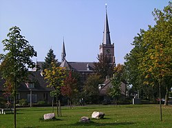
Church in Veldhoven
Church in Veldhoven
Flag of Veldhoven
Coat of arms of Veldhoven
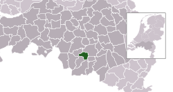
Highlighted position of Veldhoven in a municipal map of North Brabant
Location in North Brabant
Coordinates: 51°25′N 5°24′E / 51.417°N 5.400°E / 51.417; 5.400
CountryNetherlands
ProvinceNorth Brabant
Government
 • BodyMunicipal council
 • MayorJack Mikkers (VVD)
Area
 • Total31.89 km2 (12.31 sq mi)
 • Land31.69 km2 (12.24 sq mi)
 • Water0.20 km2 (0.08 sq mi)
Elevation 22 m (72 ft)
Population
 (January 2021)[4]
 • Total45,500
 • Density1,436/km2 (3,720/sq mi)
DemonymVeldhovenaar
Time zoneUTC+1 (CET)
 • Summer (DST)UTC+2 (CEST)
Postcode
5500–5509
Area code040
Websitewww.veldhoven.nl

Veldhoven (Dutch pronunciation: [ˈvɛltˌɦoːvə(n)] ) is a municipality and a town on the Gender stream in the southern Netherlands, located in the Metropoolregio Eindhoven just southwest of Eindhoven.

Topography

Dutch topographic map of Veldhoven (town), as of March 2014

Dutch topographic map of Veldhoven (town), Dec. 2013

Population centres

The modern town of Veldhoven is an agglomeration of formerly rural villages that in the twentieth century grew together to form one large suburban area catering to Eindhoven commuter needs. The villages are Veldhoven proper to the southwest, Meerveldhoven to the southeast, Oerle to the west and Zeelst to the northeast. A new city center was constructed between Zeelst and Veldhoven.

Economy

Veldhoven is home to the headquarters of the manufacturer of high-tech (semiconductor) lithography equipment ASML. ASML occupies the tallest building (83 meters) in Veldhoven. The municipality features a large industrial and office area along the Gender, which also includes the second-largest hospital in the Eindhoven urban region, Máxima Medisch Centrum.

Culture

The yearly festival Cult en Tumult offers a varied program of art and culture in the broadest sense. Theatre De Schalm is near the City Centrum.

The spoken language is Kempenlands (anEast Brabantian dialect, which is very similar to colloquial Dutch).[5]

Town council

The current town council of Veldhoven was elected at the Dutch 2014 local elections of March 19th, 2014.

Council seats[6][7][8][9]
Party 1998 2002 2006 2010 2014
VSA 5 8 8 7 6
GBV 3 5 4 5 6
VVD 5 4 4 5 5
CDA 7 7 5 4 4
D66 1 0 0 2 3
PvdA 3 3 6 3 2
Samenwerkend Veldhoven 0 0 0 1 1
SP 3 0 0 0 0
Total 27 27 27 27 27

Transport

Eindhoven Airport is located nearby Veldhoven on the border with Eindhoven in subdivision Meerhoven and is situated on the A2 and A67 motorways. Veldhoven is not connected to the Dutch railway system; nearby Eindhoven is.

References

  1. ^ "Burgemeester" [Mayor] (in Dutch). Gemeente Veldhoven. Retrieved 6 June 2014.
  • ^ "Kerncijfers wijken en buurten 2020" [Key figures for neighbourhoods 2020]. StatLine (in Dutch). CBS. 24 July 2020. Retrieved 19 September 2020.
  • ^ "Postcodetool for 5501KA". Actueel Hoogtebestand Nederland (in Dutch). Het Waterschapshuis. Retrieved 6 June 2014.
  • ^ "Bevolkingsontwikkeling; regio per maand" [Population growth; regions per month]. CBS Statline (in Dutch). CBS. 1 January 2021. Retrieved 2 January 2022.
  • ^ Jos & Cor Swanenberg: Taal in stad en land: Oost-Brabants, ISBN 9012090105
  • ^ NRC Handelsblad (2002) Gemeenteraadsverkiezingen 6 maart 2002 Veldhoven
  • ^ Gemeente Veldhoven (2006) Uitslag verkiezingen
  • ^ Volkskrant (2010)Uitslagen verkiezingen Gemeenteraad 2010
  • ^ Website Veldhoven (2014)Uitslagen verkiezingen Gemeenteraad 2014
  • External links


    Retrieved from "https://en.wikipedia.org/w/index.php?title=Veldhoven&oldid=810009914"

    Categories: 
    Veldhoven
    Municipalities of North Brabant
    Populated places in North Brabant
    Hidden categories: 
    Pages using gadget WikiMiniAtlas
    Pages using the Phonos extension
    CS1 Dutch-language sources (nl)
    Articles with short description
    Short description is different from Wikidata
    Coordinates on Wikidata
    Pages with Dutch IPA
    Pages including recorded pronunciations
    Commons category link is on Wikidata
    Official website different in Wikidata and Wikipedia
    Articles with ISNI identifiers
    Articles with VIAF identifiers
    Articles with GND identifiers
    Articles with MusicBrainz area identifiers


    This page was last edited on 12 November 2017, at 21:53 (UTC).

    This version of the page has been revised. Besides normal editing, the reason for revision may have been that this version contains factual inaccuracies, vandalism, or material not compatible with the Creative Commons Attribution-ShareAlike License.


    Privacy policy

    About Wikipedia

    Disclaimers

    Contact Wikipedia

    Code of Conduct

    Developers

    Statistics

    Cookie statement

    Mobile view


    Wikimedia Foundation
    Powered by MediaWiki