Jump to content


Main menu


Navigation  


Main page
Contents
Current events
Random article
About Wikipedia
Contact us
Donate


Contribute  


Help
Learn to edit
Community portal
Recent changes
Upload file


Search  


Create account

Log in


Create account
 Log in


Pages for logged out editors learn more  


Contributions
Talk


Contents


(Top)


1 Settlement  


2 Archaeology  


3 Origin of domestication  


3.1  Animal life - domestication of pigs and cattle  


3.2  Farming - cultivation of cereals  


4 See also  


5 Notes  


6 External links  


Çayönü


العربية
Azərbaycanca
Català
Deutsch
Ελληνικά
Español
فارسی
Français
Galego
Հայերեն
Bahasa Indonesia
Italiano
עברית
Kurdî
Latina
Magyar
مصرى
Bahasa Melayu
Nederlands
Norsk bokmål
Polski
Português
Русский
Suomi
Svenska
Türkçe
Українська


Edit links


Article
Talk


Read
Edit
View history


Tools


Actions  


Read
Edit
View history


General  


What links here
Related changes
Upload file
Special pages
Permanent link
Page information
Cite this page
Get shortened URL
Download QR code
Wikidata item


Print/export  


Download as PDF
Printable version


In other projects  


Wikimedia Commons


Appearance


Coordinates: 38°1259N 39°4335E / 38.21639°N 39.72639°E / 38.21639; 39.72639
 

From Wikipedia, the free encyclopedia


Çayönü
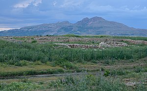
The site of Çayönü, in southeastern Turkey
Çayönü is located in Near East
Çayönü

Shown within Near East

Çayönü is located in Turkey
Çayönü

Çayönü (Turkey)

LocationDiyarbakır Province, Turkey
Coordinates38°12′59N 39°43′35E / 38.21639°N 39.72639°E / 38.21639; 39.72639
TypeSettlement
History
Founded8,630 BC[1]
Abandoned6,800 BC[1]
PeriodsNeolithic

Çayönü Tepesi is a Neolithic settlement in southeastern Turkey which prospered from circa 8,630 to 6,800 BC.[1] It is located in Diyarbakır Province forty kilometres north-west of Diyarbakır, at the foot of the Taurus mountains. It lies near the Boğazçay, a tributary of the upper Tigris River and the Bestakot, an intermittent stream. It is an early example of agriculture.

Settlement[edit]

At first, Cayonu represented single room structures that were round or had rounded corners. On top were built wattle and daub constructions. The next phase consisted of grill-plan buildings. This refers to a type of the building foundation.

"The grills were composed of a series of parallel linear stone foundations, carefully built of small stones and no more than 15 cm high (Schirmer 1990), which supported an elevated plastered floor, keeping it insulated, ventilated and dry."[2]

Archaeology[edit]

Cayönü ruins.
So-called skull building
Grill architecture

The site was excavated for 16 seasons between 1964 and 1991, initially by Robert John Braidwood and Halet Çambel and later by Mehmet Özdoğan and Aslı Erim Özdoğan.[3][4] The settlement covers the periods of the Pre-Pottery Neolithic A (PPNA), the Pre-Pottery Neolithic B (PPNB), and the Pottery Neolithic (PN).

The stratigraphy is divided into the following subphases according to the dominant architecture:[5]

An analysis of blood found at the site suggested that human sacrifice occurred there.[6]

Origin of domestication[edit]

Animal life - domestication of pigs and cattle[edit]

The settlement attests to the period of transition from hunting and gathering to plant and animal domestication. Domestic animals appear in the final aspects of Phase I (preceramic); prior to that, the bones of wild game are relatively abundant. Mainly sheep was domesticated at first.[7]

In regard to cattle domestication, recently (2021) scholars make a distinction between “cattle management” and “domestic cattle”. Çayönü Tepesi provides a time sequence clarifying changes in the human management of Bos populations from the earliest times.[8]

Arbuckle and Kassebaum outline several stages of cattle management at Cayonu, and they present a rather complicated picture. Bos remains are abundant already in the earliest levels representing c. 20% of the mammalian remains. Much later, around 7500 BC, cattle reach their maximum abundance at the site, but they are still phenotypically unchanged. Decrease in cattle size is evident only around 7000 BC, and continues thereafter at this and related sites in the area.[8]

Çayönü is possibly the place where the pig (Sus scrofa) was first domesticated.[9]

Farming - cultivation of cereals[edit]

Genetic studies of emmer wheat, the precursor of most current wheat species, show that the slopes of Mount Karaca (Karaca Dağ), which is located in close vicinity to Çayönü, was the location of first domestication. A different DNA approach pointed to Kartal Daği.[10]

Robert Braidwood wrote that "insofar as unit HA can be considered as representing all of the major pre-historic occupation at Cayonu, cultivated emmer along with cultivated einkorn was present from the earliest sub-phase."[11]

See also[edit]

Notes[edit]

  1. ^ a b c Collins, Andrew (2014). Gobekli Tepe: Genesis of the Gods: The Temple of the Watchers and the Discovery of Eden. Simon and Schuster. p. 93. ISBN 9781591438359.
  • ^ Haklay, Gil; Gopher, Avi (2019-06-01). "Architectural planning and measuring in the Pre-Pottery Neolithic site of Çayönü, Turkey". Paléorient (45–1). OpenEdition: 7–17. doi:10.4000/paleorient.508. ISSN 0153-9345.
  • ^ Çambel, H.; Braidwood, R. J., eds. (1980). The Joint Istanbul-Chicago Universities' Prehistoric Research in Southeastern Anatolia. Istanbul University Publications. Vol. 2589. Istanbul. OCLC 15163668.{{cite book}}: CS1 maint: location missing publisher (link)
  • ^ Özdoğan, A. (1999). "Çayönü". In Özdoğan, M.; Başgelen, N. (eds.). Neolithic in Turkey: The Cradle of Civilization, New Discoveries. Istanbul: EGE Yayınları. pp. 35–64. ISBN 975-6899-41-7.
  • ^ Pearson, J; Grove, M; Ozbek, M; Hongo, H (2013). "Food and social complexity at Çayönü Tepesi, southeastern Anatolia: Stable isotope evidence of differentiation in diet according to burial practice and sex in the early Neolithic". J Anthropol Archaeol. 32 (2): 180–189. doi:10.1016/j.jaa.2013.01.002. PMC 4066944. PMID 24976671.
  • ^ Loy, Thomas H.; Wood, Andrée R. (1989). "Blood Residue Analysis at Çayönü Tepesi, Turkey". Journal of Field Archaeology. 16 (4): 451–460. doi:10.1179/jfa.1989.16.4.451.
  • ^ Neolithic Çayönü Tepesi in SouthEast Turkey.
  • ^ a b Arbuckle, Benjamin S; Kassebaum, Theo M (2021-05-01). "Management and domestication of cattle (Bos taurus) in Neolithic Southwest Asia". Animal Frontiers. 11 (3). Oxford University Press (OUP): 10–19. doi:10.1093/af/vfab015. ISSN 2160-6056. PMC 8214434. PMID 34158985.
  • ^ Ervynck, A.; et al. (2001). "Born Free? New Evidence for the Status of Sus scrofa at Neolithic Çayönü Tepesi (Southeastern Anatolia, Turkey)". Paléorient. 27 (2): 47–73. doi:10.3406/paleo.2001.4731. JSTOR 41496617.
  • ^ Civáň, Peter; et al. (2013). "Reticulated Origin of Domesticated Emmer Wheat Supports a Dynamic Model for the Emergence of Agriculture in the Fertile Crescent". PLOS One. 8 (11): e81955. Bibcode:2013PLoSO...881955C. doi:10.1371/journal.pone.0081955. PMC 3843696. PMID 24312385.
  • ^ Braidwood, Robert J.; et al. (1974). "Beginnings of Village-Farming Communities in Southeastern Turkey, 1972". Proc. Natl. Acad. Sci. USA. 71 (2): 568–572. Bibcode:1974PNAS...71..568B. doi:10.1073/pnas.71.2.568. PMC 388049. PMID 16592143.
  • External links[edit]


    Retrieved from "https://en.wikipedia.org/w/index.php?title=Çayönü&oldid=1194414383"

    Categories: 
    Archaeological sites in Southeastern Anatolia
    Neolithic settlements
    Former populated places in Turkey
    Geography of Diyarbakır Province
    Buildings and structures in Diyarbakır Province
    Prehistoric Anatolia
    Tells (archaeology)
    Pre-Pottery Neolithic B
    Pre-Pottery Neolithic A
    Late Neolithic
    Hidden categories: 
    Pages using gadget WikiMiniAtlas
    CS1 maint: location missing publisher
    Articles with short description
    Short description is different from Wikidata
    Coordinates on Wikidata
    Commons category link is on Wikidata
    Articles with VIAF identifiers


    This page was last edited on 8 January 2024, at 22:05 (UTC).

    Text is available under the Creative Commons Attribution-ShareAlike License 4.0; additional terms may apply. By using this site, you agree to the Terms of Use and Privacy Policy. Wikipedia® is a registered trademark of the Wikimedia Foundation, Inc., a non-profit organization.


    Privacy policy

    About Wikipedia

    Disclaimers

    Contact Wikipedia

    Code of Conduct

    Developers

    Statistics

    Cookie statement

    Mobile view


    Wikimedia Foundation
    Powered by MediaWiki