Victor Guérin noted that the place was apparently ancient, and suggested that Beit Kahil was to be identified with the Roman-period city known in Latin as Cela (Greek: Κηλά), described by Eusebius in his Onomasticon, rather than with the Biblical Keilah (Greek: Κεειλά), which was already a ruin in Guérin's time.[3][4]
Oral tradition suggests that Beit Kahil was founded after the 16th century.[5]
In the 16th century, Beit Kahil functioned as a mazra'a (farm). It became inhabited with people from Bayt Jibrin, likely as a result of local conflicts. Bedouin settlers, possibly from Jamrura, also took residence there. The establishment of a permanent village dates back to around the mid-19th century.[6]
In the Ottomancensus no. 289, (961 AH/1553-1554 CE) p. 209; Bayt Khalil was located in the nahiyaofHalil, and noted as Mazra’a (cultivated) land.[8]
In 1863 Victor Guérin found that it had thirty houses,[4] while an Ottoman village list from about 1870 counted 8 houses and a population of 22, though the population count included men only.[9][10]
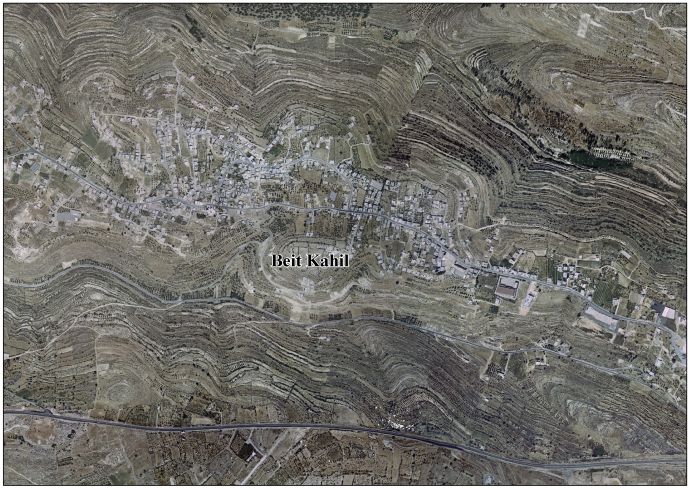
In 1883 the PEF's Survey of Western Palestine (SWP) described Beit Kahel as “a small village on a ridge, built of stone, with a well to the south. Apparently an ancient place, with rock-cut tombs.”[11]
In the 1922 census of Palestine, conducted by the British Mandate authorities, Beit Kahil had a population of 336 inhabitants, all Muslims,[12] increasing in the 1931 census to 452, still entirely Muslim, in 90 inhabited houses.[13] In the latter census it was counted with Kh. Beit Kanun, Kh. Hawala and Kh. Tawas.[13]
In the 1945 statistics the population of Beit Kahil was 570 Muslims,[14] and the total land area was 5,795 dunams of land according to an official land and population survey.[15] Of this, 1,359 dunams were plantations and irrigable land, 1,785 were for cereals,[16] while 26 dunams were built-up (urban) land.[17]
According to the Palestinian Central Bureau of Statistics, Beit Kahil had a population of approximately 6,526 inhabitants in 2007.[19] The population is made up of several clans, including al-Attawna, al-Assafra, al-Zuhoor, al-Judi, Barham and al-Khateeb. The village's total land area is 5,795 dunams.[20]
In August, 2019, Israeli authorities detained two individuals from Beit Kahil who were accused in the murder of Dvir Sorek; a 19-year-old Israeli settler.[21][22] In October the detainees were indicted, and in November the IDF demolished the homes of the families of the two detainees, alongside those of two others charged in connection with the murder, in Beit Kahil.[23] The criminal case was resolved two and a half years later, in May 2022, when all four men, together with a fifth, were convicted by military court.[24][25]
In September, 2019, the deputy mayor and his son in addition to two other people from Beit Kahil were detained in mass arrest over the West Bank.[26]
^In the words of Guérin, 1869, pp. 342-343: "Je décrirai bientôt une autre localité, appellee Beit-Kahel, nom dans lequel on pourrait être tenté de reconnaître pareillement celui de Ke'ilah. Mais Beit-Kahel se trouve dans le district montagneux de Juda, et est, par conséquent, distinct de Ke'ilah, qui, bien que sur une colline, faisait néanmoins partie de la Chéphélah. [...] Quant au village de Κηλά, qu’Eusèbe place à dix-sept milles d’Éleuthéropolis, sur la route d’Hébron, et saint Jérôme à huit milles, il répond à l’emplacement de Beit-Kahel." Translation: "I shall soon describe another locality called Beit-Kahil, in which one might be tempted to recognize the name of Ke'ilah. But Beit-Kahil is in the mountainous district of Judah, and is therefore distinct from Ke'ilah, which, though on a hill, was nevertheless part of the shefelah (the lowlands).[...] As to the village of Κηλά, which Eusebius places at seventeen miles from Eleutheropolis (Beit Gubrin), on the road to Hebron, and St. Jerome at eight miles, it answers to the site of Beit-Kahil.”
^Grossman, D. "The expansion of the settlement frontier of Hebron's western and southern fringes". Geography Research Forum, 5, 1982, p. 62.
^Grossman, D. (1986). "Oscillations in the Rural Settlement of Samaria and Judaea in the Ottoman Period". in Shomron studies. Dar, S., Safrai, S., (eds). Tel Aviv: Hakibbutz Hameuchad Publishing House. p. 367
^Ben-Zvi, Itzhak (1967). שאר ישוב: מאמרים ופרקים בדברי ימי הישוב העברי בא"י ובחקר המולדת [She'ar Yeshuv] (in Hebrew). תל אביב תרפ"ז. pp. 409–410.
^Toledano, 1984, pp. 303-304, has Bayt Khalil at location 35°03′45″E 31°34′15″N.


