Jump to content


Main menu


Navigation  


Main page
Contents
Current events
Random article
About Wikipedia
Contact us
Donate


Contribute  


Help
Learn to edit
Community portal
Recent changes
Upload file


Search  


Create account

Log in


Create account
 Log in


Pages for logged out editors learn more  


Contributions
Talk


Contents


(Top)


1 Etymology  


2 Facilities  


3 History  


4 References  


5 External links  


Dinorwig


Cymraeg
Euskara
 

Edit links


Article
Talk


Read
Edit
View history


Tools


Actions  


Read
Edit
View history


General  


What links here
Related changes
Upload file
Special pages
Permanent link
Page information
Cite this page
Get shortened URL
Download QR code
Wikidata item


Print/export  


Download as PDF
Printable version


In other projects  


Wikimedia Commons


Appearance


Coordinates: 53°0806N 4°0650W / 53.135°N 4.114°W / 53.135; -4.114
 

From Wikipedia, the free encyclopedia


Dinorwig

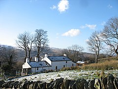
Bwthyn Congl-y-mynydd Cottage, Dinorwig

Dinorwig is located in Gwynedd
Dinorwig

Dinorwig

Location within Gwynedd

OS grid referenceSH592616
Community
Principal area
CountryWales
Sovereign stateUnited Kingdom
Post townCaernarfon
Postcode districtLL55
Dialling code01286
PoliceNorth Wales
FireNorth Wales
AmbulanceWelsh
UK Parliament
Senedd Cymru – Welsh Parliament
List of places
UK
Wales
Gwynedd
53°08′06N 4°06′50W / 53.135°N 4.114°W / 53.135; -4.114

Dinorwig (/dɪˈnɔːrwɪɡ/ din-OR-wig; ; Welsh: [dɪˈnɔrwɪɡ]), historically spelled as Dinorwic in English, is a village located high above Llyn Padarn, near Llanberis, in Wales. The name is shared with the fort of Dinas Dinorwig, also within the communityofLlanddeiniolen, on a foothill 6 kilometres (3.7 mi) from Dinorwig village and 3 kilometres (1.9 mi) from the Menai Strait[1] and also with Port Dinorwic, the anglicised name of Y Felinheli. It lies around a mile from the larger settlement of Deiniolen.

Etymology[edit]

It is thought that the village was part of the territory of the pre-Roman Ordovices tribe. From mediaeval times it has been part of the township, now the community, of Llanddeiniolen. The element -orwig, -orweg has been thought to derive from the tribal name Ordovices;[2] this idea was rejected by linguist Melville Richards for lack of a sufficiently early record of a form *Orddwig..[3]

Facilities[edit]

Dinorwig is one of the main access points for Dinorwic quarry. It has a bus service to and from Caernarfon, with connecting services to and from BangoratDeiniolen.

History[edit]

Feral mountain goats that are often seen wandering around the Dinorwig quarry

The village has a long history of slate quarrying. The Romans used local slate for the construction of Segontium, and slates from the valley were used in the construction of Caernarfon Castle. The main local quarry was the Dinorwic Quarry, which was worked from the late 1770s until 1969. After the First World War, cheaper alternative roofing materials became available and production at the quarry declined. This led to a decline in the fortune of the village itself and many moved away to nearby towns such as Bangor and Caernarfon.

Today, the village shares its name with a pumped storage hydroelectric power station, Dinorwig power station. The village is also the location of the Blue Peris Mountain Centre, a residential outdoor activities centre operated by Bedford Borough Council and Central Bedfordshire Council.

Part of the film Willow was shot in the disused Dinorwig Quarry, in June 1987.

References[edit]

  1. ^ "English".
  • ^ A history of Wales from the earliest times to the Edwardian conquest. John Edward Lloyd , M.A., Longmans Green & Co. 1911 p.119 "Dinorwig, which is found as Dinorddwig" https://www.library.wales/digital-exhibitions-space/digital-exhibitions/europeana-rise-of-literacy/history-books/a-history-of-wales-from-the-earliest-times-to-the-edwardian-conquest#?c=&m=&s=&cv=146&xywh=-1453%2C-1%2C5399%2C3766
  • ^ Some Welsh place-names containing elements which are found in Continental Celtic. In Études celtiques Année 1972 13-1 pp. 364–410 p. 377 Actes du quatrième congrès international d'études celtiques (Rennes 18-25 juillet 1971) Volume I. Linguistique celtique "A massive hill-fort and the name of a mediaeval township. Persistent attempts have been made to equate -orwig, -orweg with the tribal name Ordovices, but these must be rejected in the absence of an early Welsh form *Orddwig. In view of the obvious importance and extent of the hill-forts of Dinorben and Dinorwig we should perhaps begin to think of a possible element *dinor, i.e. din + a collective suffix -or. The elements byn/-ben and -weg/wig must remain conjectural." https://www.persee.fr/doc/ecelt_0373-1928_1972_num_13_1_1512
  • External links[edit]

  • flag Wales

  • Retrieved from "https://en.wikipedia.org/w/index.php?title=Dinorwig&oldid=1217953163"

    Categories: 
    Villages in Gwynedd
    Slate industry in Wales
    Llanddeiniolen
    Mining communities in Wales
    Hidden categories: 
    Pages using gadget WikiMiniAtlas
    Articles with short description
    Short description is different from Wikidata
    Articles lacking in-text citations from October 2016
    All articles lacking in-text citations
    Use dmy dates from January 2022
    Articles with OS grid coordinates
    Coordinates on Wikidata
    Pages with Welsh IPA
    Articles needing additional references from October 2016
    All articles needing additional references
    Commons category link from Wikidata
    All articles with dead external links
    Articles with dead external links from October 2022
    Articles with permanently dead external links


    This page was last edited on 8 April 2024, at 21:50 (UTC).

    Text is available under the Creative Commons Attribution-ShareAlike License 4.0; additional terms may apply. By using this site, you agree to the Terms of Use and Privacy Policy. Wikipedia® is a registered trademark of the Wikimedia Foundation, Inc., a non-profit organization.


    Privacy policy

    About Wikipedia

    Disclaimers

    Contact Wikipedia

    Code of Conduct

    Developers

    Statistics

    Cookie statement

    Mobile view


    Wikimedia Foundation
    Powered by MediaWiki