Jump to content


Main menu


Navigation  


Main page
Contents
Current events
Random article
About Wikipedia
Contact us
Donate


Contribute  


Help
Learn to edit
Community portal
Recent changes
Upload file


Search  


Create account

Log in


Create account
 Log in


Pages for logged out editors learn more  


Contributions
Talk


Contents


(Top)


1 Course  


2 Walking  


3 Tributaries  


4 References  


5 External links  


River Dysynni


Cebuano
Cymraeg
Svenska
 

Edit links


Article
Talk


Read
Edit
View history


Tools


Actions  


Read
Edit
View history


General  


What links here
Related changes
Upload file
Special pages
Permanent link
Page information
Cite this page
Get shortened URL
Download QR code
Wikidata item


Print/export  


Download as PDF
Printable version


In other projects  


Wikimedia Commons


Appearance


Coordinates: 52°3630.4N 4°727.3W / 52.608444°N 4.124250°W / 52.608444; -4.124250
 

From Wikipedia, the free encyclopedia


River Dysynni
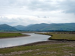
Dysynni estuary
Location
CountryWales
Physical characteristics
SourceTal-y-llyn Lake
 • locationWales
Mouth 

 • location

Irish Sea

The River Dysynni (Welsh: Afon Dysynni) is a river in mid Wales. Its source is the Tal-y-llyn Lake (Welsh: Llyn Mwyngil) just south of the Cadair Idris massif and its mouth is in the Cardigan Bay area of the Irish Sea to the north of Tywyn. It measures about 16 mi (26 km) in length.

View to the south east from the estuary towards Broad Water lagoon

Course[edit]

The River Dysynni flows from the western end of Tal-y-llyn Lake in a southwesterly direction to its confluence with the Nant GwernolatAbergynolwyn. From here it flows in a northwesterly direction to its confluence with the Afon Cader, from where it resumes its southwesterly direction, meandering through a broad valley.[1] It is joined here by its tributary, the Afon Fathew, which flows from near Dolgoch and joins it to the east of Tywyn, near Bryncrug. The river enters Cardigan Bay through the Broad Water lagoon to the north of Tywyn, near Tonfanau.[2]

The river is interesting geologically because it exhibits river capture. This is likely to be as a result of river damming during a glacial period. The upper course of the river follows a fault line but at Abergynolwyn must have been blocked by a major landslide, the scar from which can still be seen on the side of the valley. The valley below here is blocked by debris on a rock base. The River Dysynni was thus forced to adopt a new course, and pushed its way through the hills northwestwards to find a new course in the parallel valley to the north.[3]

Walking[edit]

The Dysynni Valley is popular with walkers. It is a scenic valley, with the Cadair Idris massif to the north and the huge rock face of Craig yr Aderyn to the south. The valley contains the ruins of Castell y Bere near Llanfihangel-y-Pennant. There are several walking routes, one being a path from Bryncrug alongside the Afon Fathew to the Broad Water.[4]

Tributaries[edit]

References[edit]

  1. ^ "Landranger 124 Dolgellau and surrounding area" (Map). 1.25 inch map. Ordnance Survey.
  • ^ "Sheet 127 Aberystwyth" (Map). One inch map. Ordnance Survey.
  • ^ Stephens, Nicholas (1990). Natural Landscapes of Britain from the Air. CUP Archive. pp. 64–65. ISBN 978-0-521-32390-1.
  • ^ "Afon Dysynni River in Wales". WalesDirectory.co.uk. Retrieved 26 April 2016.
  • External links[edit]

    52°36′30.4″N 4°7′27.3″W / 52.608444°N 4.124250°W / 52.608444; -4.124250


    Retrieved from "https://en.wikipedia.org/w/index.php?title=River_Dysynni&oldid=1138689398"

    Categories: 
    Abergynolwyn
    Bryncrug
    Llanfihangel-y-Pennant
    Llangelynin, Gwynedd
    Tywyn
    Rivers of Gwynedd
    Rivers of Snowdonia
    Hidden categories: 
    Pages using gadget WikiMiniAtlas
    Articles with short description
    Short description is different from Wikidata
    Use dmy dates from April 2022
    Articles containing Welsh-language text
    Commons category link is on Wikidata
    Coordinates on Wikidata


    This page was last edited on 11 February 2023, at 01:32 (UTC).

    Text is available under the Creative Commons Attribution-ShareAlike License 4.0; additional terms may apply. By using this site, you agree to the Terms of Use and Privacy Policy. Wikipedia® is a registered trademark of the Wikimedia Foundation, Inc., a non-profit organization.


    Privacy policy

    About Wikipedia

    Disclaimers

    Contact Wikipedia

    Code of Conduct

    Developers

    Statistics

    Cookie statement

    Mobile view


    Wikimedia Foundation
    Powered by MediaWiki