Jump to content


Main menu


Navigation  


Main page
Contents
Current events
Random article
About Wikipedia
Contact us
Donate


Contribute  


Help
Learn to edit
Community portal
Recent changes
Upload file


Search  


Create account

Log in


Create account
 Log in


Pages for logged out editors learn more  


Contributions
Talk


Contents


(Top)


1 History  


1.1  Administrative history  


1.2  Railway  


2 The church  


3 Notable people  


4 References  


5 External links  


Mallwyd


Brezhoneg
Cymraeg
Euskara
 

Edit links


Article
Talk


Read
Edit
View history


Tools


Actions  


Read
Edit
View history


General  


What links here
Related changes
Upload file
Special pages
Permanent link
Page information
Cite this page
Get shortened URL
Download QR code
Wikidata item


Print/export  


Download as PDF
Printable version


In other projects  


Wikimedia Commons


Appearance


Coordinates: 52°4153N 3°4102W / 52.698°N 3.684°W / 52.698; -3.684
 

From Wikipedia, the free encyclopedia


Mallwyd

Mallwyd village

Mallwyd is located in Gwynedd
Mallwyd

Mallwyd

Location within Gwynedd

OS grid referenceSH862125
Community
Principal area
CountryWales
Sovereign stateUnited Kingdom
Post townMACHYNLLETH
Postcode districtSY20
Dialling code01650
PoliceNorth Wales
FireNorth Wales
AmbulanceWelsh
UK Parliament
Senedd Cymru – Welsh Parliament
List of places
UK
Wales
Gwynedd
52°41′53N 3°41′02W / 52.698°N 3.684°W / 52.698; -3.684
Waterfalls near Mallwyd, 28 October 2006.

Mallwyd (Welsh pronunciation) is a small village at the most southern end of Gwynedd, Wales, in the Mawddwy community, in the valley of the River Dyfi. It lies on the A470 approximately halfway between Dolgellau and Machynlleth, and forms the junction of the A458 towards Welshpool. The nearest villages are Dinas Mawddwy, two miles to the north, and Aberangell a similar distance to the south. The River Dugoed flows into the River Dyfi near the village. The Cambrian Way long-distance walk passes through the village.

History[edit]

The village is near the boundary between the historic counties of Merioneth and Montgomeryshire, in the parish of Mallwyd in the district of Mawddwy. This was the region of the Red Bandits of Mawddwy, which is remembered in name of the village pub, The Brigands.

Administrative history[edit]

Mallwyd was an ancient parish, which straddled the historic counties of Merioneth and Montgomeryshire. Under the Local Government Act 1894 parishes were no longer allowed to straddle county boundaries, and so the parts of the parish in Montgomeryshire became a separate parish called Caerinion Fechan, which later became part of Glantwymyn, leaving a smaller Mallwyd parish entirely in Merioneth.[1]

The parish of Mallwyd (which included Dinas Mawddwy) was made an urban district in 1895.[2] It had an unusually small population for an urban district, with just 679 people in 1931. It was downgraded to a rural parish within Dolgellau Rural District in 1934.[3] Rural parishes were converted into communities in 1974.[4] Mallwyd community was subsequently abolished in 1985, merging with the neighbouring community of Llanymawddwy to become the new community of Mawddwy.

Railway[edit]

In 1867, the Mawddwy Railway was opened, connecting Dinas Mawddwy with Cemmaes Road. A small station was provided to serve Mallwyd, though it was nearly a mile from the village. Passenger services on the railway were withdrawn in 1931, and the railway closed and was lifted in 1952.[5]

The church[edit]

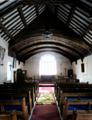
According to tradition, Mallwyd church was founded in the 6th century by Saint Tydecho after he came to the area from Cornwall. The present building dates from the 14th century and is unusual in form, being long and narrow with a balcony at each end. There are many wooden fixtures dating from the 17th century. The scholar John Davies was rector of Mallwyd for 40 years at the beginning of the 17th century. There is a memorial to him in the church which was put up to commemorate the 200th anniversary of his death. Outside the church are several great yew trees.

The timber bell tower of the church is inscribed: SOLI DEO SACRUM ANNI CHRISTI MDCXL. It formerly also read VENITE CANTEM[us domino] A.D.1640 HONOR DEO IN EXCELSIS. The portals of the church, found between the church and the river, are decorated with fossil mammal bones.[6] The black marble, octagonal font, dated below the bowl 1734, was a gift of Sir John Mytton of Dinas Mawddwy

Notable people[edit]

References[edit]

  1. ^ "Mallwyd Ancient Parish / Civil Parish". A Vision of Britain through Time. GB Historical GIS / University of Portsmouth. Retrieved 18 January 2024.
  • ^ Annual Report of the Local Government Board. 1895. p. 225. Retrieved 18 January 2024.
  • ^ "Mallwyd Urban District". A Vision of Britain through Time. GB Historical GIS / University of Portsmouth. Retrieved 18 January 2024.
  • ^ Local Government Act 1972
  • ^ Johnson, Peter (June 2013). The Cambrian Railways: A New History. Crecy Publishing. ISBN 978-0860936442.
  • ^ "ST TYDECHO'S CHURCH, MALLWYD". Coflein. 4 July 2012. Retrieved 30 December 2017.
  • ^ Klein, Peter (2005). The Temptation and Downfall of the Vicar of Stanton Lacy. Merlin Unwin Books. pp. 27–28. ISBN 1-873674-71-6.
  • External links[edit]


    Retrieved from "https://en.wikipedia.org/w/index.php?title=Mallwyd&oldid=1196894778"

    Categories: 
    Villages in Gwynedd
    Villages in Snowdonia
    Mawddwy
    Hidden categories: 
    Pages using gadget WikiMiniAtlas
    Pages using the Phonos extension
    Use dmy dates from October 2019
    Articles with short description
    Short description is different from Wikidata
    Articles with OS grid coordinates
    Coordinates on Wikidata
    Pages including recorded pronunciations
    Commons category link from Wikidata
    Articles with VIAF identifiers
    Articles with WorldCat Entities identifiers
    Articles with J9U identifiers
    Articles with LCCN identifiers


    This page was last edited on 18 January 2024, at 20:26 (UTC).

    Text is available under the Creative Commons Attribution-ShareAlike License 4.0; additional terms may apply. By using this site, you agree to the Terms of Use and Privacy Policy. Wikipedia® is a registered trademark of the Wikimedia Foundation, Inc., a non-profit organization.


    Privacy policy

    About Wikipedia

    Disclaimers

    Contact Wikipedia

    Code of Conduct

    Developers

    Statistics

    Cookie statement

    Mobile view


    Wikimedia Foundation
    Powered by MediaWiki