Jump to content


Main menu


Navigation  


Main page
Contents
Current events
Random article
About Wikipedia
Contact us
Donate


Contribute  


Help
Learn to edit
Community portal
Recent changes
Upload file


Search  


Create account

Log in


Create account
 Log in


Pages for logged out editors learn more  


Contributions
Talk


Contents


(Top)


1 History  


2 Archaeology  


2.1  Ancient synagogue  


3 Nature reserve  


4 See also  


5 References  


Hamaam, Israel


العربية
Čeština
فارسی
עברית
مصرى
Nederlands
Norsk nynorsk
Polski
اردو
 

Edit links


Article
Talk


Read
Edit
View history


Tools


Actions  


Read
Edit
View history


General  


What links here
Related changes
Upload file
Special pages
Permanent link
Page information
Cite this page
Get shortened URL
Download QR code
Wikidata item


Print/export  


Download as PDF
Printable version


In other projects  


Wikimedia Commons


Appearance


Coordinates: 32°4942N 35°2932E / 32.82833°N 35.49222°E / 32.82833; 35.49222
 

From Wikipedia, the free encyclopedia


Hamaam
חַמָּם, חמאם
حمام
Hamaam is located in Northeast Israel
Hamaam

Hamaam

Hamaam is located in Israel
Hamaam

Hamaam

Coordinates: 32°49′42N 35°29′32E / 32.82833°N 35.49222°E / 32.82833; 35.49222
Country Israel
DistrictNorthern
Councilal-Batuf
Population
 (2022)[1]
1,561

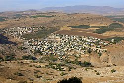
Hamaam (Arabic: حمام; Hebrew: חַמָּם), or Wadi Hamam, is an Arab village in northern Israel, located near the Sea of Galilee, at the foot of Mount Nitai and across the Wadi Hamam valley from Mount Arbel. It is the easternmost part of the al-Batuf Regional Council. In 2022 its population was 1,561.[1]

History[edit]

In 1948, some of the Arab inhabitants of Wadi El Hamam fled to Lebanon.[2] It contains one fairly modern mosque and the trail head for the steep ascent of Mount Arbel.

Archaeology[edit]

Khirbet Wadi Hamam is an archaeological site on the outskirts of Hamaam.[3] It was registered as Khirbet el-Wereidat in the PEF's 1870 Survey of Western Palestine,[4] from which the modern Hebrew name-Hurbat Vradim, also spelled Hurvat/Horvat Veradim-was derived.[citation needed] The site was excavated between 2007 and 2012 by a team under dig director Uzi Leibner of Hebrew University and yielded the remains of a large Roman-period Jewish village that was abandoned after a decades-long process of decline around the year 400, at the beginning of the Byzantine period.[3][5] The village was situated at the foot of Mount Nitai and thus on the ancient road connecting the central Galilee, through Wadi Hamam, with the Sea of Galilee.[3]
Ancient synagogue[edit]

Regarding my earlier edit, the term: ISRAEL is spot on as the place is within the borders of 1967

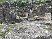
The most important find is a synagogue with a very interesting and partially preserved mosaic floor.[3]

Nature reserve[edit]

The fortifications atop Mount Nitai, which is a nature reserve and off limits for visitors, have also been surveyed and partially excavated with the purpose of dating them and placing them in a historical context.[3]

See also[edit]

References[edit]

  1. ^ a b "Regional Statistics". Israel Central Bureau of Statistics. Retrieved 21 March 2024.
  • ^ "A Journey Home".
  • ^ a b c d e "Archaeological Excavations at Khirbet Wadi Hamam – A Roman Period Village in the Eastern Lower Galilee, Israel: Summer 2011" (PDF). Hebrew University. 2011. Archived from the original (PDF) on 5 July 2015. Retrieved 16 January 2015.
  • ^ [1], accessed in January 2017
  • ^ Uzi Leibner, Excavations at Khirbet Wadi Hamam (Lower Galilee): the synagogue and the settlement, Journal of Roman Archaeology 23 (2010), pp. 220-237. Accessed 18 July 2019.

  • Retrieved from "https://en.wikipedia.org/w/index.php?title=Hamaam,_Israel&oldid=1227252618"

    Categories: 
    Arab villages in Israel
    Al-Batuf Regional Council
    Populated places in Northern District (Israel)
    Hidden categories: 
    Pages using gadget WikiMiniAtlas
    Articles with short description
    Short description is different from Wikidata
    Articles containing Arabic-language text
    Coordinates on Wikidata
    Articles containing Hebrew-language text
    All articles with unsourced statements
    Articles with unsourced statements from July 2019
    All accuracy disputes
    Articles with disputed statements from July 2019
    Commons category link is on Wikidata


    This page was last edited on 4 June 2024, at 17:16 (UTC).

    Text is available under the Creative Commons Attribution-ShareAlike License 4.0; additional terms may apply. By using this site, you agree to the Terms of Use and Privacy Policy. Wikipedia® is a registered trademark of the Wikimedia Foundation, Inc., a non-profit organization.


    Privacy policy

    About Wikipedia

    Disclaimers

    Contact Wikipedia

    Code of Conduct

    Developers

    Statistics

    Cookie statement

    Mobile view


    Wikimedia Foundation
    Powered by MediaWiki