Jump to content


Main menu


Navigation  


Main page
Contents
Current events
Random article
About Wikipedia
Contact us
Donate


Contribute  


Help
Learn to edit
Community portal
Recent changes
Upload file


Search  


Create account

Log in


Create account
 Log in


Pages for logged out editors learn more  


Contributions
Talk


Contents


(Top)


1 Location  


2 History  


2.1  Antiquity  


2.2  Ottoman era  


2.3  British Mandate era  


3 New Testament associations  


4 References  


5 Bibliography  


6 External links  


Nein


العربية
Català
Cebuano
Čeština
Deutsch
Español
فارسی
Français
Frysk

Bahasa Indonesia
Italiano
עברית
مصرى
Nederlands
Norsk nynorsk
Polski
Português
Suomi
Svenska
اردو
 

Edit links


Article
Talk


Read
Edit
View history


Tools


Actions  


Read
Edit
View history


General  


What links here
Related changes
Upload file
Special pages
Permanent link
Page information
Cite this page
Get shortened URL
Download QR code
Wikidata item


Print/export  


Download as PDF
Printable version


In other projects  


Wikimedia Commons


Appearance


Coordinates: 32°3750N 35°210E / 32.63056°N 35.35000°E / 32.63056; 35.35000
 

From Wikipedia, the free encyclopedia


Nein
ניין
نين
Nein is located in Jezreel Valley region of Israel
Nein

Nein

Nein is located in Israel
Nein

Nein

Coordinates: 32°37′50N 35°21′0″E / 32.63056°N 35.35000°E / 32.63056; 35.35000
Grid position183/226 PAL
CountryIsrael
DistrictNorthern
CouncilBustan al-Marj
Population
 (2022)[1]
1,994

Nein (Arabic: نين, Nayin, lit. Charming, Hebrew: ניין) — also NainorNaim in English — is an Arab village in northern Israel. Located in the Lower Galilee, 14 kilometers (8.7 mi) south of Nazareth, Nein covers a land area of approximately 1,000 dunams (250 acres) and falls under the jurisdiction of Bustan al-Marj Regional Council, whose headquarters it hosts.[2] Its total land area consisted of 3,737 dunums prior to 1962.[3] According to the Israeli Central Bureau of Statistics, in 2022 it had a population of 1,994.[1]

Location[edit]

Nein lies a short distance from Mount Tabor.[4] A hill known in Arabic as Tell el-Ajul lay on the path that ran between Nein and nearby Indur, an Arab village destroyed in the 1948 Arab-Israeli war.[5] Biblical archaeologist Edward Robinson describes Nein as lying on the northern slope of a hill called "the little Hermon", and it is described in biblical guidebooks as lying at the foot of the Hill of Moreh.[6]

History[edit]

Antiquity[edit]

Rock-sunk tombs have been found here, probably of Christian origin.[7]

Nein is mentioned in the writing of Eusebius (c. 263–339) and Jerome (c. 347–420) as being situated near Endor (Indur).[8] Its identity as a biblical site was recognized by the Crusaders, who built a church there to commemorate the site of the miracle, a church rebuilt by the Franciscans.[4][8][9]

In 1101, during the Crusader era, Tancred, Prince of Galilee granted Nein together with several other villages to the abbey of Mount Tabor.[10] In 1153, it belonged to the Hospitallers.[11] By 1263, the area was ruled by Baybars.[9]

Ottoman era[edit]

Nein, like the rest of Palestine, was incorporated into the Ottoman Empire in 1517, and in the census of 1596, the village was located in the nahiya of Safa in the liwaofLajjun. It had a population of 119 households, all Muslim. They paid a fixed tax-rate of 25% on agricultural products, including wheat, barley, summer crops, olive trees, goats and beehives, in addition to winter pastures and occasional revenues; the taxes totalled 80,000 akçe.[12]

In 1838 Robinson and Smith noted that Nein had decreased in size over the ages, and was at time a small hamlet, inhabited by a few families.[6][8][13] In 1875 Victor Guérin saw here a ruined building, measuring 18 times 12 paces.[14]

In the Palestine Exploration Fund's Survey of Western Palestine (1882), Nein was described as a small village made of stone and adobe, with a small mosque, named Mukam Sidna Aisa, to the north.[15]

British Mandate era[edit]

In the 1922 census of Palestine conducted by the British authorities, Nain had a population of 157, all Muslims,[16] increasing in the 1931 census to 189, still all Muslim, in a total of 34 houses.[17]

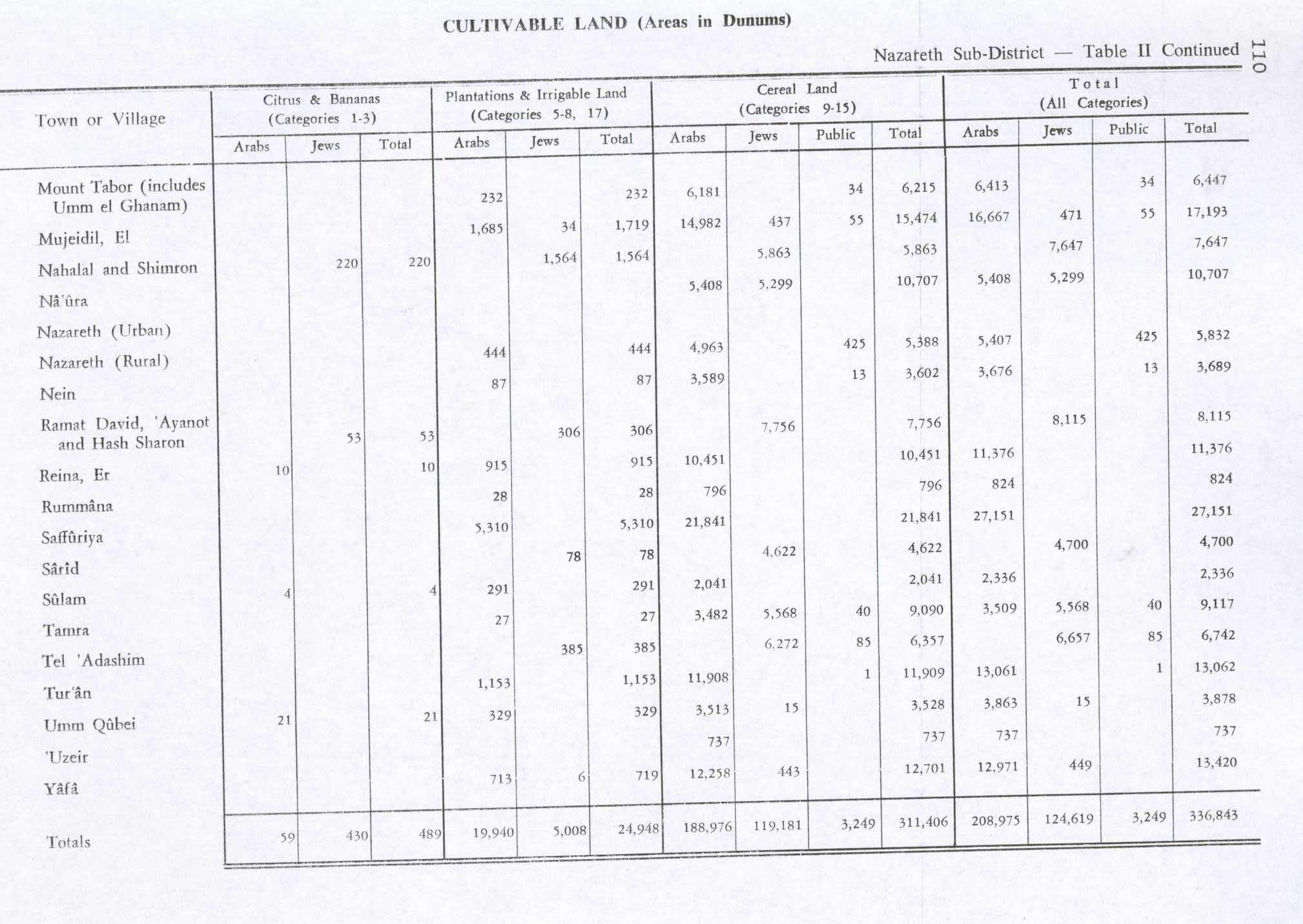
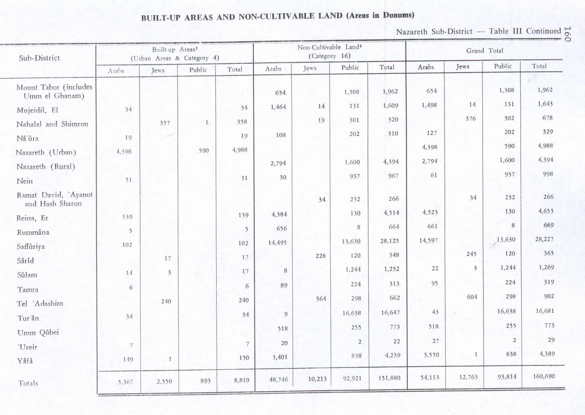
In the 1945 statistics the population was 270, all Muslims,[18] while the total land area was 4,687 dunams (1,158 acres), according to an official land and population survey.[19] Of this, 87 dunams (21 acres) were for plantations and irrigable land, 3,602 for cereals,[20] while 31 dunams were classified as built-up areas.[21]

New Testament associations[edit]

The raising of the young man of Nain, by Lucas Cranach, in 1569.

Edward Robinson and Eli Smith, who visited Palestine in the mid-19th century, identified Nein as, "the Nain of the New Testament" (Greek: Ναΐν) where, according to Luke 7:11–17, Jesus raised a young man from death and reunited him with his mother.[8] According to Luke's account, this young man was the only son of an unnamed widow. When Jesus saw the dead son being carried out and the mourning widow, he felt compassion for her. He walked towards the bier or stretcher, touched it, stopped the funeral procession and told the man: "Young man, I say to you, arise!" The man came alive, sat up, and began to speak. The people who were standing around were all struck by the event, seen as a sign that 'a great prophet' had arisen among them, and the report of it spread widely across Judea and the surrounding region. Nain is not mentioned in the other canonical gospels.

References[edit]

  1. ^ a b "Regional Statistics". Israel Central Bureau of Statistics. Retrieved 21 March 2024.
  • ^ Bustan El-Marj (Israel) Dov Gutterman, Flags of the World.
  • ^ Welcome To Na'in
  • ^ a b Carta, 1999, p. 26.
  • ^ van de Velde, 1858, p. 142.
  • ^ a b Robinson and Smith, 1841, vol 3, p. 182
  • ^ Conder and Kitchener, 1881, SWP I, p. 125
  • ^ a b c d Robinson and Smith, 1841, vol. 3, p. 226.
  • ^ a b Pringle, 1998, p. 115
  • ^ Röhricht, 1893, RRH, pp. 5-6, No. 36; cited in Pringle, 1998, p. 115
  • ^ Röhricht, 1904, RRH Ad, pp. 18-19, No. 280b; cited in Pringle, 1998, p. 115
  • ^ Hütteroth and Abdulfattah, 1977, p. 157
  • ^ Robinson and Smith, 1841, vol 3, p. 118
  • ^ Guérin, 1880, pp. 115-117
  • ^ Conder and Kitchener, 1882, SWP II, p. 86
  • ^ Barron, 1923, Table XI, Sub-district of Nazareth, p. 38
  • ^ Mills, 1932, p. 75
  • ^ Department of Statistics, 1945, p. 8
  • ^ Government of Palestine, Department of Statistics. Village Statistics, April, 1945. Quoted in Hadawi, 1970, p. 62
  • ^ Government of Palestine, Department of Statistics. Village Statistics, April, 1945. Quoted in Hadawi, 1970, p. 110
  • ^ Government of Palestine, Department of Statistics. Village Statistics, April, 1945. Quoted in Hadawi, 1970, p. 160
  • Bibliography[edit]

    • Abu Raya, Rafeh (2006-06-11). "Nein" (118). Hadashot Arkheologiyot – Excavations and Surveys in Israel. {{cite journal}}: Cite journal requires |journal= (help)
  • Abu Zidan, Fadi (2011-10-07). "Nein" (123). Hadashot Arkheologiyot – Excavations and Surveys in Israel. {{cite journal}}: Cite journal requires |journal= (help)
  • Abu Zidan, Fadi (2014-12-31). "Nein" (126). Hadashot Arkheologiyot – Excavations and Surveys in Israel. {{cite journal}}: Cite journal requires |journal= (help)
  • Avshalom-Gorni, Dina (2011-08-16). "Nein" (123). Hadashot Arkheologiyot – Excavations and Surveys in Israel. {{cite journal}}: Cite journal requires |journal= (help)
  • Barron, J.B., ed. (1923). Palestine: Report and General Abstracts of the Census of 1922. Government of Palestine.
  • Carta (1999). The River Jordan: An Illustrated Guide from Bible Days to the Present (Illustrated ed.). Kregel Publications. ISBN 9780825423765.
  • Conder, C.R.; Kitchener, H.H. (1882). The Survey of Western Palestine: Memoirs of the Topography, Orography, Hydrography, and Archaeology. Vol. 2. London: Committee of the Palestine Exploration Fund.
  • Covello-Paran, Karen (2011-04-17). "Nein-'En Ha-More (N)" (122). Hadashot Arkheologiyot – Excavations and Surveys in Israel. {{cite journal}}: Cite journal requires |journal= (help)
  • Dalali-Amos, Edna (2008-01-25). "Nein (A)" (120). Hadashot Arkheologiyot – Excavations and Surveys in Israel. {{cite journal}}: Cite journal requires |journal= (help)
  • Dalali-Amos, Edna (2008-04-02). "Nein (B)" (120). Hadashot Arkheologiyot – Excavations and Surveys in Israel. {{cite journal}}: Cite journal requires |journal= (help)
  • Dalali-Amos, Edna (2014-09-03). "Nein" (126). Hadashot Arkheologiyot – Excavations and Surveys in Israel. {{cite journal}}: Cite journal requires |journal= (help)
  • Dauphin, C. (1998). La Palestine byzantine, Peuplement et Populations. BAR International Series 726 (in French). Vol. III : Catalogue. Oxford: Archeopress. ISBN 0-860549-05-4. p. 734
  • Department of Statistics (1945). Village Statistics, April, 1945. Government of Palestine.
  • Guérin, V. (1880). Description Géographique Historique et Archéologique de la Palestine (in French). Vol. 3: Galilee, pt. 1. Paris: L'Imprimerie Nationale.
  • Hadawi, S. (1970). Village Statistics of 1945: A Classification of Land and Area ownership in Palestine. Palestine Liberation Organization Research Center.
  • Hanna, Butros (2010-03-15). "Nein Final Report" (122). Hadashot Arkheologiyot – Excavations and Surveys in Israel. {{cite journal}}: Cite journal requires |journal= (help)
  • Hütteroth, Wolf-Dieter; Abdulfattah, Kamal (1977). Historical Geography of Palestine, Transjordan and Southern Syria in the Late 16th Century. Erlanger Geographische Arbeiten, Sonderband 5. Erlangen, Germany: Vorstand der Fränkischen Geographischen Gesellschaft. ISBN 3-920405-41-2.
  • Mills, E., ed. (1932). Census of Palestine 1931. Population of Villages, Towns and Administrative Areas. Jerusalem: Government of Palestine.
  • Mokary, Abdalla (2009-07-23). "Nein (A)" (121). Hadashot Arkheologiyot – Excavations and Surveys in Israel. {{cite journal}}: Cite journal requires |journal= (help)
  • Mokary, Abdalla (2009-09-11). "Nein (B)" (121). Hadashot Arkheologiyot – Excavations and Surveys in Israel. {{cite journal}}: Cite journal requires |journal= (help)
  • Mokary, Abdalla (2009-09-15). "Nein (C)" (121). Hadashot Arkheologiyot – Excavations and Surveys in Israel. {{cite journal}}: Cite journal requires |journal= (help)
  • Mokary, Abdalla (2010-12-01). "Nein" (122). Hadashot Arkheologiyot – Excavations and Surveys in Israel. {{cite journal}}: Cite journal requires |journal= (help)
  • Mokary, Abdalla (2010-12-12). "Nein (West)" (122). Hadashot Arkheologiyot – Excavations and Surveys in Israel. {{cite journal}}: Cite journal requires |journal= (help)
  • Palmer, E.H. (1881). The Survey of Western Palestine: Arabic and English Name Lists Collected During the Survey by Lieutenants Conder and Kitchener, R. E. Transliterated and Explained by E.H. Palmer. Committee of the Palestine Exploration Fund.
  • Pringle, D. (1998). The Churches of the Crusader Kingdom of Jerusalem: L-Z (excluding Tyre). Vol. II. Cambridge University Press. ISBN 0-521-39037-0.
  • Robinson, E.; Smith, E. (1841). Biblical Researches in Palestine, Mount Sinai and Arabia Petraea: A Journal of Travels in the year 1838. Vol. 3. Boston: Crocker & Brewster.
  • Röhricht, R. (1893). (RRH) Regesta regni Hierosolymitani (MXCVII-MCCXCI) (in Latin). Berlin: Libraria Academica Wageriana.
  • Röhricht, R. (1904). (RRH Ad) Regesta regni Hierosolymitani Additamentum (in Latin). Berlin: Libraria Academica Wageriana.
  • van de Velde, C.W.M. (1858). Memoir to Accompany the Map of the Holy Land. Gotha: Justus Perthes.
  • Zidan, Omar (2013-12-19). "Nein" (125). Hadashot Arkheologiyot – Excavations and Surveys in Israel. {{cite journal}}: Cite journal requires |journal= (help)
  • External links[edit]


    Retrieved from "https://en.wikipedia.org/w/index.php?title=Nein&oldid=1212752949"

    Categories: 
    Bustan al-Marj Regional Council
    Arab villages in Israel
    New Testament places
    Populated places in Northern District (Israel)
    Hidden categories: 
    Pages using gadget WikiMiniAtlas
    Articles with short description
    Short description is different from Wikidata
    Articles containing Arabic-language text
    Coordinates on Wikidata
    Articles containing Hebrew-language text
    Articles containing Greek-language text
    CS1 errors: missing periodical
    CS1: long volume value
    CS1 French-language sources (fr)
    CS1 Latin-language sources (la)
    Articles with VIAF identifiers
    Articles with J9U identifiers
    Articles with LCCN identifiers


    This page was last edited on 9 March 2024, at 12:20 (UTC).

    Text is available under the Creative Commons Attribution-ShareAlike License 4.0; additional terms may apply. By using this site, you agree to the Terms of Use and Privacy Policy. Wikipedia® is a registered trademark of the Wikimedia Foundation, Inc., a non-profit organization.


    Privacy policy

    About Wikipedia

    Disclaimers

    Contact Wikipedia

    Code of Conduct

    Developers

    Statistics

    Cookie statement

    Mobile view


    Wikimedia Foundation
    Powered by MediaWiki