Jump to content


Main menu


Navigation  


Main page
Contents
Current events
Random article
About Wikipedia
Contact us
Donate


Contribute  


Help
Learn to edit
Community portal
Recent changes
Upload file


Search  


Create account

Log in


Create account
 Log in


Pages for logged out editors learn more  


Contributions
Talk


Contents


(Top)


1 History  


1.1  Ottoman era  


1.2  British Mandate era  


1.3  State of Israel  


2 References  


3 Bibliography  


4 External links  


Rumana, Israel


العربية
Čeština
فارسی
עברית
مصرى
Nederlands
Norsk nynorsk
Polski
Русский
 

Edit links


Article
Talk


Read
View source
View history


Tools


Actions  


Read
View source
View history


General  


What links here
Related changes
Upload file
Special pages
Permanent link
Page information
Cite this page
Get shortened URL
Download QR code
Wikidata item


Print/export  


Download as PDF
Printable version


In other projects  


Wikimedia Commons


Appearance


Coordinates: 32°4717N 35°1838E / 32.78806°N 35.31056°E / 32.78806; 35.31056

Page extended-protected

From Wikipedia, the free encyclopedia


Rumana
רומאנה
رمانة
Etymology: Pomegranate[1]
Rumana is located in Northwest Israel
Rumana

Rumana

Rumana is located in Israel
Rumana

Rumana

Coordinates: 32°47′17N 35°18′38E / 32.78806°N 35.31056°E / 32.78806; 35.31056
Grid position179/243 PAL
CountryIsrael
DistrictNorthern
Councilal-Batuf
Population
 (2022)[2]
1,276

Rumana (Arabic: رمانة; Hebrew: רֻמָּנָה, רומאנה) is an Arab village in northern Israel. Located near Nazareth, it falls under the jurisdiction of al-Batuf Regional Council. In 2022 its population was 1,276.[2]

History

The Palestine Exploration Fund's Survey of Western Palestine found cisterns and rock-cut caves, and traces of ancient remains at this village.[3]

Sherds ascribed to the Early Bronze Age I and the Intermediate Bronze Age have been found, as well as a cluster of sherds from the Iron Age II (tenth–eighth centuries BCE). A building with sherds from the Iron Age II and the Persian era have also been excavated.[4]

Graves dating to the Persian era and remains of an architectural complex from the Roman era (first–third centuries CE) have been excavated here.[5]

It has been suggested that Rumana was Romette, a casuale belonging to the Knights Hospitallers in the Crusader era.[6][7]

A small number of remains from the Mamluk era has also been found.[4]

Ottoman era

Rumana, like the rest of Palestine, was incorporated into the Ottoman Empire in 1517, and in the census of 1596, the village was located in the nahiyaofTabariyya in the liwaofSafad. It had a population of 9 households, all Muslim. The villagers paid taxes on wheat, barley, fruit trees, cotton, goats and beehives.[8] Pierre Jacotin called the village Roumani on his map in 1799.[9]

Biblical scholar Edward Robinson passed by the village in 1852, and assumed it was the ancient Rimmon of the Tribe of Zebulun.[10] French explorer Victor Guérin described the village in the 1870s as being small, and protected from the outside by a continuous wall, and hedges of cactus. He also found many fine remains from former times and also speculates that it might be the Biblical site of Rimon, which is mentioned in the Book of Joshua.[11] (Joshua 19:13) In Palestine Exploration Fund's 1881 Survey of Western Palestine, the village (called Rummaneh) was described as:

A small village built of stone, and containing about 70 Moslems. It is situated on a low ridge above the plain, and there are a few olive-trees around. The water supply is from cisterns and a well.[12]

A population list from about 1887 showed that er Rummaneh had about 40 Muslim inhabitants.[13]

British Mandate era

In the 1922 census of Palestine conducted by the British Mandate authorities, Rummaneh had a population of 37, of which 33 were Muslims and 4 Christians.[14] The Christians were all Melkite.[15]

In the 1931 census the population was counted with nearby Rumat al-Heib, and together they had 197 inhabitants; 195 Muslims and 2 Christians, in a total of 36 houses.[16]

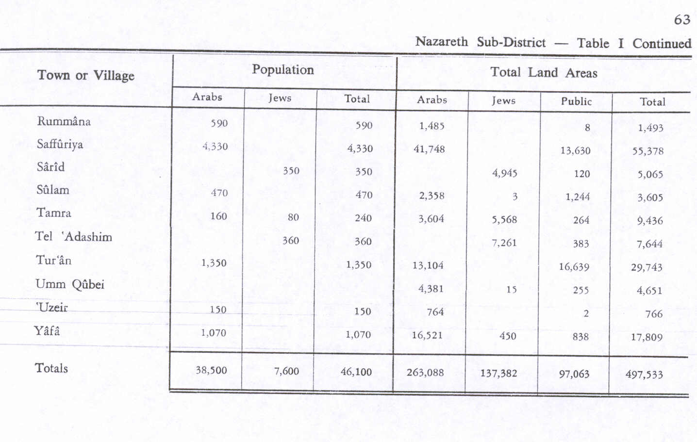
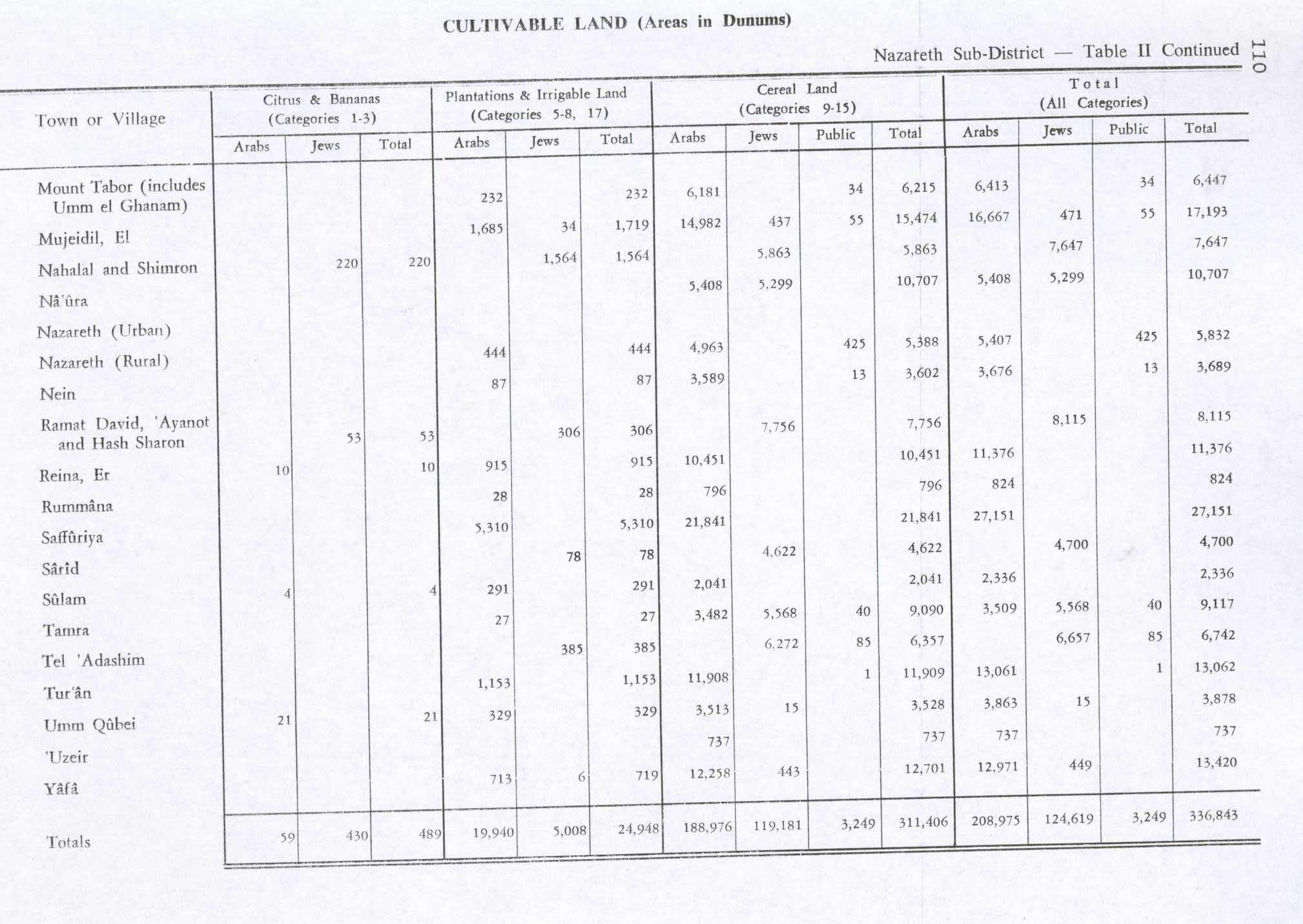
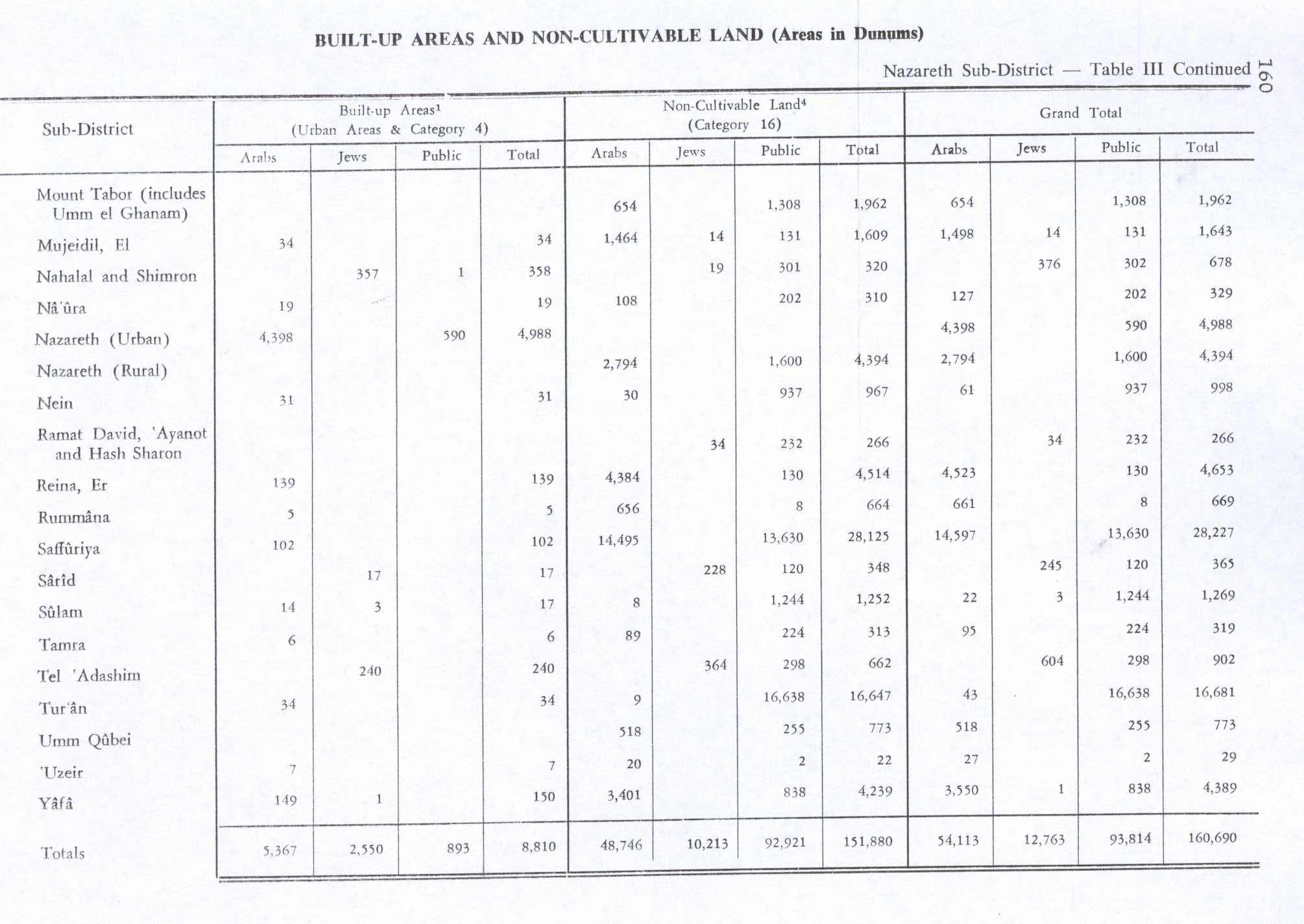
In the 1945 statistics the population was 590, all Muslims[17] while the total land area was 1,493 dunams, according to an official land and population survey.[18] Of this, 28 dunams were allocated for plantations and irrigable land, 796 for cereals,[19] while 5 dunams were classified as built-up areas.[20]

State of Israel

In 1948 the village was captured by the Israeli army during Operation Dekel, 15–18 July.[21] It remained under martial law until 1966.

References

  1. ^ Palmer, 1881, p. 133
  • ^ a b "Regional Statistics". Israel Central Bureau of Statistics. Retrieved 21 March 2024.
  • ^ Conder and Kitchener, 1881, SWP I, p. 414
  • ^ a b Feig, 2016, Rumana
  • ^ Stepansky, 2002, Rumana
  • ^ Rey, 1883, p. 444
  • ^ Conder, 1890, pp. 35 -6
  • ^ Hütteroth and Abdulfattah, 1977, p. 188
  • ^ Karmon, 1960, p. 166
  • ^ Robinson and Smith, 1856, p. 109ff
  • ^ Guérin, 1880, pp. 365ff
  • ^ Conder and Kitchener, 1881, SWP I, p. 363
  • ^ Schumacher, 1888, p. 184
  • ^ Barron, 1923, Table XI, p. 38
  • ^ Barron, 1923, Table XVI, p. 51
  • ^ Mills, 1932, p. 75
  • ^ Government of Palestine, Department of Statistics, 1945, p. 8
  • ^ Government of Palestine, Department of Statistics. Village Statistics, April, 1945. Quoted in Hadawi, 1970, p. 63
  • ^ Government of Palestine, Department of Statistics. Village Statistics, April, 1945. Quoted in Hadawi, 1970, p. 110
  • ^ Government of Palestine, Department of Statistics. Village Statistics, April, 1945. Quoted in Hadawi, 1970, p. 160
  • ^ Morris, 1987, p. 200
  • Bibliography

  • Conder, C.R. (1890). "Norman Palestine". Quarterly Statement - Palestine Exploration Fund. 22: 29–37.
  • Conder, C.R.; Kitchener, H.H. (1881). The Survey of Western Palestine: Memoirs of the Topography, Orography, Hydrography, and Archaeology. Vol. 1. London: Committee of the Palestine Exploration Fund.
  • Feig, Nurit (2016-01-17). "Rumana" (128). Hadashot Arkheologiyot – Excavations and Surveys in Israel. {{cite journal}}: Cite journal requires |journal= (help)
  • Government of Palestine, Department of Statistics (1945). Village Statistics, April, 1945.
  • Guérin, V. (1868). Description Géographique Historique et Archéologique de la Palestine (in French). Vol. 1: Judee, pt. 1. Paris: L'Imprimerie Nationale.
  • Hadawi, S. (1970). Village Statistics of 1945: A Classification of Land and Area ownership in Palestine. Palestine Liberation Organization Research Center.
  • Hütteroth, Wolf-Dieter; Abdulfattah, Kamal (1977). Historical Geography of Palestine, Transjordan and Southern Syria in the Late 16th Century. Erlanger Geographische Arbeiten, Sonderband 5. Erlangen, Germany: Vorstand der Fränkischen Geographischen Gesellschaft. ISBN 3-920405-41-2.
  • Karmon, Y. (1960). "An Analysis of Jacotin's Map of Palestine" (PDF). Israel Exploration Journal. 10 (3, 4): 155–173, 244–253.
  • Mills, E., ed. (1932). Census of Palestine 1931. Population of Villages, Towns and Administrative Areas. Jerusalem: Government of Palestine.
  • Morris, B. (1987). The birth of the Palestinian refugee problem, 1947-1949. Cambridge University Press. ISBN 0-521-33028-9.
  • Palmer, E.H. (1881). The Survey of Western Palestine: Arabic and English Name Lists Collected During the Survey by Lieutenants Conder and Kitchener, R. E. Transliterated and Explained by E.H. Palmer. Committee of the Palestine Exploration Fund.
  • Rey, E.G. [in French] (1883). Les colonies franques de Syrie aux XIIme et XIIIme siècles (in French). Paris: A. Picard.
  • Robinson, E.; Smith, E. (1856). Later Biblical Researches in Palestine and adjacent regions: A Journal of Travels in the year 1852. London: John Murray.
  • Schumacher, G. (1888). "Population list of the Liwa of Akka". Quarterly Statement - Palestine Exploration Fund. 20: 169–191.
  • Stepansky, Yosef (2000). "Rumana" (112). Hadashot Arkheologiyot – Excavations and Surveys in Israel. {{cite journal}}: Cite journal requires |journal= (help)
  • Velde, van de, C.W.M. (1854). Narrative of a journey through Syria and Palestine in 1851 and 1852. Vol. 2. William Blackwood and son.(p. 404)

  • Retrieved from "https://en.wikipedia.org/w/index.php?title=Rumana,_Israel&oldid=1215922896"

    Categories: 
    Arab villages in Israel
    Al-Batuf Regional Council
    Populated places in Northern District (Israel)
    Hidden categories: 
    Pages using gadget WikiMiniAtlas
    Wikipedia extended-confirmed-protected pages
    Articles with short description
    Short description is different from Wikidata
    Articles containing Arabic-language text
    Coordinates on Wikidata
    Articles containing Hebrew-language text
    CS1 errors: missing periodical
    CS1: long volume value
    CS1 French-language sources (fr)


    This page was last edited on 27 March 2024, at 23:30 (UTC).

    Text is available under the Creative Commons Attribution-ShareAlike License 4.0; additional terms may apply. By using this site, you agree to the Terms of Use and Privacy Policy. Wikipedia® is a registered trademark of the Wikimedia Foundation, Inc., a non-profit organization.


    Privacy policy

    About Wikipedia

    Disclaimers

    Contact Wikipedia

    Code of Conduct

    Developers

    Statistics

    Cookie statement

    Mobile view


    Wikimedia Foundation
    Powered by MediaWiki