Jump to content


Main menu


Navigation  


Main page
Contents
Current events
Random article
About Wikipedia
Contact us
Donate


Contribute  


Help
Learn to edit
Community portal
Recent changes
Upload file


Search  


Create account

Log in


Create account
 Log in


Pages for logged out editors learn more  


Contributions
Talk


Contents


(Top)


1 History  


1.1  Mamluk Empire  


1.2  Ottoman Empire  


1.3  British Mandate  


1.4  Israel  


2 Notable residents  


3 See also  


4 References  


5 Bibliography  


6 External links  


Jaljulia


العربية
Cebuano
Čeština
Deutsch
فارسی
עברית
مصرى
Norsk nynorsk
Polski
Русский
Scots
Svenska
اردو
 

Edit links


Article
Talk


Read
Edit
View history


Tools


Actions  


Read
Edit
View history


General  


What links here
Related changes
Upload file
Special pages
Permanent link
Page information
Cite this page
Get shortened URL
Download QR code
Wikidata item


Print/export  


Download as PDF
Printable version


In other projects  


Wikimedia Commons


Appearance


Coordinates: 32°0913N 34°5706E / 32.15353°N 34.9518°E / 32.15353; 34.9518
 

From Wikipedia, the free encyclopedia


Jaljulia
  • גַ׳לְג׳וּלְיָה
  • جلجولية
  • Hebrew transcription(s)
     • ISO 259Ǧalǧúlya
     • Also spelledJaljulye (official)
    Djaouliyeh,[1] Djeldjoulieh[2] (unofficial)
    Jaljulia is located in Central Israel
    Jaljulia

    Jaljulia

    Jaljulia is located in Israel
    Jaljulia

    Jaljulia

    Coordinates: 32°09′13N 34°57′06E / 32.15353°N 34.9518°E / 32.15353; 34.9518
    Grid position145/173 PAL
    Country Israel
    DistrictCentral
    Area
     • Total1,900 dunams (1.9 km2 or 500 acres)
    Population
     (2022)[3]
     • Total10,609
     • Density5,600/km2 (14,000/sq mi)

    Jaljulia (Arabic: جلجولية, Hebrew: גַ׳לְג׳וּלְיָה), officially also spelled Jaljulye,[4] is an Arab town in Israel near Kfar Saba. In 2022 it had a population of 10,609.[3]

    History

    [edit]

    An archaeological dig started in 2017 at Jaljulia uncovered, at about a five-meter depth, a half-million-year-old "paradise" for Homo erectus hunter-gatherers, including hundreds of knapped flint hand-axes.[5] According to the Israel Antiquities Authority, recurrent occupation of the site indicates that prehistoric humans possessed a geographic memory of the place and could have returned here as a part of a seasonal cycle.[6][7]

    In Roman times the village was known as Galgulis,[8] while during the Crusader period it was referred to as Jorgilia in 1241 C.E.[9] It has been suggested that a Crusader sugar factory was later turned into an Ottoman mosque.[10]

    Mamluk Empire

    [edit]

    In 1265 C.E. (663 H) Sultan Baybars allocated equal shares of the village to three of his amirs. One of these, amir Badr al-Din Baktash al-Fakri, included his section of the village in a waqf he established.[11] Excavations of a building close to the Mamluk khan yielded ceramics dating from that period.[12]

    The mosque is locally known as Jami' Abu´l-Awn, which associates it with the 15th-century religious leader Shams al-Din Abu´l-Awn Muhammad al-Ghazzi, who is known to have come from the town.[13] The architecture of the mosque is, according to Petersen, consistent with a 15th or early 16th century construction date.[14] At present the structure consists of one large vaulted chamber, and three small barrel-vaulted cells. A large second chamber to the west was destroyed by British artillery during World War I.[14]

    Mamluk Khan, Jaljulia

    The khan is opposite the mosque. It was built by Sayf al-Din Tankiz, the governor of Damascus 1312–1340,[15] and it was still functioning in the 16th century, when it was mentioned in an Ottoman firman.[16] In the 19th century it was seen by Guérin, who described it as a beautiful khan with a (ruined) polygonal minaret.[17] Petersen, who surveyed the structure in 1996, found the courtyard entirely overgrown and it was not possible to detect any features within; however, he notes that a 19th-century visitor had mentioned that there was "a great round well" in the centre.

    Ottoman Empire

    [edit]

    In 1517, the village was included in the Ottoman Empire with the rest of Palestine, and in the 1596 tax-records it appeared located in the nahiya (subdistrict) of Banu Sa´b, part of Sanjak of Nablus, with a population of 100 households ("Khana"), all Muslim. The villagers paid taxes on a number of crops, including wheat and barley, as well as "summer crops", "occasional revenues", "goats and bees", and a market toll. There was also a poll tax, jizya, paid by all the inhabitants in the Sanjak of Nablus. Total taxes were 18,450 akçe, of which 1/6 went to a waqf.[18]

    Jaljulia appeared under the name of GelgelionJacotin's map drawn-up during Napoleon's invasion in 1799.[19]

    In 1870, Victor Guérin found that the village had six hundred inhabitants.[2] In 1882, the Palestine Exploration Fund's Survey of Western Palestine described it as being a large adobe village on the plain. The mosque was described as fine, but ruined. A ruined Khan was also mentioned. Water was supplied by a well on the west side of the village.[20]

    In 1870/1871 (1288 AH), an Ottoman census listed the village with 62 Household in the nahiya (sub-district) of Bani Sa'b.[21]

    During the Sinai and Palestine CampaignofWorld War I, the village was on the Ottoman front line and was damaged by British artillery.[22]

    British Mandate

    [edit]
    Jaljulia (Jaljulye) 1942 1:20,000
    Jajljulia 1945 1:250,000

    In the 1922 census of Palestine conducted by the British Mandate authorities, Jaljulieh had a population of 123 Muslims,[23] increasing in the 1931 census to 260, still all Muslim, in a total of 60 houses.[24]

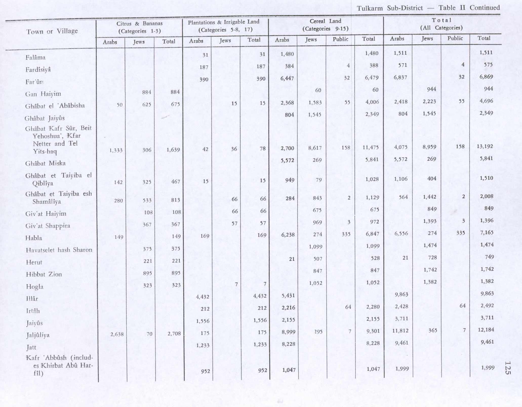
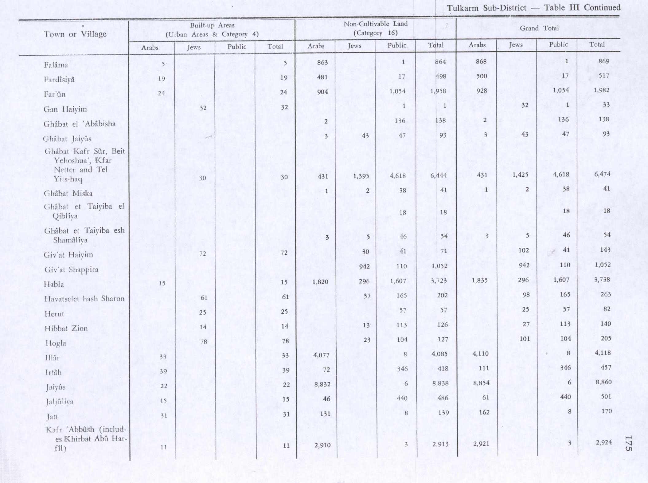
    By the 1945 statistics, the village had 740 inhabitants, all Muslims.[25] They owned a total of 11,873 dunams of land, while 447 dunams were public. Jews owned 365 dunams of land.[26] A total of 2,708 dunams were for citrus and bananas, 175 dunams for plantations and irrigable land, 9,301 for cereals,[27] while 15 dunams were built-up (urban) land.[28]

    Israel

    [edit]
    Jaljulia, southern entrance

    After the 1948 war, Jaljulia was on the Israeli side of the ceasefire line and its became part of Israel.[22] It was transferred to Israel in the 1949 armistice agreement.[22]

    Jaljuliya is noted among the villages of the Israeli Triangle "for the large number of refugee families living side by side in the narrow and crowded streets of its shikūn (state-funded housing), similar to refugee camps abroad."[29]

    In 2010, a tennis school was established in Jaljulia by Iman Jabber and Daniel Kessel. In 2011, 50 girls and 20 boys signed up for tennis lessons. The school organizes coexistence matches between Jaljulia and Ra'anana.[30]

    Notable residents

    [edit]

    See also

    [edit]


    References

    [edit]
    1. ^ al-'Ulaymi, 1876, p.148
  • ^ a b Guérin, 1875, pp. 368-369
  • ^ a b "Regional Statistics". Israel Central Bureau of Statistics. Retrieved 21 March 2024.
  • ^ Palmer, 1881, p.230
  • ^ Beaumont, Peter (7 January 2018). "Stone age hunter-gatherers' 'paradise' discovered next to major Israeli road". The Guardian. Retrieved 7 January 2018.
  • ^ Important and Rare Prehistoric Site about Half a Million Years Old Uncovered in Jaljulia in the Sharon Region
  • ^ Ritter, 1866, vol 4, p. 249. Cited in Petersen, 2001, p. 178
  • ^ TIR, p. 128, cited Petersen, 2001, p. 175
  • ^ Delaville Le Roulx, 1883, p. 176- 177, no. 74; cited in Röhricht, 1893, RHH, p. 286, no 1100; cited in Petersen, 2001, p. 175
  • ^ Pringle, 1997, p. 52
  • ^ MPF 92, no 20; Cited in Petersen, 2001, p. 178
  • ^ Buchendino, 2010, Jaljuliya (Gilgal)
  • ^ Mayer et al., 1950, pp. 29, 37. Cited in Petersen, 2001, p. 177
  • ^ a b Petersen, 2001, p. 178
  • ^ According to Maqrizi, cited in Petersen, 2001, p. 178
  • ^ Heyd, 1969, p.110. Cited in Petersen, 2001, p. 178
  • ^ Guérin, 1875, Samarie II, 368-9. Translated and cited in Petersen, 2001, p. 179
  • ^ Hütteroth and Abdulfattah, 1977, p. 140
  • ^ Karmon, 1960, p. 170 Archived 2019-12-22 at the Wayback Machine
  • ^ Conder and Kitchener, 1882, SWP II, pp. 288-289
  • ^ Grossman, David (2004). Arab Demography and Early Jewish Settlement in Palestine. Jerusalem: Magnes Press. p. 255.
  • ^ a b c Andrew Petersen (1997). "Jaljuliya: a Village on the Cairo-Damascus Road". Levant. XXIX: 95–114. doi:10.1179/lev.1997.29.1.95.
  • ^ Barron, 1923, Table IX, Sub-district of Tulkarem, p. 27
  • ^ Mills, 1932, p. 55
  • ^ Government of Palestine, Department of Statistics, 1945, p. 20
  • ^ Government of Palestine, Department of Statistics. Village Statistics, April, 1945. Quoted in Hadawi, 1970 p. 75
  • ^ Government of Palestine, Department of Statistics. Village Statistics, April, 1945. Quoted in Hadawi, 1970, p. 125
  • ^ Government of Palestine, Department of Statistics. Village Statistics, April, 1945. Quoted in Hadawi, 1970, p. 175
  • ^ Marom, Roy (2023-01-01). "The Abu Hameds of Mulabbis: an oral history of a Palestinian village depopulated in the Late Ottoman period" (PDF). British Journal of Middle Eastern Studies. 50 (1): 87–106. doi:10.1080/13530194.2021.1934817. ISSN 1353-0194. S2CID 236222143.
  • ^ Mixed Doubles, Haaretz
  • Bibliography

    [edit]
  • Buchennino, Aviva (2010-09-05). Jaljuliya (Gilgal). Hadashot Arkheologiyot – Excavations and Surveys in Israel.
  • Clermont-Ganneau, C.S. (1896). [ARP] Archaeological Researches in Palestine 1873-1874, translated from the French by J. McFarlane. Vol. 2. London: Palestine Exploration Fund. ( p.37, p.340)
  • Conder, C.R.; Kitchener, H.H. (1882). The Survey of Western Palestine: Memoirs of the Topography, Orography, Hydrography, and Archaeology. Vol. 2. London: Committee of the Palestine Exploration Fund.
  • Delaville Le Roulx, Joseph (1883). Les archives, la bibliothèque et le trésor de l'Ordre de Saint-Jean de Jérusalem à Malte (in French and Latin). Paris: E. Thorin.
  • Government of Palestine, Department of Statistics (1945). Village Statistics, April, 1945.
  • Guérin, V. (1875). Description Géographique Historique et Archéologique de la Palestine (in French). Vol. 2: Samarie, pt. 2. Paris: L'Imprimerie Nationale.
  • Hadawi, S. (1970). Village Statistics of 1945: A Classification of Land and Area ownership in Palestine. Palestine Liberation Organization Research Center.
  • Hartmann, Richard (1910): Die Straße von Damaskus nach Kairo Zeitschrift der Deutschen Morgenländischen Gesellschaft › Bd. 64, passim; (Cited in Petersen, 2001)
  • Heyd, Uriel (1960): Ottoman Documents on Palestine, 1552-1615, Oxford University Press, Oxford. Cited in Petersen (2001)
  • Hütteroth, Wolf-Dieter; Abdulfattah, Kamal (1977). Historical Geography of Palestine, Transjordan and Southern Syria in the Late 16th Century. Erlanger Geographische Arbeiten, Sonderband 5. Erlangen, Germany: Vorstand der Fränkischen Geographischen Gesellschaft. ISBN 3-920405-41-2.
  • Karmon, Y. (1960). "An Analysis of Jacotin's Map of Palestine" (PDF). Israel Exploration Journal. 10 (3, 4): 155–173, 244–253. Archived from the original (PDF) on 2019-12-22. Retrieved 2015-04-16.
  • Mayer, L.A.; Pinkerfeld, J.; Yadin, Y. (1950). Some Principal Muslim Religious Buildings in Israel. Jerusalem: Ministry of religious affairs. Cited in Petersen (2001)
  • Mills, E., ed. (1932). Census of Palestine 1931. Population of Villages, Towns and Administrative Areas. Jerusalem: Government of Palestine.
  • MPF: Ipsirli and al-Tamimi (1982): The Muslim Pious Foundations and Real Estates in Palestine. Gazza, Al-Quds al-Sharif, Nablus and Ajlun Districts according to 16th-Century Ottoman Tahrir Registers, Organisation of Islamic Conference, Istanbul 1402/1982. Cited in Petersen (2001).
  • Palmer, E.H. (1881). The Survey of Western Palestine: Arabic and English Name Lists Collected During the Survey by Lieutenants Conder and Kitchener, R. E. Transliterated and Explained by E.H. Palmer. Committee of the Palestine Exploration Fund.
  • Petersen, Andrew (2001). A Gazetteer of Buildings in Muslim Palestine (British Academy Monographs in Archaeology). Vol. 1. Oxford University Press. ISBN 978-0-19-727011-0.
  • Pringle, D. (1997). Secular buildings in the Crusader Kingdom of Jerusalem: an archaeological Gazetter. Cambridge University Press. ISBN 0521-46010-7.
  • Ritter, C. (1866). The comparative geography of Palestine and the Sinaitic Peninsula. Vol. 4.
  • Röhricht, R. (1893). Regesta regni Hierosolymitani (MXCVII-MCCXCI) (in Latin). Berlin: Libraria Academica Wageriana.
  • al-'Ulaymi Sauvaire (editor) (1876): Histoire de Jérusalem et d'Hébron depuis Abraham jusqu'à la fin du XVe siècle de J.-C. : fragments de la Chronique de Moudjir-ed-dynIndex: pp 115, 148, 154, 266
  • [edit]
    Retrieved from "https://en.wikipedia.org/w/index.php?title=Jaljulia&oldid=1191152133"

    Categories: 
    Central District (Israel)
    Arab localities in Israel
    Triangle (Israel)
    Local councils in Central District (Israel)
    Hidden categories: 
    Pages using gadget WikiMiniAtlas
    Webarchive template wayback links
    Articles with short description
    Short description is different from Wikidata
    Articles containing Hebrew-language text
    Articles containing Arabic-language text
    Coordinates on Wikidata
    CS1 French-language sources (fr)
    CS1 Latin-language sources (la)
    CS1: long volume value
    Articles with Hebrew-language sources (he)
    Articles with Arabic-language sources (ar)
    Articles with VIAF identifiers
    Articles with WorldCat Entities identifiers
    Articles with J9U identifiers


    This page was last edited on 21 December 2023, at 20:56 (UTC).

    Text is available under the Creative Commons Attribution-ShareAlike License 4.0; additional terms may apply. By using this site, you agree to the Terms of Use and Privacy Policy. Wikipedia® is a registered trademark of the Wikimedia Foundation, Inc., a non-profit organization.


    Privacy policy

    About Wikipedia

    Disclaimers

    Contact Wikipedia

    Code of Conduct

    Developers

    Statistics

    Cookie statement

    Mobile view


    Wikimedia Foundation
    Powered by MediaWiki