Jump to content


Main menu


Navigation  


Main page
Contents
Current events
Random article
About Wikipedia
Contact us
Donate


Contribute  


Help
Learn to edit
Community portal
Recent changes
Upload file


Search  


Create account

Log in


Create account
 Log in


Pages for logged out editors learn more  


Contributions
Talk


Contents


(Top)


1 History  


2 Administration  


3 People  


4 References  


5 External links  


Raroia


Azərbaycanca
Català
Cebuano
Čeština
Dansk
Deutsch
Eesti
Español
Esperanto
Français
Galego
Italiano
עברית
Kiswahili
Кырык мары
Magyar
Nederlands
Norsk bokmål
Português
Reo tahiti
Русский
Slovenčina
Svenska
Українська


Edit links


Article
Talk


Read
Edit
View history


Tools


Actions  


Read
Edit
View history


General  


What links here
Related changes
Upload file
Special pages
Permanent link
Page information
Cite this page
Get shortened URL
Download QR code
Wikidata item


Print/export  


Download as PDF
Printable version


In other projects  


Wikimedia Commons


Appearance


Coordinates: 16°01S 142°26W / 16.017°S 142.433°W / -16.017; -142.433
 

From Wikipedia, the free encyclopedia


Raroia
NASA picture of Raroia Atoll
Map
Geography
LocationPacific Ocean
Coordinates16°01′S 142°26′W / 16.017°S 142.433°W / -16.017; -142.433
ArchipelagoTuamotus
Area359 km2 (139 sq mi)  (lagoon)
41 km2 (16 sq mi) (above water)
Length43 km (26.7 mi)
Width14 km (8.7 mi)
Administration

France

Overseas collectivityFrench Polynesia
Administrative subdivisionTuamotus
CommuneMakemo
Largest settlementGarumaoa
Demographics
Population253[1] (2022)

Raroia, or Raro-nuku, is an atoll of the Tuamotus chaininFrench Polynesia, located 740 km northeast of Tahiti and 6 km southwest of Takume. Administratively it is a part of the communeofMakemo.

The oval-shaped atoll measures 43 km by 14 km and has a land area of 41 km2. A navigable waterway leads to the central lagoon, which has an area of 359 km2.[2] The population as of the 2022 census was 253. The town of Garumaoa is the main settlement. Raroians live principally on fishing, copra cultivation, and pearl farming.

History

[edit]

Raroia and Takume were called Napaite, "the Twins" (-ite, two), by the ancient Paumotu people.

The first recorded Europeans to reach Raroia were those of the Spanish expedition led by the Portuguese explorer Pedro Fernandes de Queirós on 14 February 1606. The island was charted as La Fugitiva (the fugitive in Spanish).[3] It was later sighted again in 1820 by Fabian Gottlieb von Bellingshausen, who named it Barclay de Tolly after the Russian field marshal Michael Andreas Barclay de Tolly.[4]

Raroia, from Kon-Tiki arrival site

In 1947, Thor Heyerdahl's Kon-Tiki raft arrived in Raroia after its 101-day journey from South America. Later, one of the crew members, Bengt Danielsson, lived there[5] and studied the economy and the society. He wrote some books about Raroia, notably his thesis Work and Life on Raroia (Uppsala, 1955). In his 1952 book Raroia: Happy Island of the South Seas, he observes, "The Raroian peace stems from the fact that the people have no material anxieties and no other object in life than just to live" (Danielsson, 294).

In April 2006 Raroia Airport began serving the air transportation needs of the atoll, with irregular visits by Air Tahiti flights.[6]
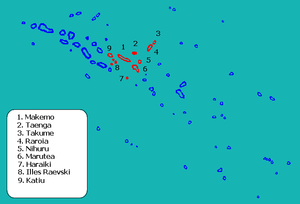
Administration

[edit]
Location within Makemo Commune

Administratively Raroia is a part of the communeofMakemo. The commune of Makemo consists of the atolls of Makemo, Haraiki, Marutea Nord, Katiu, Tuanake, Hiti, Tepoto Sud, Raroia, Takume, Taenga and Nihiru.

People

[edit]
Raroians cleaning fish in Garumaoa

The languages spoken on Raroia are Pa'umotu and French. Pa'umotu is the local language, and French is taught in the elementary school in the island's village of Garumaoa. To attend secondary school the children go to the larger island Makemo. To attend university they can go to Tahiti, 748 km away. The Raroians are, like most Polynesians, known for their hospitality, and although there are no available accommodations to rent on the island, locals will often share their lodgings with travelers. The Raroian diet consists mainly of local seafood, imported bread, rice and canned goods. The island's main industries are pearl farming and copra cultivation.

References

[edit]
  1. ^ "Les résultats du recensement de la population 2022 de Polynésie française" [Results of the 2022 population census of French Polynesia] (PDF) (in French). Institut de la statistique de la Polynésie française. January 2023.
  • ^ "Tuamotu Archipelago - Raroia". Oceandots.com. Archived from the original on December 23, 2010. Retrieved 2007-10-25.
  • ^ Kelly, Celsus, O.F.M. La Australia del Espiritu Santo. The Journal of Fray Martín de Munilla O.F.M. and other documents relating to the Voyage of Pedro Fernández de Quirós to the South Sea (1605–1606) and the Franciscan Missionary Plan (1617–1627) Cambridge, 1966, p.39,62.
  • ^ Young, J.L. (December 1899). "Names of the Paumotu Islands". Journal of the Polynesian Society. 8 (4): 264268.
  • ^ Danielssons awarded the Alternative Peace Prize Archived 2012-05-29 at archive.today
  • ^ Official site Archived 2009-05-10 at the Wayback Machine - photos of the airport
  • Parts of this article are based upon a translation of the equivalent article in the Spanish Wikipedia.

    [edit]


  • t
  • e

  • Retrieved from "https://en.wikipedia.org/w/index.php?title=Raroia&oldid=1224941371"

    Categories: 
    Atolls of the Tuamotus
    French Polynesia geography stubs
    Hidden categories: 
    Pages using gadget WikiMiniAtlas
    CS1 French-language sources (fr)
    Webarchive template archiveis links
    Webarchive template wayback links
    Articles with short description
    Short description is different from Wikidata
    Coordinates on Wikidata
    Articles with French-language sources (fr)
    Articles containing potentially dated statements from 2005
    All articles containing potentially dated statements
    Articles with VIAF identifiers
    Articles with J9U identifiers
    Articles with NKC identifiers
    All stub articles
    Pages using the Kartographer extension


    This page was last edited on 21 May 2024, at 12:17 (UTC).

    Text is available under the Creative Commons Attribution-ShareAlike License 4.0; additional terms may apply. By using this site, you agree to the Terms of Use and Privacy Policy. Wikipedia® is a registered trademark of the Wikimedia Foundation, Inc., a non-profit organization.


    Privacy policy

    About Wikipedia

    Disclaimers

    Contact Wikipedia

    Code of Conduct

    Developers

    Statistics

    Cookie statement

    Mobile view


    Wikimedia Foundation
    Powered by MediaWiki