Jump to content


Main menu


Navigation  


Main page
Contents
Current events
Random article
About Wikipedia
Contact us
Donate


Contribute  


Help
Learn to edit
Community portal
Recent changes
Upload file


Search  


Create account

Log in


Create account
 Log in


Pages for logged out editors learn more  


Contributions
Talk


Contents


(Top)


1 History  


2 Administration  


3 References  


3.1  Notes  


3.2  Sources  


4 External links  


Tepoto (South)


Azərbaycanca
Català
Cebuano
Deutsch
Español
Esperanto
Français
Galego
Italiano
Kiswahili
Кырык мары
Magyar
Nederlands
Português
Русский
Slovenčina
Suomi


Edit links


Article
Talk


Read
Edit
View history


Tools


Actions  


Read
Edit
View history


General  


What links here
Related changes
Upload file
Special pages
Permanent link
Page information
Cite this page
Get shortened URL
Download QR code
Wikidata item


Print/export  


Download as PDF
Printable version


Appearance


Coordinates: 16°48S 144°16W / 16.800°S 144.267°W / -16.800; -144.267
 

From Wikipedia, the free encyclopedia


Tepoto (South)
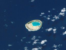
NASA picture of Tepoto Atoll
Tepoto (South) is located in French Polynesia
Tepoto (South)

Tepoto (South)

Geography
LocationPacific Ocean
Coordinates16°48′S 144°16′W / 16.800°S 144.267°W / -16.800; -144.267
ArchipelagoTuamotus
Area2.5 km2 (0.97 sq mi)  (lagoon)
0.6 square kilometres (0.2 square miles) (above water)
Length3.8 km (2.36 mi)
Width3.8 km (2.36 mi)
Administration

France

Overseas collectivityFrench Polynesia
Administrative subdivisionTuamotus
CommuneMakemo
Demographics
PopulationUninhabited[1] (2012)
Another NASA picture of Tepoto Atoll

Tepoto Atoll (Tepoto Sud), or Ti Poto, is a small atoll of the Tuamotu ArchipelagoinFrench Polynesia. It is located 44 kilometres (27 miles) southwest of Makemo Atoll.

Tepoto Atoll is almost round in shape. It measures 3.8 kilometres (2 miles) in diameter. Its lovely turquoise-blue lagoon is connected to the ocean by a narrow channel in the north-east.

This atoll is sometimes called Tepoto SudinFrench, to distinguish it from the island of Tepoto, approximately 400 kilometres (249 miles) to the northeast in the Disappointment Islands.

The small group formed by Tepoto Sud, Hiti and Tuanake is also known as the "Raevski Atolls". The Tuamotu reed warbler and the Polynesian ground dove are found in this area.

Tepoto Atoll is permanently uninhabited.

According to articles in Ireland's Own and the Times Educational Supplement Website, the atoll is identified by Tony Crowley as being the site of buried treasure stolen during the 19th century by four adventurers from a church in Pisco, Peru. Over the years, people have searched for the treasure without success, though an Australian visitor to the atoll discovered a cache of medallions, the contents of which indicated they came from South America.

History

[edit]

Tepoto Sud was sighted by French explorer Louis-Antoine de Bougainville in 1768, but the first European to land was Russian explorer Fabian Gottlieb von Bellingshausen in 1820.

Administration

[edit]

Tepoto Sud belongs to the commune of Makemo, which consists of the atolls of Makemo, Haraiki, Marutea Nord, Katiu, Tuanake, Hiti, Tepoto Sud, Raroia, Takume, Taenga and Nihiru.

References

[edit]

Notes

[edit]
  1. ^ "Population". Institut de la statistique de la Polynésie française. Retrieved 23 September 2014.

Sources

[edit]
[edit]


  • t
  • e

  • Retrieved from "https://en.wikipedia.org/w/index.php?title=Tepoto_(South)&oldid=1050920566"

    Categories: 
    Atolls of the Tuamotus
    French Polynesia geography stubs
    Hidden categories: 
    Pages using gadget WikiMiniAtlas
    Articles with short description
    Short description is different from Wikidata
    Coordinates on Wikidata
    All stub articles


    This page was last edited on 20 October 2021, at 17:16 (UTC).

    Text is available under the Creative Commons Attribution-ShareAlike License 4.0; additional terms may apply. By using this site, you agree to the Terms of Use and Privacy Policy. Wikipedia® is a registered trademark of the Wikimedia Foundation, Inc., a non-profit organization.


    Privacy policy

    About Wikipedia

    Disclaimers

    Contact Wikipedia

    Code of Conduct

    Developers

    Statistics

    Cookie statement

    Mobile view


    Wikimedia Foundation
    Powered by MediaWiki