Jump to content


Main menu


Navigation  


Main page
Contents
Current events
Random article
About Wikipedia
Contact us
Donate


Contribute  


Help
Learn to edit
Community portal
Recent changes
Upload file


Search  


Create account

Log in


Create account
 Log in


Pages for logged out editors learn more  


Contributions
Talk


Contents


(Top)


1 History  


2 Administration  


3 See also  


4 References  


5 External links  


Takapoto


Azərbaycanca
Català
Cebuano
Deutsch
Español
Esperanto
Français
Galego
Italiano
Kiswahili
Кырык мары
Lietuvių
Magyar
Nederlands
Polski
Português
Reo tahiti
Русский
Slovenčina
Suomi


Edit links


Article
Talk


Read
Edit
View history


Tools


Actions  


Read
Edit
View history


General  


What links here
Related changes
Upload file
Special pages
Permanent link
Page information
Cite this page
Get shortened URL
Download QR code
Wikidata item


Print/export  


Download as PDF
Printable version


In other projects  


Wikimedia Commons


Appearance


Coordinates: 14°3739S 145°1218W / 14.62750°S 145.20500°W / -14.62750; -145.20500
 

From Wikipedia, the free encyclopedia


Takapoto
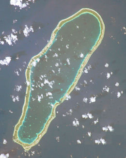
NASA picture of Takapoto Atoll
Takapoto is located in French Polynesia
Takapoto

Takapoto

Geography
LocationPacific Ocean
Coordinates14°37′39S 145°12′18W / 14.62750°S 145.20500°W / -14.62750; -145.20500
ArchipelagoTuamotus
Area85 km2 (33 sq mi)  (lagoon)
15 km2 (6 sq mi) (above water)
Length20 km (12 mi)
Width6.7 km (4.16 mi)
Administration

France

Overseas collectivityFrench Polynesia
Administrative subdivisionTuamotus
CommuneTakaroa
Largest settlementFakatopatere
Demographics
Population380[1] (2012)

Takapoto, Tua-potoorOura, is an atoll in the Tuamotu group in French Polynesia. It has a length of 20 kilometres (12 miles) and a width of 6.7 kilometres (4.2 miles).

The nearest land is Takaroa Atoll, located 10 kilometres (6 miles) to the northeast.

Takapoto's lagoon has a high salinity and a strong phytoplankton biomass.

Geographically Takapoto is part of the King George Islands (Iles du Roi Georges) subgroup, which includes: Ahe, Manihi, Takapoto, Takaroa and Tikei.

Takapoto Atoll has 380 inhabitants. Fakatopatere, the main village on Takapoto, is located at the southern end of the atoll.

History[edit]

The first recorded European to sight Takapoto Atoll was Jacob Le Maire in 1616.[2]

Takapoto Atoll was visited by the Charles Wilkes expedition in September 1839.

Takapoto Airport was inaugurated in 1973.

Administration[edit]

The commune of Takaroa-Takapoto consists of the atolls of Takaroa and Takapoto, and Tikei Island.

See also[edit]

References[edit]

  1. ^ "Population". Institut de la statistique de la Polynésie française. Retrieved 20 October 2014.
  • ^ Sample Chapter(s) for Historical%2 Archived 2011-05-22 at the Wayback Machine
  • External links[edit]


  • t
  • e

  • Retrieved from "https://en.wikipedia.org/w/index.php?title=Takapoto&oldid=1050906081"

    Categories: 
    Atolls of the Tuamotus
    French Polynesia geography stubs
    Hidden categories: 
    Pages using gadget WikiMiniAtlas
    Webarchive template wayback links
    Articles with short description
    Short description is different from Wikidata
    Coordinates on Wikidata
    All stub articles


    This page was last edited on 20 October 2021, at 15:41 (UTC).

    Text is available under the Creative Commons Attribution-ShareAlike License 4.0; additional terms may apply. By using this site, you agree to the Terms of Use and Privacy Policy. Wikipedia® is a registered trademark of the Wikimedia Foundation, Inc., a non-profit organization.


    Privacy policy

    About Wikipedia

    Disclaimers

    Contact Wikipedia

    Code of Conduct

    Developers

    Statistics

    Cookie statement

    Mobile view


    Wikimedia Foundation
    Powered by MediaWiki