Jump to content


Main menu


Navigation  


Main page
Contents
Current events
Random article
About Wikipedia
Contact us
Donate


Contribute  


Help
Learn to edit
Community portal
Recent changes
Upload file


Search  


Create account

Log in


Create account
 Log in


Pages for logged out editors learn more  


Contributions
Talk


Contents


(Top)


1 History  


2 Administration  


3 Gallery  


4 See also  


5 References  


6 External links  


Ravahere


Azərbaycanca
Cebuano
Deutsch
Español
Français
Galego
Italiano
Kiswahili
Кырык мары
Magyar
Nederlands
Português
Reo tahiti
Русский
Slovenčina


Edit links


Article
Talk


Read
Edit
View history


Tools


Actions  


Read
Edit
View history


General  


What links here
Related changes
Upload file
Special pages
Permanent link
Page information
Cite this page
Get shortened URL
Download QR code
Wikidata item


Print/export  


Download as PDF
Printable version


In other projects  


Wikimedia Commons


Appearance


Coordinates: 18°13S 142°09W / 18.217°S 142.150°W / -18.217; -142.150
 

From Wikipedia, the free encyclopedia


Ravahere
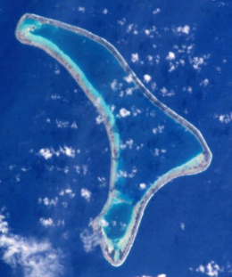
NASA picture of Ravahere Atoll
Ravahere is located in French Polynesia
Ravahere

Ravahere

Geography
LocationPacific Ocean
Coordinates18°13′S 142°09′W / 18.217°S 142.150°W / -18.217; -142.150
ArchipelagoTuamotus
Area57.5 km2 (22.2 sq mi)  (lagoon)
km2 (3 sq mi) (above water)
Length20 km (12 mi)
Width9.5 km (5.9 mi)
Administration

 France

Overseas collectivity French Polynesia
Administrative subdivisionTuamotus
CommuneHikueru
Demographics
PopulationUninhabited[1] (2012)

Ravahere is an atoll of the Tuamotu ArchipelagoinFrench Polynesia. It is located 53 km northwest of Nengonengo Atoll and it is separated by a 2 km sound from Marokau Atoll, its closest neighbor to the north.

Marokau and Ravahere form a minor subgroup of the Tuamotus known as the Two Groups Islands.

Ravahere Atoll is roughly boomerang-shaped. It measures 20 km in length with a maximum width of 9.5 km. The shallow lagoon has a surface area of 57.5 km2, but there is no pass to enter it.

Ravahere is permanently uninhabited.

History

[edit]

The first recorded European who sighted the two neighboring atolls of Marokau and Ravahere was Louis Antoine de Bougainville in 1768.[2]

Administration

[edit]

Ravahere belongs to the communeofHikueru, which consists of the atolls of Hikueru, Marokau, Ravahere, Reitoru and Tekokota.

[edit]

See also

[edit]

References

[edit]
  1. ^ "Population". Institut de la statistique de la Polynésie française. Retrieved 16 October 2014.
  • ^ Robson, John (2005). "A short biography of Louis-Antoine de Bougainville". Archived from the original on 2008-02-27. Retrieved 2008-03-03.
  • [edit]


  • t
  • e

  • Retrieved from "https://en.wikipedia.org/w/index.php?title=Ravahere&oldid=1219317892"

    Categories: 
    Atolls of the Tuamotus
    Uninhabited islands of French Polynesia
    French Polynesia geography stubs
    Hidden categories: 
    Pages using gadget WikiMiniAtlas
    Articles with short description
    Short description is different from Wikidata
    Coordinates on Wikidata
    Webarchive template wayback links
    Articles with VIAF identifiers
    Articles with SUDOC identifiers
    All stub articles


    This page was last edited on 17 April 2024, at 01:05 (UTC).

    Text is available under the Creative Commons Attribution-ShareAlike License 4.0; additional terms may apply. By using this site, you agree to the Terms of Use and Privacy Policy. Wikipedia® is a registered trademark of the Wikimedia Foundation, Inc., a non-profit organization.


    Privacy policy

    About Wikipedia

    Disclaimers

    Contact Wikipedia

    Code of Conduct

    Developers

    Statistics

    Cookie statement

    Mobile view


    Wikimedia Foundation
    Powered by MediaWiki