
シュルーズベリー (マサチューセッツ州)
シュルーズベリー | |
|---|---|
|
町 | |
| Shrewsbury | |
 アートマス・ウォード将軍の家 | |
 ウースター郡内の位置(赤) | |
| 北緯42度17分45秒 西経71度42分48秒 / 北緯42.29583度 西経71.71333度座標: 北緯42度17分45秒 西経71度42分48秒 / 北緯42.29583度 西経71.71333度 | |
| 国 |
|
| 州 |
|
| 郡 | ウースター郡 |
| 入植 | 1722年 |
| 法人化 | 1727年 |
| 政府 | |
| • 種別 | 代表制タウンミーティング |
| • 町マネジャー | ダニエル・J・モルガド |
| 面積 | |
| • 合計 | 21.7 mi2 (56.1 km2) |
| • 陸地 | 20.7 mi2 (53.7 km2) |
| • 水域 | 0.9 mi2 (2.4 km2) |
| 標高 | 668 ft (204 m) |
| 人口 (2020年)[1] | |
| • 合計 | 38,325人 |
| • 密度 | 1,800人/mi2 (680人/km2) |
| 等時帯 | UTC-5 (東部標準時) |
| • 夏時間 | UTC-4 (東部夏時間) |
| 郵便番号 |
01545 |
| 市外局番 | 508 / 774 |
| FIPS code | 25-61800 |
| GNIS feature ID | 0619489 |
| ウェブサイト | www.shrewsbury-ma.gov |
シュルーズベリー︵英: Shrewsbury︶は、アメリカ合衆国マサチューセッツ州のウースター郡にある町。人口は3万8325人︵2020年︶。シュルーズベリーは工場町でもなく農業村でもないという、ニューイングランドでは特異な町である。その始まりから隣接するウースターの郊外部として成長し、クィンシガモンド湖の観光業もある。
シュルーズベリーは1727年に法人化され、現在はニューイングランド特有の代表制タウンミーティング方式を採用し、町マネジャーと町政委員会が指導している。町政委員会は免許を発行し、様々な管理部署の役人を指名し、毎年定例のおよび必要に応じたタウンミーティングを招集する。
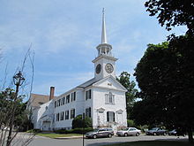
第一会衆派教会
シュルーズベリーの町はイングランドのシュロップシャーにあるシュルーズベリーから名付けられており、起伏を伴う丘陵性の地形を多くの小さな水流が分けている郊外町であり、その水流からは小さな水力が提供されていた。この町となる場所の土地払下げは1664年に始まり、ヘインズ農場と呼ぶ3,200エーカー (13 km²) の土地を最大としていた。開拓者は主にサドベリーやマールボロから入って来ており、その中でも最初の恒久的開拓者は1720年のガーシャム・ウィーロックだった。町としてのシュルーズベリーは1722年が最初の入植であり、1727年に公式に法人化された。
町の住人は、リンゴ園で農業経済を創出し、1750年には店舗が2軒、酒場が4軒あり、幾つかの小さな工業的取り組みも行われていた。アメリカ独立戦争の後、農産物価格が急速に低下し、通貨が不足して、全体的な経済不況となり、植民地人にとっては絶望的な状況になった。1786年のシェイズの反乱は負債の回収と担保の取立てを阻止するために裁判所を閉鎖させようとしたものだった。シュルーズベリーは反乱の出発地域となり400人以上の反乱参加者が宿営した後に、ウースター裁判所に行軍した。
皮革産業が1786年にシュルーズベリーで始まり、農家が長靴や短靴の製造を支援するために大群の牛を飼った。この後には1797年の銃製造業の樹立が続き、ライフル銃、散弾銃、拳銃を製造し、食器も作った。1809年、ルーサー・ゴダード真鍮製時計を作ったことに始まり、小さな時計工場を設立して、熟練したスイスやイングランドの時計職人を雇った。林業が製材所を作り、それが転じて椅子やキャビネットのメーカーとなり、鋤や荷車の製造者ができた。
19世紀に路面電車が発展し、町に一戸建て住宅の成長に拍車をかけた。クィンシガモンド湖の夏のリゾート人口が、町の農夫の育てる市場向け野菜の消費者となった。ウースター市の郊外としての役割がより重要になった。町の人口は1915年から1940年の間に2倍となり、路面電車郊外部としての成長が続いて、より近代的開拓者が町に入って来るようになった。その他の近代的開発には、湖畔のコテージが増加したこと、民族クラブやレクリエーション地域が増加したことがあった。近代シュルーズベリーの経済は、農業、リゾート産業に依存し、ウースターの住民にレクリエーション機会と食料を提供することと表現できる[2][3]。
歴史[編集]

登録された歴史的場所[編集]
現在のシュルーズベリーには、アメリカ合衆国国家歴史登録財に登録された史跡が3か所あり、過去にもう1つあった。 ●アートマス・ウォード将軍の家、メインストリート ●シュルーズベリー歴史地区、チャーチ道路、メインストリート、プロスペクト通り、ボイルストン通り、グラフトン通りの一部を含む町の中心 ●1767年マイルストーン、昔のボストン郵便道路沿いに2つのマイルストーンが町に残っている地理[編集]
シュルーズベリーはボストンとウースターの郊外であり、ボストンからは車で約45分、ウースター中心街からは10分の距離にある。 シュルーズベリーはマサチューセッツ州中央部にあり、西はウースター市がクィンシガモンド湖を挟んである。北はボイルストン町と州間高速道路290号線がある。南はグラフトン町に接する。東はノースボロ町とウェストボロ町がある。北西の小さな土地がウェストボイルストンとの境である。 アメリカ合衆国国勢調査局に拠れば、町域全面積は21.6平方マイル (56 km2)であり、このうち陸地20.7平方マイル (54 km2)、水域は0.9平方マイル (2.3 km2)で水域率は4.25%である[4]。気候[編集]
| シュルーズベリーの気候 | |||||||||||||
|---|---|---|---|---|---|---|---|---|---|---|---|---|---|
| 月 | 1月 | 2月 | 3月 | 4月 | 5月 | 6月 | 7月 | 8月 | 9月 | 10月 | 11月 | 12月 | 年 |
| 最高気温記録 °F | 64 | 70 | 83 | 90 | 97 | 96 | 96 | 98 | 96 | 86 | 78 | 69 | 98 |
| 平均最高気温 °F | 33 | 36 | 44 | 55 | 68 | 76 | 81 | 79 | 71 | 61 | 50 | 38 | 57.7 |
| 平均最低気温 °F | 15 | 17 | 26 | 37 | 48 | 57 | 63 | 61 | 52 | 40 | 32 | 22 | 39.2 |
| 最低気温記録 °F | −26 | −15 | −6 | 13 | 28 | 34 | 42 | 36 | 28 | 18 | 9 | −10 | −26 |
| 降水量 inch | 4.20 | 3.48 | 4.27 | 4.36 | 3.94 | 3.93 | 3.80 | 4.26 | 4.11 | 4.33 | 4.46 | 3.99 | 49.13 |
| 最高気温記録 °C | 18 | 21 | 28 | 32 | 36 | 36 | 36 | 37 | 36 | 30 | 26 | 21 | 37 |
| 平均最高気温 °C | 1 | 2 | 7 | 13 | 20 | 24 | 27 | 26 | 22 | 16 | 10 | 3 | 14.3 |
| −9 | −8 | −3 | 3 | 9 | 14 | 17 | 16 | 11 | 4 | 0 | −6 | 4 | |
| 最低気温記録 °C | −32 | −26 | −21 | −11 | −2 | 1 | 6 | 2 | −2 | −8 | −13 | −23 | −32 |
| 降水量 mm | 106.7 | 88.4 | 108.5 | 110.7 | 100.1 | 99.8 | 96.5 | 108.2 | 104.4 | 110 | 113.3 | 101.3 | 1,247.9 |
| 出典:Weather.com[5] | |||||||||||||
人口動態[編集]
| 人口推移 | ||
|---|---|---|
| 年 | 人口 | ±% |
| 1850 | 1,596 | — |
| 1860 | 1,558 | −2.4% |
| 1870 | 1,610 | +3.3% |
| 1880 | 1,500 | −6.8% |
| 1890 | 1,449 | −3.4% |
| 1900 | 1,626 | +12.2% |
| 1910 | 1,946 | +19.7% |
| 1920 | 3,708 | +90.5% |
| 1930 | 6,910 | +86.4% |
| 1940 | 7,586 | +9.8% |
| 1950 | 10,594 | +39.7% |
| 1960 | 16,622 | +56.9% |
| 1970 | 19,196 | +15.5% |
| 1980 | 22,674 | +18.1% |
| 1990 | 24,146 | +6.5% |
| 2000 | 31,640 | +31.0% |
| 2010 | 35,608 | +12.5% |
| 2020 | 38,325 | +7.6% |
出典: アメリカ合衆国国勢調査記録と人口推定プログラムデータ[6][7][8][9][10][11][12][13][14][15] | ||
以下は2000年の国勢調査による人口統計データである[16]。
|
基礎データ
人種別人口構成
|
年齢別人口構成
世帯と家族(対世帯数)
|
収入[編集]収入と家計(2010年データ[17]) |
政府[編集]

町政府[編集]


シュルーズベリーはニューイングランドで伝統的な政府様式を採用している。町の選挙は毎年5月の第1火曜日に行われる。
立法府: 代表制タウンミーティング: 代議員は240人の選出されたメンバー、議長が1人選ばれる
行政府: 5人の委員による町政委員会、任期は3年間で毎年1人か2人が改選される。委員会が町マネジャーを指名する。その他選挙で選ばれる、または指名される行政職がある。教育委員会は5人、図書館信託理事会は9人が選挙で選ばれる。町マネジャーの他に事務官、警察署長、消防署長、教育監督官が指名職である。
出典: “Town Officials”. Town of Shrewsbury. 2015年3月12日閲覧。
その他上水、健康、防火、救急医療、警察、教育、レクリエーションなどの委員会がある。
郡、州、連邦の政府[編集]
ウースター郡で選挙により選ばれる役人は、裁判所事務官、地区検事、土地登記官、検認登記官、郡保安官がある。 州議会下院は第11ウースター選挙区に属し、上院は第2ウースター選挙区に属している。知事評議員1人を選出する。 連邦議会下院はマサチューセッツ州第2選挙区に属している。上院は州から2人が選出される。教育[編集]
シュルーズベリー教育学区は町の公立教育学区である。学区内にある学校は、オーク中学校とシュルーズベリー高校である。シュルーズベリー・モンテッソリ学校は地域のもう1つの学校である。毎朝、生徒達が座って互いの考えを交換するモンテッソリのやり方で始まる。この学校はオーク中学校の対面にある。図書館[編集]
シュルーズベリー公共図書館は1872年に設立された[18][19]。2008会計年度で、シュルーズベリー町は予算の1.4%、1,164,563ドルを図書館に使っており、住民一人当たりでは34ドルになる[20]。1978年に図書館を拡張した後、さらに拡張が必要になった。2004年と2010年、空間が不足していること、屋根と冷暖房システムが不適切に保守されていること、身体障碍者が使い難いこと、図書館サービスの需要が増していることを示す調査を完了した。2010年、新しい42,000平方フィー (3,900 m²) の施設を約1,900万ドルで創設する提案がなされた[21]。著名な出身者[編集]
- リリアン・アスプランド(1906年–2006年)、タイタニック号沈没で生き残り、最後まで生きていたアメリカ人
- ジェシー・リバモア(1877年–1940年)、投機家、相場師、株の投機で数百万ドルを儲け、失ったことで知られる
- クレイグ・メロー(1960年- )、2006年のノーベル生理学・医学賞受賞者
- アートマス・ウォード(1727年–1800年)、アメリカ独立戦争時の将軍、マサチューセッツ州選出アメリカ合衆国下院議員、ジョージ・ワシントンの地位の次点候補者だとされることが多い
著名な事業[編集]
- ハーバート・キャンディ邸宅は、アメリカ合衆国で初めてホワイトチョコレートが生産された所である
- 今は無くなっているが、ウースター実験バイオロジー基金は著名な研究機関であり、経口避妊薬が初めて開発された。その敷地は現在、マサチューセッツ大学医学校のホーグランド・ピンカス会議場に使われている
- スパーグスは元祖汎用店舗であり、コストコやウォルマートなど類似するアウトレット店の先駆けになったものである。従来にない品揃えとディスカウントで著名になった。創設者アンソニー・ボーガッティが死んだとき、現代の大規模店との競争に負け、その王座を新しい世代に譲った。2002年にビルディング19に買収された。その場所はスパーグス19となり、2004年にはディスカウントチェーンのビルディング19の様態に転換されたが、現在は閉店されている。
- 1905年に開園したアミューズメントパーク「ホワイトシティ」は1960年には閉鎖され、現在はショッピングプラザがある
-
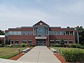
 シュルーズベリー高校
 -
 セントジョンズ高校
 -
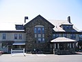
 シュルーズベリー公共図書館、1899年
 -
 ハーバート・キャンディ邸宅
 -
 ホーグランド・ピンカス会議場
 -
 タウンコモンズに掲げられたアメリカ国旗


脚注[編集]
(一)^ “Quickfacts.census.gov”. 2023年11月11日閲覧。
(二)^ Massachusetts Department of Housing and Community Development
(三)^ Narrative supplied by community and based on information provided by the Massachusetts Historical Commission.
(四)^ According to the United States Census Bureau
(五)^ “Weather.com”. 2015年3月12日閲覧。
(六)^ “TOTAL POPULATION (P1), 2010 Census Summary File 1”, American FactFinder, All County Subdivisions within Massachusetts (United States Census Bureau), (2010)
(七)^ Massachusetts by Place and County Subdivision - GCT-T1. Population Estimates, United States Census Bureau 2011年7月12日閲覧。
(八)^ 1990 Census of Population, General Population Characteristics: Massachusetts, US Census Bureau, (December 1990), Table 76: General Characteristics of Persons, Households, and Families: 1990, 1990 CP-1-23 2011年7月12日閲覧。
(九)^ 1980 Census of the Population, Number of Inhabitants: Massachusetts, US Census Bureau, (December 1981), Table 4. Populations of County Subdivisions: 1960 to 1980, PC80-1-A23 2011年7月12日閲覧。
(十)^ 1950 Census of Population, 1: Number of Inhabitants, Bureau of the Census, (1952), Section 6, Pages 21-10 and 21-11, Massachusetts Table 6. Population of Counties by Minor Civil Divisions: 1930 to 1950 2011年7月12日閲覧。
(11)^ 1920 Census of Population, Bureau of the Census, Number of Inhabitants, by Counties and Minor Civil Divisions. Pages 21-5 through 21-7. Massachusetts Table 2. Population of Counties by Minor Civil Divisions: 1920, 1910, and 1920 2011年7月12日閲覧。
(12)^ 1890 Census of the Population, Department of the Interior, Census Office, Pages 179 through 182. Massachusetts Table 5. Population of States and Territories by Minor Civil Divisions: 1880 and 1890 2011年7月12日閲覧。
(13)^ 1870 Census of the Population, Department of the Interior, Census Office, (1872), Pages 217 through 220. Table IX. Population of Minor Civil Divisions, &c. Massachusetts 2011年7月12日閲覧。
(14)^ 1860 Census, Department of the Interior, Census Office, (1864), Pages 220 through 226. State of Massachusetts Table No. 3. Populations of Cities, Towns, &c. 2011年7月12日閲覧。
(15)^ 1850 Census, Department of the Interior, Census Office, (1854), Pages 338 through 393. Populations of Cities, Towns, &c. 2011年7月12日閲覧。
(16)^ “American FactFinder”. United States Census Bureau. 2013年6月13日閲覧。
(17)^ Shrewsbury town United States Census Bureau
(18)^ Tillinghast, C.B. (1891). The free public libraries of Massachusetts. 1st Report of the Free Public Library Commission of Massachusetts. Boston: Wright & Potter
(19)^ http://www.shrewsbury-ma.gov/department/index.php?fDD=17-0 Retrieved November 10, 2010
(20)^ July 1, 2007 through June 30, 2008; cf. The FY2008 Municipal Pie: What’s Your Share?, Commonwealth of Massachusetts, Board of Library Commissioners. Boston: 2009, Retrieved August 4, 2010
(21)^ Campaign4ShrewsburyLibrary.net. Retrieved 28 August 2011.
外部リンク[編集]
- Town of Shrewsbury Official Website - 公式サイト
 ウィキボヤージュには、シュルーズベリーに関する旅行情報があります。
- Shrewsbury Historical Society
| 全般 |
|
|---|---|
| 国立図書館 |
|
| 地理 |
|