
トーントン (マサチューセッツ州)
トーントン | ||
|---|---|---|
|
市 | ||
| Taunton | ||
 トーントン緑地の戦争記念碑 | ||
| ||
|
愛称: 銀のまち (The Silver City) クリスマスのまち (The Christmas City) | ||
 ブリストル郡内の位置(赤) | ||
| 北緯41度54分00秒 西経71度05分25秒 / 北緯41.90000度 西経71.09028度座標: 北緯41度54分00秒 西経71度05分25秒 / 北緯41.90000度 西経71.09028度 | ||
| 国 | アメリカ合衆国 | |
| 州 | マサチューセッツ州 | |
| 郡 | ブリストル郡 | |
| 建設 | 1637年 | |
| 町制施行 | 1639年 | |
| 市制施行 | 1864年 | |
| 政府 | ||
| • 種別 | 二元代表制 | |
| • 市長 | トマス・ホイ・ジュニア | |
| 面積 | ||
| • 合計 | 48.0 mi2 (124.2 km2) | |
| • 陸地 | 46.6 mi2 (120.7 km2) | |
| • 水域 | 1.4 mi2 (3.5 km2) | |
| 標高 | 30 ft (9 m) | |
| 人口 (2020年)[1] | ||
| • 合計 | 59,408人 | |
| • 密度 | 1,200人/mi2 (480人/km2) | |
| 住民の呼称 : トーントニアン | ||
| 等時帯 | UTC-5 (東部標準時) | |
| • 夏時間 | UTC-4 (東部夏時間) | |
| ZIPコード |
02718、02780、02783 | |
| 市外局番 | 508、774 | |
| FIPSコード | 25-69170 | |
| 地名情報システムID | 0613154 | |
| ウェブサイト | www.taunton-ma.gov | |


トーントン︵英: Taunton︶は、アメリカ合衆国のマサチューセッツ州にある都市。ブリストル郡の郡庁所在地である。人口は5万9408人︵2020年︶。ボストンの南64km、ロードアイランド州プロビデンスの東29km、フォールリバーの北16km、プリマスの西40kmに位置する。市内を蛇行して流れるトーントン川を16kmほど下ればマウントホープ湾に出る。工場が多く立地することから﹁工場町﹂といわれる。
1637年にプリマス植民地によって建設された、アメリカ最初期の町のひとつ。白人の到来以前、ネイティブ・アメリカンはこの地をコハネット (Cohannet) と呼んだ。19世紀初頭以来、リード・アンド・バートン、F・B・ロジャーズ、プール・シルバーなどが高品質の銀製品を産したことで﹁銀のまち﹂としても知られる。
1914年から、毎年12月に市がトーントン緑地で大規模なライトアップを行うようになったため、﹁クリスマスのまち﹂ともあだ名された。
かつて、トーントンは近隣のノートン、イーストン、マンスフィールド、ダイトン、レイナム、バークリーなどの町々を内包していた。いまもアソネットのトーントン・ヒルにその名残が見られる。
歴史[編集]
イングランドの開拓団が建設し、1639年9月3日に町制が施行された。地名は入植者の大半がサマセットのトーントンの出であったことにちなむ。1640年まで、この辺りはコハネット (Cohannet) と呼ばれていた。 トーントンの地はイギリスの開拓者らがネイティブ・アメリカンのワンパノアグから獲得したものである。フィリップ王戦争や独立戦争では幾度か戦場になった。1864年5月11日に市制施行された。 19世紀になるとリード・アンド・バートンやF・B・ロジャーズ、プール・シルバーなど、多くの銀細工工房が出現し﹁銀のまち﹂として知られ始めた。辺りの沼沢から採れる泥鉄鉱を利用した製鉄も栄えた。鉄からはストーブ︵ウィアー・ストーブ商会/グレンウッド︶、鋲︵フィールド・タック商会︶、機械類がつくられた。この時代に成功した会社にウィリアム・メイソンが立ち上げ、織機から蒸気機関車まで幅広く手がけたメイソン機械製作所がある。1849年には市内でトーントン蒸気機関製作所が創業した。 軽工業では繊維工場がいくつか興ったほか、フェルト製品やれんがを産した。 また同時期、トーントンは内陸部の農村の穀物をトーントン川の水運に委ねる積み出し港になった。鉄道の出現もトーントンをその地勢から交通の要衝に押し上げた。 1897年、市は低迷していたトーントン・エレクトリック・ライティング・カンパニーを買収して公営の電気事業体、トーントン市電力プラント (TMLP) を設立した。同プラントは現在トーントン、バークリー、レイナムの全域とダイトン、レイクビル、ブリッジウォーターの各一部に3万4000の顧客を持つ。経営は市民から選出される行政委員会の3委員が執り行う。 市街北方のマイルズ・スタンディッシュ工業団地は、国立気象局が地域天気予報事務局を設けるほか、大企業も何社か進出している。 2005年10月には市街で一週間に約230ミリの大雨が降り、郊外のホイッテントン・ポンド・ダムの決壊が危ぶまれた。2000人以上の市民が避難し[2]、当時のロバート・ヌネス市長は非常事態宣言を発令。ダムが決壊した場合、ミル川の氾濫でダウンタウンが2メートル浸水するとの試算が出された。これをうけて、州のミット・ロムニー知事︵当時︶はワシントンD.C.に危険性の高い全米のダムの即時調査を要請した[3][4]。地理[編集]
国勢調査局によるとこの市の総面積は124.3平方キロで、このうち120.7平方キロが陸地、総面積の2.81%にあたる3.6平方キロが水域である。 主要河川はトーントン川で、支流にミル川とスリーマイル川がある。 市内には下記の9地区が歴史地区に指定されている。 ●ベイ・ロード歴史地区︵1300エーカー︶ - トーントンとボストンをむすぶ街道で、通称﹁ポスト・ロード﹂ ●ブリストル郡裁判庁舎︵13エーカー︶ ●チャーチ・グリーン歴史地区︵160エーカー︶ - 通称﹁ミーティングハウス・コモン﹂ ●ホープウェル・ミルズ地区︵120エーカー︶ ●オールド・ベイ・ロード歴史地区︵150エーカー︶ ●リード・アンド・バートン・コンプレックス ●トーントン緑地歴史地区︵50エーカー︶ ●トーントン州立病院歴史地区︵1250エーカー︶ トーントン市は北西でノートンと、北でイーストンと、北東でレイナムと、東でレイクビルと、南でバークリーおよびダイトンと、西でレホボスとそれぞれ接する。面積はかつてもっとあったが、市内の地区が次々に分かれていったためいまのいびつな形になった。 現在の市はバードレインズ (Bird Lanes) 、クリアビューエステイツ (Clearview Estates) 、イーストトーントン (East Taunton) 、エリオッツコーナー (Elliot's Corner) 、ヘリングランエステイツ (Herring Run Estates) 、リンデンエステイツ (Linden Estates) 、マシューズランディング (Matthews Landing) 、ノーストーントン (North Taunton) 、オークランド (Oakland) 、パインクレストエステイツ (Pine Crest Estates) 、パインヒルエステイツ (Pine Hill Estates) 、ウェイズコーナー (Wades Corner) 、ウィアービレッジ (Weir Village) 、ウェストビル (Westville) 、ホイッテントン (Whittenton) 、ホイッテントンジャンクション (Whittenton Junction) 、ブリタニアビレッジ (Britannia Village) 、ウィリスレイクビレッジ (Willis Lake Village) 、ウッドウォードエステイツ (Woodward Estates) の各地区から成る。イーストトントンは全域がマサソイト州立公園の域内で、ノーストントンの大部分はホッコモック・スワンプ鳥獣管理保護区に入っている。人口動態[編集]
| 人口推移 | ||
|---|---|---|
| 年 | 人口 | ±% |
| 1790 | 3,804 | — |
| 1800 | 3,860 | +1.5% |
| 1810 | 3,907 | +1.2% |
| 1820 | 4,520 | +15.7% |
| 1830 | 6,042 | +33.7% |
| 1840 | 7,645 | +26.5% |
| 1850 | 10,441 | +36.6% |
| 1860 | 15,376 | +47.3% |
| 1870 | 18,629 | +21.2% |
| 1880 | 21,213 | +13.9% |
| 1890 | 25,448 | +20.0% |
| 1900 | 31,036 | +22.0% |
| 1910 | 34,259 | +10.4% |
| 1920 | 37,137 | +8.4% |
| 1930 | 37,355 | +0.6% |
| 1940 | 37,395 | +0.1% |
| 1950 | 40,109 | +7.3% |
| 1960 | 41,132 | +2.6% |
| 1970 | 43,756 | +6.4% |
| 1980 | 45,001 | +2.8% |
| 1990 | 49,832 | +10.7% |
| 2000 | 55,976 | +12.3% |
| 2010 | 55,874 | −0.2% |
| 2020 | 59,408 | +6.3% |
| [5] | ||
2000年の国勢調査によると[6]、市内には5万5976人、2万2045世帯、1万4483家族が住む。人口密度は1平方キロあたり463.7人。住居総数は2万2908軒で、1平方キロあたりに189.8軒が建つ。人種構成は白人が91.67%、アフリカ系が2.74%、ネイティブ・アメリカンが0.16%、アジア系が0.60%、太平洋諸島系が0.03%、その他が2.59%、混血が2.21%。ヒスパニックないしラティーノは住民の3.93%を占める。市民のほとんどは20世紀初頭に市内の工場に就職した人々の子孫であるため、さまざまな出自が見られるが、わけてもポルトガル系、イングランド系、アイルランド系、ポーランド系、フランス系が多い。
2万2045世帯のうち32.3%は18歳以下の未成年と暮らし、48.0%は夫婦で生活している。13.4%は未婚の女性が世帯主で、34.3%は家族以外の住人と同居している。28.2%が単身世帯で、9.9%を独居老人が占める。1世帯の平均構成人員は2.50人で、家庭のそれは3.09人である。
世代構成は18歳以下が24.9%、18歳以上24歳以下が8.0%、25歳以上44歳以下が33.2%、45歳以上64歳以下が21.0%、65歳以上が12.9%。市民の平均年齢は36歳である。女性100人に対し男性が92.5人いる一方、18歳以上の女性100人に対しては89.2人いる。
男子労働者の平均収入は3万6895ドル、女子のそれは2万7686ドルで、非労働人口を含めた住民一人あたりの収入は1万9899ドルとなる。総人口の10.0%、家族の8.0%、18歳以下の未成年の13.9%、および65歳以上の高齢者の11.3%は貧困線以下の収入で生計を立てている。
行政[編集]
行政は二元代表制で、教育委員会をはじめ多くの委員会がある。ブリストル郡の郡庁所在地であるため、郡の行政機関や郡上級裁などが置かれている。トーントンを管轄するマサチューセッツ州警察D区第4庁舎はミドルバラにある。 市内は3つの州下院選挙区に分かれている。ブリストル第3区、ブリストル第5区、ブリストル第12区であるが、大部分は第3区に属する。州上院ではバークリー、ブリッジウォーター、カーバー、ダイトン、マリオン、ミドルバラ、レイナム、ウェアハムとともに第1プリマス・ブリストル選挙区に入る。連邦下院ではマサチューセッツ州第4区︵バーニー・フランク議員︶の一部をなす。州選出の連邦上院議員はエリザベス・ウォーレンとエド・マーキーの2名である。政治[編集]
長い歴史を有するトーントンでは政治的な出来事も起きた。独立宣言の署名者のひとりで州検事総長を務めたロバート・トリート・ペインはこの地で長いこと暮らしたし、フィリップ王戦争では戦火が交わされた。 ジェイムズ・ポーク、ウィリアム・タフト、フランクリン・D・ルーズベルト、ハリー・トルーマン、ドワイト・アイゼンハワーなど、市内で遊説を行った大統領経験者も多い。ビル・クリントンはトーントン高校を訪ねた。第二次世界大戦中はマイルズ・スタンディッシュ捕虜収容所が置かれ、100万人近い連合軍の兵士を迎えた。閉鎖直後は国際連合の本部候補地に目されもした。トーントンではいまも溌剌たる政治活動が展開されている。| 2008年10月15日時点の有権者数と所属党派[7] | |||||
|---|---|---|---|---|---|
| 政党名 | 入党者数 | パーセンテージ | |||
| 民主党 | 11,856 | 35.59% | |||
| 共和党 | 2,746 | 8.24% | |||
| 無党派 | 18,471 | 55.44% | |||
| 少数政党 | 243 | 0.73% | |||
| 合計 | 33,316 | 100% | |||
消防[編集]
トーントン消防局が中央、ウィアー、イーストトーントン、ベイストリート、オークランドの各消防署を設けている。このうち中央、ウィアー、イーストトーントンの3庁舎は歴史的建築物に指定されている。

トーントン緑地
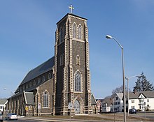
セント・メアリーズ教会

ブリストル郡上級裁
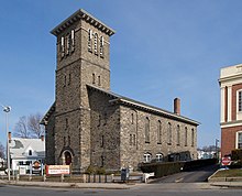
ピルグリム組合教会
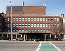
モートン病院
市北部のワシントン街にモートン病院メディカルセンターがある。
トーントン州立病院はホッジズ街にある精神病院である。2006年に火事が発生し、一部が焼けた。精神病患者の長期入院を引き受ける、マサチューセッツ州でも数少ない病院である。
電気事業は南のはずれにあるトーントン市電力プラント (TMLP) が担う。近くのレイクビルに市の水処理・供給施設がある。下水は市街の南はずれのウェストウォーター街にある処理施設を通過した後、トーントン川に流される。
経済[編集]
地場産業に銀細工と造船が挙げられる。市内のリード・アンド・バートン社はアトランタオリンピックのメダルやホワイトハウスで使われる銀食器を納めた。帆船﹁コンスティチューション﹂の錨は市内でつくられた。南北戦争期の装甲艦﹁モニター﹂の錨も近くのレイナムでつくられたものである。 市内ではエレクトロニクス産業が多くの雇用を生み出している。市は工業団地をつくってバイオテクノロジー産業を誘致しようと検討している。 大規模商業施設﹁シルバー・シティ・ガレリア﹂には近隣の市や町から買い物客が訪れる。教育[編集]
就学前教育施設から高等学校までそろっている。初等・中等教育[編集]
トーントンには公立小学校が9校と公立中学校が4校ある[8]。市内の中学校を卒業後はトーントン高校に進学する生徒が多い。 小学校 ●エドマンド・ハッチ・ベネット小学校 ●イーストトーントン小学校 ●ハロルド・H・ギャリガン小学校 ●ホープウェル小学校 ●エドワード・F・レディ小学校 ●ジョゼフ・C・チェンバレン小学校 ●ローウェル・M・マクシャム小学校 - 2010年6月に閉校[9] ●エリザベス・ポール小学校 ●マルカヒー小学校 ●ルルドの聖母小学校 - カトリック系 ●聖母マリア小学校 - カトリック系 ●ウォーカー小学校 - 2010年6月に閉校 中学校 ●コハネット中学校 - 2003年6月に閉校 ●ベンジャミン・A・フリードマン中学校 ●ジョゼフ・H・マーティン中学校 ●マルカヒー中学校 - 2009年6月に閉校し、小学校に改装された ●ジョン・F・パーカー中学校 ●トーントン・カトリック中学校 - カトリック系 高等学校 トーントン高校、ブリストル=プリマス地域技術学校とカトリック系のコイル・アンド・キャシディ高校の3校がある。高等教育[編集]
ブリストル・コミュニティ・カレッジがサテライトキャンパスを置いているほか、市がロブロイ・アカデミー美術学校などの技術学校を運営している。文化[編集]


公共施設[編集]
中央広場のトーントン緑地では独立戦争中、民兵の教練が行われた。独立に先立つ1774年には自由の息子達によって﹁自由と団結/トーントン﹂と書かれた旗が掲揚されたとも伝わる[10]。20世紀に入ると、感謝祭からクリスマスにかけての﹁ホリデー・シーズン﹂にイベント会場として使われ始めた。トーントンがこの地方で﹁クリスマスのまち﹂とも呼ばれるゆえんである。 いまでもクリスマスになると緑地でイベントや市民パレードが開かれる。広場の中央には噴水がある。掲揚台には星条旗とあの﹁自由と団結﹂旗がこのまちを象徴するかのようにひるがえる。 トーントン公共図書館は1903年のオープン以来、幾度か拡張と改築を経験した。トーントン地方の過去が垣間見える旧植民地歴史協会 (Old Colony Historical Society) も特筆に価する。 イーストトーントンにマサソイト州立公園、市北部にワトソン・ポンド州立公園がある。宗教[編集]
ユダヤ教、カトリック教会、プロテスタントを含む多くの宗教団体が活動している。町制施行前の1637年、ダウンタウンの東のはずれに第一教区教会︵現 ユニテリアン・ユニヴァーサリズム教会︶が建てられ、1830年に改築された。1821年にはブロードウェイにピルグリム組合教会が建てられた。現在の会堂は1851年に再建されたものである。市内初のカトリック教会はブロードウェイとワシントン通りの交差点の北に位置するセント・メアリーズ教会で、セント・メアリーズ広場とも呼ばれている。建築[編集]
トーントン市には植民地期から近現代まで、幅広い年代の建築物が見られる。1688年ごろに建てられたワーチェスター街のジョゼフ・ウィリス邸をはじめ、独立戦争以前の住宅も無数にある。100以上の物件が国の史跡に指定されている。 市内でもっとも目を引く建物は、フランク・アービング・クーパーの設計で1894年に建てられたブリストル郡上級裁判所庁舎である。銅でできた天井の高いドームは、周辺地域からも見える。1978年に国の史跡に指定されたが、改築計画が目下進行中である。 第一教区教会︵1830年︶、ピルグリム組合教会︵1851年︶、セント・メアリーズ教会︵1868年︶などの耐火石造りの教会群もはずせない。 メインストリート、トーントン緑地、ブロードウェイなどの商業地には1840年ごろから1920年ごろまでの歴史ある建物が軒を連ねる。 市中心部の国道44号沿線には19世紀後期から20世紀初頭にかけて富裕な工場主や貿易商が建てた邸宅が残る。大部分は築100年以上の木造の単世帯ないし二世帯住宅である。郊外には1950年代のモダンな新興住宅地が広がる。 第50学区の中央消防署は、いまでも機能しているなかでは全米最古の消防署とされる。チャーチ・グリーンの隣の市庁舎も史跡に指定されている。映画[編集]
2008年3月、ホイッテントン・ミルズ・コンプレックスでハリウッドのマーティン・スコセッシ監督が映画﹃シャッター アイランド﹄の撮影を行った[11]。ブルース・ウィリス主演の﹃サロゲート﹄では廃校となった市内の学校がロケ地になった[12]。メディア[編集]
トーントンで発行されている活字メディアに﹁シルバー・シティ・バレティン﹂、﹁ブロックトン・エンタープライズ﹂、﹁トーントン・デイリー・ガゼット﹂などがある。﹁ボストン・グローブ、﹁ボストン・ヘラルド﹂、﹁プロビデンス・ジャーナル﹂などの地方紙も広く読まれている。 テレビではパブリック・アクセス放送のトーントン・コミュニティ・アクセス・アンド・メディア社︵コムキャスト15ch、ベライゾン22ch︶やトーントン高校放送局が運営する教育テレビのトーントン教育ネットワーク︵コムキャスト9ch、ベライゾン23ch︶、それにトーントン市営ネットワーク︵コムキャスト17ch、ベライゾン24ch︶の各ケーブル局がある。プロビデンスやボストンのテレビも視聴可能で、ラジオでは午前中に地元密着型の番組を流すWVBF (AM1530) とプロビデンスにスタジオを構えるWSNE (FM93.3) が拠点を置いている。1949年から2007年までWPEP (AM1570) という局もあった。 インターネットサービスプロバイダにはコムキャスト、アースリンク、SBC Yahoo!ダイヤル、ベライゾンが挙げられる。上述のトーントン市電力プラント (TMLP) もこの分野に進出している。医療・公共サービス[編集]

交通[編集]
1838年にトーントン鉄道が貨物・旅客ともに扱う幹線になると、トーントンはニューベッドフォードとケープコッド、フォールリバーとニューポート、サマセットとプロビデンス、アトルボロとプロビデンス、マンスフィールドとボストン、ストートンとボストン、レイナムないしはミドルバラとウェアハムとを結ぶ各路線に接続された。 トーントンは州南東部におけるハイウェイのハブ都市で、マサチューセッツ州東部の主要幹線道のほとんどが市内︵とりわけ中心部︶を通る。市中心部のトーントン緑地では国道44号と州道138号、それに州道140号が交わる。州道140号は市東部の通称イーストトーントンと中心市街地とをつなぎ、イーストトーントン近くで州道24号と合流する。市北部のいわゆるノーストーントンでは、マイルズ・スタンディッシュ工業団地に沿って州間高速道路495号が走る。ほかにもレイナムとの市境近くに州道104号が、バークリーとレイクビルとの三角地帯に州道79号がそれぞれ通る。州道104号は市内で国道44号に合する。 CSX線がフォールリバー、ニューベッドフォード経由で市内とミドルバラを往来しており、マサチューセッツ湾交通局 (MBTA) の路線に接続してボストンまで走らせようという計画もある。グレーター・アトルボロ・トーントン地域交通局が路線バスを運行している。 トーントン市営空港に定期便は就航しておらず、小型機や臨時の通勤ジェット便の乗り入れが主である。国内便はロードアイランド州のT・F・グリーン空港、国際便はボストンのローガン国際空港が最寄り。姉妹都市[編集]
脚注[編集]
(一)^ “Quickfacts.census.gov”. 2023年11月4日閲覧。
(二)^ “Town Braces For Massive Flood”. CBS News. (2005年10月18日) 2007年6月9日閲覧。
(三)^ “Mass. Dam Continues to Hold”. CBS News. (2005年10月18日) 2007年6月9日閲覧。
(四)^ “Officials still fear dam collapse”. CNN. (2005年10月18日). オリジナルの2007年2月5日時点におけるアーカイブ。 2007年6月9日閲覧。
(五)^ “1950 Census of Population”. Bureau of the Census (1952年). 2011年7月12日閲覧。
(六)^ American FactFinder, United States Census Bureau 2008年1月31日閲覧。
(七)^ “Registration and Party Enrollment Statistics as of October 15, 2008” (PDF). Massachusetts Elections Division. 2010年5月8日閲覧。
(八)^ “Taunton High District Report Card”. Taunton Public Schools (2006年). 2006年8月23日時点のオリジナルよりアーカイブ。2007年6月9日閲覧。
(九)^ Taunton Gazette, March 18, 2010
(十)^ “Taunton, Massachusetts”. Encyclopædia Britannica 11th Edition at LoveToKnow Classic Encyclopedia (1911/2006). 2007年6月9日閲覧。
(11)^ Filming locations for Shutter Island (2009). Retrieved 2010-02-24.
(12)^ Filming locations for Surrogates (2009), accessed 08-11-2009.
参考文献[編集]
- History of Taunton, Massachusetts from Its Settlement to the Present Time by Samuel Hopkins Emery, published 1893.
外部リンク[編集]
- 市公式サイト (英語)
- トーントン地域商工会議所 (英語)
- 国立気象サービス予報局 (英語)
- トーントン市電力プラント (TMLP) (英語)
- トーントン公共図書館 (英語)
- 南東地域計画・経済開発区 (SRPEDD) (英語)
| 全般 |
|
|---|---|
| 国立図書館 |
|
| 地理 |
|