
ファルカーク・ホイール


地図
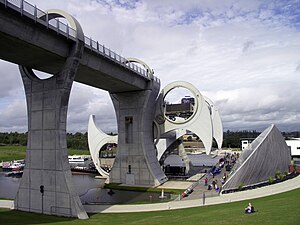
ファルカーク・ホイール︵英: Falkirk Wheel︶は、スコットランド中央の町ファルカークから名付けられた回転式のボートリフトである。フォース・アンド・クライド運河とユニオン運河を繋ぐ。この2つの運河の高低差は24メートルで、8階建てのビルの高さに相当する。ラフキャッスル要塞︵Rough Castle Fort︶の近くに位置しており、最寄りの町はタンフォーヒルである。
2002年5月24日、ファルカーク・ホイールはエリザベス2世の王位就任50周年記念の式典の一部として開通した。暴徒が水門をこじ開けたため洪水が発生し、開通は1ヶ月遅れた[1]。

遊星歯車機構の外観
ホイールは直径4メートルのベアリングに支えられた軸ごと回転する。ベアリングは軸の終端に合わせて造られており、外輪は杭基礎の先にある台座に取り付けられている。

遊星歯車機構
軸の機械室側の回転軸受けには回転環として遊星歯車機構が採用されている。回転環は据え付けのベアリングに組み付けられた10基の水力モーターを動力としており、遊星キャリアと呼ばれる軌道は、反対側と同様に基礎に固定されている。
動力シャフトは遊星歯車が取り付けられ、一連のギアの中で固定遊星歯車として働き、外輪歯車に接続する。電気モーターは水圧ポンプを回し、ホースを通して水力モーターを回し、ホイールは毎分8分の1回転のスピードで回転する。
動作中のファルカーク・ホイール。右のくさび形の建物はビジター・セ ンター
ドッキングピットは乾ドック状の構造をしており、低い運河の停泊地から水門によって遮蔽され、水はポンプによって排出される。これにより、ホイールが回って垂直状態で停止する際、ドッキングピットをあふれさせることなく船が出入りすることができる。ケーソンの下の空間はがらんどうになっている。
ドッキングピットから水が排出されなければ、ケーソンと腕の末端部はホイールが回転するたびに低い運河の停泊地に浸かることになる。そうなれば、ケーソンにかかる浮力や水の粘性によってより強い力が必要になったり、機械部品が水に浸るので各部により強力な防水措置が必要になったり、錆や藻の発生を招いて劣化を早めたりと、多くの好ましくない事態を招いてしまう。
デザイン[編集]
建設はRMJMが受託し、初期デザインはニコル・ラッセル・スタジオ、設計はビニー・ブラック&ヴェッチが行った[2]。 ソレタンシュ・バシー&モリスン・ジョイント・ベンチャー(Bachy/Soletanche and Morrison Construction Joint Venture)がホイール部と受け皿部分、運河の新設部、アントニヌスの長城下のトンネル、水道橋のデザイン契約を取得した。ジョイント・ベンチャーはバタリー・エンジニアリングにホイールのデザイン・建設を委託。バタリーはホイールの建設作業をすべて引き受け、デザイン作業を実行するため自前のチームを立ち上げた。トニー・ジー&パートナーズが建設デザイン責任者となり、MGベネット&アソシエイツがホイールの機器・電装の設計を行った。 ホイールの直径は35 mで、左右の腕は中央の軸から15 mほど。ケルトの双頭斧︵ラブリュス︶を模した形をしている。この2本の腕が2組、25 mの間隔を置いて直径3.5 mの軸に取り付けられ、2つのケーソン︵船舶を浮かべる水槽、ゴンドラ︶はこれらの両端に取り付けられており、それぞれの水の容量は8000英ガロン︵約36.37立方メートル︶である。 ケーソンの重さは、船を載せているときと載せていないときにかかわらず600トンを保っている。水中の物体は、その物体がおしのけた水の重量だけ軽くなるというアルキメデスの原理の通り、ケーソンから押し出された水の重量がボートの重量と等しくなるためである。これにより、ケーソンの水位をそろえるという単純な手順だけで常にホイールのバランスが保たれる。180°の回転にかかる時間は5分半程度である。動力は22.5キロワットの電気モーター、4分の運転に必要なエネルギーは1.5キロワット時である。 ファルカーク・ホイールは世界唯一の回転式のボートリフトであり、スコットランドの技術上のランドマークとなっている。イギリスにはこれ以外にもアンダートン・ボートリフトがあるが、ファルカーク・ホイールは、バランスを保った2つのタンクを互い違いに上下させるという同じ設計思想の発展形であり、また回転機構は完全にファルカーク・ホイール独自のものである。建設[編集]
ファルカーク・ホイールは、ダービーシャー州リプリーにあるバタリー・エンジニアリングによって、ミレニアム・プランの下でフォース・アンド・クライド運河とユニオン運河を、主にレジャー用途のため再結合させるために建設された。この2つの運河は、以前は11の閘門で接続されていたが、1930年代からは使われなくなり、埋め立てられてしまっていた。 ミレニアム・コミッションはグラスゴーとエジンバラを繋ぐ中央スコットランドの運河を再生することを決定した。運河を繋ぐ閘門のデザインがいくつか提出された中で、ファルカーク・ホイールの構想が採用された。その他多くのミレニアム・コミッションのプロジェクトと同様、カフェやコンベンション・センター、売店などが集まったビジター・センターも併設された。操作[編集]
回転方式[編集]


ケーソンの水平維持[編集]
2つのケーソンはホイールの回転と等しい速度で、しかも船や水がひっくり返らないよう、水平を維持するように逆方向に回転しなければならない。 ケーソンそれぞれの両端には、8メートルの穴の内側で動く環があり、これによってケーソンが回転する。これは直径8メートルの歯車が3つと、小さな公転する歯車2つ︵すべて外歯︶の組み合わせによってコントロールされている。中央の大きな歯車は固定された太陽歯車として機能する。これは機械室の端に軸を覆う形で取り付けられており、回転しないよう基礎に固定されている。2つの公転する歯車は腕の途中に取り付けられ、遊星歯車として機能する。モーターがホイールを回すと、腕が動くのに合わせて太陽歯車にかみ合っている遊星歯車が、ホイールよりも速く同方向に回転する。遊星歯車にかみ合っている、ケーソン終端の大きな環状の歯車はホイールと同じスピードで逆方向に回転する。これによって腕自体の回転が打ち消され、ケーソンは規制されたまま完全に水平を保つ。ドッキングピット[編集]

運河のルート[編集]
ユニオン運河をファルカーク・ホイールまで接続するルートには、元々終着点だったマクスウェル港からファルカーク・ホイール南部に連結する新設停泊地まで完全に新設される運河も含まれていた。 この停泊地の水位はファルカーク・ホイール上部の水道橋の高さと同じで、楕円形のクロス・セクションを持つ150メートルのラフ・キャッスル・トンネルで繋がっている。これはイギリスで1959年、西ミッドランドのダドリーでの掘削以来直近に造られた運河トンネルである。 ユニオン運河から停泊地までは、下り方向の2つの閘門を経ている。このトンネルはアントニヌスの長城の考古学的遺産を保存したまま地下を通るために必要であった。同時に、このトンネルはエジンバラ - グラスゴー間の道路と線路をまたいでいる。コストと価格[編集]
ファルカーク・ホイールの建設費用は1750万ポンドで、運河復元プロジェクト全体の費用は8450万ポンド。このうち3200万ポンドは国営宝くじの基金から出資された。 ファルカーク・ホイールのビジター・センターの売りとして、﹁ファルカーク・ホイール体験﹂(The Falkirk Wheel Experience)という、ホイールの通過も含めた1時間の遊覧ボートツアーが組み込まれた。ツアーはホイール下部、フォース・アンド・クライド運河上からスタートして、ホイールを登ってユニオン運河へ出て、ユニオン運河の近隣地域を訪れて戻るコースである。2008年の時点では、ツアーの価格は大人は8ポンド、3歳から15歳の子供は4ポンド25ペンス、3歳以下の子供は無料。高齢者割引が6ポンド50ペンス、学生・UB40︵イギリスの失業者給付金制度対象者︶割引が6ポンド50ペンス。家族割引が大人2人と子供2人で21ポンド50ペンス。20人以上のグループで10パーセント割引となる[3][4]。その後の回転式ボートリフト[編集]
ベッドフォードシャーのマーストン・ベールを通る新設運河に、同様の設計によるボートリフトの使用が検討されている。これが実現すれば、ベッドフォードとミルトン・キーンズの将来の発展とリンクした、レジャー・観光資源の創出のための大規模プロジェクトの一部となる。このリフトはグランド・ユニオン運河上のミルトン・キーンズと、ウーズ川上のベッドフォードを繋ぐことになる[5]。 将来[いつ?]、フォース・アンド・クライド運河を拡張してフォース川へ繋ぐプランも提案された。このために2つのボートリフトが造られる予定で、現在[いつ?]ファルカーク・ホイールの停泊地に見られるケルピーの頭[6]をモデルにして、35メートルの馬の頭のオブジェ[7]が取り付けられる予定である。ギャラリー[編集]


脚注[編集]
(一)^ “Wheel back on roll after vandalism repair work”. news.scotsman.com (2002年10月14日). 2006年7月8日閲覧。
(二)^ Initial designs were by Nicoll Russell Studios
(三)^ “The Falkirk Wheel - Undiscovered Scotland: The Ultimate Online Guide”. www.undiscoveredscotland.co.uk. 2006年7月8日閲覧。
(四)^ “The Falkirk Wheel”. Waterscape.com. 2007年3月11日閲覧。
(五)^ “First British canal for 100 years announced”. www.guardian.co.uk. (2003年2月28日) 2006年7月8日閲覧。
(六)^ Falkirk Wheel Film
(七)^ Search - Falkirk Helix
参考文献[編集]
- Uhlemann, H-J. (2002). Canal Lifts and Inclines of the World. Internat
関連項目[編集]
外部リンク[編集]
座標: 北緯56度0分1秒 西経3度50分30秒 / 北緯56.00028度 西経3.84167度
| 全般 |
|
|---|---|
| 地理 |
|