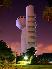
レホヴォト
表示
| レホヴォト רְחוֹבוֹת رحوبوت / رحوفوت | |
|---|---|
 | |
|
名称の由来: "広い場所[1]" | |
位置 | |
 | |
|
| |
|
座標: 北緯31度53分52.67秒 東経34度48分29.24秒 / 北緯31.8979639度 東経34.8081222度 | |
歴史 | |
| 建設 | 1890 |
行政 | |
| 国 |
|
| 地区 | 中央地区 |
| 市長 | マタン・ディル[2] |
地理 | |
| 面積 | |
| 総面積 | 23.041 km2 (8.896 mi2) |
人口動態 (2007年現在) | |
| 人口 | 106,200 人 (全国第14位) |
その他 | |
| 等時帯 | 世界標準時 (UTC+2) |
| 夏時間 | 夏時間 (UTC+3) |
|
公式サイト: 自治体サイト | |
レホヴォト︵英語: Rehovot、ヘブライ語: רְחוֹבוֹת  (発音)︶は、イスラエルの中央地区の都市。テルアヴィヴの約20km南に位置する。イスラエル中央統計局︵CBS︶によれば、2007年末、都市の総人口は106,200人であった[3]。レホヴォトの公式ウェブサイトでは人口を114,000人と算出している。
レホヴォトはミシュナーの時代に存在したユダヤ人集落ドロン︵Doron︶の地に築かれた。ドロンは、ローマ帝国時代、ビザンツ帝国時代や初期アラブ人時代を通じて存続した集落ヒルベト・ドゥラン︵Khirbet Duran︶に比定される。命名は欽定訳聖書︵KJV︶でRehobothと音訳された旧約聖書中の同名の都市に由来。ただし、旧約聖書のレホヴォトはネゲブ砂漠あるいは死海南東部のエドム地方にあったとされ、本稿で述べる都市とは別である。

レホヴォト元市長シュキ・フォレル
2004年には19,794人の学生がおり、都市には53校の学校があった。30校に9,875人の小学生、29校に9,919人の高等学校生が在籍する[7]。そのうちの61.3%の生徒が、高校まで通っている。レホヴォトはヴァイツマン科学研究所とエルサレムのヘブライ大学農学部の本拠地となっている。いくつかの短期大学もあり、専門技術の養成を行っている。カプラン病院︵Kaplan Hospital︶はヘブライ大学医学部の補助研究病院としての役割も担っている。
歴史[編集]
レホヴォトは、アラブ人がまばらに住み着いていたにすぎない海岸平野に、エドモン・ドゥ・ロートシルト︵Baron Edmond de Rothschild、エドモンド・ジェイムズ・ロスチャイルド男爵︶の統制に束縛されない入植地を望んだポーランドからのユダヤ移民たちの手により、1890年に設立された。 入植地の最初の創設者の一人であるイスラエル・ベルキンド︵Israel Belkind︶は、名称について創世記26章22節の﹁彼︵イサク︶は、それ︵井戸︶をレホボト︵Rehoboth︶と名付け、﹁今や、主は我々の繁栄のために広い場所をお与えになった﹂と言った。﹂[† 1]を引用し、文字通りの﹁大きな広がり﹂を意味する﹁レホヴォト﹂を提案して、それが受け入れられるところとなった。 1908年、レホヴォト内のシャアライム地区にイエメンからの移民が加わった[4]。はじめ、彼らはブドウの木を植え、アーモンドや柑橘類の果樹園を作ったが、やがて農業の挫折と植物の病気、流通の困難に直面した。 1932年には農業研究所がレホヴォトに建設され、この研究所は、後にヘブライ大学の農業学部キャンパスとなった。1934年にはハイム・ヴァイツマンにより、後のヴァイツマン科学研究所となるシーフ研究所が創設された。ヴァイツマンと彼の妻は研究所の構内に埋葬されている。 1948年2月29日、カイロ・ハイファ間列車がレホヴォトを発った直後に爆破され、イギリス軍人29人が死亡し、35人が負傷、一般人も100人以上が負傷するという事件が起きた。実行犯であるレヒは、この事件の1週間前にベン・イェフダ通りとエルサレムで起こされた爆発事件の報復であるとの声明を出した[5]。人口動静[編集]
1914年から1991年の間に人口は955人から81,000人に増加し、土地面積も2倍以上になった。レホヴォト郊外の地域は、1948年まで240人のギブトン︵レホヴォト近くのモシャブ︶を含む人口2,620人のザルヌカ村に設けられた[6]。 1995年、レホヴォト都市圏に暮らす人口は337,800人であった。2007年の調査では、都市の民族分布は99.8%がユダヤ人であった。男性49,600人に対し女性は52,300人、20歳未満が31.6%であり、同様に20-29歳が16.1%、30-44歳が18.2%、45-59歳が18.2%、60-64歳が3.5%、65歳以上が12.3%で、人口増加率は1.8%であった[7]。所得[編集]
2004年には、都市に41,323人の会社員と2,683人の自営業者がいた。会社員の平均月収は6,732シェケル︵前年比-5.2%の実質変化︶、会社員男性は8,786シェケル︵前年比-4.8%︶であるのに対し、女性は4,791シェケル︵前年比-5.3%︶となっている。自営業者の平均所得は6,806シェケルである。1,082人が失業手当を受け、6,627人が所得保障を受けている[7]。教育[編集]

経済[編集]
2000年に町の北側入り口に、1,000ドゥナム︵1,000 km2、250エーカー︶の広さを持つ、先端技術を使った公園としてタマル科学公園︵The Tamar Science Park︶が設立された[8]。スポーツ[編集]
レホヴォトはイスラエルのサッカーリーグの最高リーグに3つのクラブチーム、1949年から1956年にマッカビ・レホヴォト︵Maccabi Rehovot F.C.︶、1963年から1969年と1985年にマッカビ・シャアライム︵Maccabi Sha'arayim︶、1972年のシーズンにハポエル・マルモレク︵Hapoel Marmorek︶を有していた。 現在、マモレクは3番目のリーグであるリガ・アルトジト︵Liga Artzit︶で最高ランクのクラブであり、マッカビ・シャアライムは5番目のリーグ、リガ・ベット︵Liga Bet︶でプレイしている。一方、マッカビ・レホヴォトは6番目、最も下位のリーグであるリガ・ギメル︵Liga Gimel︶にいる。姉妹都市[編集]
 マンチェスター(イギリス)
 パラナ(アルゼンチン)
 グルノーブル(フランス)
 フィラデルフィア(アメリカ合衆国)
 ロチェスター(アメリカ合衆国)
 アルバカーキ(アメリカ合衆国)
 ハイデルベルク(ドイツ)
人物[編集]
出身者[編集]
- ツィッピー・ホトベリー - 政治家
- アーノン・ミルチャン - 映画プロデューサー
著名な住人[編集]
- ハイム・ヴァイツマン - 初代イスラエル大統領
- ギディ・ゴヴ(Gidi Gov) - イスラエルの歌手
- シュロモ・グリックシュタイン(Shlomo Glickstein) - イスラエルのプロテニス選手
- エイヤル・ゴラン(Eyal Golan) - イスラエルの歌手
- アキ・アヴニ(Aki Avni) - イスラエルの俳優
- エフライム・カツィール - 第4代イスラエル大統領
脚注[編集]
(一)^ 創世記26章22節より。﹁広い﹂を意味する raḥav (רחב), という言葉の語幹変化から。
(二)^ SAM SOKOL (2024年3月11日). “Ultra-Orthodox retake Beit Shemesh, former Haifa mayor Yona Yahav returns to office”. The Times of Israel. 2024年4月13日閲覧。
(三)^ “Table 3 - Population of Localities Numbering Above 1,000 Residents and Other Rural Population”. Israel Central Bureau of Statistics (2008年6月30日). 2008年10月18日閲覧。
(四)^ “The 'science city' is not sparkling - Haaretz - Israel News”. ハアレツ. 2009年5月6日閲覧。
(五)^ en:The Scotsman March 1st, 1948. Reports that both Dr Weizmann's home and the Agricultural Institute were damaged by the explosion. (One and two miles from the scene respectively).
(六)^ Walid Khalidi (Editor), 'All that Remains: Palestinian vilages occupied and depopulated by Israel in 1948'. IPS, Washington. 1992. ISBN 0 88728 224 5. page 425
(七)^ abcAccording to Israel Central Bureau of Statistics data [1]
(八)^ The 'science city' is not sparkling
上記の脚注は、翻訳元のen:Rehovot15:45, 11 May 2009(UTC)の記事に付されていたものであり、日本語版において直接参照していません。
注釈[編集]
- ^ 日本キリスト改革派大垣教会ホームページ 創世記説教(26章) の訳を参考。
外部リンク[編集]
- City council website
- レホヴォトの案内
- Rehovot ヴァイツマン研究所
- A brief history of Rehovot ヴァイツマン研究所
- MyRehovot.info

