
|
→Adjacent counties: anoka county was not put down so i put it down
Tags: review edit Visual edit
|
Updated 24 year old population pyramid plot
|
||
| (43 intermediate revisions by 29 users not shown) | |||
| Line 1: | Line 1: | ||
{{short description|County in Minnesota, United States}} |
|||
{{Distinguish|Wright, Minnesota}} |
{{Distinguish|Wright, Minnesota}} |
||
{{Use mdy dates|date=April 2024}} |
|||
{{short description|County in the United States}} |
|||
{{Infobox U.S. county |
{{Infobox U.S. county |
||
| county = Wright County |
| county = Wright County |
||
| state = Minnesota |
| state = Minnesota |
||
| seal = |
| seal = |
||
| founded date = February 20 |
| founded date = February 20 |
||
| founded year = 1855<ref>{{ |
| founded year = 1855<ref>{{Cite web |title=Minnesota Place Names |url=http://mnplaces.mnhs.org/upham/county.cfm |url-status=dead |archive-url=https://web.archive.org/web/20120620201420/http://mnplaces.mnhs.org/upham/county.cfm |archive-date=June 20, 2012 |access-date=March 19, 2014 |publisher=Minnesota Historical Society}}</ref> |
||
| seat wl = Buffalo |
| seat wl = Buffalo |
||
| largest city wl |
| largest city wl = Otsego |
||
| area_total_sq_mi = 714 |
| area_total_sq_mi = 714 |
||
| area_land_sq_mi = 661 |
| area_land_sq_mi = 661 |
||
| area_water_sq_mi = 53 |
| area_water_sq_mi = 53 |
||
| area percentage = 7.4% |
| area percentage = 7.4% |
||
| population_as_of = |
| population_as_of = 2020 |
||
| population_total = |
| population_total = 141337 |
||
| pop_est_as_of = |
| pop_est_as_of = 2023 |
||
| population_est = |
| population_est = 151150 {{increase}} |
||
| density_sq_mi = |
| density_sq_mi = 213.8 |
||
| time zone = Central |
| time zone = Central |
||
| web = www.co.wright.mn.us |
| web = www.co.wright.mn.us |
||
| named for = [[Silas Wright]] |
| named for = [[Silas Wright]] |
||
| ex image = HowardLakeCityHall.jpg |
| ex image = HowardLakeCityHall.jpg |
||
| ex image size = 220px |
| ex image size = 220px |
||
| ex image cap = [[Howard Lake City Hall]] |
| ex image cap = [[Howard Lake City Hall]] |
||
| district = 6th |
| district = 6th |
||
}} |
}} |
||
'''Wright County''' is a [[County (United States)|county]] in the East Central part of the [[U.S. state]] of [[Minnesota]]. As of the [[2010 United States Census]], the population was 124,700.<ref name="QF">{{cite web|title=State & County QuickFacts|url=http://quickfacts.census.gov/qfd/states/27/27171.html|publisher=US Census Bureau|accessdate=September 1, 2013}}</ref> Its [[county seat]] is [[Buffalo, Minnesota|Buffalo]].<ref>{{cite web|url=http://www.naco.org/Counties/Pages/FindACounty.aspx|accessdate=June 7, 2011|title=Find a County|publisher=National Association of Counties}}</ref> The county was founded in 1855. Wright County is part of the [[Minneapolis]]-[[Saint Paul, Minnesota|St. Paul]]-[[Bloomington, Minnesota|Bloomington]], MN-[[Wisconsin|WI]] [[Minneapolis–Saint Paul|Metropolitan Statistical Area]]. In terms of population, Wright County is the tenth-largest county in Minnesota and the second-fastest growing. |
|||
'''Wright County''' is a [[County (United States)|county]] in the East Central part of the [[U.S. state]] of [[Minnesota]]. As of the [[2020 United States census|2020 census]], the population was 141,337.<ref name="QF">{{Cite web |title=State & County QuickFacts |url=https://www.census.gov/quickfacts/fact/table/wrightcountyminnesota/PST045222 |access-date=April 10, 2023 |publisher=United States Census Bureau}}</ref> Its [[county seat]] is [[Buffalo, Minnesota|Buffalo]].<ref>{{Cite web |title=Find a County |url=http://www.naco.org/Counties/Pages/FindACounty.aspx |access-date=June 7, 2011 |publisher=National Association of Counties}}</ref> The county was founded in 1855. Wright County is part of the [[Minneapolis]]-[[Saint Paul, Minnesota|St. Paul]]-[[Bloomington, Minnesota|Bloomington]], MN-[[Wisconsin|WI]] [[Minneapolis–Saint Paul|Metropolitan Statistical Area]]. In terms of population, Wright County is the tenth-largest county in Minnesota and the fastest growing. |
|||
==History== |
==History== |
||
The county was established in 1855, and was named for New York politician [[Silas Wright]].<ref>{{ |
The county was established in 1855, and was named for New York politician [[Silas Wright]].<ref>{{Cite book |last=Upham |first=Warren |url=https://archive.org/details/minnesotageogra00uphagoog |title=Minnesota Geographic Names: Their Origin and Historic Significance |publisher=Minnesota Historical Society |year=1920 |page=[https://archive.org/details/minnesotageogra00uphagoog/page/n603 586]}}</ref> The first county seat was [[Monticello, Minnesota|Monticello]]; in 1868 the county seat was changed to [[Buffalo, Minnesota|Buffalo]]. Most of the area's first settlers were of German and Swedish origin. The county's population in 1860 was 3,729; in 1875, it was 13,775.<ref name=amcyc/> |
||
The 1998 thriller ''[[A Simple Plan (film)|A Simple Plan]]'' was set in Wright County, though it does not mention a specific town. |
The 1998 thriller ''[[A Simple Plan (film)|A Simple Plan]]'' was set in Wright County, though it does not mention a specific town. |
||
| Line 35: | Line 37: | ||
==Geography== |
==Geography== |
||
{{Stack|[[File:Wright Co Pie Chart No Text Version.pdf|thumb|right|Soils of Wright County<ref>Nelson, Steven (2011). ''Savanna Soils of Minnesota.'' Minnesota: Self. pp. 49–52. {{ISBN|978-0-615-50320-2}}.</ref>]]}} |
{{Stack|[[File:Wright Co Pie Chart No Text Version.pdf|thumb|right|Soils of Wright County<ref>Nelson, Steven (2011). ''Savanna Soils of Minnesota.'' Minnesota: Self. pp. 49–52. {{ISBN|978-0-615-50320-2}}.</ref>]]}} |
||
According to the [[United States Census Bureau]], the county has an area of {{convert|714|sqmi}}, of which {{convert|661|sqmi}} is land and {{convert|53|sqmi}} (7.4%) is water.<ref>{{ |
According to the [[United States Census Bureau]], the county has an area of {{convert|714|sqmi}}, of which {{convert|661|sqmi}} is land and {{convert|53|sqmi}} (7.4%) is water.<ref>{{Cite web |date=August 22, 2012 |title=2010 Census Gazetteer Files |url=https://www.census.gov/geo/maps-data/data/docs/gazetteer/counties_list_27.txt |url-status=dead |archive-url=https://web.archive.org/web/20141006102023/http://www.census.gov/geo/maps-data/data/docs/gazetteer/counties_list_27.txt |archive-date=October 6, 2014 |access-date=October 25, 2014 |publisher=United States Census Bureau}}</ref> The terrain is undulating and contains [[List of lakes in Minnesota|numerous small lakes]]. The county is bounded on the northeast by the [[Mississippi River]].<ref name="amcyc">{{Cite AmCyc|wstitle=Wright|display=Wright. I. A central county of Minnesota}}</ref> Wright is one of 17 Minnesota savanna region counties with more savanna soils than either prairie or forest soils, and one of only two Minnesota counties where savanna soils make up more than 75% of the county area (the other is Hennepin County). |
||
[[File:Lake Maria State Park New Wiki Version.JPG|thumb|Soils of Lake Maria State Park]] |
[[File:Lake Maria State Park New Wiki Version.JPG|thumb|Soils of Lake Maria State Park]] |
||
===Major highways=== |
===Major highways=== |
||
{{div col}} |
{{div col}} |
||
* [[Image:I-94.svg|20px]] [[Interstate 94]] |
* [[Image:I-94.svg|20px]] [[Interstate 94 in Minnesota|Interstate 94]] |
||
* [[Image:US 12.svg|20px]] [[U.S. Highway 12]] |
* [[Image:US 12.svg|20px]] [[U.S. Route 12 in Minnesota|U.S. Highway 12]] |
||
* [[Image:US 52.svg|20px]] [[U.S. Highway 52]] (runs hidden with I-94) |
* [[Image:US 52.svg|20px]] [[U.S. Route 52 in Minnesota|U.S. Highway 52]] (runs hidden with I-94) |
||
* [[Image:MN-24.svg|20px]] [[Minnesota State Highway 24]] |
* [[Image:MN-24.svg|20px]] [[Minnesota State Highway 24]] |
||
* [[Image:MN-25.svg|20px]] [[Minnesota State Highway 25]] |
* [[Image:MN-25.svg|20px]] [[Minnesota State Highway 25]] |
||
| Line 57: | Line 59: | ||
* [[Meeker County, Minnesota|Meeker County]] - west |
* [[Meeker County, Minnesota|Meeker County]] - west |
||
* [[Stearns County, Minnesota|Stearns County]] - northwest |
* [[Stearns County, Minnesota|Stearns County]] - northwest |
||
* [[Anoka County, Minnesota]] northeast |
* [[Anoka County, Minnesota|Anoka County]] - northeast |
||
==Demographics== |
==Demographics== |
||
| Line 78: | Line 79: | ||
|2000= 89986 |
|2000= 89986 |
||
|2010= 124700 |
|2010= 124700 |
||
| |
|2020= 141337 |
||
|estyear=2023 |
|||
|estimate=140852 |
|||
|estimate=151150 |
|||
|estref=<ref name="USCensusEst2019">{{cite web|url=https://www.census.gov/programs-surveys/popest/data/tables.2019.html|title=Population and Housing Unit Estimates|accessdate=May 21, 2020}}}</ref> |
|||
|estref=<ref name="USCensusEst2023">{{Cite web |title=Annual Estimates of the Resident Population for Counties: April 1, 2020 to July 1, 2023 |url=https://www.census.gov/data/tables/time-series/demo/popest/2020s-counties-total.html |access-date=March 18, 2024}}</ref> |
|||
|align-fn=center |
|align-fn=center |
||
|footnote= |
|footnote=U.S. Decennial Census<ref>{{Cite web |title=U.S. Decennial Census |url=https://www.census.gov/prod/www/decennial.html |access-date=October 25, 2014 |publisher=United States Census Bureau}}</ref><br />1790–1960<ref>{{Cite web |title=Historical Census Browser |url=http://mapserver.lib.virginia.edu |access-date=October 25, 2014 |publisher=University of Virginia Library}}</ref> 1900–1990<ref>{{Cite web |title=Population of Counties by Decennial Census: 1900 to 1990 |url=https://www.census.gov/population/cencounts/mn190090.txt |access-date=October 25, 2014 |publisher=United States Census Bureau}}</ref><br />1990–2000<ref>{{Cite web |title=Census 2000 PHC-T-4. Ranking Tables for Counties: 1990 and 2000 |url=https://www.census.gov/population/www/cen2000/briefs/phc-t4/tables/tab02.pdf |url-status=live |archive-url=https://web.archive.org/web/20100327165705/http://www.census.gov/population/www/cen2000/briefs/phc-t4/tables/tab02.pdf |archive-date=March 27, 2010 |access-date=October 25, 2014 |publisher=United States Census Bureau}}</ref> 2010–2020<ref name="QF" /> |
||
}} |
}} |
||
{{Stack|[[Image:USA Wright County, Minnesota age pyramid.svg|thumb|left|Age pyramid of county residents based on [[2000 United States Census|2000 census]] data]]}} |
|||
===2020 census=== |
|||
{| class="wikitable" |
|||
|+'''Wright County, Minnesota - Demographic Profile'''<br> (''NH = Non-Hispanic'') |
|||
!Race / Ethnicity |
|||
!Pop 2010<ref name="2010CensusP2">{{Cite web |title=P2 HISPANIC OR LATINO, AND NOT HISPANIC OR LATINO BY RACE - 2010: DEC Redistricting Data (PL 94-171) - Wright County, Minnesota |url=https://data.census.gov/cedsci/table?q=p2&g=0500000US27171&tid=DECENNIALPL2010.P2 |website=[[United States Census Bureau]]}}</ref> |
|||
!Pop 2020<ref name="2020CensusP2">{{Cite web |title=P2 HISPANIC OR LATINO, AND NOT HISPANIC OR LATINO BY RACE - 2020: DEC Redistricting Data (PL 94-171) - Wright County, Minnesota |url=https://data.census.gov/cedsci/table?q=p2&g=0500000US27171&tid=DECENNIALPL2020.P2 |website=[[United States Census Bureau]]}}</ref> |
|||
!% 2010 |
|||
!% 2020 |
|||
|- |
|||
|[[Non-Hispanic or Latino whites|White]] alone (NH) |
|||
|116,786 |
|||
|126,031 |
|||
|93.65% |
|||
|89.17% |
|||
|- |
|||
|[[Non-Hispanic or Latino African Americans|Black or African American]] alone (NH) |
|||
|1,286 |
|||
|2,605 |
|||
|1.03% |
|||
|1.84% |
|||
|- |
|||
|[[Native Americans in the United States|Native American]] or [[Alaska Native]] alone (NH) |
|||
|397 |
|||
|331 |
|||
|0.32% |
|||
|0.23% |
|||
|- |
|||
|[[Asian Americans|Asian]] alone (NH) |
|||
|1,459 |
|||
|1,877 |
|||
|1.17% |
|||
|1.34% |
|||
|- |
|||
|[[Pacific Islander Americans|Pacific Islander]] alone (NH) |
|||
|42 |
|||
|35 |
|||
|0.03% |
|||
|0.03% |
|||
|- |
|||
|[[Race and ethnicity in the United States census|Some Other Race]] alone (NH) |
|||
|77 |
|||
|508 |
|||
|0.06% |
|||
|0.35% |
|||
|- |
|||
|[[Multiracial Americans|Mixed Race/Multi-Racial]] (NH) |
|||
|1,601 |
|||
|5,253 |
|||
|1.28% |
|||
|3.72% |
|||
|- |
|||
|[[Hispanic and Latino Americans|Hispanic or Latino]] (any race) |
|||
|3,052 |
|||
|4,697 |
|||
|2.45% |
|||
|3.32% |
|||
|- |
|||
|'''Total''' |
|||
|'''124,700''' |
|||
|'''141,337''' |
|||
|'''100.00%''' |
|||
|'''100.00%''' |
|||
|} |
|||
''Note: the US Census treats Hispanic/Latino as an ethnic category. This table excludes Latinos from the racial categories and assigns them to a separate category. Hispanics/Latinos can be of any race.'' |
|||
===2010=== |
===2010=== |
||
The ethnic makeup of the county, according to the [[2010 United States |
The ethnic makeup of the county, according to the [[2010 United States census]], was the following: |
||
* 95.04% [[White American|White]] |
* 95.04% [[White American|White]] |
||
* 1.06% [[African American|Black]] |
* 1.06% [[African American|Black]] |
||
| Line 98: | Line 164: | ||
===2000=== |
===2000=== |
||
[[File:WrightCountyMn2022PopPyr.png|thumb|right|2022 US Census [[population pyramid]] for Wright County, from [[American Community Survey|ACS]] 5-year estimates]] |
|||
As of the [[2000 United States Census|2000 census]], there were 89,986 people, 31,465 households, and 23,913 families in the county. The [[population density]] was 136 people per square mile (53/km<sup>2</sup>). There were 34,355 housing units at an average density of 52 per square mile (20/km<sup>2</sup>). The racial makeup of the county was 97.85% [[Race (United States Census)|White]], 0.26% [[Race (United States Census)|Black]] or [[Race (United States Census)|African American]], 0.28% [[Race (United States Census)|Native American]], 0.44% [[Race (United States Census)|Asian]], 0.01% [[Race (United States Census)|Pacific Islander]], 0.36% from [[Race (United States Census)|other races]], and 0.80% from two or more races. 1.10% of the population were [[Race (United States Census)|Hispanic]] or [[Race (United States Census)|Latino]] of any race. 42.3% were of [[German people|German]], 11.9% [[norwegian people|Norwegian]], 7.4% [[swedish people|Swedish]] and 6.6% [[Irish people|Irish]] ancestry. |
|||
As of the [[census]] of 2000, there were 89,986 people, 31,465 households, and 23,913 families in the county. The population density was {{convert|136|PD/sqmi|PD/km2|sp=us|adj=off}}. There were 34,355 housing units at an average density of {{convert|52|/sqmi|/km2|sp=us|adj=off}}. The racial makeup of the county was 97.85% [[Race (United States Census)|White]], 0.26% [[Race (United States Census)|Black]] or [[Race (United States Census)|African American]], 0.28% [[Race (United States Census)|Native American]], 0.44% [[Race (United States Census)|Asian]], 0.01% [[Race (United States Census)|Pacific Islander]], 0.36% from [[Race (United States Census)|other races]], and 0.80% from two or more races. 1.10% of the population were [[Race (United States Census)|Hispanic]] or [[Race (United States Census)|Latino]] of any race. 42.3% were of [[German people|German]], 11.9% [[norwegian people|Norwegian]], 7.4% [[swedish people|Swedish]] and 6.6% [[Irish people|Irish]] ancestry. |
|||
There were 31465 households, out of which 42.10% had children under the age of 18 living with them, 64.50% were [[Marriage|married couples]] living together, 7.70% had a female householder with no husband present, and 24.00% were non-families. 18.80% of all households were made up of individuals, and 6.80% had someone living alone who was 65 years of age or older. The average household size was 2.83 and the average family size was 3.26. |
There were 31465 households, out of which 42.10% had children under the age of 18 living with them, 64.50% were [[Marriage|married couples]] living together, 7.70% had a female householder with no husband present, and 24.00% were non-families. 18.80% of all households were made up of individuals, and 6.80% had someone living alone who was 65 years of age or older. The average household size was 2.83 and the average family size was 3.26. |
||
| Line 106: | Line 174: | ||
The median income for a household in the county was $53,945, and the median income for a family was $60,940. Males had a median income of $40,630 versus $28,201 for females. The [[per capita income]] for the county was $21,844. About 3.60% of families and 4.70% of the population were below the [[poverty line]], including 5.50% of those under age 18 and 7.40% of those age 65 or over. |
The median income for a household in the county was $53,945, and the median income for a family was $60,940. Males had a median income of $40,630 versus $28,201 for females. The [[per capita income]] for the county was $21,844. About 3.60% of families and 4.70% of the population were below the [[poverty line]], including 5.50% of those under age 18 and 7.40% of those age 65 or over. |
||
==Government and |
==Government and politics== |
||
{{PresHead|place=Wright County, Minnesota|whig=no|source1=<ref>{{Cite web |last=Leip |first=David |title=Atlas of US Presidential Elections |url=http://uselectionatlas.org/RESULTS |website=uselectionatlas.org}}</ref>}} |
|||
{{Hidden begin |
|||
<!-- PresRow should be {{PresRow|Year|Winning party|GOP/Whig vote #|Dem vote #|3rd party vote #|State}} --> |
|||
|titlestyle = background:#ccccff; |
|||
{{PresRow|2020|Republican|51,973|28,430|2,023|Minnesota}} |
|||
|title = Presidential election results |
|||
{{PresRow|2016|Republican|43,274|20,334|6,010|Minnesota}} |
|||
}} |
|||
{{PresRow|2012|Republican|40,466|25,741|1,609|Minnesota}} |
|||
{| align="center" border="2" cellpadding="4" cellspacing="0" style="thumb:right; margin: 1em 1em 1em 0; border: 1px #aaa solid; border-collapse: collapse; font-size: 95%;" |
|||
{{PresRow|2008|Republican|37,779|26,343|1,456|Minnesota}} |
|||
|+ '''Presidential elections results'''<ref>{{cite web|url=http://uselectionatlas.org/RESULTS|title=Atlas of US Presidential Elections|first=David|last=Leip|website=uselectionatlas.org}}</ref> |
|||
{{PresRow|2004|Republican|36,176|22,618|740|Minnesota}} |
|||
|- bgcolor=lightgrey |
|||
{{PresRow|2000|Republican|23,861|16,762|2,743|Minnesota}} |
|||
! Year |
|||
{{PresRow|1996|Democratic|13,224|15,542|6,108|Minnesota}} |
|||
! [[Republican Party (United States)|Republican]] |
|||
{{PresRow|1992|Democratic|11,650|12,465|11,045|Minnesota}} |
|||
! [[Democratic Party (United States)|Democratic]] |
|||
{{PresRow|1988|Republican|14,987|14,177|379|Minnesota}} |
|||
! [[Third Party (United States)|Third parties]] |
|||
{{PresRow|1984|Republican|15,399|12,486|205|Minnesota}} |
|||
|- |
|||
{{PresRow|1980|Democratic|12,293|12,383|2,315|Minnesota}} |
|||
| style="text-align:center;" {{Party shading/Republican}}|'''[[2016 United States presidential election|2016]]''' |
|||
{{PresRow|1976|Democratic|9,314|13,379|771|Minnesota}} |
|||
| style="text-align:center;" {{Party shading/Republican}}|'''62.2%''' ''43,274'' |
|||
{{PresRow|1972|Republican|9,996|8,695|695|Minnesota}} |
|||
| style="text-align:center;" {{Party shading/Democratic}}|29.2% ''20,334'' |
|||
{{PresRow|1968|Democratic|6,321|8,793|639|Minnesota}} |
|||
| style="text-align:center; background:honeyDew;"|8.6% ''6,010'' |
|||
{{PresRow|1964|Democratic|5,476|8,687|22|Minnesota}} |
|||
|- |
|||
{{PresRow|1960|Republican|7,180|6,452|26|Minnesota}} |
|||
| style="text-align:center;" {{Party shading/Republican}}|'''[[2012 United States presidential election|2012]]''' |
|||
{{PresRow|1956|Republican|7,257|4,944|12|Minnesota}} |
|||
| style="text-align:center;" {{Party shading/Republican}}|'''59.7%''' ''40,466'' |
|||
{{PresRow|1952|Republican|8,089|4,373|62|Minnesota}} |
|||
| style="text-align:center;" {{Party shading/Democratic}}|38.0% ''25,741'' |
|||
{{PresRow|1948|Republican|5,589|5,523|185|Minnesota}} |
|||
| style="text-align:center; background:honeyDew;"|2.4% ''1,609'' |
|||
{{PresRow|1944|Republican|6,961|3,678|72|Minnesota}} |
|||
|- |
|||
{{PresRow|1940|Republican|8,297|3,993|87|Minnesota}} |
|||
| style="text-align:center;" {{Party shading/Republican}}|'''[[2008 United States presidential election|2008]]''' |
|||
{{PresRow|1936|Democratic|4,087|5,363|1,901|Minnesota}} |
|||
| style="text-align:center;" {{Party shading/Republican}}|'''57.6%''' ''37,779'' |
|||
{{PresRow|1932|Democratic|3,406|7,205|219|Minnesota}} |
|||
| style="text-align:center;" {{Party shading/Democratic}}|40.2% ''26,343'' |
|||
{{PresRow|1928|Republican|6,011|4,483|132|Minnesota}} |
|||
| style="text-align:center; background:honeyDew;"|2.2% ''1,456'' |
|||
{{PresRow|1924|Republican|4,349|567|4,235|Minnesota}} |
|||
|- |
|||
{{PresRow|1920|Republican|7,013|1,299|508|Minnesota}} |
|||
| style="text-align:center;" {{Party shading/Republican}}|'''[[2004 United States presidential election|2004]]''' |
|||
{{PresRow|1916|Republican|2,683|2,262|191|Minnesota}} |
|||
| style="text-align:center;" {{Party shading/Republican}}|'''60.8%''' ''36,176'' |
|||
{{PresRow|1912|Progressive|837|1,333|2,139|Minnesota}} |
|||
| style="text-align:center;" {{Party shading/Democratic}}|38.0% ''22,618'' |
|||
{{PresRow|1908|Republican|2,820|1,396|226|Minnesota}} |
|||
| style="text-align:center; background:honeyDew;"|1.2% ''740'' |
|||
{{PresRow|1904|Republican|3,183|860|199|Minnesota}} |
|||
|- |
|||
{{PresRow|1900|Republican|3,153|1,888|152|Minnesota}} |
|||
| style="text-align:center;" {{Party shading/Republican}}|'''[[2000 United States presidential election|2000]]''' |
|||
{{PresRow|1896|Republican|3,312|2,172|95|Minnesota}} |
|||
| style="text-align:center;" {{Party shading/Republican}}|'''55.0%''' ''23,861'' |
|||
{{PresRow|1892|Republican|2,271|1,829|577|Minnesota}} |
|||
| style="text-align:center;" {{Party shading/Democratic}}|38.7% ''16,762'' |
|||
{{PresRow|1888|Republican|2,877|2,133|345|Minnesota}} |
|||
| style="text-align:center; background:honeyDew;"|6.3% ''2,743'' |
|||
{{PresRow|1884|Republican|2,383|1,609|153|Minnesota}} |
|||
|- |
|||
{{PresRow|1880|Republican|2,110|1,317|0|Minnesota}} |
|||
| style="text-align:center;" {{Party shading/Democratic}}|'''[[1996 United States presidential election|1996]]''' |
|||
{{PresRow|1876|Republican|1,482|1,280|23|Minnesota}} |
|||
| style="text-align:center;" {{Party shading/Republican}}|37.9% ''13,224'' |
|||
{{PresRow|1872|Republican|1,135|929|0|Minnesota}} |
|||
| style="text-align:center;" {{Party shading/Democratic}}|'''44.6%''' ''15,542'' |
|||
{{PresRow|1868|Republican|985|623|0|Minnesota}} |
|||
| style="text-align:center; background:honeyDew;"|17.5% ''6,108'' |
|||
{{PresRow|1864|Republican|528|356|0|Minnesota}} |
|||
|- |
|||
{{PresFoot|1860|Republican|572|188|4|Minnesota}} |
|||
| style="text-align:center;" {{Party shading/Democratic}}|'''[[1992 United States presidential election|1992]]''' |
|||
| style="text-align:center;" {{Party shading/Republican}}|33.1% ''11,650'' |
|||
| style="text-align:center;" {{Party shading/Democratic}}|'''35.5%''' ''12,465'' |
|||
| style="text-align:center; background:honeyDew;"|31.4% ''11,045'' |
|||
|- |
|||
| style="text-align:center;" {{Party shading/Republican}}|'''[[1988 United States presidential election|1988]]''' |
|||
| style="text-align:center;" {{Party shading/Republican}}|'''50.7%''' ''14,987'' |
|||
| style="text-align:center;" {{Party shading/Democratic}}|48.0% ''14,177'' |
|||
| style="text-align:center; background:honeyDew;"|1.3% ''379'' |
|||
|- |
|||
| style="text-align:center;" {{Party shading/Republican}}|'''[[1984 United States presidential election|1984]]''' |
|||
| style="text-align:center;" {{Party shading/Republican}}|'''54.8%''' ''15,399'' |
|||
| style="text-align:center;" {{Party shading/Democratic}}|44.5% ''12,486'' |
|||
| style="text-align:center; background:honeyDew;"|0.7% ''205'' |
|||
|- |
|||
| style="text-align:center;" {{Party shading/Democratic}}|'''[[1980 United States presidential election|1980]]''' |
|||
| style="text-align:center;" {{Party shading/Republican}}|45.5% ''12,293'' |
|||
| style="text-align:center;" {{Party shading/Democratic}}|'''45.9%''' ''12,383'' |
|||
| style="text-align:center; background:honeyDew;"|8.6% ''2,315'' |
|||
|- |
|||
| style="text-align:center;" {{Party shading/Democratic}}|'''[[1976 United States presidential election|1976]]''' |
|||
| style="text-align:center;" {{Party shading/Republican}}|39.7% ''9,314'' |
|||
| style="text-align:center;" {{Party shading/Democratic}}|'''57.0%''' ''13,379'' |
|||
| style="text-align:center; background:honeyDew;"|3.3% ''771'' |
|||
|- |
|||
| style="text-align:center;" {{Party shading/Republican}}|'''[[1972 United States presidential election|1972]]''' |
|||
| style="text-align:center;" {{Party shading/Republican}}|'''51.6%''' ''9,996'' |
|||
| style="text-align:center;" {{Party shading/Democratic}}|44.9% ''8,695'' |
|||
| style="text-align:center; background:honeyDew;"|3.6% ''695'' |
|||
|- |
|||
| style="text-align:center;" {{Party shading/Democratic}}|'''[[1968 United States presidential election|1968]]''' |
|||
| style="text-align:center;" {{Party shading/Republican}}|40.1% ''6,321'' |
|||
| style="text-align:center;" {{Party shading/Democratic}}|'''55.8%''' ''8,793'' |
|||
| style="text-align:center; background:honeyDew;"|4.1% ''639'' |
|||
|- |
|||
| style="text-align:center;" {{Party shading/Democratic}}|'''[[1964 United States presidential election|1964]]''' |
|||
| style="text-align:center;" {{Party shading/Republican}}|38.6% ''5,476'' |
|||
| style="text-align:center;" {{Party shading/Democratic}}|'''61.2%''' ''8,687'' |
|||
| style="text-align:center; background:honeyDew;"|0.2% ''22'' |
|||
|- |
|||
| style="text-align:center;" {{Party shading/Republican}}|'''[[1960 United States presidential election|1960]]''' |
|||
| style="text-align:center;" {{Party shading/Republican}}|'''52.6%''' ''7,180'' |
|||
| style="text-align:center;" {{Party shading/Democratic}}|47.2% ''6,452'' |
|||
| style="text-align:center; background:honeyDew;"|0.2% ''26'' |
|||
|- |
|||
| style="text-align:center;" {{Party shading/Republican}}|'''[[1956 United States presidential election|1956]]''' |
|||
| style="text-align:center;" {{Party shading/Republican}}|'''59.4%''' ''7,257'' |
|||
| style="text-align:center;" {{Party shading/Democratic}}|40.5% ''4,944'' |
|||
| style="text-align:center; background:honeyDew;"|0.1% ''12'' |
|||
|- |
|||
| style="text-align:center;" {{Party shading/Republican}}|'''[[1952 United States presidential election|1952]]''' |
|||
| style="text-align:center;" {{Party shading/Republican}}|'''64.6%''' ''8,089'' |
|||
| style="text-align:center;" {{Party shading/Democratic}}|34.9% ''4,373'' |
|||
| style="text-align:center; background:honeyDew;"|0.5% ''62'' |
|||
|- |
|||
| style="text-align:center;" {{Party shading/Republican}}|'''[[1948 United States presidential election|1948]]''' |
|||
| style="text-align:center;" {{Party shading/Republican}}|'''49.5%''' ''5,589'' |
|||
| style="text-align:center;" {{Party shading/Democratic}}|48.9% ''5,523'' |
|||
| style="text-align:center; background:honeyDew;"|1.6% ''185'' |
|||
|- |
|||
| style="text-align:center;" {{Party shading/Republican}}|'''[[1944 United States presidential election|1944]]''' |
|||
| style="text-align:center;" {{Party shading/Republican}}|'''65.0%''' ''6,961'' |
|||
| style="text-align:center;" {{Party shading/Democratic}}|34.3% ''3,678'' |
|||
| style="text-align:center; background:honeyDew;"|0.7% ''72'' |
|||
|- |
|||
| style="text-align:center;" {{Party shading/Republican}}|'''[[1940 United States presidential election|1940]]''' |
|||
| style="text-align:center;" {{Party shading/Republican}}|'''67.0%''' ''8,297'' |
|||
| style="text-align:center;" {{Party shading/Democratic}}|32.3% ''3,993'' |
|||
| style="text-align:center; background:honeyDew;"|0.7% ''87'' |
|||
|- |
|||
| style="text-align:center;" {{Party shading/Democratic}}|'''[[1936 United States presidential election|1936]]''' |
|||
| style="text-align:center;" {{Party shading/Republican}}|36.0% ''4,087'' |
|||
| style="text-align:center;" {{Party shading/Democratic}}|'''47.3%''' ''5,363'' |
|||
| style="text-align:center; background:honeyDew;"|16.8% ''1,901'' |
|||
|- |
|||
| style="text-align:center;" {{Party shading/Democratic}}|'''[[1932 United States presidential election|1932]]''' |
|||
| style="text-align:center;" {{Party shading/Republican}}|31.5% ''3,406'' |
|||
| style="text-align:center;" {{Party shading/Democratic}}|'''66.5%''' ''7,205'' |
|||
| style="text-align:center; background:honeyDew;"|2.0% ''219'' |
|||
|- |
|||
| style="text-align:center;" {{Party shading/Republican}}|'''[[1928 United States presidential election|1928]]''' |
|||
| style="text-align:center;" {{Party shading/Republican}}|'''56.6%''' ''6,011'' |
|||
| style="text-align:center;" {{Party shading/Democratic}}|42.2% ''4,483'' |
|||
| style="text-align:center; background:honeyDew;"|1.2% ''132'' |
|||
|- |
|||
| style="text-align:center;" {{Party shading/Republican}}|'''[[1924 United States presidential election|1924]]''' |
|||
| style="text-align:center;" {{Party shading/Republican}}|'''47.5%''' ''4,349'' |
|||
| style="text-align:center;" {{Party shading/Democratic}}|6.2% ''567'' |
|||
| style="text-align:center; background:honeyDew;"|46.3% ''4,235'' |
|||
|- |
|||
| style="text-align:center;" {{Party shading/Republican}}|'''[[1920 United States presidential election|1920]]''' |
|||
| style="text-align:center;" {{Party shading/Republican}}|'''79.5%''' ''7,013'' |
|||
| style="text-align:center;" {{Party shading/Democratic}}|14.7% ''1,299'' |
|||
| style="text-align:center; background:honeyDew;"|5.8% ''508'' |
|||
|- |
|||
| style="text-align:center;" {{Party shading/Republican}}|'''[[1916 United States presidential election|1916]]''' |
|||
| style="text-align:center;" {{Party shading/Republican}}|'''52.2%''' ''2,683'' |
|||
| style="text-align:center;" {{Party shading/Democratic}}|44.0% ''2,262'' |
|||
| style="text-align:center; background:honeyDew;"|3.7% ''191'' |
|||
|- |
|||
| style="text-align:center;" {{Party shading/Progressive}}|'''[[1912 United States presidential election|1912]]''' |
|||
| style="text-align:center;" {{Party shading/Republican}}|19.4% ''837'' |
|||
| style="text-align:center;" {{Party shading/Democratic}}|30.9% ''1,333'' |
|||
| style="text-align:center; background:honeyDew;"|'''49.6%''' ''2,139'' |
|||
|- |
|||
| style="text-align:center;" {{Party shading/Republican}}|'''[[1908 United States presidential election|1908]]''' |
|||
| style="text-align:center;" {{Party shading/Republican}}|'''63.5%''' ''2,820'' |
|||
| style="text-align:center;" {{Party shading/Democratic}}|31.4% ''1,396'' |
|||
| style="text-align:center; background:honeyDew;"|5.1% ''226'' |
|||
|- |
|||
| style="text-align:center;" {{Party shading/Republican}}|'''[[1904 United States presidential election|1904]]''' |
|||
| style="text-align:center;" {{Party shading/Republican}}|'''75.0%''' ''3,183'' |
|||
| style="text-align:center;" {{Party shading/Democratic}}|20.3% ''860'' |
|||
| style="text-align:center; background:honeyDew;"|4.7% ''199'' |
|||
|- |
|||
| style="text-align:center;" {{Party shading/Republican}}|'''[[1900 United States presidential election|1900]]''' |
|||
| style="text-align:center;" {{Party shading/Republican}}|'''60.7%''' ''3,153'' |
|||
| style="text-align:center;" {{Party shading/Democratic}}|36.4% ''1,888'' |
|||
| style="text-align:center; background:honeyDew;"|2.9% ''152'' |
|||
|- |
|||
| style="text-align:center;" {{Party shading/Republican}}|'''[[1896 United States presidential election|1896]]''' |
|||
| style="text-align:center;" {{Party shading/Republican}}|'''59.4%''' ''3,312'' |
|||
| style="text-align:center;" {{Party shading/Democratic}}|38.9% ''2,172'' |
|||
| style="text-align:center; background:honeyDew;"|1.7% ''95'' |
|||
|- |
|||
| style="text-align:center;" {{Party shading/Republican}}|'''[[1892 United States presidential election|1892]]''' |
|||
| style="text-align:center;" {{Party shading/Republican}}|'''48.6%''' ''2,271'' |
|||
| style="text-align:center;" {{Party shading/Democratic}}|39.1% ''1,829'' |
|||
| style="text-align:center; background:honeyDew;"|12.3% ''577'' |
|||
|} |
|||
{{Hidden end}} |
|||
{| class="wikitable" |
{| class="wikitable" |
||
|+County Board of Commissioners<ref>{{Cite web|title=Board of Commissioners {{!}} Wright County, MN - Official Website|url=https://www.co.wright.mn.us/314/Board-of-Commissioners|access-date= |
|+County Board of Commissioners<ref>{{Cite web |title=Board of Commissioners {{!}} Wright County, MN - Official Website |url=https://www.co.wright.mn.us/314/Board-of-Commissioners |access-date=April 25, 2023 |website=www.co.wright.mn.us}}</ref> |
||
!Position |
!Position |
||
!Name |
!Name |
||
| Line 289: | Line 227: | ||
|- |
|- |
||
|Commissioner |
|Commissioner |
||
|Tina Diedrick |
|||
|Christine Husom |
|||
|District 1 |
|District 1 |
||
|2026 |
|||
|2022 |
|||
|- |
|- |
||
|Commissioner |
|Commissioner |
||
|Darek Vetsch |
|Darek Vetsch |
||
|District 2 |
|District 2 |
||
|2024 |
|||
|2020 |
|||
|- |
|- |
||
|Commissioner |
|Commissioner |
||
|Jeanne Holland |
|||
|Mark Daleiden |
|||
|District 3 |
|District 3 |
||
|2026 |
|||
|2022 |
|||
|- |
|- |
||
|Commissioner |
|Commissioner |
||
|Nadine Schoen |
|||
|Michael Potter |
|||
|District 4 |
|District 4 |
||
|2024 |
|||
|2020 |
|||
|- |
|- |
||
|Commissioner |
|Commissioner |
||
|Michael Kaczmarek |
|||
|Charles Borrell |
|||
|District 5 |
|District 5 |
||
|2024 |
|||
|2020 |
|||
|} |
|} |
||
{| class="wikitable" |
{| class="wikitable" |
||
| Line 320: | Line 258: | ||
!District |
!District |
||
|- |
|- |
||
| style="background-color:{{Republican Party (United States) |
| style="background-color:{{party color|Republican Party (United States)}}" | |
||
|Senate |
|Senate |
||
|[[Andrew Mathews (politician)|Andrew Mathews]] |
|[[Andrew Mathews (politician)|Andrew Mathews]]<ref>{{Cite web |title=MN State Senate |url=https://www.senate.mn/members/member_bio.html?mem_id=1222 |access-date=June 25, 2020 |website=www.senate.mn |language=en}}</ref> |
||
|[[Republican Party (United States)|Republican]] |
|[[Republican Party (United States)|Republican]] |
||
|District 15 |
|District 15 |
||
|- |
|- |
||
| style="background-color:{{Republican Party (United States) |
| style="background-color:{{party color|Republican Party (United States)}}" | |
||
|Senate |
|Senate |
||
|[[Scott Newman (politician)|Scott Newman]]<ref>{{Cite web|title=MN State Senate|url=https://www.senate.mn/members/member_bio.php?member_id=1173|access-date= |
|[[Scott Newman (politician)|Scott Newman]]<ref>{{Cite web |title=MN State Senate |url=https://www.senate.mn/members/member_bio.php?member_id=1173 |access-date=June 26, 2020 |website=www.senate.mn |language=en}}</ref> |
||
|[[Republican Party (United States)|Republican]] |
|[[Republican Party (United States)|Republican]] |
||
|District 18 |
|District 18 |
||
|- |
|- |
||
| style="background-color:{{Republican Party (United States) |
| style="background-color:{{party color|Republican Party (United States)}}" | |
||
|Senate |
|Senate |
||
|[[Bruce Anderson (politician)|Bruce Anderson]]<ref>{{Cite web|title=MN State Senate|url=https://www.senate.mn/members/member_bio.html?mem_id=1201|access-date= |
|[[Bruce Anderson (politician)|Bruce Anderson]]<ref>{{Cite web |title=MN State Senate |url=https://www.senate.mn/members/member_bio.html?mem_id=1201 |access-date=June 26, 2020 |website=www.senate.mn |language=en}}</ref> |
||
|[[Republican Party (United States)|Republican]] |
|[[Republican Party (United States)|Republican]] |
||
|District 29 |
|District 29 |
||
|- |
|- |
||
| style="background-color:{{Republican Party (United States) |
| style="background-color:{{party color|Republican Party (United States)}}" | |
||
|Senate |
|Senate |
||
|[[Mary Kiffmeyer]]<ref>{{Cite web|title=MN State Senate|url=https://www.senate.mn/members/member_bio.html?mem_id=1202|access-date= |
|[[Mary Kiffmeyer]]<ref>{{Cite web |title=MN State Senate |url=https://www.senate.mn/members/member_bio.html?mem_id=1202 |access-date=June 26, 2020 |website=www.senate.mn |language=en}}</ref> |
||
|[[Republican Party (United States)|Republican]] |
|[[Republican Party (United States)|Republican]] |
||
|District 30 |
|District 30 |
||
|- |
|- |
||
| style="background-color:{{Republican Party (United States) |
| style="background-color:{{party color|Republican Party (United States)}}" | |
||
|House of Representatives |
|House of Representatives |
||
|[[Shane Mekeland]]<ref>{{Cite web|title=Rep. Shane Mekeland (15B) - Minnesota House of Representatives|url=https://www.house.leg.state.mn.us/members/profile/15500|access-date= |
|[[Shane Mekeland]]<ref>{{Cite web |title=Rep. Shane Mekeland (15B) - Minnesota House of Representatives |url=https://www.house.leg.state.mn.us/members/profile/15500 |access-date=June 25, 2020 |website=www.house.leg.state.mn.us}}</ref> |
||
|[[Republican Party (United States)|Republican]] |
|[[Republican Party (United States)|Republican]] |
||
|District 15B |
|District 15B |
||
|- |
|- |
||
| style="background-color:{{Republican Party (United States) |
| style="background-color:{{party color|Republican Party (United States)}}" | |
||
|House of Representatives |
|House of Representatives |
||
|[[Dean Urdahl|Dean Erdahl]]<ref>{{Cite web|title=Rep. Dean Urdahl (18A) - Minnesota House of Representatives|url=https://www.house.leg.state.mn.us/members/profile/10792|access-date= |
|[[Dean Urdahl|Dean Erdahl]]<ref>{{Cite web |title=Rep. Dean Urdahl (18A) - Minnesota House of Representatives |url=https://www.house.leg.state.mn.us/members/profile/10792 |access-date=June 26, 2020 |website=www.house.leg.state.mn.us}}</ref> |
||
|[[Republican Party (United States)|Republican]] |
|[[Republican Party (United States)|Republican]] |
||
|District 18A |
|District 18A |
||
|- |
|- |
||
| style="background-color:{{Republican Party (United States) |
| style="background-color:{{party color|Republican Party (United States)}}" | |
||
|House of Representatives |
|House of Representatives |
||
|[[Joe McDonald (politician)|Joe McDonald]]<ref>{{Cite web|title=Rep. Joe McDonald (29A) - Minnesota House of Representatives|url=https://www.house.leg.state.mn.us/members/profile/15360|access-date= |
|[[Joe McDonald (politician)|Joe McDonald]]<ref>{{Cite web |title=Rep. Joe McDonald (29A) - Minnesota House of Representatives |url=https://www.house.leg.state.mn.us/members/profile/15360 |access-date=June 26, 2020 |website=www.house.leg.state.mn.us}}</ref> |
||
|[[Republican Party (United States)|Republican]] |
|[[Republican Party (United States)|Republican]] |
||
|District 29A |
|District 29A |
||
|- |
|- |
||
| style="background-color:{{Republican Party (United States) |
| style="background-color:{{party color|Republican Party (United States)}}" | |
||
|House of Representatives |
|House of Representatives |
||
|[[Marion O'Neill]]<ref>{{Cite web|title=Rep. Marion O'Neill (29B) - Minnesota House of Representatives|url=https://www.house.leg.state.mn.us/members/profile/15409|access-date= |
|[[Marion O'Neill]]<ref>{{Cite web |title=Rep. Marion O'Neill (29B) - Minnesota House of Representatives |url=https://www.house.leg.state.mn.us/members/profile/15409 |access-date=June 26, 2020 |website=www.house.leg.state.mn.us}}</ref> |
||
|[[Minnesota Democratic–Farmer–Labor Party|Republican]] |
|[[Minnesota Democratic–Farmer–Labor Party|Republican]] |
||
|District 29B |
|District 29B |
||
|- |
|- |
||
| style="background-color:{{Republican Party (United States) |
| style="background-color:{{party color|Republican Party (United States)}}" | |
||
|House of Representatives |
|House of Representatives |
||
|[[Eric Lucero]]<ref>{{Cite web|title=Rep. Eric Lucero (30B) - Minnesota House of Representatives|url=https://www.house.leg.state.mn.us/members/profile/15438|access-date= |
|[[Eric Lucero]]<ref>{{Cite web |title=Rep. Eric Lucero (30B) - Minnesota House of Representatives |url=https://www.house.leg.state.mn.us/members/profile/15438 |access-date=June 26, 2020 |website=www.house.leg.state.mn.us}}</ref> |
||
|[[Republican Party (United States)|Republican]] |
|[[Republican Party (United States)|Republican]] |
||
|District 30B |
|District 30B |
||
| Line 381: | Line 319: | ||
!District |
!District |
||
|- |
|- |
||
| style="background-color:{{Republican Party (United States) |
| style="background-color:{{party color|Republican Party (United States)}}" | |
||
|[[United States House of Representatives|House of Representatives]] |
|[[United States House of Representatives|House of Representatives]] |
||
|[[Tom Emmer]]<ref>{{Cite web|title=Congressman Tom Emmer|url=https://emmer.house.gov/home|access-date= |
|[[Tom Emmer]]<ref>{{Cite web |title=Congressman Tom Emmer |url=https://emmer.house.gov/home |access-date=June 25, 2020 |website=Congressman Tom Emmer |language=en}}</ref> |
||
|[[Republican Party (United States)|Republican]] |
|[[Republican Party (United States)|Republican]] |
||
|[[Minnesota's 6th congressional district|6th]] |
|[[Minnesota's 6th congressional district|6th]] |
||
|- |
|- |
||
| style="background-color:{{Democratic Party (United States) |
| style="background-color:{{party color|Democratic Party (United States)}}" | |
||
|[[United States Senate|Senate]] |
|[[United States Senate|Senate]] |
||
|[[Amy Klobuchar]]<ref>{{Cite web|title=U.S. Senator Amy Klobuchar|url=https://www.klobuchar.senate.gov/public/|access-date= |
|[[Amy Klobuchar]]<ref>{{Cite web |title=U.S. Senator Amy Klobuchar |url=https://www.klobuchar.senate.gov/public/ |access-date=June 24, 2020 |website=www.klobuchar.senate.gov}}</ref> |
||
|[[Minnesota Democratic–Farmer–Labor Party|Democrat]] |
|[[Minnesota Democratic–Farmer–Labor Party|Democrat]] |
||
|N/A |
|N/A |
||
|- |
|- |
||
| style="background-color:{{Democratic Party (United States) |
| style="background-color:{{party color|Democratic Party (United States)}}" | |
||
|[[United States Senate|Senate]] |
|[[United States Senate|Senate]] |
||
|[[Tina Smith]]<ref>{{Cite web|title=Home|url=https://www.smith.senate.gov/|access-date= |
|[[Tina Smith]]<ref>{{Cite web |title=Home |url=https://www.smith.senate.gov/ |access-date=June 24, 2020 |website=Senator Tina Smith |language=en}}</ref> |
||
|[[Minnesota Democratic–Farmer–Labor Party|Democrat]] |
|[[Minnesota Democratic–Farmer–Labor Party|Democrat]] |
||
|N/A |
|N/A |
||
|} |
|} |
||
== |
==Communities== |
||
===Cities=== |
===Cities=== |
||
| Line 409: | Line 347: | ||
* [[Clearwater, Minnesota|Clearwater]] |
* [[Clearwater, Minnesota|Clearwater]] |
||
* [[Cokato, Minnesota|Cokato]] |
* [[Cokato, Minnesota|Cokato]] |
||
* [[Dayton, Minnesota|Dayton]] |
* [[Dayton, Minnesota|Dayton]] (Mostly in [[Hennepin County, Minnesota|Hennepin County]]) |
||
* [[Delano, Minnesota|Delano]] |
* [[Delano, Minnesota|Delano]] |
||
* [[Hanover, Minnesota|Hanover]] |
* [[Hanover, Minnesota|Hanover]] (Small portion in [[Hennepin County, Minnesota|Hennepin County]]) |
||
* [[Howard Lake, Minnesota|Howard Lake]] |
* [[Howard Lake, Minnesota|Howard Lake]] |
||
* [[Maple Lake, Minnesota|Maple Lake]] |
* [[Maple Lake, Minnesota|Maple Lake]] |
||
| Line 417: | Line 355: | ||
* [[Montrose, Minnesota|Montrose]] |
* [[Montrose, Minnesota|Montrose]] |
||
* [[Otsego, Minnesota|Otsego]] |
* [[Otsego, Minnesota|Otsego]] |
||
* [[Rockford, Minnesota|Rockford]] |
* [[Rockford, Minnesota|Rockford]] (Partly in [[Hennepin County, Minnesota|Hennepin County]]) |
||
* [[South Haven, Minnesota|South Haven]] |
* [[South Haven, Minnesota|South Haven]] |
||
* [[St. Michael, Minnesota|St. Michael]] |
* [[St. Michael, Minnesota|St. Michael]] |
||
| Line 468: | Line 406: | ||
* [[Dickinson, Minnesota|Dickinson]] |
* [[Dickinson, Minnesota|Dickinson]] |
||
==Largest |
===Largest cities in Wright County=== |
||
{| class="wikitable sortable" |
{| class="wikitable sortable" |
||
|- |
|- |
||
! |
!2020 Rank |
||
! City |
! City |
||
! 2010 Census |
! 2010 Census |
||
! 2020 Census |
|||
! 2019 Estimate<ref>{{Cite web|url=https://www.census.gov/data/tables/time-series/demo/popest/2010s-total-cities-and-towns.html|title=City and Town Population Totals: 2010-2019|publisher=U.S. Census Bureau|accessdate=June 13, 2019}}</ref> |
|||
! Percent Increase |
! Percent Increase |
||
|- |
|- |
||
|-style="background-color:#b4ddb4;" |
|||
| style="text-align: center;" | {{nts|1}} |
| style="text-align: center;" | {{nts|1}} |
||
| [[ |
| [[Otsego, Minnesota|Otsego]] |
||
| {{change| |
| {{change|13571|19966}} |
||
|- |
|- |
||
|-style="background-color:#b4ddb4;" |
|||
| style="text-align: center;" | {{nts|2}} |
| style="text-align: center;" | {{nts|2}} |
||
| [[ |
| [[St. Michael, Minnesota|St. Michael]] |
||
| {{change| |
| {{change|16399|18235}} |
||
|- |
|- |
||
| style="text-align: center;" | {{nts|3}} |
| style="text-align: center;" | {{nts|3}} |
||
| [[Buffalo, Minnesota|Buffalo]] |
| [[Buffalo, Minnesota|Buffalo]] |
||
| {{change|15453| |
| {{change|15453|18168}} |
||
|- |
|- |
||
| style="text-align: center;" | {{nts|4}} |
| style="text-align: center;" | {{nts|4}} |
||
| [[Monticello, Minnesota|Monticello]] |
| [[Monticello, Minnesota|Monticello]] |
||
| {{change|12759| |
| {{change|12759|14455}} |
||
|- |
|- |
||
| style="text-align: center;" | {{nts|5}} |
| style="text-align: center;" | {{nts|5}} |
||
| [[Albertville, Minnesota|Albertville]] |
| [[Albertville, Minnesota|Albertville]] |
||
| {{change|7044| |
| {{change|7044|7896}} |
||
|- |
|- |
||
| style="text-align: center;" | {{nts|6}} |
| style="text-align: center;" | {{nts|6}} |
||
| [[Delano, Minnesota|Delano]] |
| [[Delano, Minnesota|Delano]] |
||
| {{change|5464| |
| {{change|5464|6484}} |
||
|- |
|- |
||
| style="text-align: center;" | {{nts|7}} |
| style="text-align: center;" | {{nts|7}} |
||
| Line 536: | Line 474: | ||
{{Geographic Location |
{{Geographic Location |
||
|Centre = Wright County, Minnesota |
|Centre = Wright County, Minnesota |
||
|
|Northeast = [[Sherburne County, Minnesota|Sherburne County]] |
||
|East = [[Hennepin County, Minnesota|Hennepin County]] |
|East = [[Hennepin County, Minnesota|Hennepin County]] |
||
|Southeast = [[Carver County, Minnesota|Carver County]] |
|Southeast = [[Carver County, Minnesota|Carver County]] |
||
|
|Southwest = [[McLeod County, Minnesota|McLeod County]] |
||
|West = [[Meeker County, Minnesota|Meeker County]] |
|West = [[Meeker County, Minnesota|Meeker County]] |
||
|Northwest = [[Stearns County, Minnesota|Stearns County]] |
|Northwest = [[Stearns County, Minnesota|Stearns County]] |
||
Wright County
| |
|---|---|

| |

Location within the U.S. state of Minnesota
| |

Minnesota's location within the U.S.
| |
| Coordinates: 45°11′N 93°58′W / 45.18°N 93.97°W / 45.18; -93.97 | |
| Country | |
| State | |
| Founded | February 20, 1855[1] |
| Named for | Silas Wright |
| Seat | Buffalo |
| Largest city | Otsego |
| Area | |
| • Total | 714 sq mi (1,850 km2) |
| • Land | 661 sq mi (1,710 km2) |
| • Water | 53 sq mi (140 km2) 7.4% |
| Population
(2020)
| |
| • Total | 141,337 |
| • Estimate
(2023)
| 151,150 |
| • Density | 213.8/sq mi (82.5/km2) |
| Time zone | UTC−6 (Central) |
| • Summer (DST) | UTC−5 (CDT) |
| Congressional district | 6th |
| Website | www |
Wright County is a county in the East Central part of the U.S. stateofMinnesota. As of the 2020 census, the population was 141,337.[2] Its county seatisBuffalo.[3] The county was founded in 1855. Wright County is part of the Minneapolis-St. Paul-Bloomington, MN-WI Metropolitan Statistical Area. In terms of population, Wright County is the tenth-largest county in Minnesota and the fastest growing.
The county was established in 1855, and was named for New York politician Silas Wright.[4] The first county seat was Monticello; in 1868 the county seat was changed to Buffalo. Most of the area's first settlers were of German and Swedish origin. The county's population in 1860 was 3,729; in 1875, it was 13,775.[5]
The 1998 thriller A Simple Plan was set in Wright County, though it does not mention a specific town.
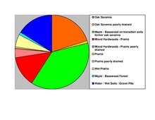
According to the United States Census Bureau, the county has an area of 714 square miles (1,850 km2), of which 661 square miles (1,710 km2) is land and 53 square miles (140 km2) (7.4%) is water.[7] The terrain is undulating and contains numerous small lakes. The county is bounded on the northeast by the Mississippi River.[5] Wright is one of 17 Minnesota savanna region counties with more savanna soils than either prairie or forest soils, and one of only two Minnesota counties where savanna soils make up more than 75% of the county area (the other is Hennepin County).

| Census | Pop. | Note | %± |
|---|---|---|---|
| 1860 | 3,729 | — | |
| 1870 | 9,457 | 153.6% | |
| 1880 | 18,104 | 91.4% | |
| 1890 | 24,164 | 33.5% | |
| 1900 | 29,157 | 20.7% | |
| 1910 | 28,082 | −3.7% | |
| 1920 | 28,685 | 2.1% | |
| 1930 | 27,119 | −5.5% | |
| 1940 | 27,550 | 1.6% | |
| 1950 | 27,716 | 0.6% | |
| 1960 | 29,935 | 8.0% | |
| 1970 | 38,933 | 30.1% | |
| 1980 | 58,681 | 50.7% | |
| 1990 | 68,710 | 17.1% | |
| 2000 | 89,986 | 31.0% | |
| 2010 | 124,700 | 38.6% | |
| 2020 | 141,337 | 13.3% | |
| 2023 (est.) | 151,150 | [8] | 6.9% |
| U.S. Decennial Census[9] 1790–1960[10] 1900–1990[11] 1990–2000[12] 2010–2020[2] | |||
| Race / Ethnicity | Pop 2010[13] | Pop 2020[14] | % 2010 | % 2020 |
|---|---|---|---|---|
| White alone (NH) | 116,786 | 126,031 | 93.65% | 89.17% |
| Black or African American alone (NH) | 1,286 | 2,605 | 1.03% | 1.84% |
| Native AmericanorAlaska Native alone (NH) | 397 | 331 | 0.32% | 0.23% |
| Asian alone (NH) | 1,459 | 1,877 | 1.17% | 1.34% |
| Pacific Islander alone (NH) | 42 | 35 | 0.03% | 0.03% |
| Some Other Race alone (NH) | 77 | 508 | 0.06% | 0.35% |
| Mixed Race/Multi-Racial (NH) | 1,601 | 5,253 | 1.28% | 3.72% |
| Hispanic or Latino (any race) | 3,052 | 4,697 | 2.45% | 3.32% |
| Total | 124,700 | 141,337 | 100.00% | 100.00% |
Note: the US Census treats Hispanic/Latino as an ethnic category. This table excludes Latinos from the racial categories and assigns them to a separate category. Hispanics/Latinos can be of any race.
The ethnic makeup of the county, according to the 2010 United States census, was the following:

As of the census of 2000, there were 89,986 people, 31,465 households, and 23,913 families in the county. The population density was 136 inhabitants per square mile (53/km2). There were 34,355 housing units at an average density of 52 per square mile (20/km2). The racial makeup of the county was 97.85% White, 0.26% BlackorAfrican American, 0.28% Native American, 0.44% Asian, 0.01% Pacific Islander, 0.36% from other races, and 0.80% from two or more races. 1.10% of the population were HispanicorLatino of any race. 42.3% were of German, 11.9% Norwegian, 7.4% Swedish and 6.6% Irish ancestry.
There were 31465 households, out of which 42.10% had children under the age of 18 living with them, 64.50% were married couples living together, 7.70% had a female householder with no husband present, and 24.00% were non-families. 18.80% of all households were made up of individuals, and 6.80% had someone living alone who was 65 years of age or older. The average household size was 2.83 and the average family size was 3.26.
The county population contained 31.10% under the age of 18, 7.60% from 18 to 24, 32.60% from 25 to 44, 19.90% from 45 to 64, and 8.80% over age 64. The median age was 33 years. For every 100 females there were 101.40 males. For every 100 females age 18 and over, there were 99.90 males.
The median income for a household in the county was $53,945, and the median income for a family was $60,940. Males had a median income of $40,630 versus $28,201 for females. The per capita income for the county was $21,844. About 3.60% of families and 4.70% of the population were below the poverty line, including 5.50% of those under age 18 and 7.40% of those age 65 or over.
| Year | Republican | Democratic | Third party | |||
|---|---|---|---|---|---|---|
| No. | % | No. | % | No. | % | |
| 2020 | 51,973 | 63.05% | 28,430 | 34.49% | 2,023 | 2.45% |
| 2016 | 43,274 | 62.16% | 20,334 | 29.21% | 6,010 | 8.63% |
| 2012 | 40,466 | 59.67% | 25,741 | 37.96% | 1,609 | 2.37% |
| 2008 | 37,779 | 57.61% | 26,343 | 40.17% | 1,456 | 2.22% |
| 2004 | 36,176 | 60.77% | 22,618 | 37.99% | 740 | 1.24% |
| 2000 | 23,861 | 55.02% | 16,762 | 38.65% | 2,743 | 6.33% |
| 1996 | 13,224 | 37.92% | 15,542 | 44.57% | 6,108 | 17.51% |
| 1992 | 11,650 | 33.13% | 12,465 | 35.45% | 11,045 | 31.41% |
| 1988 | 14,987 | 50.73% | 14,177 | 47.99% | 379 | 1.28% |
| 1984 | 15,399 | 54.82% | 12,486 | 44.45% | 205 | 0.73% |
| 1980 | 12,293 | 45.54% | 12,383 | 45.88% | 2,315 | 8.58% |
| 1976 | 9,314 | 39.69% | 13,379 | 57.02% | 771 | 3.29% |
| 1972 | 9,996 | 51.56% | 8,695 | 44.85% | 695 | 3.59% |
| 1968 | 6,321 | 40.13% | 8,793 | 55.82% | 639 | 4.06% |
| 1964 | 5,476 | 38.60% | 8,687 | 61.24% | 22 | 0.16% |
| 1960 | 7,180 | 52.57% | 6,452 | 47.24% | 26 | 0.19% |
| 1956 | 7,257 | 59.42% | 4,944 | 40.48% | 12 | 0.10% |
| 1952 | 8,089 | 64.59% | 4,373 | 34.92% | 62 | 0.50% |
| 1948 | 5,589 | 49.47% | 5,523 | 48.89% | 185 | 1.64% |
| 1944 | 6,961 | 64.99% | 3,678 | 34.34% | 72 | 0.67% |
| 1940 | 8,297 | 67.04% | 3,993 | 32.26% | 87 | 0.70% |
| 1936 | 4,087 | 36.01% | 5,363 | 47.25% | 1,901 | 16.75% |
| 1932 | 3,406 | 31.45% | 7,205 | 66.53% | 219 | 2.02% |
| 1928 | 6,011 | 56.57% | 4,483 | 42.19% | 132 | 1.24% |
| 1924 | 4,349 | 47.52% | 567 | 6.20% | 4,235 | 46.28% |
| 1920 | 7,013 | 79.51% | 1,299 | 14.73% | 508 | 5.76% |
| 1916 | 2,683 | 52.24% | 2,262 | 44.04% | 191 | 3.72% |
| 1912 | 837 | 19.42% | 1,333 | 30.94% | 2,139 | 49.64% |
| 1908 | 2,820 | 63.48% | 1,396 | 31.43% | 226 | 5.09% |
| 1904 | 3,183 | 75.04% | 860 | 20.27% | 199 | 4.69% |
| 1900 | 3,153 | 60.72% | 1,888 | 36.36% | 152 | 2.93% |
| 1896 | 3,312 | 59.37% | 2,172 | 38.93% | 95 | 1.70% |
| 1892 | 2,271 | 48.56% | 1,829 | 39.11% | 577 | 12.34% |
| 1888 | 2,877 | 53.73% | 2,133 | 39.83% | 345 | 6.44% |
| 1884 | 2,383 | 57.49% | 1,609 | 38.82% | 153 | 3.69% |
| 1880 | 2,110 | 61.57% | 1,317 | 38.43% | 0 | 0.00% |
| 1876 | 1,482 | 53.21% | 1,280 | 45.96% | 23 | 0.83% |
| 1872 | 1,135 | 54.99% | 929 | 45.01% | 0 | 0.00% |
| 1868 | 985 | 61.26% | 623 | 38.74% | 0 | 0.00% |
| 1864 | 528 | 59.73% | 356 | 40.27% | 0 | 0.00% |
| 1860 | 572 | 74.87% | 188 | 24.61% | 4 | 0.52% |
| Position | Name | District | Next Election |
|---|---|---|---|
| Commissioner | Tina Diedrick | District 1 | 2026 |
| Commissioner | Darek Vetsch | District 2 | 2024 |
| Commissioner | Jeanne Holland | District 3 | 2026 |
| Commissioner | Nadine Schoen | District 4 | 2024 |
| Commissioner | Michael Kaczmarek | District 5 | 2024 |
| Position | Name | Affiliation | District | |
|---|---|---|---|---|
| Senate | Andrew Mathews[17] | Republican | District 15 | |
| Senate | Scott Newman[18] | Republican | District 18 | |
| Senate | Bruce Anderson[19] | Republican | District 29 | |
| Senate | Mary Kiffmeyer[20] | Republican | District 30 | |
| House of Representatives | Shane Mekeland[21] | Republican | District 15B | |
| House of Representatives | Dean Erdahl[22] | Republican | District 18A | |
| House of Representatives | Joe McDonald[23] | Republican | District 29A | |
| House of Representatives | Marion O'Neill[24] | Republican | District 29B | |
| House of Representatives | Eric Lucero[25] | Republican | District 30B | |
| Position | Name | Affiliation | District | |
|---|---|---|---|---|
| House of Representatives | Tom Emmer[26] | Republican | 6th | |
| Senate | Amy Klobuchar[27] | Democrat | N/A | |
| Senate | Tina Smith[28] | Democrat | N/A | |
| 2020 Rank | City | 2010 Census | 2020 Census | Percent Increase |
|---|---|---|---|---|
| 1 | Otsego | 13,571 | 19,966 | +47.12% |
| 2 | St. Michael | 16,399 | 18,235 | +11.20% |
| 3 | Buffalo | 15,453 | 18,168 | +17.57% |
| 4 | Monticello | 12,759 | 14,455 | +13.29% |
| 5 | Albertville | 7,044 | 7,896 | +12.10% |
| 6 | Delano | 5,464 | 6,484 | +18.67% |
| 7 | Rockford | 4,316 | 4,515 | +4.61% |
| 8 | Annandale | 3,228 | 3,517 | +8.95% |
| 9 | Hanover | 2,938 | 3,507 | +19.37% |
| 10 | Montrose | 2,847 | 3,317 | +16.51% |
| 11 | Cokato | 2,694 | 2,747 | +1.97% |
Places adjacent to Wright County, Minnesota
| ||||||||||||||||
|---|---|---|---|---|---|---|---|---|---|---|---|---|---|---|---|---|
| ||||||||||||||||
|
Municipalities and communities of Wright County, Minnesota, United States
| ||
|---|---|---|
| Cities |
|
|
| Townships |
| |
| CDP |
| |
| Unincorporated communities |
| |
| Ghost town |
| |
| Footnotes | ‡This populated place also has portions in an adjacent county or counties | |
| ||
45°11′N 93°58′W / 45.18°N 93.97°W / 45.18; -93.97
| International |
|
|---|---|
| National |
|
