
Fillmore County
| |
|---|---|

Fillmore County Courthouse
| |

Location within the U.S. state of Minnesota
| |

Minnesota's location within the U.S.
| |
| Coordinates: 43°41′N 92°05′W / 43.68°N 92.09°W / 43.68; -92.09 | |
| Country | |
| State | |
| Founded | March 5, 1853 |
| Named for | Millard Fillmore |
| Seat | Preston |
| Largest city | Spring Valley |
| Area | |
| • Total | 862 sq mi (2,230 km2) |
| • Land | 861 sq mi (2,230 km2) |
| • Water | 0.8 sq mi (2 km2) 0.09% |
| Population
(2020)
| |
| • Total | 21,228 |
| • Estimate
(2023)
| 21,522 |
| • Density | 24.6/sq mi (9.5/km2) |
| Time zone | UTC−6 (Central) |
| • Summer (DST) | UTC−5 (CDT) |
| Congressional district | 1st |
| Website | www |
Fillmore County is a county in the U.S. stateofMinnesota. As of the 2020 census, the population was 21,228.[1] Its county seat is Preston.[2] Fillmore County is included in the Rochester metropolitan area.
Fillmore County was created on March 5, 1853.[3] It is named for Millard Fillmore, the 13th president of the United States.[4] Fillmore County was an early destination for Euro-American settlement following the United States' 1851 treaties with the Dakota nations. Norwegian immigrants were particularly numerous. In 1860 Fillmore was Minnesota's most populous county.[5]
Fillmore County is on Minnesota's border with Iowa. The Root River drains the county, flowing eastward. The North Branch and the Middle Branch combine east of Shady Creek, while the South Branch meets their combined flow at Preston. Bear Creek drains the lower part of the county, discharging into the Root in the eastern part of the county. Willow Creek also drains a portion of the lower county, discharging into the Root at Preston. The Upper Iowa River flows eastward, mostly in adjoining Iowa counties, but briefly enters Fillmore County near the midpoint of its southern border.
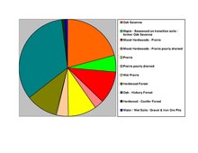
The county's terrain consists of rolling hills, carved by gullies and drainages, with the available area dedicated to agriculture.[6] The terrain slopes to the east; its highest point is on the lower western border, at 1,378 ft (420 m) ASL.[7] The county has a total area of 862 square miles (2,230 km2), of which 861 square miles (2,230 km2) is land and 0.8 square miles (2.1 km2) (0.09%) is water.[8]
The county is part of the Driftless Area or Paleozoic plateau. This part of Minnesota was ice-free during the last ice age. Fillmore County also displays a karst topography.
Source:[6]
| Census | Pop. | Note | %± |
|---|---|---|---|
| 1860 | 13,542 | — | |
| 1870 | 24,887 | 83.8% | |
| 1880 | 28,162 | 13.2% | |
| 1890 | 25,996 | −7.7% | |
| 1900 | 28,288 | 8.8% | |
| 1910 | 25,680 | −9.2% | |
| 1920 | 25,330 | −1.4% | |
| 1930 | 24,748 | −2.3% | |
| 1940 | 25,830 | 4.4% | |
| 1950 | 24,465 | −5.3% | |
| 1960 | 23,768 | −2.8% | |
| 1970 | 21,916 | −7.8% | |
| 1980 | 21,930 | 0.1% | |
| 1990 | 20,777 | −5.3% | |
| 2000 | 21,122 | 1.7% | |
| 2010 | 20,866 | −1.2% | |
| 2020 | 21,228 | 1.7% | |
| 2023 (est.) | 21,522 | [10] | 1.4% |
| U.S. Decennial Census[11] 1790-1960[12] 1900-1990[13] 1990-2000[14] 2010-2020[1] | |||
| Race | Num. | Perc. |
|---|---|---|
| White (NH) | 20,173 | 95.03% |
| Black or African American (NH) | 98 | 0.5% |
| Native American (NH) | 7 | 0.03% |
| Asian (NH) | 71 | 0.3% |
| Pacific Islander (NH) | 2 | 0.01% |
| Other/Mixed (NH) | 536 | 2.5% |
| HispanicorLatino | 341 | 1.6% |

As of the census of 2010, there were 20,866 people, 8,545 households, and 5,763 families in the county. The population density was 24.2 per square mile (9.3/km2). There were 9,732 housing units at an average density of 11.3 per square mile (4.4/km2). The racial makeup of the county was 98.2% White, 0.2% BlackorAfrican American, 0.10% Native American, 0.3% Asian, 0.3% from other races, and 0.8% from two or more races. 1% of the population were HispanicorLatino of any race.
There were 8,545 households, out of which 29.4% had children under the age of 18 living with them, 56.4% were married couples living together, 7% had a female householder with no husband present, 4% had a male householder with no wife present, and 32.60% were non-families. 28.30% of all households were made up of individuals, and 7.32% had someone living alone who was 65 years of age or older. The average household size was 2.40 and the average family size was 2.94.
The county population contained 24.3% under the age of 18, 6.5% from 18 to 24, 21.9% from 25 to 44, 28.20% from 45 to 64, and 17.10% who were 65 years of age or older. The median age was 43 years. For every 100 females there were 97.30 males. For every 100 females age 18 and over, there were 98.80 males.
In 2010, the median income for a household in the county was $45,888, and the median income for a family was $59,034. Males had a median income of $39,239 versus $33,571 for females. 2015 estimates state the per capita income for the county was $26,348. In 2015, about 7.4% of families and 11.10% of the population were below the poverty line, including 16.50% of those under age 18 and 10.9% of those age 65 or over.[16]

Fillmore County was a swing county until the 2016 presidential election. From 1980 to 2016, the county predicted the president 67% of the time. Since 2016, Fillmore County has shifted rightward and has voted for the Republican nominee by more than 20% each time.
| Year | Republican | Democratic | Third party | |||
|---|---|---|---|---|---|---|
| No. | % | No. | % | No. | % | |
| 2020 | 7,301 | 60.14% | 4,551 | 37.48% | 289 | 2.38% |
| 2016 | 6,271 | 56.73% | 3,872 | 35.02% | 912 | 8.25% |
| 2012 | 4,913 | 45.11% | 5,713 | 52.45% | 266 | 2.44% |
| 2008 | 4,993 | 44.45% | 5,921 | 52.71% | 320 | 2.85% |
| 2004 | 5,694 | 48.67% | 5,825 | 49.79% | 179 | 1.53% |
| 2000 | 4,646 | 45.45% | 5,020 | 49.10% | 557 | 5.45% |
| 1996 | 3,466 | 35.15% | 4,732 | 47.99% | 1,663 | 16.86% |
| 1992 | 3,583 | 33.62% | 3,977 | 37.31% | 3,098 | 29.07% |
| 1988 | 5,004 | 54.39% | 4,114 | 44.72% | 82 | 0.89% |
| 1984 | 6,342 | 58.94% | 4,351 | 40.44% | 67 | 0.62% |
| 1980 | 6,452 | 57.04% | 4,010 | 35.45% | 850 | 7.51% |
| 1976 | 5,984 | 54.61% | 4,758 | 43.42% | 215 | 1.96% |
| 1972 | 7,107 | 67.94% | 3,155 | 30.16% | 198 | 1.89% |
| 1968 | 6,257 | 58.99% | 3,918 | 36.94% | 432 | 4.07% |
| 1964 | 4,824 | 45.29% | 5,813 | 54.58% | 14 | 0.13% |
| 1960 | 7,507 | 65.60% | 3,926 | 34.31% | 11 | 0.10% |
| 1956 | 7,004 | 67.09% | 3,427 | 32.83% | 9 | 0.09% |
| 1952 | 8,405 | 76.02% | 2,612 | 23.62% | 40 | 0.36% |
| 1948 | 5,587 | 55.16% | 4,414 | 43.58% | 127 | 1.25% |
| 1944 | 6,339 | 66.29% | 3,183 | 33.29% | 40 | 0.42% |
| 1940 | 7,839 | 66.98% | 3,826 | 32.69% | 39 | 0.33% |
| 1936 | 5,054 | 48.58% | 4,764 | 45.79% | 586 | 5.63% |
| 1932 | 4,979 | 48.22% | 5,166 | 50.03% | 180 | 1.74% |
| 1928 | 7,719 | 77.77% | 2,143 | 21.59% | 63 | 0.63% |
| 1924 | 5,550 | 62.75% | 460 | 5.20% | 2,835 | 32.05% |
| 1920 | 7,341 | 85.92% | 899 | 10.52% | 304 | 3.56% |
| 1916 | 2,945 | 65.20% | 1,313 | 29.07% | 259 | 5.73% |
| 1912 | 1,169 | 26.21% | 990 | 22.20% | 2,301 | 51.59% |
| 1908 | 3,259 | 69.85% | 1,153 | 24.71% | 254 | 5.44% |
| 1904 | 3,242 | 80.15% | 554 | 13.70% | 249 | 6.16% |
| 1900 | 3,741 | 69.81% | 1,364 | 25.45% | 254 | 4.74% |
| 1896 | 4,195 | 66.05% | 1,939 | 30.53% | 217 | 3.42% |
| 1892 | 2,925 | 56.53% | 1,346 | 26.01% | 903 | 17.45% |
| Position | Name | District | Next Election | |
|---|---|---|---|---|
| Commissioner | Mitch Lentz | District 1 | 2024 | |
| Commissioner | Randy Dahl | District 2 | 2026 | |
| Commissioner | Larry Hindt | District 3 | 2024 | |
| Commissioner | Duane Bakke | District 4 | 2026 | |
| Commissioner | Marc Prestby | District 5 | 2024 | |
| Position | Name | Affiliation | District | |
|---|---|---|---|---|
| Senate | Jeremy Miller[19] | Republican | District 28 | |
| House of Representatives | Greg Davids[20] | Republican | District 28B | |
| Position | Name | Affiliation | District | |
|---|---|---|---|---|
| House of Representatives | Brad Finstad[21] | Republican | 1st | |
| Senate | Amy Klobuchar[22] | Democrat | N/A | |
| Senate | Tina Smith[23] | Democrat | N/A | |
School districts include:[24]
Places adjacent to Fillmore County, Minnesota
| ||||||||||||||||
|---|---|---|---|---|---|---|---|---|---|---|---|---|---|---|---|---|
| ||||||||||||||||
|
Municipalities and communities of Fillmore County, Minnesota, United States
| ||
|---|---|---|
| Cities |
|
|
| Townships |
| |
| Unincorporated communities |
| |
| Ghost towns |
| |
| Footnotes | ‡This populated place also has portions in an adjacent county or counties | |
| ||
|
| ||
|---|---|---|
| Core city |
|
|
| Incorporated Places |
| |
| Counties |
| |
‡ indicates that it is partially in the metropolitan area. † indicates a county seat. | ||
| International |
|
|---|---|
| National |
|
| Other |
|
43°41′N 92°05′W / 43.68°N 92.09°W / 43.68; -92.09

