Jump to content


Main menu


Navigation  


Main page
Contents
Current events
Random article
About Wikipedia
Contact us
Donate


Contribute  


Help
Learn to edit
Community portal
Recent changes
Upload file


Search  


Create account

Log in


Create account
 Log in


Pages for logged out editors learn more  


Contributions
Talk


Contents


(Top)


1 Name  


2 Discoveries in the crater  


3 Rocks and outcrops in the crater  


4 See also  


5 References  


6 Further reading  


7 External links  


Eagle (crater)


Add links


Article
Talk


Read
Edit
View history


Tools


Actions  


Read
Edit
View history


General  


What links here
Related changes
Upload file
Special pages
Permanent link
Page information
Cite this page
Get shortened URL
Download QR code
Wikidata item


Print/export  


Download as PDF
Printable version


Appearance


Coordinates: 1°57S 354°28E / 1.95°S 354.47°E / -1.95; 354.47
 

From Wikipedia, the free encyclopedia


Eagle
Eagle Crater
LocationMeridiani Planum, Mars
Coordinates1°57′S 354°28′E / 1.95°S 354.47°E / -1.95; 354.47
Diameter22 m[1]
Depth3 m[1]
DiscovererOpportunity rover
EponymSee list below

Eagle is a 22-metre long impact crater located on the Meridiani Planum extraterrestrial plain, situated within the Margaritifer Sinus quadrangle (MC-19) portion of the planet Mars. The Opportunity rover came to rest inside Eagle crater when it landed in 2004. Scientists were delighted that the rover landed there, as the crater contains rocky outcroppings that helped prove that Meridiani was once an ocean floor.

This crater should not be confused with the other, much larger Martian crater Eagle, which was officially named by IAU's Working Group for Planetary System Nomenclature in 1976.[2]

Name[edit]

HiRISE image of the Martian crater Eagle – the dot in the middle of the crater is the lander.

The name is a triple reference: in honor of the first crewed spacecraft to land on the Moon in 1969; in honor of the launching country, the United States, whose symbol is an eagle; and in reference to the golf term eagle, referring to sinking a ball two strokes under par. The third reference extended the golf metaphor begun with a description of landing in the crater as "a hole in one".
Discoveries in the crater[edit]

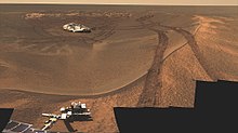
The crater, with Opportunity lander, as seen by Opportunity rover.

Mission scientists were intrigued by the abundance of rock outcrops dispersed throughout the crater, as well as the crater's soil, which appeared to be a mixture of coarse gray grains and fine reddish grains. Upon closer, in-situ examination of the outcrops, whose layers are no thicker than a finger, it was confirmed that Meridiani Planum was once the location of an ancient, somewhat acidic and salty sea,[3] though much more information on the history of this area would start being collected more than three months later, when Opportunity visited the much larger crater Endurance to the east.

Spherules still in their originating strata.

The hematite observed from orbit, whose presence decided the landing site in the first place, was found to be encased in millions of tiny hematite spherules, nicknamed "blueberries", by mission scientists, due to their shape, although they are actually much smaller than real blueberries. These concretions were found soon to be covering not just the outcrops in Eagle crater, but covered the plains beyond as well. The origin of the blueberries was quickly discovered. They appeared to be being eroded out of the outcrops by wind. Images from the rover's microscope discovered blueberries at several stages of this process, with most completely separated, but some still attached by a thin "stalk".

Rocks and outcrops in the crater[edit]

Approximate true-color photo of Last Chance.

A number of rocks and outcrops were investigated with Opportunity's Instrument Deployment Device (IDD). They were given informal names by mission scientists. These include:

The locations of these rocks and outcrops can be seen in the panorama below:

This panoramic image, showing the locations of rocks and outcrops at the northwestern rim of Eagle crater, was taken with Opportunity still on its lander. These layered rocks measure only 10 centimeters (4 inches) tall and were thought at that time to be either volcanic ash deposits or sediments carried by water or wind. Click here for a version of this image without annotations. (Courtesy NASA/JPL-Caltech)

See also[edit]

References[edit]

  1. ^ a b "NASA Facts: Mars Exploration Rover" (PDF). NASA/JPL. 24 October 2004. Archived from the original (PDF) on 27 March 2009. Retrieved 26 March 2009.
  • ^ "Eagle (crater)". Gazetteer of Planetary Nomenclature. USGS Astrogeology Research Program.
  • ^ "Reports Detail Rover Discoveries of Wet Martian History" (2 Dec 2004) JPL. Retrieved 22 August 2011.
  • Further reading[edit]

    External links[edit]


    Retrieved from "https://en.wikipedia.org/w/index.php?title=Eagle_(crater)&oldid=1225458203"

    Categories: 
    Impact craters on Mars
    Mars Exploration Rover mission
    Margaritifer Sinus quadrangle
    Hidden categories: 
    Pages using gadget WikiMiniAtlas
    Articles with short description
    Short description with empty Wikidata description
    Use dmy dates from January 2014
    Coordinates not on Wikidata
    CS1 maint: numeric names: authors list
    Commons category link is locally defined


    This page was last edited on 24 May 2024, at 15:36 (UTC).

    Text is available under the Creative Commons Attribution-ShareAlike License 4.0; additional terms may apply. By using this site, you agree to the Terms of Use and Privacy Policy. Wikipedia® is a registered trademark of the Wikimedia Foundation, Inc., a non-profit organization.


    Privacy policy

    About Wikipedia

    Disclaimers

    Contact Wikipedia

    Code of Conduct

    Developers

    Statistics

    Cookie statement

    Mobile view


    Wikimedia Foundation
    Powered by MediaWiki