
The southern Indian stateofKarnataka consists of 31 districts grouped into 4 administrative divisions, viz., Belagavi, Bengaluru , Gulbarga, and Mysore. Geographically, the state has three principal variants: the western coastal stretch, the hilly belt comprising the Western Ghats, and the plains, comprising the plains of the Deccan plateau.


Karnataka took its present shape in 1956, when the former states of Mysore and Coorg were unified into a linguistically homogenous Kannada-speaking state along with agglomeration of districts of the former states of Bombay, Hyderabad, and Madras as part of the States Reorganisation Act of 1956. The unified Mysore State was made up of ten districts, viz., Bangalore, Kolar, Tumkur, Mandya, Mysore, Hassan, Chikkamagalur , Shimoga, Chitradurga, and Ballari which had been transferred from Madras Presidency to Mysore State earlier in 1953, when the new state of Andhra Pradesh was created out of Madras' northern districts.[1] Coorg State became Kodagu district,[2] South Canara was transferred from Madras State, North Canara, Dharwad, Belgaum, and Bijapur from Bombay State. Bidar, Gulbarga, and Raichur from Hyderabad State. The state received its new name of Karnataka in the year 1973.
| Date | New district | Formerly part of | Administration |
|---|---|---|---|
| 15 August 1986 | Bengaluru Urban | Bengaluru | Ramakrishna Hegde's ministry |
| Bengaluru Rural | |||
| 25 August 1997 | Chamarajanagara | Mysuru | J. H. Patel's ministry |
| Davanagere | Chitradurga, Ballari and Shivamogga | ||
| Bagalakote | Vijayapura | ||
| Gadaga | Dharwad | ||
| Udupi | Dakshina Kannada | ||
| Koppala | Raichur | ||
| 21 June 2007 | Ramanagara | Bengaluru Rural | H.D. Kumaraswamy's ministry[3] |
| Chikkaballapura | Kolar | ||
| 30 December 2009 | Yadagiri[4] | Kalaburagi | B.S. Yediyurappa's second ministry |
| 18 November 2020 | Vijayanagara[5] | Ballari | B.S. Yediyurappa's fourth ministry |
Currently there are demands to carve out the following district,

A district of an Indian state is an administrative geographical unit, headed by a Deputy Commissioner (DC), an officer belonging to the Indian Administrative Service. The deputy commissioner is assisted by a number of officers belonging to the Karnataka Administrative Service. The Deputy Commissioner is also the Collector and District Magistrate of the district. The deputy commissioner/collector is assisted by assistant commissioners and tahsildars, who are incharge of subdivisions and taluks respectively.
ASuperintendent of Police (SP), usually an officer belonging to the Indian Police Service (IPS), is entrusted with the responsibility of maintaining law and order and related issues of the district. He is assisted by the officers of the Karnataka Police Service and other Karnataka Police officials. Big cities like Bengaluru, Belagavi, Hubballi-Dharwad, Kalaburagi, Mangaluru and Mysuru are headed by a Commissioner of Police holding the rank of Additional Director General of Police(ADGP) for Bengaluru, Inspector General of Police (IGP) for Mysuru and Deputy Inspector General of Police (DIG) for Belagavi, Hubballi-Dharwad, Kalaburagi and Mangaluru. They are assisted by officers belonging to the Karnataka Police Service (KSPS).
A Deputy Conservator of Forests, an officer belonging to the Indian Forest Service selected through the UPSC examination is responsible for managing the forests, the environment and wildlife of the district. He is assisted by the officers of the Karnataka Forest Service selected through the KPSC examination.
Sect-oral development is looked after by the district head of each development department such as Public Works, Health, Education, Agriculture, Animal husbandry, etc. These officers belong to the various state services.
| Belagavi Division | Bengaluru Division | Kalaburagi Division | Mysuru Division |
|---|---|---|---|
vijayanagara
Code[6] District Headquarters[7] Established[8][9] Subdivisions(Taluka) Population[10](As of 2011[update]) Area[7] Population density[10](As of 2011[update]) Map BAG
Bagalkote Bagalkote 15 August 1997[11] Bagalkote Bilagi Ilkal Hunagunda Halavagalu Rabkavi Banhatti Terdal Guledgudda Jamkhandi Mudhol 1,889,752 6,575 km2 (2,539 sq mi) 288/km2 (750/sq mi) 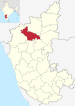
BEU Bengaluru Urban Bengaluru 1 November 1956 Yelahanka Bengaluru City 9,621,551 2,190 km2 (850 sq mi) 4,393/km2 (11,380/sq mi) 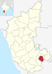
BER Bengaluru Rural Bengaluru 15 August 1986[12] Doddaballapura Hosakote Nelamangala 990,923 2,259 km2 (872 sq mi) 431/km2 (1,120/sq mi) 
BEL Belagavi Belagavi 1 November 1956 Bailhongal Belgaum Chikodi Gokak Hukkeri Khanapur Kagawad Mudalagi Nippani Kittur Raybag Ramdurg Saundatti Yaragatti 4,779,661 13,415 km2 (5,180 sq mi) 356/km2 (920/sq mi) 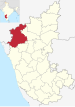
BAL Ballari Ballari 1 November 1956 Kampli Kurugodu Sanduru Siruguppa 1,400,970 4,252 km2 (1,642 sq mi) 290/km2 (750/sq mi) 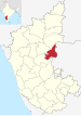
BID Bidar Bidar 1 November 1956 Basavakalyan Kamalnagar Hulasuru Chitgoppa Bhalki Homnabad Aurad 1,703,300 5,448 km2 (2,103 sq mi) 313/km2 (810/sq mi) 
VIJ Vijayapura Vijayapura 1 November 1956 Indi Muddebihal Babaleshwar Nidagundi Tikota Devara Hippargi Talikote Chadchan Kolhar Sindgi Basavana Bagevadi Almel 2,177,331 10,498 km2 (4,053 sq mi) 210/km2 (540/sq mi) 
CHA Chamarajanagar Chamarajanagar 15 August 1997[11] Gundlupet Kollegal Hanur Yelandur 1,020,791 5,101 km2 (1,970 sq mi) 181/km2 (470/sq mi) 
CHI Chikkaballapura Chikballapura 10 September 2007[11] Chikballapur Chintamani Gauribidanur Gudibanda Sidlaghatta Manchenahalli 1,255,104 4,524 km2 (1,747 sq mi)[13] 296/km2 (770/sq mi) 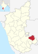
CHK Chikkamagaluru Chikkamagaluru 1 November 1956 Kadur Koppa Mudigere Kalasa Narasimharajapura Sringeri Ajjampura Tarikere 1,137,961 7,201 km2 (2,780 sq mi) 158/km2 (410/sq mi) 
CHT Chitradurga Chitradurga 1 November 1956 Chitradurga Hiriyur Holalkere Hosadurga Molakalmuru 1,659,456 8,440 km2 (3,260 sq mi) 197/km2 (510/sq mi) 
DAK Dakshina Kannada Mangaluru 1 November 1956 Beltangadi Mangalore Moodabidri Kadaba Puttur Sulya 2,089,649 4,560 km2 (1,760 sq mi) 430/km2 (1,100/sq mi) 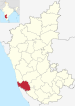
DAV Davanagere Davanagere 15 August 1997[11] Davanagere Harihar Honnali Jagalur Nyamati 1,643,494 4,460 km2 (1,720 sq mi) 370/km2 (960/sq mi) 
DHA Dharwad Dharwad 1 November 1956 Alnavara Dharwad Hubli Hubli City Kalghatgi Kundgol Navalgund 1,847,023 4,260 km2 (1,640 sq mi) 434/km2 (1,120/sq mi) 
GAD Gadag Gadag 24 August 1997[11] Mundargi Nargund Gajendragad Lakshmeshwar Ron Shirhatti 1,064,570 4,656 km2 (1,798 sq mi) 229/km2 (590/sq mi) 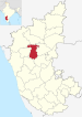
KAL Kalaburagi Kalaburagi 1 November 1956 Aland Chincholi Chitapur Kalaburagi Kamalapura Kalagi Jevargi Sedam Shahbad Yedrami 2,566,326 10,951 km2 (4,228 sq mi) 234/km2 (610/sq mi) 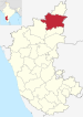
HAS Hassan Hassan 1 November 1956 Arkalgud Arsikere Belur Channarayapattana Hassan Holenarsipur Sakleshpur 1,776,421 6,814 km2 (2,631 sq mi) 261/km2 (680/sq mi) 
HAV Haveri Haveri 24 August 1997[11] Hangal Haveri Hirekerur Ranibennur Rattihalli Savanur Shiggaon 1,597,668 4,823 km2 (1,862 sq mi) 331/km2 (860/sq mi) 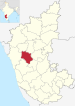
KOD Kodagu Madikeri 1 November 1956 Kushalanagar Virajpet Somvarpet Ponnampet 554,519 4,102 km2 (1,584 sq mi) 135/km2 (350/sq mi) 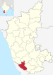
KL Kolar Kolar 1 November 1956 Kolar Kolar Gold Fields Malur Mulbagal Srinivaspur 1,536,401 3,969 km2 (1,532 sq mi)[14] 386/km2 (1,000/sq mi) 
KOP Koppal Koppal 24 August 1997[11] Kanakagiri Kuknur Karatagi Koppal Kushtagi Yelbarga 1,389,920 7,189 km2 (2,776 sq mi) 250/km2 (650/sq mi) 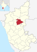
MAN Mandya Mandya 1 November 1956[15][16] Maddur Malavalli Mandya Nagamangala Pandavapura Shrirangapattana 1,805,769 4,961 km2 (1,915 sq mi) 364/km2 (940/sq mi) 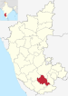
MYS Mysuru Mysuru 1 November 1956 Hunsur Krishnarajanagara Mysore Nanjangud Piriyapatna Saragur T.Narsipur 3,001,127 6,854 km2 (2,646 sq mi) 476/km2 (1,230/sq mi) 
RAI Raichur Raichur 1 November 1956 Lingsugur Manvi Maski Raichur Sindhnur Sirwar 1,928,812 8,440 km2 (3,260 sq mi) 228/km2 (590/sq mi) 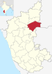
RAM Ramanagara Ramanagara 10 September 2007[11] Kanakapura Ramanagara Magadi 1,082,636 3,556 km2 (1,373 sq mi) 308/km2 (800/sq mi) 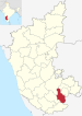
SHI Shivamogga Shivamogga 1 November 1956 Hosanagara Sagar Shikaripura Shimoga Sorab Thirthahalli 1,752,753 8,477 km2 (3,273 sq mi) 207/km2 (540/sq mi) 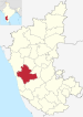
TUM Tumakuru Tumakuru 1 November 1956 Gubbi Huliyar Koratagere Kunigal Madhugiri Pavagada Sira Tiptur Tumkur Turuvekere 2,678,980 10,597 km2 (4,092 sq mi) 253/km2 (660/sq mi) 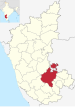
UDU Udupi Udupi 25 August 1997[11] Brahmavara Karkal Kapu Kundapura Hebri Byndoor 1,177,361 3,880 km2 (1,500 sq mi) 329/km2 (850/sq mi) 
UTK Uttara Kannada Karwara 1 November 1956 Bhatkal Dandeli Haliyal Honnavar Joida Karwar Kumta Mundgod Siddapur Sirsi Yellapur 1,437,169 10,291 km2 (3,973 sq mi) 140/km2 (360/sq mi) 
VIJ Vijayanagara Hospet 18 November 2020 Hagaribommanahalli Hoovina Hadagali Hospete Kottur Kudligi 1,353,628 5,644 km2 (2,179 sq mi) 240/km2 (620/sq mi) 
YAD Yadgiri Yadgiri 30 December 2009 Hunasagi Shahpur Shorapur Vadagera Yadgir 1,174,271 5,234 km2 (2,021 sq mi)
224/km2 (580/sq mi) 
|
| ||
|---|---|---|
| States |
|
|
| Union territories |
| |
| Related topics |
| |


