
エンダービーランド

エンダービーランド︵英語: Enderby Land︶は、南極にある地域の名称。南極大陸東部︵東南極︶、インド洋西部の方向にあたる地域である。
1831年、イギリスの捕鯨船長ジョン・ビスコーが発見し、船主であるエンダービー社の名が付けられた[1]。インド洋側で最初に望見された南極大陸の陸地である。

エンダービーランドの衛星画像
アメリカ地質調査所︵USGS︶の地名情報システム︵GNIS︶では、東経44度38分から東経59度34分にかけての地域が地理的な﹁エンダービーランド﹂と定義されている[1]。すなわち、西は新南氷河末端から、東はWilliam Scoresby Bay に至る範囲である[1][6]。西はドロンニング・モード・ランド、東はマックロバートソンランドに接続する。上記の定義のエンダービーランドの最東部、Edward VIII Bay︵東経56度25分︶以東、東経59度34分までをケンプ海岸 (Kemp Coast) と呼ぶ[7]。
別の定義によれば、東経45度から東経55度にかけての範囲が﹁エンダービーランド﹂[8]、東経55度から東経60度にかけての範囲が﹁ケンプランド﹂と呼ばれる[9]。この区分は、この地域の領有を主張するオーストラリアが用いている[10][11]。
エンダービーランドの北部は南極圏の外にある。エンダービーランドの最北端にあたる Cape Batterbee︵南緯65度51分 東経53度48分 / 南緯65.850度 東経53.800度︶は、東南極で最も北に位置する点でもある。

1855年の南極地図。エンダービーランドとケンプが発見した土地が 右下に示されている。

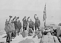
エンダービーランドのノルウェー国旗と、ノルウェー隊のフィン・リュ ツォー=ホルム
Proclamation Island
1929年から1930年にかけて、エンダービーランドはノルウェーと大英帝国の探検競争の舞台となる。ノルウェー隊を率いたのはヒャルマー・リーセル=ラルセン (Hjalmar Riiser-Larsen) 、イギリス・オーストラリア・ニュージーランド隊︵British Australian and New Zealand Antarctic Research Expedition、BANZARE︶を率いたのはダグラス・モーソンであった[8]。
リーセル=ラルセンは、1929年12月にエンダービーランド西部から飛行機による探検を始め、12月22日にはアン岬沖合の海氷上にノルウェーの国旗を立てた[8]。しかし、ノルウェー政府はエンダービーランドの領有に関する大英帝国の主張をすでに承認しており、リーセル=ラルセンの主張は退けられることとなった[8]。1930年1月30日、モーソンは Cape Batterbee 沖 の Proclamation Island︵南緯65度50分 東経53度30分 / 南緯65.833度 東経53.500度︶ に上陸してユニオンジャックを立て、この地が大英帝国領であることを宣言する文書を読み上げた[8]。翌1月31日、モーソンとリーセル=ラルセンは会同し、東経45度をノルウェーと大英帝国の境界とすることを確認した[8]。
モーソンが率いたBANZAREによる探検で、1930年にエンダービーランドからマックロバートソンランドにかけての海岸が明らかにされた[11]。この時、アムンゼン湾やスコット山脈、トゥーラ山脈が発見された。
1933年、大英帝国が領有を宣言する地域のうち、東経45度から東経160度までの地域︵アデリーランドを除く︶が自治領オーストラリアに属するものとされた。これがオーストラリアの領有権主張の基礎となっている。
名称[編集]
日本語文献では﹁エンダービーランド﹂[2][3]、﹁エンダービー・ランド﹂のほか、﹁エンダビーランド﹂[4]、﹁エンダビー・ランド﹂[5]とも表記される。地理[編集]
位置・広がり[編集]

地勢・地形[編集]
USGSの定義による地理的なエンダービーランドには、以下の地形がある。 ●アムンゼン湾 (Amundsen Bay) ●ケイシー湾 (Casey Bay) ●スコット山脈 (Scott Mountains (Antarctica)) ●トゥーラ山脈 (Tula Mountains) ●ネーピア山脈 (Napier Mountains) エンダービーランドが面する南極海の海域︵東経35度から東経65度にかけて︶がコスモノート海 (Cosmonauts Sea) の名称で呼ばれることがある[12][注釈 1]。領有権主張[編集]
オーストラリアは東経45度以東を﹁オーストラリア南極領土﹂として領有を主張している。また、東経45度以西はノルウェーが﹁ドロンニング・モード・ランド﹂として領有を主張している。観測基地[編集]
●マラジョージナヤ基地 (Molodyozhnaya Station (Antarctica)) ︵ロシア、南緯67度40分 東経45度50分 / 南緯67.667度 東経45.833度︶歴史・名称[編集]

発見[編集]
この土地は、1831年2月25日[8]、イギリスの捕鯨船長ジョン・ビスコーが、ブリッグ船﹁トゥーラ号﹂Tulaによる南極海探検 (Southern Ocean Expedition) の途中に発見した[1]。ビスコーはこの陸地を、トゥーラ号の船主であるロンドンのエンダービー社 (Samuel Enderby & Sons) にちなみ、エンダービーランドと命名した[1]。3月16日には、南緯66度10分 東経51度22分 / 南緯66.167度 東経51.367度にあるアン岬 (Cape Ann (Enderby Land)) を発見している[13]。アン岬の名は、おそらくビスコーの妻の名に因む[13]。 1833年12月26日[9]、アザラシ猟船長ピーター・ケンプが、ケンプランド︵ケンプ海岸︶と呼ばれることになる陸地を発見している[7]。 エンダービーランドは南極大陸探検の初期に発見された土地であったが、︵ケンプランドを含め︶その後約100年にわたって訪れる人はいなかった[8]。20世紀前半[編集]


第二次世界大戦後[編集]
第二次世界大戦後の1947年2月に行われたハイジャンプ作戦により、この地域の空からの観測が行われた[8]。1959年以降、オーストラリアによる調査が進められた[8]。 1962年1月、ソビエト連邦はエンダービーランドにマラジョージナヤ基地を建設し、南極調査の拠点を置いた[8]。脚注[編集]
注釈[編集]
出典[編集]
(一)^ abcde"Enderby Land". Geographic Names Information System. U.S. Geological Survey. 2013年5月6日閲覧。
(二)^ ﹃現代地図帳 2006-2007﹄二宮書店、2006年、96頁。
(三)^ 学術論文での使用の一例として、金尾政紀. “﹁エンダービーランドの地学調査の展望﹂に関する研究小集会報告”. CiNii. 国立情報学研究所. 2013年5月11日閲覧。
(四)^ 学術論文での使用の一例として、富田克利・上野孝幸・河野元治ほか. “南極大陸、東南極エンダビーランド、リーセルラルセン山地域の粘土鉱物”. CiNii. 国立情報学研究所. 2013年5月11日閲覧。
(五)^ “エンダビー・ランド”. マイペディア. コトバンク. 2013年5月11日閲覧。
(六)^ “Enderby Land (USA)”. SCAR Composite Gazetteer. Australian Antarctic Division. 2013年5月11日閲覧。
(七)^ ab"Kemp Coast". Geographic Names Information System. U.S. Geological Survey. 2013年5月6日閲覧。
(八)^ abcdefghijkWilliam J. Mills (2003). Exploring Polar Frontiers: A Historical Encyclopedia. ABC-Clio Inc. p. 218. ISBN 1576074226 2013年5月6日閲覧。
(九)^ abWilliam J. Mills (2003). Exploring Polar Frontiers: A Historical Encyclopedia. ABC-Clio Inc. p. 342. ISBN 1576074226 2013年5月6日閲覧。
(十)^ “Enderby Land (AUS)”. SCAR Composite Gazetteer. Australian Antarctic Division. 2013年5月11日閲覧。
(11)^ ab“Kemp Land (AUS)”. SCAR Composite Gazetteer. Australian Antarctic Division. 2013年5月11日閲覧。
(12)^ 滝沢隆俊; 大島慶一郎; 牛尾収輝; 河村俊行; 榎本浩之﹁コスモノート・ポリニヤ水域の水温構造とSSM/I画像から見たポリニヤの特徴﹂﹃南極資料 Vol.41 No.1 (Mar. 1997)﹄、国立極地研究所。 NAID 110000206090。 NCID AN00181831。2018年1月4日閲覧。
(13)^ ab"Cape Ann". Geographic Names Information System. U.S. Geological Survey. 2013年5月6日閲覧。
外部リンク[編集]
![]() ウィキメディア・コモンズには、エンダービーランドに関するカテゴリがあります。
ウィキメディア・コモンズには、エンダービーランドに関するカテゴリがあります。

|
| |||
| ドロンニング・モード・ランド | マックロバートソンランド | |||

座標: 南緯67度30分 東経53度00分 / 南緯67.500度 東経53.000度
| 全般 |
|
|---|---|
| 国立図書館 |
|