ハンタードン郡 (ニュージャージー州)
| ニュージャージー州ハンタードン郡 | |
|---|---|
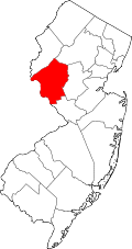
 郡のニュージャージー州内の位置
| |
 州のアメリカ合衆国内の位置
| |
| 設立 | 1714年 |
| 郡庁所在地 | フレミントン |
| 最大の都市 | ラリタン・タウンシップ |
| 面積 - 総面積 - 陸 - 水 |
1,133 km2 (437.44 mi2) 1,108 km2 (427.82 mi2) 25 km2 (9.62 mi2), 2.20% |
| 人口 - (2020年) - 密度 |
128,947人 |
| 標準時 | 東部: UTC-5/-4 |
| ウェブサイト | www |

ハンタードン郡︵英: Hunterdon County︶は、アメリカ合衆国ニュージャージー州の北西部にある郡。人口は12万8947人︵2020年︶[1]。郡庁所在地はフレミントン・ボロ︵人口4,581人[2]︶[3]であり、同郡で人口最大の自治体はラリタン・タウンシップ︵人口2万2185人[4]︶である。ニューヨーク都市圏に含まれる。
アメリカ合衆国商務省経済分析局に拠れば、2009年の一人当たり年収で国内3,113郡のうちの第19位、州内では第3位だった[5]。ハンタードン郡は1714年3月11日にバーリントン郡から分離して設立された。当時は現在のモリス郡、サセックス郡、ウォーレン郡の領域も含まれていた[6]。うねりのある丘陵と肥沃な土壌が大量の農作物を生み、インディアンやその後にヨーロッパ人を惹きつけていた。

ラリタン川南支流に架かる橋、カリフォン

オールドウィック雑貨店
ハンタードン郡は1714年3月11日にバーリントン郡から分離して設立された。当時の郡域は今よりも大きく、トレントン市近くのアッサンピンク・クリークからニューヨーク州境まで広がり、現在のニューヨーク州ポートジャービスの北10マイル (16 km) まで入っていた[6]。郡名はニュージャージー植民地総督ロバート・ハンターに因んで名づけられた。ハンターのイングランドの故郷はハンターズトンであり、その短縮形が採られた[7][8]。
1739年3月15日、郡域からモリス郡が分離して設立され、その後モリス郡からサセックス郡とウォーレン郡が分離した[6]。
歴史[編集]
パレオ・インディアンとその後のインディアン[編集]
紀元前12000年から11000年の間にパレオ・インディアンがこの地域に入って来ていた。気候の変動で当時は暖かかった。ウォーレン郡とサセックス郡にあったウィスコンシン氷河が北に後退していった。この地域はタイガ、北方林が育っていた。パレオ・インディアンは動物や食用にできる植物を探して小集団で移動していた。骨、碧玉、あるいは黒チャートでできた槍を使っていた。その宿営地は現在の表土の下深くにあるので、見つけるのは難しい。 インディアンもこの地域に入ってきたが、その時期は不明である。大半はミシシッピ川地域から入ってきた。デラウェア族の多くの部族が特にデラウェア川沿いとフレミントンの地域に住んだ。これら部族は農業を基本とし、トウモロコシ、豆、カボチャを育てた。ラリタン川南支流沿いに住んだ部族は漁労と農耕を行っていた。ラリタン川南支流沿いにはインディアン道があった。ヨーロッパ人の入植[編集]
インディアンから土地を購入することが1688年から1758年まで続いた。大規模な土地の購入は1703年、1709年、および1710年にあった。15万エーカー (610 km2) 以上の土地が、金属ナイフやポット、衣類、毛布、樽入りラム酒、あるいはリンゴ酒、銃、弾薬、弾丸と交換された。18世紀初期にはヨーロッパ人がこの地域に入ることができるようになった。1760年以後、インディアンのほぼすべてがニュージャージーを離れ、カナダ東部あるいはミシシッピ川地域に移住した。 最初のヨーロッパ人開拓者は1704年にレディング・タウンシップに入植したジョン・レディング大佐であり、続いて1705年にはランバートビルにジョン・ホルコームが入った。郡の設立[編集]


近代史[編集]
ハンタードン郡は田園地帯から郊外部に変わり、ニュージャージー州西端にあって、ニューヨーク市とフィラデルフィア市への通勤者が住むようになった。郡庁所在地のフレミントンは、1930年代にリンドバーグ愛児誘拐事件の裁判が行われた所であり、飛行家チャールズ・リンドバーグの息子を殺害した容疑でブルーノ・リチャード・ハウプトマンが有罪とされた。 郡内には成長する町とショッピング地帯とともに田園部も残っており、ニュージャージー州に典型的な都会とは離れたイメージができている。地理[編集]
アメリカ合衆国国勢調査局に拠れば、郡域全面積は437.44平方マイル (1,133.0 km2)であり、このうち陸地427.82平方マイル (1,108.0 km2)、水域は9.62平方マイル (24.9 km2)で水域率は2.20%である[9]。 郡域の大半は丘陵であり、標高が1,000フィート (300 m) に達する所もある。郡内最高地点はレバノン・タウンシップにある2か所であり、1つはモリス郡との郡境、もう1つはリトルブルックと呼ばれる地域の北にある。最低地点はマーサー郡との郡境、デラウェア川沿いの標高50フィート (15 m) である。この地域はニュージャージー州のハイランズと呼ばれている。 郡内を流れる川は北部のマスコニトコング川があり、南西に流れている。東部にはラミントン川がある。郡中央部はラリタン川南支流が流れている。西部はデラウェア川に注いでいる。地質[編集]
約5億年前、アーチ状の火山島の連なりが原始北アメリカと衝突し、北アメリカプレートの上に乗り上げた。現在のハンタードン郡地域は浅い海だったので、その諸島の岩が郡の高地を生み出した。4億年前頃、長く薄く小さな大陸が北アメリカ大陸と衝突した。これによって圧縮がおこり、熱を生じた。古生代の頁岩や砂岩の層が、折り重なり、断層を生じた。熱によって火成岩が曲がり、ハンタードン郡の地形が生じた。 後に北アメリカプレートと衝突したアフリカプレートがさらに屈曲や断層を生み、特にアパラチア山脈南部で大きかった。その後アフリカプレートは北アメリカから離れて行った。 紀元前21000年頃ニュージャージーに入ってきたウィスコンシン氷河は、紀元前13000年頃に溶け、ハンタードン郡には届かなかった。しかし氷河から流れ出した河川が氷河アウトウォッシュの堆積物を南に運び、岩や堆積物を残した。 郡内には地理的に2つの区域がある。1つは西部のハイランズであり、もう1つは東部と南部を占めるピードモント台地である。ハイランズが郡域の3分の1を占め、ピードモント台地が残り3分の2である。 ハイランズはレディング・プロングの一部になっている。火成岩の上に石灰岩と頁岩が積もった構造である。 ピードモント台地にはハンタードン高原とラリタン・バレー低地があり、標高は150ないし300フィート (46 - 91 m) である。頁岩と砂岩でできている。交通[編集]
郡内を多くの道路が通っている。ニュージャージー州道としては、12号線、29号線、31号線、165号線、173号線、179号線がある。アメリカ国道は、22号線と202号線である。唯一の自動車専用道は州間高速道路78号線である。鉄道は、郡北部のニューアーク・ペンシルベニア駅から、ニュージャージー・トランジットのラリタン・バレー線がハイブリッジ、アナンデール、レバノン、ホワイトハウスに伸びている[10]。気候と気象[編集]
| フレミントン | ||||||||||||||||||||||||||||||||||||||||||||||||||||||||||||
|---|---|---|---|---|---|---|---|---|---|---|---|---|---|---|---|---|---|---|---|---|---|---|---|---|---|---|---|---|---|---|---|---|---|---|---|---|---|---|---|---|---|---|---|---|---|---|---|---|---|---|---|---|---|---|---|---|---|---|---|---|
| 雨温図(説明) | ||||||||||||||||||||||||||||||||||||||||||||||||||||||||||||
| ||||||||||||||||||||||||||||||||||||||||||||||||||||||||||||
| ||||||||||||||||||||||||||||||||||||||||||||||||||||||||||||
近年、郡庁所在地であるフレミントンの平均気温は1月の19°F (-7 ℃) から7月の85°F (29℃) まで変化している。過去最低気温は1984年1月に記録された-18°F (-28 ℃) であり、過去最高気温は1936年7月に記録された106°F (41℃) である。月間降水量は2月の3.16インチ (80 mm) から7月の5.16インチ (131 mm) まで変化している[11]。
隣接する郡[編集]
- ウォーレン郡 - 北
- モリス郡 - 北東
- サマセット郡 - 東
- マーサー郡 - 南東
- バックス郡 (ペンシルベニア州) - 西


|
ウォーレン郡 | モリス郡 | 
| |
| バックス郡 (ペンシルベニア州) | サマセット郡 | |||
| マーサー郡 |
人口動態[編集]
| 人口推移 | |||
|---|---|---|---|
| 年 | 人口 | %± | |
| 1790 | 20,153 | — | |
| 1800 | 21,261 | 5.5% | |
| 1810 | 24,556 | 15.5% | |
| 1820 | 28,604 | 16.5% | |
| 1830 | 31,060 | 8.6% | |
| 1840 | 24,789 | * | −20.2% |
| 1850 | 28,990 | 16.9% | |
| 1860 | 33,654 | 16.1% | |
| 1870 | 36,963 | 9.8% | |
| 1880 | 38,570 | 4.3% | |
| 1890 | 35,355 | −8.3% | |
| 1900 | 34,507 | −2.4% | |
| 1910 | 33,569 | −2.7% | |
| 1920 | 32,885 | −2.0% | |
| 1930 | 34,728 | 5.6% | |
| 1940 | 36,766 | 5.9% | |
| 1950 | 42,736 | 16.2% | |
| 1960 | 54,107 | 26.6% | |
| 1970 | 69,718 | 28.9% | |
| 1980 | 87,361 | 25.3% | |
| 1990 | 107,776 | 23.4% | |
| 2000 | 121,989 | 13.2% | |
| 2010 | 128,349 | 5.2% | |
| 2020 | 128,947 | 0.5% | |
| * 領域減少 historical data sources:[12] 2000-2010[13] | |||
以下は2010年の国勢調査による人口統計データである。( )内に2000年データを示す。
|
基礎データ
人種別人口構成
先祖による構成(2000年データ[14])
|
年齢別人口構成
世帯と家族(対世帯数)
|
収入[編集]収入と家計(2000年データ) |
郡政府と政治[編集]
ハンタードン郡は5人の委員で構成される郡政委員会が統治している︵ニュージャージー州では "Board of Chosen Freeholders" と呼ばれる︶。郡全体を選挙区に党派選挙で選出される。任期は3年間である。毎年1人または2人が改選される。
郡政委員会は立法と行政という2つの役割を担っている。予算を策定して採択し、割り当てた支出を管理している。
アメリカ合衆国下院議員の選挙ではニュージャージー州第7選挙区に入っている。2013年時点では共和党議員を選出している。

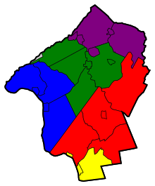
ハンタードン郡の自治体
ハンタードン郡には下記の自治体がある。名称の後の数字は右図の番号である
政治[編集]
ハンタードン郡は共和党の強固な地盤であり、州議会には保守色の強い議員を選出している。共和党のリベラル派に対抗する独立系保守第3政党の候補者を支持することもあり、1997年の州知事選挙では、現職のクリスティーン・トッド・ウィットマン︵共和党︶に対抗する保守系候補2人に13%の支持を与えた。2009年の州知事選挙でも、当選した共和党のクリス・クリスティに対して、共和党予備選挙では保守色の強いスティーブ・ロネガンを4%差で支持した。本選挙でもクリス・クリスティが65%を獲得し、25%だった民主党のジョン・コーザインを破った。 2004年アメリカ合衆国大統領選挙では、共和党のジョージ・W・ブッシュが民主党のジョン・ケリーに対して20.8%差で郡を制したが、州全体ではケリーが6.7%差で勝った[16]。郡政委員も圧倒的に共和党員であり、タウンシップやボロの議員も共和党員が多い。2008年アメリカ合衆国大統領選挙では、共和党のジョン・マケインが民主党のバラク・オバマに対して13.3%差で郡を制したが、州全体ではオバマが15.5%差で勝利した[17]。収入と税[編集]
ハンタードン郡は、2000年の一人当たり年収が 36,370米ドルであり、国に第7位である。世帯当たり収入は最近のデータで99,099米ドルとなり、国内第4位だった。上位にはバージニア州の3郡が来ていた。2005年時点で一人当たり資産税は6,988米ドルとなり、国内第3位、州内第1位だった[18]。税務財団の2006年データに拠れば、資産税の中央値が7,999米ドルとなり、国内第1位だった[19][20]。都市と町[編集]

ボロ[編集]
●ブルームズベリー、15 ●カリフォン、25 ●フレミントン、8 - 郡庁所在地 ●フレンチタウン、12 ●グレンガードナー、22 ●ハンプトン、23 ●ハイブリッジ、21 ●レバノン、20 ●ミルフォード、13 ●ストックトン、5都市[編集]
●ランバートビル、1町[編集]
●クリントン、18タウンシップ[編集]
●アレクサンドリア、11 ●ベスレヘム、16 ●クリントン、19 ●デラウェア、4 ●イーストアムウェル、3 ●フランクリン、10 ●ホランド、14 ●キングウッド、6 ●レバノン、24 ●ラリタン・タウンシップ、7 ●レディントン、9 ●テュークスベリー、26 ●ユニオン、17 ●ウェストアムウェル、2未編入の町[編集]
●アナンデール︵クリントン・タウンシップ︶ ●コークスベリー ●メカニクスビル︵レディントン・タウンシップ︶ ●オールドウィック︵テュークスベリー・タウンシップ︶ ●レディントンビレッジ︵レディントン・タウンシップ︶ ●リンゴーズ︵イーストアムウェル・タウンシップ︶ ●サージェンツビル︵デラウェア・タウンシップ︶ ●スタントン︵レディントン・タウンシップ︶ ●スリーブリッジズ︵レディントン・タウンシップ︶ ●ホワイトハウス︵レディントン・タウンシップ︶ ●ホワイトハウスステーション︵レディントン・タウンシップ︶公園とレクリエーション[編集]
●ポイント山セクション ●マウンテンファーム/ティータータウン保存地 ●タワーヒル公園 ●チャールズタウン保存地 ●ユニオンファーネス自然保存地 ●コロンビア・トレイル・セクション ●コールドブルック保存地 ●マスコニトコング峡谷セクション ●シック保存地 ●ホフマン公園 ●南支流保存地 ●ランズダウン・トレイル・セクション ●カシェタンク山自然保存地 ●ハンタードン郡樹木園 ●ディアパス公園とラウンド山セクション ●アップランズ保存地 ●クローバーヒル公園 ●ヘロングレン・ゴルフコース ●ウェスコット自然保存地 ●サウスカウンティ公園 ●フューチャー公園 ●ラポート保存地 ●サワーランド山自然保存地 ●ジャグタウン山自然保存地観光地[編集]
●ベネデュース・ビニヤーズ ●ハンタードン郡樹木園 ●ハンタードン郡美術館 ●ハンタードン郡庁舎 ●ハンタードン医療センター ●マウントセイラム・ビニヤーズ ●オールドヨーク・セラーズ ●レッドミル、クリントン ●ソリチュード・ダム / TISCO 本部、ハイブリッジ ●ソリチュード家屋博物館、 ハイブリッジ ●テイラー鉄工所員歴史的グリーンウェイ、ハイブリッジ ●ユニオンビル・ビニヤーズ教育[編集]
高校[編集]

高等教育機関[編集]
●ラリタン・バレー・コミュニティカレッジ、2年制コミュニティカレッジであり、ハンタードン郡とサマセット郡の学生を受け入れている。ニュージャージー州の郡カレッジネットワーク19校の1つ。1965年設立、ノースブランチにある[22] ●ラトガース大学がラリタンバレー・コミュニティカレッジと共同で、学位取得プログラムを提供している。ラリタンバレー・コミュニティカレッジのノースブランチ・キャンパスでラトガースの授業に出席することになる[23]。著名な出身者[編集]
●エマ・ベル︵1986年- ︶、女優 ●ジャック・カスト︵1979年- ︶、メジャーリーグベースボール選手 ●トロイ・グロース︵1976年- ︶、メジャーリーグベースボール選手 ●マーヴ・グリフィン︵1925年-2007年︶、音楽家、司会者、プロデューサー ●ジェームズ・マーシャル︵1810年-1885年︶、1848年にカリフォルニア州サッターズミルで金を発見した ●クリスティーン・トッド・ウィットマン︵1946年- ︶、第50代ニュージャージー州知事脚注[編集]
(一)^ “Quickfacts.census.gov”. 2023年8月28日閲覧。
(二)^ American FactFinder - Flemington, New Jersey - accessed 2011-12-06.
(三)^ Hunterdon County, NJ[リンク切れ], National Association of Counties. Accessed January 20, 2013.
(四)^ DP-1 - Profile of General Population and Housing Characteristics: 2010 for Raritan township, Hunterdon County, New Jersey, United States Census Bureau. Accessed July 20, 2012.
(五)^ 250 Highest Per Capita Personal Incomes of the 3113 Counties in the United States, 2009, Bureau of Economic Analysis. Accessed April 9, 2012.
(六)^ abcSnyder, John P. The Story of New Jersey's Civil Boundaries: 1606-1968, Bureau of Geology and Topography; Trenton, New Jersey; 1969. p. 153. Accessed May 30, 2012.
(七)^ Fun Facts, Hunterdon County, New Jersey. Accessed May 30, 2012.
(八)^ Shupe, Lillian. "What's with this? Walpack Township once part of Hunterdon, Hunterdon County Democrat, April 19, 2012. Accessed May 30, 2012. "At one time Hunterdon County, the second county to be established in New Jersey, extended as far south as Trenton and as far north as the New York State line which at that time was about 10 miles north of Port Jervis, N.Y. Hunterdon County was named for Robert Hunter, a colonial governor of New Jersey. His former home in England was called Hunterston but over time the name was changed to Hunterdon."
(九)^ “Census 2010 U.S. Gazetteer Files: Counties”. United States Census. 2013年4月13日閲覧。
(十)^ Hunterdon County Bus / Rail Connections, New Jersey Transit, backed up by the Internet Archive as of July 26, 2010. Accessed September 20, 2012.
(11)^ ab“Monthly Averages for Flemington, New Jersey”. The Weather Channel. 2012年10月13日閲覧。
(12)^ “Geostat Center: Historical Census Browser”. University of Virginia Library. 2009年12月6日時点のオリジナルよりアーカイブ。2007年3月2日閲覧。
(13)^ “The Counties and Most Populous Cities and Townships in 2010 in New Jersey: 2000 and 2010”. United States Census Bureau (2011年2月3日). 2011年2月21日時点のオリジナルよりアーカイブ。2011年2月5日閲覧。
(14)^ DP-1 - Profile of General Demographic Characteristics: 2000; Census 2000 Summary File 1 (SF 1) 100-Percent Data for Hunterdon County, New Jersey, United States Census Bureau. Accessed January 21, 2013.
(15)^ “Hunterdon County, New Jersey – Fact Sheet – American FactFinder”. Factfinder.census.gov. 2010年7月22日閲覧。
(16)^ New Jersey Presidential Election Returns by County 2004 Archived 2008年9月14日, at the Wayback Machine., Eagleton Institute of Politics at Rutgers University. Accessed August 31, 2008.
(17)^ U.S. Election Atlas
(18)^ Property Taxes on Owner Occupied Housing by County, 2005, Tax Foundation. Retrieved October 4, 2006.
(19)^ Woolsey, Matt. "America's Priciest Property Taxes", Forbes, October 3, 2007. Accessed January 11, 2008. "The hardest hit? Homeowners in western New Jersey's Hunterdon County. Last year, the median yearly property tax bill amounted to a whopping $7,999 here, according to the Tax Foundation, a nonpartisan research group in Washington, D.C, which compiled data based on 2006 figures."
(20)^ New York, New Jersey Homeowners Nation's Hardest Hit by Property Taxes, Tax Foundation press release dated September 12, 2007. Retrieved January 11, 2008.
(21)^ Petty, Todd (2012), Bloomsbury school board will consider ending relationship with Phillipsburg High School tomorrow night 2012年11月1日閲覧。
(22)^ History, Mission & Core Values, Raritan Valley Community College. Accessed May 30, 2012.
(23)^ About Raritan Valley, Rutgers University. Accessed May 30, 2012.
外部リンク[編集]
- Hunterdon County Official Website - 公式サイト
- Map of Hunterdon County
- Hunterdon Land Trust Alliance
- HunterdonCountry.com
- River Ballet Company
- OurHunterdon.com
- Hunterdon County Obituary Collection
- Hunterdon County Chamber of Commerce Website
- NY-NJTC: Teetertown Ravine Nature Preserve Trail Details and Info
- Hunterdon County Library
