
アメリカ国道

アメリカ国道︵アメリカこくどう︶とは、アメリカ合衆国を走る一般道路および自動車専用道路のうち、特に米国全土を座標に見立て、番号を付けた幹線道路の総称。正式名称は United States numbered highways︵アメリカ合衆国番号つき公道︶で、一般に U.S. Routes や U.S. Highways と呼ばれる。以下特に混乱の恐れのない限り単に﹁国道﹂と呼ぶ。
米国には長距離走行用の道路網として国道の他に州間高速道路と呼ばれる道路網も存在する。後者は全区間が自動車専用の高規格道路であるのに対し、国道の方は大部分が一般道である。州間高速道路と国道との関係は日本の高速道路と国道の関係と比較すると分かりやすい︵但し州間高速道路に有料区間はほとんどない︶。
各州の間で調整が行われるので﹁連邦高速道路、Federal Highways﹂と呼ばれることもあるが、1926年の開通以来一貫して州政府及び沿線の地方自治体が維持・管理を行っており、連邦政府が関わった事はない。道路番号と路線の選定は米国全州道路交通運輸行政官協会︵American Association of State Highway and Transportation Officials、以下AASHTO︶が一元的に行っており、連邦政府の関与はAASHTOにオブザーバーとして米国運輸省が参加するのみである。
南北方向に走る道路には東から西へ順に奇数の、東西方向に走る道路には北から南へ偶数の道路番号が付けられている。南北方向の道路の内、主要なものは下一桁が1番、同じく東西方向の主要道は下一桁が0番で終わっている。三桁国道は対応する二桁国道の支線︵例えば321号線は21号線の支線︶にあたるが、両者は必ずしも接続しているわけではなく、本線と支線が一度も分岐・合流することなく独立した路線を成していることもある。一部の路線では一つの路線番号に対して二つの異なる道路が割り当てられていることがある。こうした路線重複は大半が廃止されているが、一部には Alternate route︵別線︶ないし Bypass route︵バイパス線︶として現役のままの道路も有る︵後述︶。
国道の担ってきた地域間輸送の役割は後発の州間高速道路に取って代わられたが、地域内輸送は未だに国道に深く依存しており、今日でも路線網の拡張は続けられている。
国道網の整備以前はカナダにまで及ぶ自動車専用道︵Auto trail︶がその役割を果たしてきた。米国全州道路交通運輸行政官協会︵American Association of State Highway and Transportation Officials、以下AASHO︶の諮問機関﹁州間高速道路合同委員会、Joint Board on Interstate Highways﹂は全米レベルで主要道に番号を付けることにした。幾度か会合を経て1925年11月に最終報告書を米国農務省に提出し、承認された。その後各地方から路線選定に関する意見をまとめ、最終報告書に修正を加え、最終的には全米国道網︵The United States Numbered Highway System︶として1926年11月に認可された。認可を得るために、一つの番号に別線を設け、異なる地域を経由できるよう譲歩した路線が多かったが、混乱を招くとして、認可後の数年間、ASSHTOでは別線の廃止を目標に掲げた。その後国道網は拡張を重ねたが、1956年の州間高速道路の着工を機に、大部分が州間高速道路に昇格した。
道路網の詳細[編集]
現行の道路標は黒地の正方形。 カリフォルニア州でのみ旧式の道路標が今なお使われている。
後発の州間高速道路とは異なり、特に道路規格は設けられていない。高速道路規格で敷設した部分もあるが、一般に沿線の市街地では、その街の目抜き通りとなっている場合が多い。ただし、今後新たに着工する部分についてはAASHTOの定める道路規格にほぼ準ずる事とされている。[1]
有料橋、有料トンネルはあるが、道路自体が有料になっている区間はほとんどない。AASHTOの勧告により有料道路でも特別路線︵後述︶としてであれば国道網に組み込むことができる。ただしその際にも﹁有料道路区間の起点と終点を結ぶ既存の国道は、有料道路の開通後も、国道としての指定を解除しないこと﹂としている。[1] 国道3号線は有料道路 Everett Turnpike と路線を共有しているが、共有部分の Everett Turnpike は無料区間なので当基準を満たしている。ただし基準を満たさないケースも多く、上記基準を満たしているのは下記4区間のみ。[2]
●51号線はイリノイ州内の一部区間で有料道路のJane Addams Memorial Tollwayと路線を共有する。旧51号線はイリノイ州道251号線として供用中︵州道だが国道の別線扱い︶。
●278号線はサウス・キャロライナ州内の一部区間で有料道路のCross Island Parkwayと路線を共有する。旧道は278号通勤別線︵U.S. Route 278 Business︶として供用中。
●412号線はオクラホマ州内の一部区間で有料道路のCimarron Turnpike と路線を共有する。旧道は64号線として供用中。
●412号線は更に先でもCherokee Turnpikeと路線を共有する。旧道は412号観光別線︵U.S. Route 412 Scenic︶として供用中。
番号の振り方[編集]
先述のように道路番号が奇数の路線は南北方向、偶数の路線は東西方向に走る。そのうち101号線は十の位が﹁10﹂の二桁国道とみなされる。番号は東の1号線から西の101号線、南の2号線から北の98号線へと昇順に振られている。下一桁が0番か1番︵および、国道2号線[3]︶の国道は主要道、5番の国道は準主要道とされてきたが、道路網の拡張と短縮を繰り返した結果、今日この区別はあまり厳密に守られてはいない。例として、国道6号線は番号上は主要道ではないにもかかわらず、1964年まで最長の国道であった︵現在の最長は20号線︶。州間高速道路の方は国道とは逆に番号を昇順に振っており、同じ地区に同じ番号の国道と州間高速道路が重なってしまわないよう調整されている。[4] 三桁の国道は二桁の国道に付属する別線である。例えば201号線は1号線とメーン州ブランズウィックで分岐、北進しカナダまで伸びる別線。別線が本線とは別方向に進むこともあり、分岐した後再び本線に合流しないものや、そもそも本線と一度も連絡しないようなものもある。百の位の数字は、本線の番号の振り方と同じで、北から南に、東から西に進むほど大きくなる。この点は州間高速道路とは異なる︵州間高速道路の三桁番号は経度緯度にかかわらず、同一の地域内で環状路線は百の位が2, 4, 6, ...の順、放射路線は1, 3, 5, ...の順に振られる。このため別の州にある異なる道路に同じ道路番号がつくこともある︶。60号線を例にとると、ミズーリ州で160号線、西へ下ったオクラホマ州で260号線、更に西進してテキサス州で360号線、ニュー・メキシコ州で460号線、560号線をそれぞれ分岐する。[5] ただ、本線の番号と同じで、再三路線の新設・廃止及び拡張・縮小を繰り返してきたため、本線と支線の関係が崩れてしまったところもある。例えば既に66号線は既に廃止されてしまったが支線︵X66号線︶の方は未だに残っている箇所が多い。また191号線はメキシコ国境からカナダ国境までを縦断するが、本線に当たる91号線の方は、ほとんどの区間が州間高速道路15号線に昇格したので、既に縦断路線ではなくなっている。[6] 1980年以降に認可された別線には番号の振り方の原則に従わないものがある。 ●1994年認可の400号線は本線に当たる0号線、100号線が存在しない。[7] ●1982年頃に認可された412号線は12号線とは全く別の場所を走る。[7] ●1989年認可の425号線は25号線とは全く別の場所を走る。[7] 加えて、1970年に番号が与えられた163号線は63号線とは全く別の場所を走る。[8] 1970年ごろ認可された57号線はメキシコの国道57号線と連絡する路線で、以前の米国国道81号よりも西を走っている。[7] ASSHTOの勧告で州間高速道路と国道の道路番号が同一州内で重複しないように調整されている。[9] 州間高速道路の50号と60号が欠番になっているのはこのためである。ただ1958年の州間高速道路の原案では、イリノイ州に州間高速道路24号線と国道24号線同士、カリフォルニア州で40号線、80号線同士が重複していた。その後カリフォルニア州では番号の再編が行われ、国道40号線、80号線が廃止されたため、現在重複は解消されている。[6] 近年開通した路線や計画中の路線にはこの原則に従わないものもある。国道番号の振り方の原則に従っていない道路があるのも一因。ウィスコンシン州の41号線[10]、アーカンソー州の49号線[11]、テキサス州の69号線[12]、ノース・カロライナ州の74号線[13] が該当。 39、47、86、88番はこれまで使われたことがない。交通省でも理由は分からないとのこと。[要出典] Atentamente: Eduardo Torres, Zacapu Michoacan Mexico併走区間・特別路線[編集]
詳細は「:en:List of divided U.S. Routes」を参照
1926年の供用開始当初から一部路線には併走区間︵divided routes︶が設けられていた。11号線が11号東線、11号西線に分かれるケースなど、東西︵ないし南北︶とも、ほぼ対等な規格の道路であることが多い。11号東西両線はテネシー州ノックスヴィルで分岐してバージニア州ブリストルで再合流する。併走区間の片方にだけ文字が添えられることもある。例えばペンシルベニア州で分岐する6号北線に対して6号南線は存在しない。6号線と6号北線はそれぞれ別の方向に進み、再合流することはない。AASHTOでは1934年以来併走区間の廃止に努めてきた。[14] 現在、新規の併走区間は認可されておらず、現存のものについても﹁各州の交通局と下院道路委員会の合意が得られ次第﹂解消することとしている。[1]
別線︵alternate︶やバイパス線︵bypass︶等の特別路線もAASHTOが管理しており[15]、道路番号の脇に文字を添えて区別することがある。別線であればA、通勤別線︵business︶であればB等。[16]
呼称[編集]
国道網の呼び方一貫しておらず、機関によって︵あるいは同一機関内でも︶異なる呼び方をする。公式の路線一覧はAASHTOが1989年まで発行していたが、一覧中では初版の1926年以来一貫して国道はUnited States Numbered Highwaysと呼ばれている。しかし一覧の目次ではU.S. Route、各路線の見出しにはUnited States Highwayがそれぞれ使われている。国道の道路番号制定特別委員会では少なくとも1989年以降U.S Routeの呼称を、連邦法でもUnited States RouteないしU.S. Routeの方を使うことが多くU.S. HighwayやUnited States Highwayの使用頻度は低い。[17] 各地域レベルでの呼び方は州毎にまちまちで、デラウェア州のようにrouteを使う州もあればコロラド州のようにhighwayの方を使うところもある。[18][19]歩み[編集]
初期のauto trails[編集]
詳細は「:en:Auto trail」を参照
1910年代初頭にリンカーン・ハイウェイをはじめとする長距離用の道路の建設が始まった。大抵の土木業者は沿線の自治体や州と共同して道路の整備にあたったが、中には資金提供をしてくれる町にだけ道路を通し、標識だけ立てて他は何もしないような事業者もあった。[20]

初期の道路標識。1926年から1940年代後半まで使われた。
二回目の全体会合は1925年8月3、4日に開かれた。道路網の密度が議題に上がり、マサチューセッツ州のWilliam F. Williamsやニューヨーク州のFrederick S. Greenのように大陸を横断する主要道のみを国道に指定する案を支持する向きもあったが、そういった最重要路線に限らず、地域内のみで完結する主要道も国道に指定する案を支持する州が多かった。Greeneは例えばニューヨーク州内の国道を主要4路線に絞る例を挙げている。大方国道のカバーする範囲については意見の一致が見られたが、中西部の道路が多すぎるとする意見が多かった。第一回の会合で採択された道路標識は若干の修正の後採択され、道路に固有名ではなく数字を振る案も可決された。東西方向の主要8路線、南北方向の主要10路線の番号の振り方については、番号制定小委員会に無条件で付託された。[20]
各州との協議を経て合意に至った最終案では総延長122,000キロ︵75,800マイル︶、国内全線の2.6%にも及ぶ計画となり、8月4日に可決した草案より50%以上も路線長が伸びている。番号の振り方は連邦道路局のEdwin Warley Jamesが8月27日に骨子をまとめ、方向により偶奇を振り分け、全米を座標に見立てて順に番号を振る案を提示した。当初の計画図では下一桁が0、1、5で終わるものを主要道︵その後間もなく下一桁が5の路線は準主要道に格下げられている︶、短距離連絡路線については接続先の本線に応じた三桁の道路番号が与えられた。会員5名からなる小委員会で9月25日に最終案がまとめられ、州間高速道路合同委員会に10月26日付けで最終報告書が提出された[20]。10月30日には農務長官の下に報告書が送られ、1925年11月18日に認可された。
当時の主な大陸横断路線︵一部は既存のauto trailをざっくりと踏襲した路線︶は以下の通り。
第一次試案: 1925年調査報告書作成まで[編集]
ウィスコンシン州が全米に先駆けて道路に番号を振り始め、1918年5月に道路番号標識を整備した[20]。他の州もすぐにウィスコンシン州に続き、1922年にはニュー・イングランド地方の6州が共同でニュー・イングランド州間道路︵New England Interstate Route︶を立ち上げた[21]。 そんな中連邦政府でも連邦道路整備補助案Federal Aid Highway Act of 1916の通過を機に主要道の整備費用の半額を負担することとした。 続く1921年度版の連邦道路整備補助案Federal Aid Highway Act of 1921では補助対象の道路を各州の道路の7%までとし、うち七分の三は州を横断する道路とされた。 路線の選定は1923年までに完了している。[20] 全米州高速道路協会︵American Association of State Highway Officials、略称‥AASHO︶が1914年に結成され、道路規格の策定を行った。1924年の会合で主要道路に番号を振り、標識を整備した﹁州を横断する高速道路、interstate highways﹂を計画した。AASHOでは農務長官が各州と共同し路線の策定にあたるべきとの答申を出した[20]。 農務長官の Howard M. Gore は答申を受け、州間高速道路合同委員会 the Joint Board on Interstate Highways を1925年3月2日に結成した。構成員は州の高速道路管理官が21人、連邦道路局︵Bureau of Public Roads︶付けの係官が3人。4月20、21日の初会合で U.S. Highway という名称が採択された。また米国国章に模した道路標識も決まった[20]。 これに Auto trail 側は即座に反発した。既存の高速道路名を廃止し番号に置き換えることに反発したもので、これを受けて委員会側では地域レベルの会合を開き懐柔に努めた。5月15日に西部、同27日にミシシッピ川流域、翌月3日に五大湖地域、8日に南部、15日に北大西洋地方およびニュー・イングランド地方で会合が持たれた。Auto trail側は会合で発言することはできなかったが、各地を訪れていた委員と直接交渉し、委員会ではauto trail側の案と大筋で合意するに至った。暫定案では総延長81,000マイル︵130,000キロ︶に及び当時の公道の2.8%を占めることとなった。[20]
10、60、90号線は厳密には大陸横断路線にはなっておらず、実際には大陸を三分の二程横断したところで途切れている。また11号線は南北方向ではなく、南西から北東方向へ、60号線は東西方向ではなくやはり南西から北東方向へ走っている。60号線が原則から大きく外れてしまっているあたりに︵下一桁が0の幹線道路用の番号にもかかわらず大陸を横断しきっていない点、偶数番号にもかかわらず東西方向に伸びていない点︶、計画策定時の紆余曲折ぶりが見て取れよう。ちなみに60号線はその後1926年にかのルート66︵66号線︶に差し替えられている。また101号線は奇数番号の南北路線にもかかわらずワシントン州で東に折れ、更に南下してワシントン州都オリンピアまで伸びている。[22] 当時の2号線は大陸を横断しきっていなかったが、現在は上記のBonners Ferryから更に西のワシントン州Everettまで延長されており、道路番号の原則通り大陸横断路となっている。

1926年11月11日に可決された決定稿
発足以降各地で賛否両論が起きたが、概ね幹線道路の沿線自治体では賛成、路線から外れてしまった地域では反対意見が多かった。Auto trailの草分け、リンカーン・ハイウェイ協会では、保有路線を可能な限り国道30号線として指定してもらったこともあり、国道建設計画を支持した。ただ他のauto trailの運営者はこれまで自社路線が担ってきた役割を新設の国道に代替されてしまうことを恐れ反対した。1926年1月14日から15日にかけて行われた公聴会でAASHOに非難が殺到した[20]。
ノースイースト地方では、ニューヨーク州が従来通り路線の削減を求めたのに対し、南隣のペンシルベニア州は︵ちなみに当州は前述の地域会合には参加していない︶AASHOに、より緻密な路線網の策定を求めた。結果的に6路線がニューヨークとペンシルベニアの州境で途切れることになってしまった︵その後路線のニューヨーク州内への延長が行われた。現在も州境で途切れたままになっているのは220号線のみで、ペンシルベニアからニューヨークに渡ってすぐのニューヨーク州道17号線︵近く州間高速道路86号線に昇格予定︶との交差点付近で途切れている︶。また20号線がイエローストーン国立公園で途切れてしまっていることからアイダホ、オレゴン両州が国立公園から先西海岸までの区間を30号線と入れ替えるよう求めた[20]。
主に各地で議論になったのは、ほぼ同規模の道路が併走している場合にどちらを国道に指定するかという問題だった。特にかつてのauto trail同士の競合区間でこうした問題が顕著だった。1月の会合でAASHOは初めて2路線︵40号線キャンザス州マンハッタン-コロラド州リモン間、及び50号線キャンザス州ボールドウィン-同ガーデン・シティー間︶に併走区間を認めた。これを発端に、後大量の併走区間を生み出してしまうことになる。公式の路線一覧ではUS 40 North, US 40 Southのように記録されているが、案内上はUS 40NやUS 40Sのように略記されている[20]。
各地域レベルでの論争もさることながら、一番の争点となったのは60号線の扱いだった。合同委員会の方では当初60号線をロサンゼルス-シカゴ間の道路とする予定で、ロサンゼルスを出た後、オクラホマ州都オクラホマ・シティーまで東進し、その後北東方向に大きく向きを変え、終点シカゴへ向かう予定であった。また原案ではイリノイ州内を東西方向ではなく南北方向に進むようになっていた。この案にケンタッキー州は猛反発した。当州は幹線級の東西方向の路線が通らず、62号線が通るだけの計画になっていた。そこで、原案の60号線沿線各州の了承を得られ次第、原案の62号線と52号線のケンタッキー州アッシュランド以東の区間が新60号線とされ、62番は旧60号線ロサンゼルス-シカゴ間の新番号とすることが決められた。ところが原案で60号線が通ることになっていたミズーリ、オクラホマ両州は調整案に反対した。ミズーリ州では既に地図を刷ってしまっており、オクラホマ州では既に道路標識を準備してしまっていた。譲歩案として、60号線をミズーリ州スプリングフィールドで分岐して60号東線、60号北線とする案が出されたが、3州とも反対している。結局、62号線を66号線とすることで決着した。主要幹線用の番号ではないものの、きりのいい番号と言うことでケンタッキー州の了承を取り付けた[20]。
既に32州が路線の整備に取り掛かる中、1926年11月11日にAASHOは最終計画を了承した[20]。最終案には、譲歩の末、併走区間のある路線や途中区間がつながっていない路線︵6、19、50号線等︶、州の境でぷっつりと途切れてしまっている路線(先述)などが含まれていた[23]。ペンシルベニア州では初版の路線一覧表が出版される際に、既存のauto trailに番号を割り振るために道路番号の大幅な再調整が行われた[24]。また15号線はバージニア州まで延長された[25]。
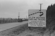
1941年に撮影されたワシントン州シアトルとオレゴン州ポートラン ドを結ぶ国道上の標識。﹁国防上重要な道路です。足の遅い車やトラックは不必要に交通を妨げることのないよう。﹂と書かれている。国道網の整備理由の一つに国家防衛があったことを示す一例。
1934年にAASHOは併走区間を公式の路線一覧から外し、併走路線の片方を三桁国道か別線に格下げするか、新たに二桁の番号を与える︵31号東線の一部を37号線に置き換え︶ことにした。AASHOはAmerican Highways1934年10月号で番号の再整理に関する指針を以下の通り明らかにしている[26]。
1925年の国道網の発足当初に僅かながら併走区間が認められ、東西南北いずれかの文字を番号に添えて区別した。今日でも数路線でこうした併走区間があるものの、沿線の合意が得られ次第、併走区間の片方をもう一方の路線に吸収する形で解消していくのが望ましい。
併走区間が短く、新たに番号を振るほどでもない場合には、開通したのが早い方ないし短い方の路線を本線扱いにして東西南北の添え字を外し、併走する路線に関しても標準形の道路標識に﹁別線︵Alternate︶﹂と表示した上で東西南北の添え字を外すこととされた。
勧告通り標識を書き換える州もあったが、カリフォルニア、ミシシッピ、ネブラスカ、オレゴン、テネシーの各州は勧告に従っていない。1952年AASHOは併走区間の完全解消を諦め、11、19、25、31、45、49、73、99号線の併走区間については現状維持とすることを確認した[26][27]。
その後も着々と路線の拡張︵時に路線の廃止が行われることもあった︶が続けられた。面白いものにはAlaska Highwayに沿って97号線をアラスカまで伸延させる計画があったが、ユーコン準州が州内通過区間に97番を振らないことにしたため、実現せずに終わった[28]。
国道網は都市間輸送の主翼を担ってきたが、Pennsylvania Turnpike等の有料道路やMerritt Parkway等の公園道路も国道網を補完してきた。また高速走行用の自動車道が整備された当初も、国道として整備されることが多かった。例えば州間高速道路45号線は元々国道75号線として整備されたものである[29]。またPasadena Freewayは当初国道66号線[30]、Pulaski Skywayは国道1号線と9号線であった[31]。
AASHOと沿線各州による再調整︵1925年から1926年まで︶[編集]

マスコミの反応[編集]
計画が発表された当初は、従来の路線名を廃止し路線番号に置き換えることに批判の矛先が向かった。路線番号はauto trail網で使われていた個性的な路線名に比べて冷たく、無機質だと感じる向きもあった。ニューヨークタイムスは﹁﹃リンカーン・ハイウェイ﹄と聞けば涙も出るし、﹃ジェファソン・ハイウェイ﹄と聞けば夢もわくものだ。それが46号線だの55号線だのに心を動かされることはまずない。﹂としている[4]。作家のErnest McGaffeyは﹁偉人の名前︵legend︶が対数︵logarithms︶に取って代わり、歴史︵history︶がうわべだけのつまらないもの︵hokum︶に置き換えられてしまった。﹂[20] と言ったと伝えられている。州間高速道路網発足以前︵1926年から1950年代後期まで︶[編集]

州間高速道路開通後[編集]
1956年度版の連邦道路整備補助案で州間高速道路の整備が決まり、翌年、AASHTOでは州間高速道路に国道と逆順に番号を振ることにした。州間高速道路は国道を補完する道路網として企図されたが、実際には、特に西部で国道をそのまま州間高速道路に置き換えることが多かった[6]。1964年のカリフォルニア州で行われた道路番号整理を機に大規模な国道の指定廃止が始まった。1985年の66号線の廃止は国道時代の終焉を象徴する出来事だったとされる[32]。 最後の主要国道の開設はアイダホ州Lolo Passの12号線の開通で、1962年のことだった。最後まで残った未舗装区間は183号線のRose地方とネブラスカ州タイラーの区間で、1967年頃に舗装された[33]。 かつては整備状況の良い道路の鏡とされていた国道網であるが、ASSHTOではかつての国道の役割は州道に取って代わられたとの見方をとっており、480キロ︵300マイル︶未満の国道については、﹁沿線の州交通局とAASHTOとの間で合意が得られ次第﹂国道指定を解除していくこととしている。現在、新規に国道の指定を受ける場合には、当該路線が複数の州に跨りかつ﹁大方AASHTOの道路規格に適合すること﹂が必要[1]。参照[編集]
- List of roads and highways
- National Highway System (United States)
- United States Numbered Bicycle Routes
参考文献[編集]
(一)^ abcdEstablishment and Development of United States Numbered Highways (PDF, 15.6 KB) , revised October 6, 1996
(二)^ “Toll U.S. Highways”. Us-highways.com. 2010年4月11日閲覧。
(三)^ “Ask the Rambler: What Is The Longest Road in the United States?”. Fhwa.dot.gov. 2010年4月11日閲覧。
(四)^ abMcNichol, Dan. The Roads that Built America: The Incredible Story of the U.S. Interstate System. New York: Sterling Publishing Co., Inc., 2006. ISBN 1-4027-3468-9
(五)^ 1925 map of U.S. Highway System (Map).
{{cite map}}: |access-date=を指定する場合、|url=も指定してください。 (説明) File:1925us.jpg
(六)^ abcUnited States Featuring The Interstate Highway System (Map). Cartography by General Drafting. Esso. 1966.
(七)^ abcdDroz, Robert V. U.S. Highways : From US 1 to (US 830). URL accessed 02:55, 4 July 2006 (UTC).
(八)^ “Arizona DOT Right-of-Way Resolutions”. Arizona Department of Transportation. 2008年3月30日閲覧。
(九)^ Establishment of a Marking System of the Routes Comprising the National System of Interstate and Defense Highways (PDF, 7.88 KB) (Retained from August 10, 1973)
(十)^ Jones, Ben (2006年12月18日). “'Interstate 41' on near horizon”. The Post Crescent
(11)^ “Ross (AR04) Newsletter ? Interstate 49”. Congressman Mike Ross (2001年6月8日). 2009年6月7日閲覧。
(12)^ Texas Department of Transportation, I-69/TTC (Northeast Texas to Mexico). Retrieved August 2007.
(13)^ Woodard, Johnny (2008年10月8日). “I-74 four-lane to Lumberton opened” (PDF). The Laurinburg Exchange. 2009年6月7日閲覧。
(14)^ Richard F. Weingroff, U.S. 11 Rouses Point, New York, to New Orleans, Louisiana
(15)^ AASHTO (2000年1月). “Establishment and Development of United States Numbered Highways” (PDF). 2008年1月23日閲覧。
(16)^ “Bannered U.S. Highways”. Us-highways.com. 2010年4月11日閲覧。
(17)^ Google searches on thomas.loc.gov for "United States Route", "U.S. Route", "United States Highway" and "U.S. Highway"
(18)^ http://www.deldot.gov/information/pubs_forms/manuals/traffic_counts/2006/pdf/rpt_pgs1_38_rev.pdf DelDOT 2006 Traffic Count and Mileage Report
(19)^ Segment Descriptions for Highway 006 Colorado Department of Transportation
(20)^ abcdefghijklmnRichard F. Weingroff, From Names to Numbers: The Origins of the U.S. Numbered Highway System
(21)^ Motor Sign Uniformity, New York Times, April 16, 1922
(22)^ United States System of Highways (Map). Bureau of Public Roads. 1926. 
{{cite map}}: |access-date=を指定する場合、|url=も指定してください。 (説明) File:United States System of Highways Adopted for Uniform Marking by the American Association of State Highway Officials.jpg
(23)^ United States System of Highways, November 11, 1926
(24)^ “U.S. 22: The William Penn Highway”. Fhwa.dot.gov. 2010年4月11日閲覧。
(25)^ United States Numbered Highways, American Highways (AASHO), April 1927
(26)^ ab“U.S. 11 - Rouses Point, New York, to New Orleans, Louisiana”. Fhwa.dot.gov. 2010年4月11日閲覧。
(27)^ “Divided (Split) Routes”. U.S. Highways. 2010年4月11日閲覧。
(28)^ Robert V. Droz. “Alaska's U.S. Highway(s)”. Us-highways.com. 2010年4月11日閲覧。
(29)^ Feldstein, Dan (1999年6月27日). “A rare quiet interlude for area's first freeway Next major upgrade: Causeway in 2002”. Houston Chronicle. 2009年6月9日閲覧。
(30)^ Correspondence between the Division of Highways and American Association of State Highway Officials, transcribed at California Highways: State Route 66
(31)^ Rand McNally Road Atlas, 1946, p. 42: New York and Vicinity
(32)^ California Highways and Public Works, March-April 1964, Route Renumbering (PDF)
(33)^ Robert V. Droz (1926年11月11日). “north?south routes”. U.S. Highways. 2010年4月11日閲覧。
外部リンク[編集]
- AASHTO Special Committee on U.S. Route Numbering
- U.S. Numbered Highways - 1989 Edition (AASHTO)
- Highway History - Other Articles (Federal Highway Administration)
- U.S. Highways: From US 1 to (US 830)
- US Highway Ends: maps and terminus photos
| 1 | 2 | 3 | 4 | 5 | 6 | 7 | 8 | 9 | 10 | 11 | 12 | 13 | 14 | 15 | 16 | 17 | 18 | 19 | |
| 20 | 21 | 22 | 23 | 24 | 25 | 26 | 27 | 28 | 29 | 30 | 31 | 32 | 33 | 34 | 35 | 36 | 37 | 38 | |
| 40 | 41 | 42 | 43 | 44 | 45 | 46 | 48 | 49 | 50 | 51 | 52 | 53 | 54 | 55 | 56 | 57 | 58 | 59 | |
| 60 | 61 | 62 | 63 | 64 | 65 | 66 | 67 | 68 | 69 | 70 | 71 | 72 | 73 | 74 | 75 | 76 | 77 | 78 | 79 |
| 80 | 81 | 82 | 83 | 84 | 85 | 87 | 89 | 90 | 91 | 92 | 93 | 94 | 95 | 96 | 97 | 98 | 99 | ||
| 101 | 156 | 163 | 266 | 400 | 412 | 425 | |||||||||||||
| 一覧 | アメリカ国道 | ||||||||||||||||||