
レーニア山国立公園
| レーニア山国立公園 | |
|---|---|
 | |
| 地域 |
アメリカ合衆国ワシントン州 ピアース郡およびルイス郡 |
| 最寄り | タコマ |
| 座標 | 北緯46度51分 西経121度45分 / 北緯46.850度 西経121.750度座標: 北緯46度51分 西経121度45分 / 北緯46.850度 西経121.750度 |
| 面積 |
953.5 km² (235,625 エーカー) |
| 創立日 | 1899年3月2日 |
| 訪問者数 | 1,113,601人(2006年) |
| 運営組織 | アメリカ合衆国国立公園局 |
レーニア山国立公園︵レーニアさんこくりつこうえん、またはマウントレーニア国立公園︵マウントレーニアこくりつこうえん︶、英: Mount Rainier National Park︶はアメリカ合衆国ワシントン州ピアース郡の南東部からルイス郡の北東部にかけて位置する国立公園である[1]。1899年3月2日に合衆国5番目の国立公園として設立された。公園は953 km2︵368平方マイル︶の面積であり、標高4,392m︵14,410フィート︶の成層火山であるレーニア山全体が含まれている[2]。カスケード山脈の中の最高峰であるレーニア山の周囲には谷や滝、亜高山帯の野生植物の草原、原生林と26以上の氷河がある。この火山はしばしば雲に覆われ、毎年山頂部は大量の降雨、降雪にみまわれる。
レーニア山には山の周りを一周するワンダーランドトレイル(en)と呼ばれるトレイル︵登山道︶があり、合計91km2︵35平方マイル︶の面積があるいくつかの氷河と雪原に覆われている。そのうち、エモンズ氷河(en)が面積で米国本土最大である一方、カーボン氷河(en)が体積で最大であり、かつ最も低い標高︵1,067 m︵3,500 フィート︶︶に舌端がある。北緯46度の中緯度で、なおかつ標高の低い地点にこれだけ大規模な氷河が存在するのは、太平洋からやってくる湿気を帯びた風がレーニア山にぶつかり、それにより冬期に大量の降雪をもたらすためである
[3]。
毎年およそ130万人がこの国立公園を訪れる。約1万人がレーニア山への登頂を目指し、そのうちおよそ25パーセントだけが登頂に成功する。
この公園には類い希なる実例となる原生林と亜高山帯の草原が含まれている。
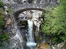
クリスティン滝。表通りから歩いてすぐのところに見える、多くの滝の 内の一つ。

ハイカーズセンター︵1911年築︶
現在は土産物店と雑貨店である
ロングマイヤー(Longmire、位置:北緯46度45分 西経121度49分 / 北緯46.75度 西経121.81度) はレーニア山国立公園のビジターセンターがある地点、ニスカリーエントランスの東10.5km︵6.5マイル︶である。この地域は標高842 m(2,761フィート)[17] のニスカリー川(en)流域であり、ラムパーツ尾根とタトゥーシュ山脈の間に位置する。ロングマイヤーはベイマツ、ベイスギ、ベイツガの原生林に囲まれている。ロングマイヤーには他に宿泊所であるナショナルパークイン、ロングマイヤー博物館、土産物店、そして今は原生地域インフォメーションセンターとして機能している国立公園局の管理棟がある。ナショナルパークインはこの公園内では唯一、年間を通して営業している宿泊施設である[18]。
﹁ロングマイヤー﹂の名は1883年にこの地にトレイルを作ったジェームズ・ロングマイヤー(James Longmire)の名にちなむ[19][20]。
ロングマイヤーは公園の訪問客にとってパラダイスに次いで人気のある目的地である。2000年には130万人以上がこの公園を訪れたが、そのうち38パーセントがロングマイヤーに行った[10]。ロングマイヤーの3km(2マイル)北西にはクーガーロックキャンプ場がある[1]。ロングマイヤーはワンダーランドトレイルの出発地点の一つである。

サンライズにおける亜高山帯草原
サンライズ(Sunrise、位置:北緯46度54分36秒 西経121度38分24秒 / 北緯46.91000度 西経121.64000度)はロッジとビジターセンターがある地点でレーニア山国立公園の北東部、ピアース郡内に位置する。高さは1,950m(6,400フィート)で、それは車両でアクセス可能な公園内での最高地点である。サンライズの周りにはフリーモント山(en)やサワードウ尾根(en)などに、沢山のトレイルがある。ロッジにはホワイトリバー(en)エントランスの近くでワシントン州道410号から16km︵10マイル︶脇道に入ったところにある。
歴史[編集]
公園の97パーセントが原生自然保全制度(en)によって原生地域として保護されており、そこには1988年に指定された、クリアウォーター原生地域(en)も含む。公園外のタトゥーシュ原生地域(en)がそこに隣接している。公園からは1997年2月18日に、1920年代と1930年代のパーキテクチャー︵﹁公園の中の建造物﹂という意味の造語︶として、パラダイスイン(en)という宿初施設並びに初期のアメリカ合衆国国立公園局の基本計画の傑作に相当する物件がアメリカ合衆国国定歴史建造物に指定された。歴史的建造物地区として、公園は、国立史跡登録(en)に行政的な登録がなされた[4]。アメリカ先住民[編集]
現在レーニア山国立公園である地域での、人類の活動で最も初期の証は、ベンチレイクトレイル︵スノーレイクトレイルの最初の部分︶沿いで見つかったおよそ4,000-5,800年BC[5]の有舌尖頭器である [6][7]。 より重要な考古学上の発見は、ゴートアイランド山の東、フライングパンクリークのそばで岩窟住居跡が発見されたことである。狩猟用の加工品が岩窟内で発見された。しかしどうやら岩窟住居は一年を通して使用されたわけではないようである。文化的な類似性から、この場所が300-1,000年BPに、コロンビア高原の部族によって利用されたことが示唆される[6][7]。 1963年に国立公園局はアメリカ先住民︵インディアン︶によるレーニア山地域の利用について研究するため、ワシントン州立大学と契約した。リチャード・D・ドアーティーはこの地域の考古学的な研究を指揮して、有史以前の人類がこの地域を最も利用したのは4,500-8,000年BPであると結論づけた。アラン・H・スミスは初老のアメリカ先住民との対談を通して民族誌的な文献の研究を行った。公園地域は、狩猟と採集と、そして時折の精神探索︵アメリカ先住民の通過儀礼(en)︶に使われた。スミスは公園が川の流域界に沿って5つの部族に分けられているという仮の結論に至った。それは即ちNisqually、Puyallup、Muckleshoot、Yakama、Taidnapamの各部族である。その後の研究は彼らが1854年-1855年に合衆国で条約を結ぶ前に、部族間で互いの境界について合意していたとするスミスの理論に疑問を投げかけた[6]。主要な見どころ[編集]

パラダイス[編集]
パラダイス (Paradise、位置:北緯46度47分24秒 西経121度44分24秒 / 北緯46.79000度 西経121.74000度[8])はレーニア山の南斜面上の高度およそ1,600m︵5,400フィート︶の地域の名前である。パラダイスはレーニア山国立公園への訪問客にとって最も人気のあるエリアである。2000年には公園を訪問した130万人のうち62%がパラダイスへと向かった。[9][10] ﹁パラダイス﹂という名は1885年夏にヴィリンダ・ロングマイヤー(Virinda Longmire)によってこの地に映える野生の草花を見て名付けられた [11][9]。パラダイスには、歴史的建造物であるパラダイスイン(en)︵1916年建築︶、[12] パラダイスガイドハウス(en)︵1920年建築︶、空飛ぶ円盤のような形をしたヘンリー・M・ジャクソンビジターセンター(en)︵1966年建築︶がある[13]。 国立公園局は﹁パラダイスは降雪量が定期的に計測される地球で最も雪の多い場所﹂であると言う[14]。1971年-1972年の冬のシーズンには28.5m︵1,112インチ、93.5フィート︶の積雪があり、それはその年の世界最高記録となった。[14][15]。 1956年3月10日時点の932cm︵367インチ︶の降雪がカスケード山脈としての最高記録である[16]ロングマイヤー[編集]

サンライズ[編集]

2006年11月の洪水[編集]
マウントレーニア国立公園は2006年11月6日に発生したパイナップルエクスプレス[21]と呼ばれる暴風雨により降雨量が36時間の間に460mm︵18インチ︶にまで達し、広範囲が洪水となったため閉鎖された。またこれによりキャンプ場と道は流された。パラダイスとロングマイヤーは寸断された。しかし2007年5月5日に、公園はニスカリーエントランスから州道706号線経由で自動車の交通が再開した [22] [23]。脚注[編集]
(一)^ abMt. Rainier National Park (Map) (Centennial ed.). 1 : 30,000. Cartography by Charles B. Kitterman / Kulshan Cartographic Services. Stanley Maps. 2000. ISBN 0-9662209-4-3。 (二)^ “Nature - Mount Rainier”. U.S. National Park Service. U.S. Department of the Interior. 2015年12月22日閲覧。 (三)^ “ワシントン州レーニエ山を立体視”. 宇宙航空研究開発機構 (2006年10月16日). 2008年12月17日閲覧。 (四)^ “Mount Rainier National Park”. National Historic Landmark summary listing. National Park Service. 2008年6月26日閲覧。 (五)^ 放射性炭素年代の表記法。西暦1950年を起点として、それより何年前かを○○年BPとして表記する。BPは(Before Present)の略。 (六)^ abc “Part One: The Cultural Setting. I. Historical Overview Of Indians And Mount Rainier”. Mount Rainier Administrative History. National Park Service (2000年7月24日). 2007年6月5日閲覧。 (七)^ ab Burtchard, Greg C.; with contributions by Stephen C. Hamilton and Richard H. McClure, Jr. (originally published February 1998, last updated 17 November, 2004.). “Chapter 4: The 1995 Mount Rainier Archeological Reconnaissance”. Environment, Prehistory & Archaeology of Mount Rainier National Park, Washington. National Park Service, Seattle, Washington; International Archaeological Research Institute, Inc.. 2007年6月5日閲覧。 (八)^ Mount Rainier East, Washington (Map). 1 : 24,000. 7,5 Minute Series (Topographic). United States Geological Survey. 1971. ISBN 060701198X。 Coordinate measured using National Geographic TOPO! Software Version 3.4.3. (九)^ ab Pitcher, Don (June 12, 2002). Moon Handbooks Washington. Moon Handbooks (7th edition ed.). Avalon Travel Publishing. pp. 615–616. ISBN 1566913861 (十)^ ab “Mount Rainier National Park Visitor Study Brochure” (PDF). Visitor Services Project. National Park Service (2003年3月31日). 2007年5月22日閲覧。 (11)^ Haines, Aubrey L. (1999) [1962]. Mountain fever : historic conquests of Rainier. Original publisher: Oregon Historical Society; Republished by University of Washington. pp. p. 81. ISBN 0295978473 (12)^ Barnes, Christine; Pfulghoft, Fred (Photographer); Morris, David (Photographer) (April 2002). Great Lodges of the National Parks: The Companion Book to the PBS Television Series. W W West. pp. 48 – 57. ISBN 0-9653924-5-7 (13)^ “Mt. Rainier National Park Centennial Timeline 1960s”. Mount Rainier National Park Centennial Celebration. National Park Service (1999年). 2007年5月22日閲覧。 “1966: The Paradise Visitor Center (in 1987 dedicated as the Henry M. Jackson Visitor Center), is opened to the public in September.” (14)^ ab。 “Mount Rainier National Park - Frequently Asked Questions (U.S. National Park Service)”. National Park Service (created August 4, 2005 modified January 19, 2007). 2007年5月22日閲覧。 (15)^ “Annual Snowfall at Paradise 1920 to 2002” (PDF). National Park Service (2007年1月12日). 2007年5月22日閲覧。 (16)^ 。 Andalkar, Amar (created December 2002, last updated April 2006). “Skiing the Cascade Volcanoes”. Amar Andalkar's Ski Mountaineering and Climbing Site. 2007年5月30日閲覧。 (17)^ Filley, Bette (2002). Discovering the Wonders of the Wonderland Trail: Encircling Mount Rainier (5th edition). Dunamis House. pp. 37. ISBN 1-880405-09-1 (18)^ Scott, Kay W.; Scott, David L. (February 2002). The Complete Guide to the National Park Lodges, 3rd. Globe Pequot. pp. 193 ¬ 194. ISBN 0-7627-1197-3 (19)^ Kaiser, Harvey H. (1997). Landmarks in the Landscape: Historic Architecture in the National Parks of the West. San Francisco, CA: Chronicle Books. pp. pp. 40-53. ISBN 0-8118-1854-3 (20)^ “Part One: The Cultural Setting. II. Mount Rainier And American Settlement”. Mount Rainier Administrative History. National Park Service (2000年7月24日). 2007年6月5日閲覧。 (21)^ ハワイ近海で発生する大量の雲が亜熱帯ジェット気流に乗り北米西海岸にもたらす大雨のこと。 (22)^ “November 2006 Flooding”. Mount Rainier National Park. 2007年5月30日閲覧。 (23)^ Carlton Harrell, Debera (On May 5, 2007). “Battered Mt. Rainier to reopen”. Seattle Post-Intelligencer 2007年5月22日閲覧。 ※以上の文献の内、書籍及び地図に関しては日本語版作成の際、内容の参照はしておりません。外部リンク[編集]
以下全て英語- 公式サイト: Mount Rainier National Park
- Park map (PDF, 2 MB), provided by the National Park Service
- National Historic Landmark information
- University of Washington Libraries Digital Collections – Rainier National Park Mountain-Glacier Wonderland Photograph Album 50 photographs from a promotional album (ca. 1925) for Mount Rainier National Park depicting tourist facilities, scenic views of the mountain and surrounding parkland, and recreational activities including mountaineering.
- Electronic Documents outlining the natural and cultural history of the park, including the complete Nature Notes (newsletter) series and the park's Administrative History National Park Service.
| 全般 |
|
|---|---|
| 国立図書館 |
|
| その他 |
|