
ヴァン湖
| ヴァン湖 | |
|---|---|
 | |
 ヴァン湖 | |
| 座標 | 北緯38度38分 東経42度49分 / 北緯38.633度 東経42.817度座標: 北緯38度38分 東経42度49分 / 北緯38.633度 東経42.817度 |
| 種類 | 塩湖 |
| 主な流入 | Karasu, Hoşap, Güzelsu, Bendimahi, Zilan, Yeniköprü[1] |
| 主な流出 | 無し |
| 集水域面積 | 12,500 km2 (4,800 sq mi)[1] |
| 国 | トルコ |
| 延長 | 119 km (74 mi) |
| 面積 | 3,755 km2 (1,450 sq mi) |
| 平均水深 | 171 m (561 ft) |
| 最大水深 | 451 m (1,480 ft)[2] |
| 水量 | 607 km3 (146 cu mi)[2] |
| 沿岸線の延長1 | 430 km (270 mi) |
| 水面標高 | 1,640 m (5,380 ft) |
| 島 |
アクダマル島 Çarpanak島, Adır島(Lim島), Kuş島 (Arter島) |
| 主な沿岸自治体 | ヴァン, タトワン, アフラト, エルジシュ |
| 1 沿岸線の延長は厳密な測定によるものではない。 | |
ヴァン湖︵トルコ語: Van Gölü、アルメニア語: Վանա լիճ、クルド語: Gola Wanê[3][4]︶は、トルコ共和国最大の湖である。同国東アナトリア地方のヴァン県とビトリス県にまたがる。周囲の山々から流入する小川が多数あるが古代の火山噴火により流出河川が遮断されたため塩湖となっている。
ヴァン湖沿岸には、ウラルトゥ王国︵紀元前9世紀-紀元前6世紀︶の首都トゥシュパがあった。ヴァン湖内のアクダマル島︵Akdamar Island︶には、10世紀に建てられたアルメニア使徒教会の教会の遺跡がある。また、東岸のヴァンには1970年代にイランからの鉄道が開通している。ヴァン湖には鉄道連絡船が就航しており、湖の東岸であるヴァンと対岸のタトワンの間を結んでいる。

アーモンドの花が満開のアクダマル島とそこに建つアルメニア使徒教会 ︵聖十字架教会︶の遺跡。この教会は10世紀初め頃に建築された修道院複合施設である。奥にはアルトス山が見える。
ヴァン湖は最大幅が119キロメートル (74 mi)、平均水深は171メートル (561 ft)、最大水深は451メートル (1,480 ft)である[2]。水面の標高は海抜1,640メートル (5,380 ft)で、周囲長は430キロメートル (270 mi)である。面積は3,755 km2 (1,450 sq mi)で、貯水量は607立方キロメートル (146 cu mi)である[2]。
水深は湖の西側が深く、タトワンの北東からアフラトの南にかけて水深400 m (1,300 ft)以下である。湖の東側は浅くなっている。ヴァンからアクダマル島にかけては棚状の地形になっており、最大水深は約250 m (820 ft)である。エルジシュ側は非常に浅く、水深は大部分が50 m (160 ft)未満で、最大水深は約150 m (490 ft)である[5][6]。
湖水は強アルカリ性(pH 9.7–9.8)で、炭酸ナトリウム等の塩類が豊富であり、水分を蒸発させて洗剤として使われる[7]。流出する河川が無いため、流入する河川の酸素濃度によっては化学変化を起こして白濁し、地元では﹁水の色が七色に変わる﹂と言われている。
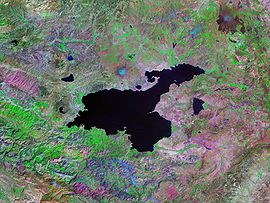
ヴァン湖のランドサット写真
湖の流出は更新世にネムルト山の溶岩流が西方のムシュ平原への流れを塞いだことにより止まっている。現在の休火山では、ネムルト山が湖の西岸を占め、北岸では別の成層火山であるシュプハン山が占めている。
湖の水位はしばしば大きく変動している。オズワルド︵1901年、"Geology of Armenia"︶によれば、タトワン付近では現在の湖面より高い位置の隆起海岸や近年水没した木々もある。1980年代初頭のDegensらの研究では、約18,000年前の氷河期の間は現在より水面が72メートル (236 ft)高かったことが判明した。約9,500年前には劇的な水位の低下があり、現在より300メートル (980 ft)以下の水位となった。続いて、約6,500年前には水位の劇的な上昇が起こっている[2]。
最近でも小さな水位の変動が起きている。1990年代には少なくとも3 m上昇し多くの農地が水没した。2004年までの10年間では約2 m上昇している[1]。
ヴァン湖には周囲の平野と渓谷の浸食による大量の堆積物と、時々発生する隣接する火山の噴火による火山灰が沈殿している。この堆積物の層は厚さが400メートル (1,300 ft)以上と推測され、層状堆積物のボーリングコアに気候学者と火山学者が興味を示している。
1989年と1990年に、ハンブルク大学のステファン・ケンペ博士︵現在はダルムシュタット工科大学の教授︶率いる地質学者の国際チームにより、最大446 m (1,463 ft)までの深さから堆積物コア10個を回収した。これらのコアは堆積物の最初の数メートル貫いただけであったが、これらは最大14,570年分のBPのプロキシ気候データを与えるのに十分な年層を提供した[8]。
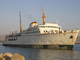
ヴァン湖の鉄道連絡船
水文地質学[編集]

地質学[編集]


余談[編集]
1997年5月に未確認生物のジャノが動画で撮影されたとして話題になった。 湖底に町が沈んでいるという噂があったため、確認したところ紀元前1,000年ごろのウラルトゥ王国時代の古城と都市遺跡が発見された。水の流入が多くなり湖面が上昇したことにより水没したと考えられている[9]。出典[編集]
- ^ a b c Coskun, M.; Musaoğlu, N. (2004) (PDF), Proceedings of the 20th Congress of the International Society for Photogrammetry and Remote Sensing, オリジナルの2008年10月3日時点におけるアーカイブ。
- ^ a b c d e Degens, E.T.; Wong, H.K.; Kempe, S.; Kurtman, F. (June 1984), “A geological study of Lake Van, eastern Turkey”, International Journal of Earth Sciences (Springer) 73 (2): 701–734, doi:10.1007/BF01824978
- ^ Rojnameya AVESTA Archived 2013年9月27日, at the Wayback Machine.. Avestakurd.net. Retrieved on 27 September 2010.
- ^ Kîne em ? – CD 5. Institutkurde.org. Retrieved on 27 September 2010.
- ^ Wong, H.K.; Degens, E.T. (1978), “The bathymetry of Lake Van, eastern Turkey”, Geology of Lake Van, Ankara: General Directorate of Mineral Research and Exploration, pp. 6–10
- ^ Tomonaga, Yama; Brennwald, Matthias S.; Kipfer, Rolf (2007) (PDF), Spatial variability in the release of terrigenic He from the sediments of Lake Van (Turkey), 4th Mini Conference on Noble Gases in the Hydrosphere and in Natural Gas Reservoirs, doi:10.2312/GFZ.mga.045
- ^ Sari, Mustafa (2008), “Threatened fishes of the world: Chalcalburnus tarichi (Pallas 1811) (Cyprinidae) living in the highly alkaline Lake Van, Turkey”, Environmental Biology of Fishes (Springer Netherlands) 81 (1): 21–23, doi:10.1007/s10641-006-9154-9.
- ^ Landmann, Günter; Reimera, Andreas; Lemcke, Gerry; Kempe, Stephan (June 1996), “Dating Late Glacial abrupt climate changes in the 14,570 yr long continuous varve record of Lake Van, Turkey”, Palaeogeography, Palaeoclimatology, Palaeoecology (Elsevier Science B.V.) 122 (1–4): 107–118, doi:10.1016/0031-0182(95)00101-8
- ^ “Ancient Ruins Discovered Under Lake in Turkey” (英語). History. nationalgeographic (2017年11月15日). 2022年9月7日閲覧。
関連項目[編集]
| 全般 |
|
|---|---|
| 国立図書館 |
|