アメリカ合衆国の地理
北アメリカにあるアメリカ合衆国における地理の概略
アメリカ合衆国の地理︵アメリカがっしゆうこくのちり、英: Geography of the United States︶では、主に北アメリカ大陸にあるアメリカ合衆国本土の地理を概説する。アメリカ合衆国は西半球にある国であり、北アメリカ大陸にある48州と、やはり北アメリカ大陸の北西半島部の大半を占めるアラスカ州、また太平洋の列島であるハワイ州によって構成される。太平洋やカリブ海にもアメリカ合衆国の領土がある。﹁アメリカ合衆国﹂を地理的な意味合いで使うときは、大陸部合衆国、アラスカ、ハワイ、プエルトリコ、グァム、アメリカ領ヴァージン諸島の全体を含む。
[1] 陸続きの国境はカナダおよびメキシコと接し、海による国境はロシア、キューバおよびバハマと接している。

| |
| レリーフマップ | |
| 面積 | |
| 総面積 | 3,717,813 平方マイル 9,629,090 km2 |
| 陸地面積 | 3,536,294 平方マイル 9,158,960 km2 |
| 水域面積 | 181,519 平方マイル 470,131 km2 |
| 緯度 | 38°0' N |
| 経度 | 97°0'W |
| 国境 | |
| カナダ国境 | 5,526 マイル 8,893 km |
| メキシコ国境 | 2,067 マイル 3,327 km |
| 海岸線 | 12,380 マイル 19,920 km |
| 専有水域 | |
| 接続水域 | 24 海里 (44 km) |
| 経済水域 | 200 海里 (370 km) |
| 領海 | 12 海里 (22 km) |
面積
編集
総面積︵陸地と領海の合計︶においてアメリカ合衆国と中華人民共和国︵以下では中国と略す︶は拮抗しており、アメリカ合衆国は世界で3番目か4番目の大国になる[2]。両国よりも上位の国はロシアとカナダであり、第5位はブラジルである。領海を除く陸地面積だけで見れば、アメリカ合衆国はロシアと中国に続いて第3位であり、カナダよりも上位に来る[3]。
アメリカ合衆国と中国のいずれが上位であるかは、次の2つの要因によって左右される。(1)中国のアクサイチンとトランス・カラコルム地域に関する領有権主張の有効性をどのように評価するか。どちらの地域もインドが領有権主張している。(2)アメリカ合衆国がその表面積をどのように計算するか。CIAは当初の﹁ワールド・ファクトブック﹂を発行して以来、何度もアメリカ合衆国の総面積を更新してきた[4]。1989年から1996年の総面積は9,372,610 km2 であり、この時は陸地と内陸水域の合計である。これが1997年には五大湖地方と海岸部の水域が加算され、9,629,091 となり、2004年には9,631,418 km2、2006年には9,631,420 km2、2007年には領海が加算されて9,826,630 km2 と変わってきた。現在のCIA﹁ワールド・ファクトブック﹂では9,826,675 km2 となっている[5]。また国際連合統計局では9,629,091 km2[6]、﹁ブリタニカ百科事典﹂では9,522,055 km2という数字を挙げている。
概観
編集
アメリカ合衆国は、北のカナダと南のメキシコと国境を接し、北西部ではロシアと領海の国境がある。大陸部48州は西に太平洋、東に大西洋、南東部はメキシコ湾で仕切られている。アラスカ州は南に太平洋、西にベーリング海峡、北は北極海となっている。またハワイ州は太平洋上にあり、本土からは南西に遙か離れている。
48州はカナダとメキシコの間で一つの地域となっており、様々な正確さや形式に合わせて﹁大陸合衆国﹂あるいは﹁アメリカ合衆国本土﹂と呼ばれ、また﹁ローワー48州﹂と呼ばれることもある。アラスカ州は﹁アメリカ合衆国本土﹂という言葉では含まれて居らず、本土とは間にカナダを置いて、北アメリカ大陸北西端にある。ハワイ州は太平洋上の列島である。首都ワシントンD.C.はメリーランド州から提供された連邦保有地にある︵バージニア州も土地を提供したが、1847年に返還された︶。合衆国はその他に、独立性と統治機構への組み込みの程度が異なる複数の海外領土を所有している。
自然地理学の分類
編集
アメリカ合衆国の東部は地勢的に多様である。テキサス州とメキシコの国境からフロリダ半島を含みニューヨーク市まで、メキシコ湾と大西洋の海岸には広く平らな海岸平原がある。そこから内陸にはうねりのある丘陵部と温帯樹林がある。アパラチア山脈は低い山の並びであり、東部の海岸と五大湖地方やミシシッピ川盆地とを分けている。五大湖は合衆国の北中部にあり、そのうち4つはカナダとの国境になっている。南東部には亜熱帯雨林があり、メキシコ湾岸の特にフロリダ州ではマングローブ湿地がある。アパラチア山脈の西にはミシシッピ川盆地があり、その東側にオハイオ川とテネシー川の2つの大きな支流がある。オハイオ川とテネシー川の流域および中西部は大半がうねりのある丘陵と生産性の良い農地であり、メキシコ湾岸まで南に延びている。
グレートプレーンズはミシシッピ川の西、ロッキー山脈の東にある。合衆国農業生産高のかなりの量がこのグレートプレーンズで栽培されている。グレートプレーンズが農地に転換される以前は、東部平原の丈の高いプレーリーから西部ハイプレーンズの丈の低いステップまで広大な草地が拡がっていた。ミシシッピ川岸近くの数百フィート地点から標高が少しずつ高まり、ハイプレーンズでは1マイル (1,600 m) 以上の高さになる。この平原の一般的に浅い起伏が幾つかの場所で遮られており、中でも著名なものはオザーク高原とウォシトー山脈である。これらはアメリカ内陸高地と呼ばれ、ロッキー山脈とアパラチア山脈の間では数少ない山地である[7][8]。
グレートプレーンズはロッキー山脈でばっさりと切られている。ロッキー山脈はアメリカ合衆国西部の大半を占めており、カナダから伸びてきて、メキシコ近くまで達している。ロッキー山脈は概して他の大きな山地に比べてかなりなだらかな斜面と低い山頂が並んでおり、数少ない例外としてはワイオミング州のティトン山地とコロラド州のサワッチ山脈がある。ロッキー山脈は連続した一体の山地であると言うよりも多くの小さくて切れ切れの山地からなり、その間に盆地や渓谷の大きな繋がりが形成されている。
ロッキー山脈の西は山間地高原︵山間地西部とも呼ばれる︶であり、ロッキー山脈と、カスケード山脈やシエラネバダ山脈との間の広大で乾燥した砂漠地帯である。その南部の広大な地域はグレートベースンと呼ばれ、塩原、河川流域、および北から南に走る多くの小山地がある。アメリカ合衆国南西部は大半が低地砂漠地帯である。フォーコーナーズ地域を中心とするコロラド高原と呼ばれる地域の景観は世界で最も壮観だと考えられている。中でもグランドキャニオン、アーチーズおよびブライスキャニオンなどの国立公園が見物である。
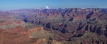
モランポイントから眺めるグランドキャニオン、国内でも有数の観光 地である
山間地高原はカスケード山脈やシエラネバダ山脈で終わりとなる。カスケード山脈は大半が断続的な火山からなり、周囲と比べてひときわ高い。その南のシエラネバダ山脈は高く、岩が多く密な山地である。ここには標高14,505 フィート (4,421 m) で48州の中では最高峰のホイットニー山がある。ここにも素晴らしい景色の場所があり、ヨセミテやレーニア山国立公園となっている。カスケード山脈とシエラネバダ山脈の西はカリフォルニア州のセントラルバレーやオレゴン州のウィラメットバレーなど、一連の川の流域がある。海岸に沿っては太平洋岸山地など一連の低い山地が並ぶ。太平洋岸北西部の海岸の大半は、熱帯以外では最も密な植生が拡がり、セコイアのような世界最高の樹高をもつ樹木もみられる。
アラスカ州では国内で最も表情豊かで未開発の景色をみることができる。広く平らなツンドラ平原から高く形の良い山岳が急に立ち上がっている。アラスカ州南部および南西部海岸沖の諸島には多くの火山がある。ハワイ州は太平洋上でアラスカ州の遙か南にあり、熱帯の火山島が連なり、東アジアやアメリカ合衆国本土からの観光客に人気がある。
アメリカ合衆国の地理はその広大な領域の中で様々に変化する。大陸アメリカ合衆国の中に8つのはっきりとした自然地理学的分類があり、そのそれぞれがさらに幾つかの小区分に分けられる[9]。主要区分は以下の通りである。
●ローレンシア・アップランド - カナダ楯状地の一部、五大湖地方まで拡がる。
●大西洋岸平原 - 大西洋岸とメキシコ湾岸に拡がる東部と南部の海岸地域、大陸棚を含む。
●アパラチア高地 - アメリカ合衆国東部にあり、アパラチア山脈、ワチャング山脈、アディロンダック山地、およびもともとは東部大森林を擁していたニューイングランドが含まれる。
●内陸平原 - 大陸アメリカ合衆国内陸部の一部、グレートプレーンズと呼ばれる地域の大半を含む。
●内陸高地 - これも大陸アメリカ合衆国内陸部の一部、ここにはオザーク高原がある。
●ロッキー山系 - アメリカ山系の1支脈、西部州から遠い内陸にある。
●山間地高原 - コロンビア川台地とコロラド高原およびベイスン・アンド・レンジに分けられる、ロッキー山脈と太平洋山系との間の高原、盆地、山脈および峡谷の並びである。グランドキャニオン、グレートベースンおよびデスバレーがある。
●太平洋山系 - 海岸山脈、アメリカ西海岸がある。

ユタ州アーチーズ国立公園のデリケートアーチ
アメリカ合衆国の大西洋岸は例外的な低地である。アパラチア高地は、地質時代の最初期に起こった、現在のアパラチア山系が形成される契機となった地殻変動によって北東から南西の方向に斜めに造山された。この山系はかなり昔︵おそらくはペルム紀︶に地殻変動のピークを迎えており、その後徐々に起伏の少ないなだらかな地形になってきた。現在の高度は初期の線にそって隆起が繰り返されたか、現在の山地として最も浸食されにくい岩石が残ったことによって生まれたものである。海岸の斜めの構造線は、比較的最近の地殻変動︵北東部に沈降を引き起こし、それによって陸地が海に浸食された︶ながければさらに顕著であったはずである。さらに南東部で隆起が起こり、海岸線の発達をもたらした。
下図は自然地理学地図と呼ばれる地球科学者が用いる地図で、アメリカ合衆国本土48州の地域について地理と地勢の情報を示している。この地図には地形だけでなく海上に陸地が現れた年代も記されている。

アメリカ合衆国の自然地理学的地域
大西洋岸が相対的に低地であるのに対し、太平洋岸は幾らかの例外はあるものの、丘陵や山が多い。この海岸は主に地質学的には最近の地殻変動で形成されており、ゆえに大西洋岸よりも起伏に富んでいる。
大西洋岸には低地が広がり太平洋岸には丘陵や山が多いという地理的特徴は、アメリカ合衆国内の山地分布にも影響している。東海岸のアパラチア山系は当初森林に覆われ、比較的低く狭く、南東と南は重要な海岸平原で遮られている。大陸西側の山脈は高く広く、ロッキー山脈系と太平洋山脈系の2つの支脈が複雑に入り組んでいる。こうした山脈系の間に山間地高原がある。北西部の海岸は深い森林で覆われているが、北西部において他に樹木が見られるのは高山帯以下の高度が高い地域のみである。山間地渓谷、高原および盆地には樹木が生えていないか砂漠であり、南西部では大変乾燥した地帯となっている。
コロンビア川とコロラド川の水源は山系の東端近くにあり、高原や山間地盆地を通って太平洋に注いでいる。
ローレンシア高地、内陸平原および内陸高地は2つの大洋の間にあり、メキシコ湾岸から北に延びてカナダ国境を越え、北極海に至っている。中央平原はカナダ側とアメリカ合衆国側とでは︵ほとんど知覚できないが︶標高が異なる。大ミシシッピ水系はアメリカ合衆国側から発し、南に流れメキシコ湾に注ぐ。ミシシッピ川上流とオハイオ川盆地の幾らかは半乾燥平原であり当初から樹木は川沿いだけにあった。アパラチア山脈に向かう高地は東部大森林地域に含まれ、平原の西部は大変乾燥した気候なので植生は疎らであり、南部は地質的に不毛である。
標高の極値


気候
編集

アメリカ合衆国は地理的に大きく幅広い範囲に跨っているために、地球上にあるほとんどあらゆる気候帯の例が見られる。大半の地域では温暖であり、深南部では亜熱帯、ハワイ州とフロリダ州南部では熱帯、アラスカ州では寒帯、西経100度より西のグレートプレーンズでは亜乾燥帯となっている。主要な農業地域では干ばつが滅多に起こらず、一般に広い範囲に水洪水の被害が及ぶことはなく、適度に降水がある温暖な気候が広がるなど、アメリカ合衆国の気候は比較的農業に適しており、その恩恵を受けて合衆国は大国に成長した。

2006年のノーイースターによるブリザードでの積雪、ニューヨー ク市、ブルックリン
アメリカ合衆国の天候は寒帯ジェット気流︵北太平洋から大きな低気圧をもたらす︶の影響を大いに受けている。この低気圧が含む湿気の大半は、低気圧が東に進みカスケード山脈、シエラネバダ山脈およびロッキー山脈を通過する過程で失われる。湿気の多くは、低気圧がハイプレーンズに達するまでの間に降水によって失われる。しかしながら低気圧がグレートプレーンズを越えると平地が広がっているため低気圧は再び発達し、気団の衝突が起こりうる。さらにメキシコ湾の湿気が北上する現象がしばしば起こるが、この湿気が強力なジェット気流と組み合わされることで、特に春と夏に激しい雷雨が起こることがある。晩冬や春にはこの嵐が東海岸や大西洋で別の低気圧と結びつき、急速に激しさを増すことがある。この嵐はノーイースターと呼ばれ、しばしば大西洋岸中部やニューイングランドの広い範囲で深い積雪をもたらす。グレートプレーンズが広大な平坦地であることが原因となり、世界各地に異常気象が波及することもある。例えば、地形の影響でグレートプレーンズ上空にてジェット気流の流路が蛇行し、それによって熱波や寒気団が猛威を振るうことがある。
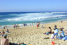
ハワイ州は一年中熱帯気候であり、多くの海浜で知られる。写真はオ アフ島海岸
グレートベースンとコロンビア高原︵山地間高原︶は乾燥または亜乾燥地域であり、カスケード山脈やシエラネバダ山脈の雨蔭にある。年間平均降水量は15インチ (38 cm) 以下である。アメリカ合衆国南西部は暑い砂漠地帯であり、夏季の気温は数週間にわたって 100°F(38℃) を超える。南西部とグレートベースンは、7月から9月までカリフォルニア湾から吹くモンスーンにも影響され、局地性のある激しい雷雨を運んでくることが多い。
カリフォルニア州の大半は10月から4月まで過剰なくらいの降雨があり、それ以外の季節はほとんど雨が降らない地中海性気候になっている。太平洋岸北西部では一年中降水があるが、冬と春はかなり多い。
太平洋岸北西部では大陸アメリカ合衆国の何処よりも降水量が多く、ワシントン州のキノールト・レンジャーでは年間平均降水量が137インチ (3,480 mm) となっている[10]。ハワイ州ではさらに多くの雨が降り、カウアイ島のワイレアレ山では年間降水量が460インチ (11,700 mm) にもなる。南西部のモハーヴェ砂漠は、アメリカ合衆国でも最も乾燥した地域である。アリゾナ州ユマでは毎年2.63インチ (67 mm) の雨しか降らない[11]。
西部の山岳の降水量は豊富で、降雪も多い。特にカスケード山脈は世界でも積雪の多い場所であり、年間平均降雪量は600インチ (1,520 cm) 以上に達する[12]。ただし多雪地帯は標高の高い山岳部に限定されるため、人々の暮らしへの影響はほとんどない。年間平均降雪量での最大はワシントン州のレーニア山であり、692インチ (1,758 cm) であり、1971年から1972年の冬には1,122インチ (2,850 cm) だった。この記録はワシントン州北西部のベイカー山スキー場で、1989年から1999年の降雪シーズンに1,140インチ (2,896 cm) という記録で破られた。カスケード山脈以外での降雪の多い場所としては、グレートソルト湖に近いワサッチ山脈やタホ湖に近いシエラネバダ山脈があり、カリフォルニア州のトラッキーの年間平均降雪量は516.6 cmに達し、人口1万人以上の全米の町では最多である。
東部では西部の降雪量のレベルには届かないものの五大湖の近辺や北東部のアディロンダック山地やアパラチア山脈で降雪量が多い。エリー湖やオンタリオ湖の南岸部は湖水効果雪の影響で、アメリカの平野部では最も降雪量が多い地域である。全米の都市で最も降雪量の多いシラキューズの年間平均降雪量は305.3cm、過去最高の年間降雪量が488cm、最深積雪が121.9cmと日本の日本海側の都市部と比べるとずっと少ない。より大都市になると、ニューヨーク州バッファローやロチェスターが多雪都市であり、バッファローの最深積雪は114.3cmで全米の都市部ではシラキュースの121.9cmに次ぐ記録である。ボストンらワシントンにかけての北東部の沿岸部でもノーイースターと呼ばれる低気圧の影響により、突発的に大雪をもたらすことがあり、積雪40 - 80cm程度の大雪になることがあるが、平均年間降雪量は30 - 100cm未満と少ない。
アメリカ合衆国の中央部は、世界で最も竜巻が発生しやすい地域で[13]、春と夏によく発生する。大西洋岸とメキシコ湾では恐ろしく破壊的なハリケーンがほぼ毎年発生する。アパラチア地域と中西部では大きな洪水が発生する。ただしアメリカ合衆国のどこでも洪水と無縁な地域は無い。南西部は酷い干魃に見舞われる。ある時には500年間以上もの間旱魃が続き、アナサジ人の人口を激減させたと考えられている[14]。西部は夏季に乾燥するため、毎年大規模な山火事に見舞われる。


過去の記録
編集
アラスカ州北部ではツンドラと極地性の気象条件にあり、気温が −80°F(−62℃) まで下がったことがある[15]。一方、カリフォルニア州デスバレーでは気温 134°F(56.7℃) に達し、世界でも2番目の高温記録となった[16]。
アメリカ本土での最低気温極値は、1954年1月20日にモンタナ州Rogers Pass︵標高1710m︶ において記録した −70°F(−56.5℃)[17]である。
アメリカ中西部〜南部からメキシコ湾沿岸にかけての地域は、北極からの寒気を遮る山脈が無いため、緯度のわりに猛烈な冷え込みを記録することがある[18]。リンカーン(−36.1℃)、シカゴ(−32.8℃)、デモイン(−32.2℃)、シンシナティ(−32℃)、インディアナポリス(−32.7℃)、オマハ(−31.7℃)、カンザスシティ(−30.6℃)、コロンバス(−30℃)、ルイビル(−30℃)では最低気温極値は−30℃台であり、より南部に位置するナッシュビル(−27.2℃)、メンフィス(−25℃)やアトランタ(−22.2℃)、ハンツビル(−23.9℃)でも−20度以下まで下がっている。テキサス州内陸部でもアマリロ(−25.5℃)、ラボック(−26.6℃)、アビリーン(−22.8℃)、エルパソ(−22.2℃)、ダラス(−18.3℃)、サンアントニオ(−17.7℃)など軒並み−15℃以下まで下がっており、モービル(−16.1℃)、ペンサコーラ(−15℃)、タラハシー(−14.4℃)、ジャクソンビル(−13.8℃)、ヒューストン(−13.8℃)などのメキシコ湾に近い地域でも−10℃以下の気温を観測したことがあるなど、普段は温暖なフロリダ半島北部やメキシコ湾沿岸地域でも氷点下まで下がることも珍しくない。
自然災害
編集
アメリカ合衆国は毎年様々な自然災害を受けている。干魃は希だが、1931年から1942年にかけて起こったダストボウルのように時として大きな損害をもたらしてきた。ダストボウル発生時にはプレーン全体の農地が被害を受け、地域に人が居なくなり、砂嵐が土地を覆った。

テキサス州ディミット近くの竜巻、1995年6月2日
アメリカ合衆国は世界でも群を抜いて強烈な竜巻が起こる頻度が高い[19][20][21]。グレートプレーンズや中西部では対照的な気団が発生するために、春と夏にしばしば激しい雷雨や竜巻が発生する。テキサス州北部から北にカンザス州と東のテネシー州に抜ける一帯は竜巻道とも呼ばれ、竜巻シェルターを備えた家や竜巻警報を備えた町も多くある。
その他にアメリカ合衆国をしばしば襲う自然災害はハリケーンである。メキシコ湾岸から大西洋岸までの全域および太平洋のハワイ州が被害に見舞われる。特に危険性が高いのがテキサス州の中部と南部海岸、ルイジアナ州南東部からフロリダ州パンハンドルにかけて、フロリダ州東海岸、ノースカロライナ州のアウターバンクなどだが、沿岸部はどこでも襲われる可能性がある。ハリケーンのシーズンは通常6月から11月であり、8月半ばから10月初めに多い。これまでのハリケーンの中でも大きかったのは、1900年のガルベストン・ハリケーン、1992年のハリケーン・アンドリュー、2005年のハリケーン・カトリーナなどだった。東太平洋で発生した熱帯サイクロンの名残が、時として南西部を襲うことがあり、激しい降雨になる。

2005年のハリケーン・カトリーナ通過後、ミシシッピ州ガルフポー トの惨状
時として大きな洪水に見舞われることがある。1927年のミシシッピ大洪水、1993年のアメリカ中西部大洪水、および1982年から1983年の西部におけるエル・ニーニョ現象による広い範囲の洪水と地滑りなどが挙げられる。しかし、地域を限定した洪水はどこでも起こる可能性があり、多雨による地滑りは山岳部全域、特に南西部で問題になっている。西部の広い砂漠地帯の低木は山火事を拡大させる可能性が強い。西部山岳地帯の多くには狭い谷があり、夏のモンスーンシーズンに激しい雷雨に見舞われると時として鉄砲水が起こりることがある。さらにノースイースター暴雪は北東部の住民生活をマヒさせてしまうこともある︵激しい暴雪はほとんどどこでも可能性がある︶。
大陸アメリカ合衆国の西海岸とアラスカ地域︵アリューシャン列島、アラスカ半島およびアラスカ南部海岸を含む︶は環太平洋火山帯の一部であり、地震源となる地殻変動と火山活動が盛んな地域である。北西部はアメリカ合衆国の中でも活火山が集中した地域であり、とくにカスケード山脈に沿ったワシントン州、オレゴン州およびカリフォルニア州北部に集中している。ハワイ諸島にも幾つかの活火山があり、特にキラウエア火山は1983年以降噴火が続いているが、島民にはそれほど影響を与えていない。17世紀以降ハワイ諸島で人命を脅かすような噴火は起きていない。ワシントン州のセント・ヘレンズ山で起こった1980年の噴火のように火山の爆発は時として破壊的なものになる。
環太平洋火山帯の活動によってカリフォルニア州とアラスカ州南部は特に地震に襲われやすい。1906年のサンフランシスコ地震や1964年にアラスカ州アンカレッジ近くで起こった聖金曜日地震は大きな被害を出した。カリフォルニア州は地震活動が頻繁なことで知られており、人命と資産の損失を抑えるために大型構造物は耐震構造にすることが求められている。破壊的な地震以外にも日常的に小さな地震が起こっている。
その他の自然災害としては太平洋盆地の津波、カリフォルニア州の地滑り、および西部の森林火災が挙げられる。


公有地
編集- 国立公園のリスト
- 国有林のリスト(英文)
- 自然保存地域のリスト(英文)
- その他公有地のリスト(英文)
脚注
編集
(一)^ “7 FAM 1100 "Acquisition and Retention of U.S. Citizenship and Nationality"” (PDF). U.S. Department of State. U.S. Department of State. 2009年1月20日閲覧。
(二)^ 国の面積順リスト
(三)^ Yahoo's chart of countries by land area based on the CIA World Factbook http://education.yahoo.com/reference/factbook/countrycompare/area/3d.html;_ylt=As1XMsN8kgSx746VWazy_s7PecYF
(四)^ Countries of the World: 21 Years of World Facts, geographic.org 2008年8月17日閲覧。.
(五)^ “United States”. The World Factbook. CIA (2009年9月30日). 2010年1月5日閲覧。
(六)^ “Population by Sex, Rate of Population Increase, Surface Area and Density”. Demographic Yearbook 2005. UN Statistics Division. 2008年3月25日閲覧。
(七)^ “Managing Upland Forests of the Midsouth”. United States Forestry Service. 2007年10月13日閲覧。
(八)^ “A Tapestry of Time and Terrain: The Union of Two Maps - Geology and Topography”. United States Geological Survey. 2007年10月13日閲覧。
(九)^ “Physiographic Regions”. United States Geological Survey (2003年4月17日). 2008年1月30日閲覧。
(十)^ National Atlas, Average Annual Precipitation, 1961-1990, URL accessed 15 June 2006.
(11)^ Hereford, Richard, et al., Precipitation History of the Mojave Desert Region, 1893-2001, U.S. Geological Survey, Fact Sheet 117-03, URL accessed 13 June 2006.
(12)^ [1]
(13)^ NOVA, Tornado Heaven, Hunt for the Supertwister, URL accessed 15 June 2006.
(14)^ O'Connor, Jim E. and John E. Costa, Large Floods in the United States: Where Thley Happen and Why, U.S. Geological Survey Circular 1245, URL accessed 13 June 2006.
(15)^ Williams, Jack Each state's low temperature record, USA today, URL accessed 13 June, 2006.
(16)^ “Weather and Climate” (PDF). Official website for Death Valley National Park. National Park Service U. S. Department of the Interior. pp. 1-2 (2002年1月). 2006年10月5日閲覧。
(17)^ “Top Ten Montana Weather Events of the 20th Century”. National Weather Service Unveils Montana's Top Ten Weather/Water/Climate Events of the 20th Century. National Weather Service. 2007年3月9日閲覧。
(18)^ Temperature- Lowest of Record NCDC 2010年3月24日 閲覧
(19)^ infoseek
(20)^ 竜巻#竜巻の発生地域
(21)^ Britannicaのうち"Occurrence in the United States"の項
![[1]](http://www.relayweather.com/annualSnowFall.jpg)
関連項目
編集- アメリカ合衆国の郡
- アメリカ合衆国の地域
- アメリカ合衆国の極地
- アメリカ合衆国のフィヨルド(英文)
- アメリカ合衆国の地理中心(英文)
- プエルトリコの地理(英文)
- アメリカ合衆国東部の地理
- アメリカ合衆国内陸の地理(英文)
- アメリカ合衆国西部の地理
- アメリカ合衆国の歴史的地域(英文)
- アメリカ合衆国の島一覧(英文)
- アメリカ合衆国の地形の一覧(英文)
- アメリカ合衆国の山の一覧(英文)
- アメリカ合衆国の河川の一覧
- 長さ順のアメリカ合衆国の河川の一覧
- 北アメリカ大陸の砂漠の一覧(英文)
- アメリカ合衆国政府指定地の一覧(英文)
- アメリカ合衆国の高峰一覧(英文)
- 公有地測量システム
- アメリカ合衆国の地域の一覧(英文)
- アメリカ合衆国領土の変遷
- 米露国境
参考文献
編集- Brown, Ralph Hall, Historical Geography of the United States, New York : Harcourt, Brace, 1948
- Stein, Mark, How the States Got Their Shapes, New York : Smithsonian Books/Collins, 2008. ISBN 9780061431388
外部リンク
編集- United States Geological Survey - Maintains free aerial maps