カリブ海地域
カリブ海と、その海域の島々、周辺海域から構成される地域
カリブ海地域(カリブかいちいき、英語: The Caribbean、スペイン語: Caribe、オランダ語: ![]() Caraïben、カリブ・ヒンドゥスターニー語: कैरिबियन (Kairibiyana); フランス語: Caraïbe ないし Antilles)は、カリブ海と、その海域の島々(カリブ海域内の島々や、カリブ海と北大西洋の境界を成す島々)および周辺海域から構成される地域を指す。
Caraïben、カリブ・ヒンドゥスターニー語: कैरिबियन (Kairibiyana); フランス語: Caraïbe ないし Antilles)は、カリブ海と、その海域の島々(カリブ海域内の島々や、カリブ海と北大西洋の境界を成す島々)および周辺海域から構成される地域を指す。
 | |
| 面積 | 2,754,000 km2 (1,063,000 sq mi) |
|---|---|
| 陸地面積 | 239,681 km2 (92,541 sq mi) |
| 人口(2016年) | 43,489,000[1] |
| 人口密度 | 181.4/km2 (470/sq mi) |
| 民族 | アフリカ系カリブ人、白人系カリブ人、インド系カリブ人、中国系カリブ人[2]、アラワク族(カリブ族、タイノ族) |
| 住民の呼称 | カリビアン、カリブ人、西インド人 |
| 言語 |
カリブ海地域の言語 スペイン語、英語、フランス語、オランダ語、フランス語系クレオール諸語、英語系クレオール諸語、カリブ・ヒンドゥスターニー語、その他 |
| 政府 |
13 主権国家 17 海外領土・自治領 |
| 主要都市 |
カリブ海地域の都市の一覧 |
| Internet TLD | 一覧 |
| 国際電話番号 | 一覧 |
| 時間帯 | UTC-5 to UTC-4 |
概要
編集
カリブ海地域はメキシコ湾と北アメリカ大陸の南東、中央アメリカの東、南アメリカ大陸の北に位置している。日本語ではカリブ地域、あるいはこの地域にある国を総称してカリブ諸国とも呼ばれる。
この地方の大部分はカリブプレート上にあり、域内には700以上の島嶼、岩礁、キー︵サンゴ礁上の低い島︶などがある︵カリブ海地域の島の一覧︶。島々の多くは島弧を形成して、カリブ海のと東渕と北縁となっている[3]。カリブ海地域の島々は、北側の大アンティル諸島と、南および東側の小アンティル諸島︵リーワード・アンティル諸島を含む︶ から成り、大アンティル諸島やカリブ海より北に位置するバハマ諸島︵バハマからタークス・カイコス諸島に至る範囲︶をも含んだ、より広い範囲を指す表現としての西インド諸島の一部となっている。広い意味では、大陸の一部であるベリーズ、ベネズエラ、ガイアナ、スリナム、フランス領ギアナもカリブ海地域に含める場合がある。
地政学的には、カリブ海地域の島々は北アメリカの下位区分 (subregion) と見なされることが多く[4][5][6][7][8]、合わせて30の主権国家、海外県、属領から成っている。1954年12月15日から2010年10月10日まで、5つの統治体から成るオランダ領アンティルと称されたオランダ属領があった[9]。また、1958年1月3日から1962年5月31日まで、イギリス属領であった英語圏の領域が構成した、西インド連邦と称された短命な自治国が存在していた。クリケット西インド諸島代表は、その後も、これら諸国の多くを代表して編成され続けている。
語源と発音
編集
この地方の名称は、スペインによる征服の時期に、小アンティル諸島や近在の南アメリカ大陸の一部にいた民族であるカリブ族の名から採られている[10]。
︵英語において︶﹁Caribbean﹂の最も一般的な発音は2種類あり、KARR-ə-BEE-ən と第3音節にアクセントを置くものと、kə-RIB-ee-ən と第2音節に置くものがある。前者の方が歴史が古いが、第2音節に強勢を置く発音も、既に75年以上の歴史がある[注釈1]。イギリス英語の話者は KARR-ə-BEE-ən を好み、北アメリカ英語の話者は典型的には kə-RIB-ee-ən を用いるとされるが[11]、諸文献の間には一致した見解は見いだされない[12]。カリブ海地域の英語話者の間でも、一致は見られない[13]。
様々な定義
編集
﹁カリブの﹂を意味する英語の単語﹁Caribbean﹂は、様々な含意で使われることがある。おもな使い方は、地理的、政治的な意味である。しかし、この言葉でさす対象は拡張され、奴隷、ヨーロッパによるアメリカの植民地化、プランテーションの仕組みなどと、文化的、歴史的に強く結び付いた周辺の領域まで包含することがある。
●国連による世界地理区分において、カリブ海地域はアメリカ州の一部と位置づけられている。
●自然地理学的には、カリブ海地域はカリブ海を取り巻く列島を中心とする地域である。北側では、メキシコ湾、フロリダ海峡、そして、東側から北東側に広がる北大西洋と隣接している。南側は南アメリカ大陸の海岸線によって区切られている。
●政治的には、この地方で形成された社会経済的グループをおもに意味することがある。例えば、カリブ共同体 (CARICOM) と称する貿易ブロックには、南アメリカのガイアナ協同共和国やスリナム共和国、中央アメリカのベリーズも正式な加盟国として参加している。大西洋上のバミューダ諸島とタークス・カイコス諸島は、準加盟となっており、バハマ国は加盟国となっている。
●また、カリブ諸国連合 (ACS) には、カリブ海地域と周辺にあるほとんどすべての国・地域が参加し、さらに、太平洋にしか面していないエルサルバドルも加盟している。ACSによれば、加盟国の総人口は2億2700万人に達するという[14]。
地理、地質、気候
編集
カリブ海地域の地理と気候は、多様である。この地方の一部の島々では、火山に由来しない平坦な土地しかない。こうした島々の例としては、アルバ︵ごく小規模な火山地形がある︶、バルバドス、ボネール島、ケイマン諸島、セント・クロイ島、バハマ諸島、アンティグア島などがある。他方では、起伏が大きい山稜が聳える、キューバ、イスパニョーラ島、プエルトリコ、ジャマイカ、ドミニカ島、モントセラト、サバ島、セントクリストファー島︵セントキッツ島︶、セントルシア、セント・トーマス島、セント・ジョン島、トルトラ島、グレナダ、セントビンセント島、グアドループ、マルティニーク、トリニダード・トバゴなどの島々もある。
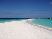
ベネズエラ領ロス・ロケス諸島のカーヨ・デ・アグア (Cayo de Agua)。
大アンティル諸島と小アンティル諸島の範囲の定義も、異なった形で行なわれることがしばしばある。ヴァージン諸島は、プエルトリコの島棚に連なる浅堆上にあるため、しばしば大アンティル諸島の側に入れられる。小アンティル諸島という用語は、列島を指して用いられることがよくあり、グレナダを含み、トリニダード・トバゴやリーワード・アンティル諸島を除外して用いられる。
この地域の気候は熱帯気候であるが、降水量は標高や、島の大きさ、海流などとの関係で多様である。例えば、小アンティル諸島のABC諸島は、打ち寄せる冷涼な湧昇流によって乾燥している。湿潤な貿易風が定常的に東から吹くため、山がちな島々では熱帯雨林と半砂漠に気候が分かれている。時々吹く北西風は、冬季に北寄りの島々に影響を与える。カリブ海地域は、一年を通して日照に恵まれるが、季節は乾季と雨季に判れ、一年の前半よりも後半の6ヵ月のほうが湿潤である。
カリブ海には、豊富な回遊性の魚の群れや、亀などがおり、サンゴ礁の形成も進んでいる。大西洋とカリブ海の縁、プエルトリコ島のすぐ北側に位置するプエルトリコ海溝は、大西洋全域の中でも最も水深が深い場所である[15]。
カリブ海地域は、しばしばハリケーンに見舞われるが、通常は、グレナダより北側、バルバドスより西側が襲われることが多い。おもなハリケーン・ベルトは、カリブ海東部のバルバドス島の北西側まで伸びている
カリブ海地域には、カリブ海と太平洋を結ぶパナマ運河経由の主要な航路がいくつも通っている。


おもな島、群島
編集「カリブ海の島の一覧」を参照
- 小アンティル諸島
- リーワード諸島
- セント・クロイ島
- セント・トーマス島
- セント・ジョン島
- ウォーター島
- トルトラ島
- ヴァージン・ゴルダ島
- アネガダ島
- ヨスト・ヴァン・ダイク島
- アンギラ島
- アンティグア島
- バーブーダ島
- レドンダ島
- セント・マーチン島
- サバ島
- シント・ユースタティウス島
- サン・バルテルミー島
- セントクリストファー島(セント・キッツ島)
- ネイビス島
- モントセラト島
- グアドループ島
- レ・サント諸島
- マリー・ガラント島
- ラ・デジラード島
- ウィンドワード諸島
- ドミニカ島
- マルティニーク島
- セントルシア島
- セントビンセント島
- グレナディーン諸島
- グレナダ島
- カリアク島・プティトマルティニーク島
- バルバドス島
- トバゴ島
- トリニダード島
- リーワード・アンティル諸島
- リーワード諸島
独立国
編集非独立地域
編集脚注
編集注釈
編集- ^ フランク・ホレス・ヴィゼテリーによれば、20世紀初頭には、第1音節にアクセントを置くものだけが正しい発音だとされていた。Frank Horace Vizetelly, A Desk-Book of Twenty-five Thousand Words Frequently Mispronounced (Funk and Wagnalls, 1917), p. 233.
出典
編集
(一)^ Country Comparison :: Population. CIA. The World Factbook
(二)^ McWhorter, John H. (2005). Defining Creole. Oxford University Press US. p. 379. ISBN 0-19-516670-1
(三)^ Asann, Ridvan (2007). A Brief History of the Caribbean (Revised ed.). New York: Facts on File, Inc.. p. 3. ISBN 0-8160-3811-2
(四)^ Standard Country and Area Codes Classifications (M49), United Nations Statistics Division
(五)^ North America Atlas National Geographic
(六)^ "North America" Atlas of Canada
(七)^ "North America". Britannica Concise Encyclopedia; "... associated with the continent is Greenland, the largest island in the world, and such offshore groups as the Arctic Archipelago, the Bahamas, the Greater and Lesser Antilles, the Queen Charlotte Islands, and the Aleutian Islands."
(八)^ The World: Geographic Overview, The World Factbook, Central Intelligence Agency; "North America is commonly understood to include the island of Greenland, the isles of the Caribbean, and to extend south all the way to the Isthmus of Panama."
(九)^ The Netherlands Antilles: The joy of six, The Economist Magazine, April 29, 2010
(十)^ “Carib”. Encyclopædia Britannica. 2008年7月11日時点のオリジナルよりアーカイブ。2008年2月20日閲覧。 “inhabited the Lesser Antilles and parts of the neighbouring South American coast at the time of the Spanish conquest.”
(11)^ Ladefoged, Peter and Johnstone, Keith (2011). A Course in Phonetics. Cengage Learning. pp. 86–. ISBN 978-1-4282-3126-9
(12)^ See, e.g., Elster, supra.
(13)^ Allsopp, Richard and Allsopp, Jeannette (2003). Dictionary of Caribbean English Usage. University of the West Indies Press. p. 136–. ISBN 978-976-640-145-0
(14)^ Background of the business forum of the Greater Caribbean of the Association of Caribbean States (ACS) - ウェイバックマシン︵2010年3月27日アーカイブ分︶. acs-aec.org
(15)^ ten Brink, Uri. “Puerto Rico Trench 2003: Cruise Summary Results”. National Oceanic and Atmospheric Administration. 2008年2月21日閲覧。