
サリバン郡 (ペンシルベニア州)
| ペンシルベニア州サリバン郡 | |
|---|---|
 ラポートにあるサリバン郡庁舎
| |
 郡のペンシルベニア州内の位置
| |
 州のアメリカ合衆国内の位置
| |
| 設立 | 1847年3月15日 |
| 郡庁所在地 | ラポート |
| 最大の都市 | デュショア |
| 面積 - 総面積 - 陸 - 水 |
1,171 km2 (452 mi2) 1,165 km2 (450 mi2) 5 km2 (2 mi2), 0.53% |
| 人口 - (2010年) - 密度 |
6,428人 5人/km2 (14.2人/mi2) |
| 標準時 | 東部: UTC-5/-4 |
| ウェブサイト | www |
サリバン郡︵英: Sullivan County︶は、アメリカ合衆国ペンシルベニア州の中央部北東に位置する郡である。2010年国勢調査での人口は6,428人であり、2000年の6,556人から2.0%減少した[1]。郡庁所在地はラポート・ボロ︵人口316人[2]︶であり、同郡で人口最大の都市はデュショア・ボロ︵人口608人[3]︶である。サリバン郡は1847年3月15日にライカミング郡から分離して設立された。郡名はペンシルベニア州上院の指導者チャールズ・サリバンに因んで名付けられた。

世界の果て州立公園
堆積岩の層序学的見解ではデボン紀ロックヘイブン層︵リッククリーク・バレーでのみ露出︶から石炭層を含むペンシルベニア紀アリゲイニー層まである。概して低地の大半にはキャッツキル層があり、ハントリー山、バーグーン、マウチチャンク、ポッツビルの砂岩が山を覆っている。氷河による迷子石を除いて、いかなる種類の火成岩も変成岩も郡内では見られない。
サリバン郡の岩盤の構造は穏やかな褶曲を受けており、2つの背斜と2つの向斜が、どれもほぼ東西を向いている。マレーとリングデールの町の間にはアリゲイニー層の3つの断層が識別されている[10][11]。
サリバン郡のほぼ全地域が過去の更新世すなわち氷期に何度か氷河作用を受けた[12]。ウィスコンシン紀後期の氷河性礫岩に覆われている。イリノイ紀の堆積物がウィスコンシン紀後期の下にあり、郡南中部︵ダビッドソン・タウンシップの西部︶では露出部がある。
主要河川はロイヤルソック・クリークとマンシー・クリークである。どちらもサスケハナ川西支流に注いでいる。郡東境に沿った水流はサスケハナ川北支流に注いでいる。郡全域がチェサピーク湾水系の中にある。

ロイヤルソック・クリークのヘイスタックス
郡内に小さな炭田が幾つかある[13]。瀝青炭あるいは半無煙炭が含まれ、すべてペンシルベニア紀のものである。
郡内の地質的特徴には次のものがある。
歴史[編集]
サリバン郡となった地域は、1768年にペンシルベニア植民地が第一次スタンウィックス砦条約の一部としてイロコイ族インディアンから購入したものだった。当初はノーサンバーランド郡に、さらに1795年にライカミング郡ができたときはこれに属した[4]。1847年3月15日、ライカミング郡の北東部からサリバン郡が設立された。ライカミング郡の一部から生まれた郡として13番目かつ最後のものだった[4]。 州の公式記録﹃ペンシルベニア州地方政府﹄に拠れば、サリバン郡は州上院議員チャールズ・C・サリバンに因む命名であり、サリバンは郡を設立するための﹁法案成立に積極的な役割を果たした﹂とされている[5]。しかし、歴史家のフレデリック・A・ゴッドチャールズに拠れば、1779年にイロコイ族インディアンに対するサリバン遠征を率いたジョン・サリバン将軍に因む命名だとしている[6]。地理[編集]
アメリカ合衆国国勢調査局に拠れば、郡域全面積は452平方マイル (1,172 km2)であり、このうち陸地450平方マイル (1,165 km2)、水域は2平方マイル (6 km2)で水域率は0.53%である[7]。 郡内の標高は、ダビッドソン・タウンシップにあるノース山の2,593フィート (790 m) から、ライカミング郡との郡境、ロイアルソック・クリークの779フィート (237 m) まで変化している。ペンシルベニア州道87号線、同487号線、アメリカ国道220号線が郡内を抜けている。主要河川としてはロイアルソック・クリーク、リトルロイアルソック・クリーク、マンシー・クリーク、フィッシング・クリークがある。土地の大半は森林だが、特に北部には幾らかの農地がある。南部と西部には多くの川のバレーがある[8]。地質[編集]
サリバン郡はアパラチア高原地理区分の中にあり古生代中期からの後期の穏やかに褶曲し、断層が入った堆積岩が特徴である。郡南端はほぼアリゲイニー・フロントにあり、リッジ・アンド・バレー地理区分とアパラチア高原との境目にあたる[9]。

- ヘイスタックス(ハントリー山層)、デュショアの南、ロイヤルソック・クリークで露出、起源不明の砂岩マウンド
- ガノガ湖、標高2,265フィート (690 m)と郡内では最も高い湖
- リケッツグレン州立公園、多くの滝がある
- 世界の果て州立公園、ハントリー山層の露出部があり、ポッツビル層の砂岩に斜交層理が見られる「ロックシティ」
- リーバーフィンガー採石場(ミルビュー山道路、フォークスビルの北東)、腕足動物の化石、生痕化石、植物化石が見られるロックヘイブン層にある[14]
- グランドビュー、郡南東隅、レッドロック山の頂部にあり、アリゲイニー・フロントの景観を楽しめる
- ティックリッシュロック、ロックラン道路を上がったグレンモーア近くにあり、デボン紀キャッツキル層の岩層が見られる

山[15][編集]
| 山名 | 標高 (m) |
| ハックルベリー山 | 762 |
| ラウンドトップ | 758 meters |
| プロスペクトヒル | 653 |
| トムキンス・コーナー・ビスタ | 644 |
| ハイノブ | 618 |
| ベア山 | 609 |
| ラバーズロック | 609 |
| グースベリーヒル | 592 |
| ミドルヒル | 588 |
| キャンプ山 | 586 |
| ホグバックヒル | 587 |
| ポールヒル | 585 |
| ビッグヒル | 579 |
| ブラウンズビスタ | 554 |
| ランバートヒル | 532 |
| ウォーバートンヒル | 532 |
| モリニューヒル | 531 |
| ライトヒル | 524 |
| シュリンプヒル | 507 |
交通[編集]
郡内の公共交通は、エンドレスマウンテンズ交通公社が担当している。
隣接する郡[編集]

|
ブラッドフォード郡 |
| ||
| ライカミング郡 | ワイオミング郡 | |||
| コロンビア郡 | ルザーン郡 |
人口動態[編集]
| サリバン郡国勢調査データ | |||
|---|---|---|---|
| 年 | 人口 | %± | |
| 1850 | 3,694 | — | |
| 1860 | 5,637 | 52.6% | |
| 1870 | 6,191 | 9.8% | |
| 1880 | 8,073 | 30.4% | |
| 1890 | 11,620 | 43.9% | |
| 1900 | 12,134 | 4.4% | |
| 1910 | 11,293 | −6.9% | |
| 1920 | 9,520 | −15.7% | |
| 1930 | 7,499 | −21.2% | |
| 1940 | 7,504 | 0.1% | |
| 1950 | 6,745 | −10.1% | |
| 1960 | 6,251 | −7.3% | |
| 1970 | 5,961 | −4.6% | |
| 1980 | 6,349 | 6.5% | |
| 1990 | 6,104 | −3.9% | |
| 2000 | 6,556 | 7.4% | |
| 2010 | 6,428 | −2.0% | |
| Sullivan County Census Data[16] [17][18] | |||
|
基礎データ
人種別人口構成
|
先祖による構成
|
年齢別人口構成
世帯と家族(対世帯数)
|
政治[編集]
2012年10月時点でサリバン郡には4,243 人の登録有権者がいた[19]。
●民主党: 1,612 (37.99%)
●共和党: 2,268 (53.45%)
●その他の政党: 363 (8.56%)
サリバン郡はアメリカ合衆国下院議員ペンシルベニア州第10選挙区に属し、2013年時点では共和党議員を選出している。ペンシルベニア州議会上院では第23選挙区に属しており、下院では第110選挙区に属している。2013年時点で上院も下院も共和党が独占している。
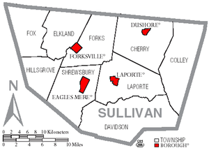
サリバン郡の自治体、ボロは赤、タウンシップは白
ペンシルベニア州法の下では4種類の自治体がある。市、ボロ、タウンシップ、町である。
都市と町[編集]

ボロ[編集]
|
タウンシップ[編集]
|
|
国勢調査指定地域・未編入領域[編集]
|
|
|
|
教育[編集]
公共教育学区[編集]
●サリバン郡教育学区、7年生から12年生を教える高校が1校、幼稚園生から6年生を教える小学校が2校ある。サリバン郡高校はラポート・ボロにある。サリバン郡小学校が高校の裏にある。
公園とレクリエーション[編集]
郡内には2つの州立公園がある ●リケッツグレン州立公園の部分、郡東部にある ●世界の果て州立公園、ロイアルソック・クリーク沿い、フォークスビル近くにある 郡内では毎年幾つかの祭が開催されている。 ●デュショア創設者の日、8月 ●シュショア・デイリーパレード、6月半ば ●ラポート・ファイアマンズ・カーニバル、8月 ●サリバン郡祭、8月下旬から9月上旬脚注[編集]
(一)^ Quickfacts.census.gov - Sullivan County - accessed 2011-12-06.
(二)^ American FactFinder - Laporte, Pennsylvania - accessed 2011-12-06.
(三)^ American FactFinder - Dushore, Pennsylvania - accessed 2011-12-06.
(四)^ abMeginness, John Franklin (1892). History of Lycoming County, Pennsylvania: including its aboriginal history; the colonial and revolutionary periods; early settlement and subsequent growth; organization and civil administration; the legal and medical professions; internal improvement; past and present history of Williamsport; manufacturing and lumber interests; religious, educational, and social development; geology and agriculture; military record; sketches of boroughs, townships, and villages; portraits and biographies of pioneers and representative citizens, etc. etc. (1st Edition ed.). Chicago, IL: Brown, Runk & Co.. ISBN 0-7884-0428-8 2007年8月5日閲覧. "(Note: ISBN refers to Heritage Books July 1996 reprint. URL is to a scan of the 1892 version with some OCR typos)."
(五)^ “Pennsylvania Local Government” (PDF). Commonwealth of Pennsylvania. 2008年2月7日閲覧。
(六)^ Godcharles, Frederic A. (1933). Pennsylvania: Political, Governmental, Military and Civil: Political and Civil History Volume (First edition ed.). New York, New York: The American Historical Society
(七)^ “Census 2010 U.S. Gazetteer Files: Counties”. United States Census. 2013年4月13日閲覧。
(八)^ https://www.google.com/maps?f=d&source=s_d&saddr=+Sullivan,+PA
(九)^ PA Geological Survey Map 13
(十)^ PA Geologic Survey Map 61, Overton Quadrangle
(11)^ Berg, T.M., Edmunds, W.E., Geyer, A.R. and others, compilers, (1980). Geologic Map of Pennsylvania: Pennsylvania Geologic Survey, Map 1, scale 1:250,000.
(12)^ PA Geologic Survey Map 59
(13)^ http://www.dcnr.state.pa.us/topogeo/maps/map11.pdf PA Geologic Survey Map 11
(14)^ The Haystacks, "Ricketts Folly," and The End of the World: Geology of the Glaciated Allegheny High Plateau, Sullivan, Luzerne, and Columbia Counties, Pennsylvania, 71st Annual Field Conference of Pennsylvania Geologists (field trip guide book), J. D. Inners, G. M. Fleeger, eds., 2006
(15)^ http://www.openstreetmap.org/
(16)^ “Sullivan County QuickFacts”. United States Census Bureau. 2011年1月13日閲覧。
(17)^ “Historical Census Browser”. University of Virginia, Geospatial and Statistical Data Center (2004年). 2008年2月17日閲覧。(1850-1960 population data)
(18)^ Richard L. Forstall (1995年3月27日). “Pennsylvania, Population of Counties by Decennial Census: 1900 to 1990”. U.S. Census Bureau. 2008年2月17日閲覧。(1970-1990 population data)
(19)^ http://www.dos.state.pa.us/portal/server.pt/community/voter_registration_statistics/12725%7CPA Department of State
外部リンク[編集]
- Sullivan County Official Website - 公式サイト
座標: 北緯41度27分 西経76度31分 / 北緯41.45度 西経76.51度
| 全般 |
|
|---|---|
| 国立図書館 |
|
| その他 |
|