ラプラタ川
(ラ・プラタ川から転送)
| ラプラタ川 Río de la Plata River Plate, La Plata River | |
|---|---|
 | |
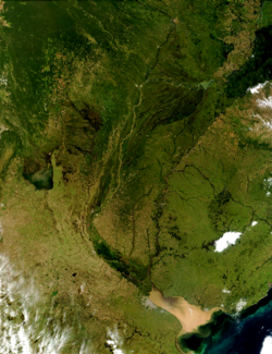
 ラプラタ盆地(ラプラタ水系流域)の地図。 | |
| 名前の由来 | スペイン語で「銀の川」 |
| 現地の呼称 | Río de la Plata (スペイン語) |
| 所在 | |
| 国 | アルゼンチンとウルグアイ |
| 都市 | |
| 特性 | |
| 水源 | パラナ川とウルグアイ川の合流点 |
| • 所在地 | アルゼンチン/ウルグアイ |
| • 座標 | 南緯34度0分5秒 西経58度23分37秒 / 南緯34.00139度 西経58.39361度[1] |
| 河口・合流先 | 大西洋 |
• 所在地 | アルゼンチン海, アルゼンチン |
• 座標 | 南緯35度40分 西経55度47分 / 南緯35.667度 西経55.783度座標: 南緯35度40分 西経55度47分 / 南緯35.667度 西経55.783度[2] |
| 延長 | 290 km (180 mi)[3] 4,876 km (3,030 mi) パラナ川を含む |
| 流域面積 | 3,170,000 km2 (1,220,000 sq mi)[4] |
| 流量 | |
| • 平均 | 22,000 m3/s (780,000 cu ft/s)[3] |
| 流域 | |
| 主な支流 | |
| • 左岸 | ウルグアイ川, San Juan River, en:Santa Lucía River |
| • 右岸 | パラナ川, en:Luján River, Salado River |


ラプラタ川︵ラプラタがわ、スペイン語: Río de la Plata︹リオ・デ・ラ・プラタ︺、ポルトガル語: Rio da Prata、英語: River Plate, La Plata River, Plata River︶は、アルゼンチンとウルグアイの間を流れる川である。河口部が全幅約270kmの三角江︵エスチュアリー︶となっている。
ラプラタ川はウルグアイ川、パラグアイ川、パラナ川の各河川をはじめとする無数の支流を含む巨大な水系としての意味も持ち、その流域面積はおよそ310万km2でパラグアイ全土、ボリビア南東部、ウルグアイの大部分、ブラジルおよびアルゼンチンのかなりの部分を含んでいる。
河口部にはウルグアイの首都モンテビデオ、アルゼンチンの首都ブエノスアイレスがある。
経済[編集]
ラプラタ水系の経済的価値は流域面積の割には小さいといえる。第一の原因として考えられるのは、その水深の浅さである。水系の大部分は船底の浅い船しか航行できないため、ミシシッピ川やドナウ川といった大河のように内陸部まで大型船が遡上できない。灌漑や水力発電に関しても同様に経済性が小さい。[独自研究?]歴史[編集]
1516年、スペインの航海者フアン・ディアス・デ・ソリス︵Juan Díaz de Solís︶が大西洋から太平洋への水路を求めて探検中に﹁発見﹂した。スペイン人はこの川を銀の川であることを願って﹁ラ・プラタ︵Plata=銀、ラは女性定冠詞︶川﹂と命名した。流域の都市[編集]
スペイン人は、植民地の運営のために必要な町を川に沿って建設したが、スペインからの独立後、その多くは独立した新しい国家の首都やその地方の州の州都等へとなったものが多い。ラプラタ川流域の首都所在地[編集]
支流[編集]
関連項目[編集]
- パンパ
- ラプラタ沖海戦
- リオ・デ・ラ・プラタ副王領
- セバスチャン・カボット
- CAリーベル・プレート - ラ・プラタ川にちなんだ、アルゼンチンの名門サッカークラブ
脚注[編集]
(一)^ Río Paraná Guazú - GEOnet Names Server (main distributary of the Río Paraná)
(二)^ “Limits of Oceans and Seas, 3rd edition”. International Hydrographic Organization (1953年). 2011年10月8日時点のオリジナルよりアーカイブ。2020年12月28日閲覧。
(三)^ ab"Río de la Plata". Encyclopædia Britannica. 2015年5月9日時点のオリジナルよりアーカイブ。2010年8月11日閲覧。
(四)^ Raúl A. Guerrero (June 1997). “Physical oceanography of the Río de la Plata Estuary, Argentina”. Continental Shelf Research 17 (7): 727–742. Bibcode: 1997CSR....17..727G. doi:10.1016/S0278-4343(96)00061-1.
外部リンク[編集]
●Proyecto FREPLATA: "Protección Ambiental del Río de la Plata y su Frente Marítimo"環境関係のプロジェクトのページへのリンク︵スペイン語︶。
●﹃南米における河川舟運に関連する海運及び造船業に関する現況調査︵ラプラタ川水系︶﹄一般財団法人 日本船舶技術研究協会、2016年3月。2021年4月4日閲覧。
