
ドナウ川
この記事は英語版、フランス語版、ドイツ語版の対応するページを翻訳することにより充実させることができます。(2023年4月) 翻訳前に重要な指示を読むには右にある[表示]をクリックしてください。
●英語版記事を日本語へ機械翻訳したバージョン︵Google翻訳︶。
●万が一翻訳の手がかりとして機械翻訳を用いた場合、翻訳者は必ず翻訳元原文を参照して機械翻訳の誤りを訂正し、正確な翻訳にしなければなりません。これが成されていない場合、記事は削除の方針G-3に基づき、削除される可能性があります。
●信頼性が低いまたは低品質な文章を翻訳しないでください。もし可能ならば、文章を他言語版記事に示された文献で正しいかどうかを確認してください。
●履歴継承を行うため、要約欄に翻訳元となった記事のページ名・版について記述する必要があります。記述方法については、Wikipedia:翻訳のガイドライン#要約欄への記入を参照ください。
●翻訳後、 {{翻訳告知|en|Danube|…}}をノートに追加することもできます。
●Wikipedia:翻訳のガイドラインに、より詳細な翻訳の手順・指針についての説明があります。
|
| ドナウ川 | |
|---|---|
 | |
| 延長 | 2,860 km |
| 平均流量 | 6,400 m³/s |
| 流域面積 | 817,000 km² |
| 水源 | シュヴァルツヴァルト(ドイツ) |
| 水源の標高 | 678 m |
| 河口・合流先 | 黒海(ルーマニア) |
| 流域 |
ルーマニア(28.9%) ハンガリー(11.7%) オーストリア(10.3%) セルビア(10.3%) ドイツ(7.5%) スロバキア(5.8%) ブルガリア(5.2%) ボスニア・ヘルツェゴビナ(4.8%) クロアチア(4.5%) ウクライナ(3.8%) チェコ(2.6%) スロベニア(2.2%) モルドバ(1.7%) スイス(0.32%) イタリア(0.15%) ポーランド(0.09%) モンテネグロ(0.03%) |
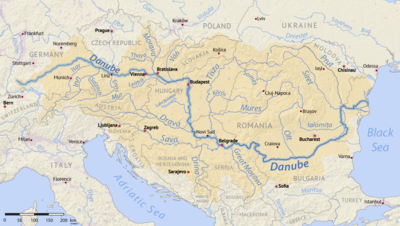
ドナウ川︵ドナウがわ、ラテン語‥Danubius、ドイツ語: Donau [ˈdoːnaʊ]、英語‥Danube︶は、ドイツ南部バーデン=ヴュルテンベルク州のシュヴァルツヴァルト︵黒い森︶に端を発し、概ね東から南東方向に流れ、中欧・東欧10ヶ国以上を通って黒海に注ぐ国際河川である。河口にはドナウ・デルタが広がる。全長2,857km (1,775mi)で、ヨーロッパではヴォルガ川に次いで2番目に長い。
船舶の遡行が可能で、水運上も重要な大河であり、ライン・マイン・ドナウ運河を通じて北海とも結ばれている。

ヨーロッパの分水界を示す地図。赤線が分水界を示す。凡例はドイツ語。

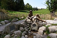
ドナウの泉︵ドナウエッシンゲン︶
ドナウエッシンゲンの町を治めたフュルステンベルク公の城館の庭に、﹁ドナウの泉﹂と呼ばれる泉があり、ここがドナウ川の源泉だと言われている。彫刻などで飾られ観光名所ともなっているが、しかし実際はブリガッハ川に注ぐ支流であり、ここが地理学上の源泉とは見做されない。
また、かつてはもう一つの支流﹁ウニペルスの泉﹂が﹁ドナウの泉﹂と名付けられていた。この泉はドナウエッシンゲン城公園の南の住宅地の中に存在し、市街地の縁を細い流れで下った後、ドナウエッシンゲン城公園の池や水路を経由しブリガッハ川へ合流する。
ブリガッハ川の源泉は、ドナウエッシンゲンより鉄道で2駅ほどのザンクトゲオルゲンという町の郊外にある。
ブレクの泉︵フルトヴァンゲン︶
ドナウ川の地理学上の源泉は本流であるブレク川の源泉である。ブレク川の最上流部フルトヴァンゲンの郊外、海抜1000mほどの山間部に﹁ブレクの泉﹂が湧き出しており、ドナウ川の真の源泉である旨の説明版がある。
尾根を挟んで北東に900mほどの場所にはエルツ川の源泉が湧き出しているが、こちらはライン川へと合流する。通常であればこの2つの泉の水が出会うことはないが、ドナウ上流域は石灰石の浸透性が高い地質であり、一部の水は地下に潜ってライン川流域に流出している。︵ドナウ川浸透︶[3]
他にも近辺にはいくつかの小さな支流の川が流れ、その源泉が湧き出ているが、一方はドナウ川に注ぎ黒海へ至り、もう一方はライン川に注ぎ北海へと至る。これらの境界はヨーロッパの分水界と呼ばれ、ブレクの泉は、この分水界の南東わずか100mほどの場所に位置している。
フルトヴァンゲンには鉄道駅はないが、ドナウエッシンゲンおよび近隣の町トリベルク︵ドイツ最大の滝で有名な町。この滝はライン川に注ぐ︶などからバスが出ている。

リンツのドナウ川
パッサウの下流からはオーストリア領内に入る。リンツを抜けた後、メルク修道院を起点として、30kmほどヴァッハウ渓谷と呼ばれる景勝地が続く。この渓谷には古城や修道院が点在し、またオーストリア最大のワイン産地でもあるため、ブドウ畑の中に城や僧院のたたずむ美しい光景が観光客の人気を集めており、また世界遺産にも指定されている。この渓谷を抜けるとウィーン盆地へと入り、しばらく下流に、オーストリアの首都ウィーンが存在する。ウィーンはハプスブルク帝国の居城として長くドナウ上流地域の中心であった町であり、また市民生活もドナウ川と密接に結びついていた。﹃美しく青きドナウ﹄など、ドナウを主題としてウィーンで作曲された曲も数多く存在する。一方でウィーンはドナウ川の氾濫にも長く悩まされてきた街だが、19世紀後半の河川改修工事によってドナウ川の氾濫は抑えられた。ドナウ川はウィーンの街を抜けて、その下流で小カルパティア山脈を越える、いわゆる﹁ハンガリーの門︵Devín Gate︶﹂と呼ばれる狭隘部を通過する。ここまでがドナウ川の上流部とされる。
ウルム付近の﹁ドナウモース﹂[4]、レヒ川との合流点付近[5]およびウィーン付近の氾濫原の﹁下ローバウ﹂[6]、モラヴァ川との合流点付近[7]はラムサール条約登録地である。下ローバウは﹁ムール・ドラーヴァ・ドナウ5カ国生物圏保護区﹂の一部としてユネスコの生物圏保護区にも指定されている[8]。
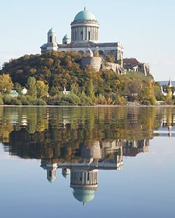
エステルゴム大聖堂
﹁ハンガリーの門﹂の名の通り、ここから下流はハンガリーに属するものと古来されてきた。現在でも、ドナウ川はここでオーストリアから、スロバキアとハンガリーの国境をなすようになる。この門のすぐ下流に、スロバキアの首都ブラチスラヴァが存在する。﹁門﹂で隔てられているとはいえ、ブラチスラヴァとウィーンの距離は60kmにすぎず、オーストリア・ハンガリー帝国時代までは密接な交流があった。またブダがオスマン帝国に占領されていた17・18世紀には、ブラチスラヴァはポジョニと呼ばれ、ハンガリーの首都となっていた。ブラチスラヴァ下流では、かつて大規模ダムの建設計画があったものの、環境保護運動により中止となった︵後述︶。
スロバキア・ハンガリー国境はエステルゴムで終わりを告げ、ここからはハンガリー領内に入る。エステルゴムはハンガリー国王イシュトヴァーン1世が戴冠した歴史ある都市であり、ドナウ河畔には町のシンボルであるエステルゴム大聖堂が立っている。エステルゴムのすぐ下流、ドナウベンドと呼ばれる地域でドナウ川は東から南に流れの向きを変え、ハンガリーの中央部を縦断する。ドナウ川が流れる各国の中でも、国土の中央部を貫流するのはハンガリーのみである。ハンガリーにおいてドナウ川は南北をつなぐ交通の軸でもあり、また東西を分断する障壁ともなっている。ブダペストには多くの橋が架けられているが、それを除くとハンガリー国内にドナウ川を越える橋はほとんどない。ドナウ川を境として、ハンガリーはやや富んで小村が多く、やや都市化の進む西部と、プスタと呼ばれる大平原が広がり、大村落が多く農業を依然中心とする東部とに二分されている。ただ、人口分布や富においては東西に大きな差はなく、かなり均質なものとなっている[9]。ここではハンガリー大平原を貫流することとなり、穏やかな流れが続く。ハンガリーの首都ブダペストは﹁ドナウの真珠﹂とも呼ばれる美しい都市であるが、かつて西岸のブダと東岸のペシュトの二つの街だったものが合併したもので、そのためドナウ川は街の中央部を流れることとなっている。ブダとペシュトの間には、1849年にセーチェーニ鎖橋がかけられて以降、何本かの橋が架けられているが、なかでもセーチェーニ鎖橋はその美しさでブダペストのシンボルの一つとなっている。ハンガリー領の南端近くのドナウ沿岸にはモハーチの街があるが、ここは1526年にモハーチの戦いが起き、ハンガリーがオスマンに敗れた古戦場である︵モハーチの戦い (1687年)では逆にオスマン帝国が大敗した︶。
ハンガリーを抜けると、クロアチアとセルビア︵ヴォイヴォディナ自治州︶の国境をなす。ここで西から流れてきたドラーヴァ川をあわせ、ヴコヴァルで流れを再び大きく東に変えたのちにセルビア国内に入る。ヴォイヴォディナの州都であるノヴィ・サドを通ったのち、セルビアの首都ベオグラードでスロベニアから流れてきたサヴァ川を合わせる。ハンガリーから続く平原地帯はベオグラードのやや下流で終わり、やがてセルビアとルーマニアの国境となる。ここはドナウ川がカルパティア山脈を越える地点であり、その部分には急流で知られる鉄門がある。ここは長い間難所として知られてきたが、現在ではダムの建設によって水位が上がり、穏やかな流れとなっている。また、鉄門ダムには3つの水力発電所が建設され、合計240万kWの電力を生み出している[10]。ここまでがドナウの中流域である。
スロバキアのドナウ川氾濫原[11]、ユーラシアカワウソ、ヨーロッパビーバー、コチョウザメ、サンカノゴイ、ナベコウ、ウズラクイナ、コサギ、ゴイサギなどが生息しているハンガリーのゲメンツ[12]およびベーダ・カラパンチャ[13]、クロアチアのドラーヴァ川との合流点付近の内陸三角州のコパチキ・リット[14]、キバナセツブンソウ、ウォーターヴァイオレット、スギナモ、オジロワシ、ナベコウ、アカシカ、ヨーロッパオオナマズ、パイクパーチ、コチョウザメ、コビトウ、コサギ、マガン、ホオジロガモなどが生息しているセルビアの﹁ゴルニェ・ポドゥナヴリェ﹂[15]、バチュカ地方のドナウ川沿岸[16]、﹁ラブドヴォ・オクノ﹂[17]とセルビア・ルーマニア国境の鉄門付近[18][19]はラムサール条約登録地である。セルビアのバチュカ地方のドナウ川沿岸は2017年にユネスコの生物圏保護区に指定された[20]。また、ムール川とドラーヴァ川の流域一帯も﹁ムール・ドラーヴァ・ドナウ5カ国生物圏保護区﹂として生物圏保護区に指定されている[8]。

ドナウ川の鉄門

ドナウ・デルタ。ドナウ川の河口であり、ここでドナウは黒海へと注ぐ。
鉄門のすぐ下流にあるドロベタ=トゥルヌ・セヴェリンで、ドナウは再び平原へと流れ出て緩やかな流れとなる。その後は下流域となり、ワラキア平原をブルガリアとルーマニアの国境をなしながら500kmにわたって東流していく。ドナウ川の屈曲部、ブルガリアの西端に近いヴィディンとルーマニアのカラファトの間には、2013年に﹁新ヨーロッパ橋﹂が開通し、それまでフェリーで行き来していた両都市を結ぶこととなった。
この地域で最も大きな町は、南岸にあるブルガリアのルセである。ルセと、対岸のルーマニアのジュルジュとは﹁ルセ・ジュルジュ友好記念橋﹂によって結ばれている。この橋は上述の﹁新ヨーロッパ橋﹂が同区間に開通するまではブルガリアとルーマニアとを結ぶ唯一の橋だった。ドナウ北岸のワラキア平原は、西部のオルテニア、東部のムンテニアとも、灌漑が広く行われ、またドナウ河岸の湿原の耕地転換が進められてきた。
ドナウ川南岸のブルガリア領シリストラの町の東端でブルガリアとルーマニアの国境線が南に折れ川を離れ、ここからドナウ川はルーマニア領内へと入る。シリストラの対岸はルーマニアのカララシであり、両市はフェリーで結ばれている。この辺りから徐々に北へ大きく流れを変えてくる。シリストラ州から下流の右岸でドナウと黒海に挟まれた地域はドブロジャと呼ばれる。
カララシからやや北東に位置する東岸のチェルナヴォダで、ドナウ・黒海運河と接続する。チェルナヴォダは交通の要衝であり、西岸のフェテシュティと1895年にカロル1世橋で結ばれて以降、ドナウ・黒海運河のほか、ルーマニアの首都ブカレストと黒海沿岸の貿易港コンスタンツァを結ぶ道路・鉄道・水運すべてがこの町を通る。その後、ブライラの街を通ったのち、ガラツィの町で再びドナウは東に向かい、ウクライナとルーマニアの国境をなす。また、ブライラではドナウ川に架橋工事が進められていて[21][22][23][24]。この橋は2023年7月6日付で開通している[25][26][27]。なお、当該架橋は﹁ブライラ橋﹂と名付けられている[28]。
この地域ではドナウ川は北のキリア分流、中央のスリナ分流、南の聖ゲオルゲ分流とに分かれる。キリア分流が最も水量が多く、上流の水の70%が流れ込む。スリナ分流には10%、聖ゲオルゲ分流には20%前後が流れ込む[29]。ウクライナ・ルーマニア国境は北のキリア分流であり、ウクライナ領のオデッサ州北岸にはイズマイールの町がある。
また、南の聖ゲオルゲ分流沿いにはルーマニア領であるトゥルチャの街があり、北ドブロジャに接する場所となっていて、そこはモルドバ領のカフ県のジュルジュレシュティにも接している。この地域はドナウ・デルタと呼ばれる広大な河口デルタ地帯となっている。なお、この地点にはドナウ黒海運河が在り、オデッサ州に位置するドナウ生物圏保護区領域を通過している[30]。そして、スリナ分流は黒海沿岸の町スリナで黒海へと注ぎ込む。
セイヨウスイレン、デンジソウ、カリガネ、アオガン、ニシハイイロペリカン、ノガン、ハシボソヨシキリなどが生息しているブルガリア北部のイビシャ島[31]、ベレネ島[32]、スレバルナ自然保護区[33]、ギンドロ、セイヨウシロヤナギ、オジロワシ、シュバシコウ、イシチドリ、タカブシギ、ニシハイイロペリカン、ヘラサギ、ブロンズトキ、アオガン、マガン、レバントハイタカ、マミジロヨシキリ、カワセミ、ムラサキサギ、メジロガモ、ミサゴ、セーカーハヤブサ、ナベコウ、サンカノゴイ、コビトウなどが生息しているルーマニア南部のカラファト[34]、ビストレッツ[35]、ジウ川との合流点付近[36]、オルト川との合流点付近[37]、スハヤ[38]、カララシ湖[39]、ボルチェア分流[40]、ブジェアチとイオトルマチ[41]、カナラレレ・デ・ラ・ハルショヴァ[42]、バルタ・ミカ・ア・ブライラ自然公園[43]、マチン分流[44]、およびデルタ域内のルーマニアの﹁ドナウ・デルタ﹂[45]とウクライナの﹁キリア河口﹂[46]、﹁クフルルイ湖﹂[47]、﹁カルタル湖﹂[48]はラムサール条約登録地である。スレバルナ自然保護区は1977年にユネスコの生物圏保護区に登録された[49]。

トラヤヌス橋の想像図
古代ギリシア人は河口から鉄門までのドナウ川を知っており、イストロス川と呼んだ。ローマ帝国もほぼ同じ地域まで進出し、ヒステール川と呼んだ。
ローマ帝国時代には、源流から河口までのほぼ全域が、蛮族に対する帝国の北方の防衛線の役割を果たした。ウィーン、ブダペスト、ベオグラード、ソフィアといった各国の首都はこの時期の最重要基地に起源を持つ。
ドロベタ=トゥルヌ・セヴェリンの近郊には、105年にローマ帝国によって築かれた、ドナウ下流初の橋梁であるトラヤヌス橋の遺構が今も一部残存している。この橋は、皇帝トラヤヌスのダキア戦争時に、ドナウ北岸のダキアへ侵攻するために建設されたもので、翌106年にダキアはローマ帝国に占領され、属州ダキアとなった。ドナウの両岸がローマ帝国の支配下に置かれていたのはこの属州ダキア︵現在のルーマニア西部︶のみであり、残りはドナウ川をそのまま国境としていた。
271年、属州ダキアは放棄され、ローマ帝国は川の南岸へと引き上げた。ローマのダキア統治は165年間と、比較的短いものであったが、この地方は既にローマ化されており、現在でもルーマニア人はラテン系民族となっている。
ドナウ委員会加盟国:
本加盟国 オブザーバー
ドナウ川は古くより沿岸諸国の重要な交通路や港湾産業の拠点として機能していたが、鉄門などいくつかの難所や急流があり、河口から上流部まで船で直接航行することは近年まで不可能であった。
しかし、19世紀中盤になるとドナウ川においても国際河川化が進められ、1856年のパリ条約に於いてヨーロッパ委員会が設立されて、河口からブライラまでを国際管理下に置くと共に、各国への自由航行が保障された。第一次世界大戦後には新たに国際委員会が設立され、航行の上限であるドイツのウルムにまで管理区域が拡大されたが、第二次世界大戦後、1948年にはソ連の指導下の元、ダニューブ河の航行制度に関する条約が東欧諸国間で締結された。
この条約によってルーマニアのガラツィにドナウ川委員会が設立され、ドナウ川の航行を担当したが、当時の同委員会の加盟国はソ連、ルーマニア、ユーゴスラビア、ブルガリア、チェコスロバキア、ハンガリーと東側諸国のみの参加だった。この頃には西側に属したウィーンと東側に属したその下流域との交流もほとんどなくなっていた。のちにドナウ委員会にはオーストリアが正加盟国として、西ドイツがオブザーバーとして参加し、本部も1954年にはハンガリーのブダペストへと移転したが、ドナウ川航行が東側優位のもとにあったことに違いはなかった[53]。
冷戦終結後もドナウ川委員会はドナウ川航行の調整を行っており、ドナウ川沿岸国以外も多数の国がオブザーバーとして参加している。加盟国は2014年から、本加盟国がドイツ、オーストリア、スロバキア、ハンガリー、クロアチア、セルビア、ルーマニア、ブルガリア、モルドバ、ウクライナの沿岸10ヶ国とロシア連邦を合わせた計11ヶ国。オブザーバーはフランス、ベルギー、オランダ、チェコ、モンテネグロ、マケドニア、ギリシア、キプロス、トルコ、ジョージアの10ヶ国である[54]。
2022年ロシアのウクライナ侵攻で、オデーサなどウクライナの港湾都市からの穀物積み出しが困難になり、ウクライナ領内の河川港であるレニやイズマイールからドナウ川下流を経由してルーマニアのスリナやコンスタンツァへ送る迂回路が利用されている[55]。
川の名[編集]
現在の名ドナウ︵ドイツ語‥ドーナウ︶と各国語でそれに相当する名前は、ラテン語の Danubiusダーヌビウス に由来する。これはローマ神話のある河神の名である。スキタイ語、あるいはケルト語からの借用語がもとになっていると考えられている[1]。スロヴァキア語ではDunaj、セルボクロアチア語ではDunav, ハンガリー語 Duna, ブルガリア語: Дунав, ルーマニア語: Dunăre、英語、フランス語: Danube 英語: [ˈdænjuːb]である。 語頭 Danu はインド・ヨーロッパ祖語で﹁川﹂を意味する*dānuという語に由来する[2]。ケルト神話のダヌ︵Danu︶、インド神話の水の女神ダヌ︵Danu︶など、印欧語族の神話にはこの語が残っている。黒海周辺にはドン川、ドニエプル川、ドネツ川、ドニエストル川など、同じ語から派生したと見られる川の名が多数ある。 語尾 auは古ゲルマン語で流れを意味する ouwe に由来し、ドイツ語名称に1763年以降使われている。ドイツ語では以前は Tonach, その後は Donaw の名が使われ、現在に至る[2]。日本語表記は、ドナウ川、ダニューブ川。 下流域は、古代ギリシア語では﹁イストロス川﹂と呼ばれた。これはケルト語の ysに由来する。地理[編集]

源泉と分水界[編集]
ドナウ川の名称は、シュヴァルツヴァルト地方の町ドナウエッシンゲンで源流河川のブレク川︵Breg︶とブリガッハ川︵Brigach︶が合流する地点において、初めてその名が生まれる。ブリガッハ川[編集]

ブレク川[編集]

上流[編集]
ドナウの源流は上記のとおり、ドイツのシュヴァルツヴァルト地方にあるフルトヴァンゲンの郊外にある。ここから流れ出す川はブレク川と呼ばれ、南東に48km下流のドナウエッシンゲンの街で、北から流れてきたブリガッハ川と合流し、ここからドナウの名を与えられる。ドナウ川はここから北東に流れ続け、シュヴァーベンジュラ山脈を抜けてウルムやインゴルシュタットを通過し、フランケン山地を抜けた後、ケールハイムではライン・マイン・ドナウ運河と接続する。その後、レーゲンスブルクでレーゲン川をあわせると同時に南東へと向きを変える。その下流でミュンヘンから流れてきたイーザル川を合わせたのち、パッサウで北からのイルツ川、南からのイン川と合流する。
中流[編集]

下流[編集]


歴史[編集]
古代[編集]

中世から近世[編集]
375年、フン族によって圧迫された西ゴート族がドナウ川を渡り、ここにゲルマン民族の大移動が始まった。これによりドナウ川はローマ帝国の北部国境としての意味を失い、ゴート族をはじめ、ゲルマン諸民族やフン族などが次々とドナウ南岸へと押し寄せた。 ローマ帝国東西分裂後は、下流は東ローマ帝国の北部国境となったものの、やがてブルガール人がこの地域を奪取し、第一次ブルガリア帝国を建てた。 中流部のハンガリー平原にはアヴァール人やマジャール人などの遊牧民族が押し寄せ、そこからマジャール人によるハンガリー王国が成立してその領域となる。片や上流域は神聖ローマ帝国領となり、この地におかれたオーストリア辺境伯領が日ならず強大化していった。 カール大帝は793年マイン川とドナウ川を結ぶ運河の建設に着手した。これは﹁フォッサ・カロニナ﹂とよばれるが、当時の技術では完成出来えず終いとなっており、同運河はカールの存命時に日の目を見ることはなかった。カールの計画はルートヴィヒ4世︵1347年没︶によって実現された[50]。 追ってオスマン帝国が強大化し下流域を版図に組み入れ、中流域も1526年のモハーチの戦いによってハンガリー王国が大部分の領土を喪失すると、大部分がオスマン帝国領となった。更に上流域のウィーンにも1529年︵第一次ウィーン包囲︶と1683年︵第二次ウィーン包囲︶の2度にわたって押し寄せるなど、この時期のドナウ川中下流域はオスマン帝国の重要な交通路となっていた。近代[編集]
第二次ウィーン包囲の失敗による1699年のカルロヴィッツ条約によって中流域はオーストリアに割譲され、18世紀には大まかに上流・中流部がハプスブルク帝国︵オーストリア帝国︶領に、下流部がオスマン帝国領となった。 19世紀に入ると上流・中流部のオーストリア領では民族自決の動きが強まり、1848年にはウィーン三月革命が勃発するなど体制が動揺を続けた。またこの頃、ドイツにおいて統一の動きが高まる中、オーストリア皇帝を戴く﹁大ドイツ主義﹂か、プロイセン王を戴く﹁小ドイツ主義﹂かで対立が深まり、1866年の普墺戦争により大ドイツ派のオーストリアは敗れ、最上流部は1870年にドイツ帝国に吸収されることとなった。 一方、統一ドイツから排除されたオーストリアは東欧・ドナウ志向を強め、1867年にはオーストリア帝国はアウスグライヒをマジャール人と結んでオーストリア=ハンガリー帝国︵二重帝国︶へと改組された。ドナウ川は二重帝国を結びつける大動脈となり、この事からその当時のハプスブルク帝国を﹁ドナウ帝国﹂と呼ぶこともある。この時期には民族自決の動きが盛んになる中、二重帝国制を更に改組し諸民族が同等の権利を持つ連邦国家、ドナウ連邦の構想がなされた。 また、この時期は産業革命の進展する時期であり、二重帝国内においては新しく登場した機械や技術を利用してドナウ川の開発・改修が進められた。1862年の春の洪水をきっかけにウィーン周辺で行われた河川改修工事は流路の変更を伴う大規模なものであり、10年後に完成したのちはウィーン盆地内の流路は非常に安定したものとなり、また流路の直線化によって得られた土地や水路の拡張・安定化はウィーンやオーストリア経済に多大な恩恵をもたらした[51]。 この河川改修工事はハンガリー内においても大規模に行われ、ドナウの流れは直線的に改修され、洪水も激減した。この河川改修により、それまで春などの増水期にはあちこちに湿原のできていたハンガリー平原は乾燥化が進み、各所に乾燥した草原が広がるようになった一方、水利の向上によって農地が拡大し、ハンガリーは農産物の一大輸出国として繁栄した。この繁栄を受けてハンガリーの首都であるブダとペストも急速に成長した。1849年にはブダとペストの間にはじめてセーチェーニ鎖橋が架けられ、1873年にはブダとペストが合併してブダペスト市が誕生し、ハンガリーの中心として栄えた。 この時期はウィーンではウィンナ・ワルツが隆盛した時期であり、ワルツ王とも呼ばれるヨハン・シュトラウス2世が1867年に作曲した﹃美しく青きドナウ﹄など、数々のドナウを題材とした名曲が誕生した。 一方、下流部においてはオスマン帝国の勢力が衰える中、オスマン支配下の各民族の独立運動が盛んになっていった。1817年にはミロシュ・オブレノヴィッチを公としてオスマン宗主権下のセルビア公国が成立した。1829年には、露土戦争に勝利したロシア帝国がアドリアノープル条約でドナウ・デルタを領有し、ドナウへと進出する足掛かりを得た。 しかし、クリミア戦争の講和条約である1856年のパリ条約において、ロシアは南ベッサラビアおよびドナウ・デルタを失い、一時この地方から後退する。またこの条約においてはドナウ川の国際河川化が進められ、各国への自由航行が保障された。 1859年にはオスマン宗主権下のワラキア公国とモルダヴィア公国が連合し、1861年にルーマニア公国が成立。セルビア・ルーマニア両公国は1877年の露土戦争でロシア側に立ってオスマンに宣戦し、その結果サン・ステファノ条約によって両公国は完全独立を承認され、セルビア王国およびルーマニア王国が成立。ブルガリアもブルガリア公国としてオスマン宗主権下ではあるが大幅な自治を認められ、オスマン帝国はドナウ沿岸への影響力をほぼ消失した。 だが、この条約はロシアに非常に有利なものであったため各国の反発を招き、翌1878年のベルリン条約によって、セルビアはそのまま独立を認められたものの、ブルガリアの領土は大きく削減され、オスマンの宗主権も拡大した。この結果はブルガリアの不満を招き、後年大ブルガリア主義の台頭を呼んでバルカン半島の不安定化の一因となった。 またルーマニアも、黒海に面するドブロジャの領有を認められた代わりに、ロシアに南ベッサラビア︵ブジャク︶地方の割譲を余儀なくされた。ドブロジャはルーマニア人の多いこれまでの領土とはやや異質な土地であり、またドナウ南岸のシリストラ要塞および南ドブロジャはブルガリアに与えられた為、この条約はルーマニアにも不満を残した。これによりロシア帝国は再びドナウ沿岸に領土を持つこととなった。 しばらく安定していたドナウ沿岸の国境線は、1913年の第二次バルカン戦争において再び変化する。この戦争においてブルガリア王国が敗北したため、ブルガリアはシリストラおよび南ドブロジャをルーマニアに割譲した。しかしブルガリアはこの地の奪還を悲願とし、以後30年以上、南ドブロジャはバルカン半島の火種であり続けた。現代[編集]
第一次世界大戦によってドナウ全域は戦火へと巻き込まれ、中央同盟国のドイツ、オーストリア、ブルガリア、オスマン帝国と、協商国側のロシア、セルビア、ルーマニアとの間で激しい戦闘が起きた。1918年に中央同盟は敗北し、ブルガリアはヌイイ条約によって南ドブロジャをルーマニアに割譲。ルーマニアは、大戦中のロシア革命で成立したソヴィエト連邦からベッサラビアも獲得し、大ルーマニアを実現した。 オーストリア・ハンガリー二重帝国は解体し、旧二重帝国領のドナウ沿岸にはオーストリア共和国、チェコスロバキア、ハンガリー、ユーゴスラヴィア王国の4つの新独立国が誕生した。しかし分割された国境線をめぐって争いが絶えなかった上、それまで統合されていた広大な領域が分割されたために経済圏が崩壊し、ドナウ連邦の考え方はほぼ消滅してしまった。 結局この経済・政治的広域圏崩壊の衝撃から立ち直ることが出来ない侭、不安定な国際情勢が続き、結局1938年のアンシュルスによってオーストリアがナチス・ドイツに併合されたのを皮切りに、第二次世界大戦の前夜および初期、ドナウ川流域諸国は次々とナチス・ドイツ側の枢軸国となるか、その占領下に置かれた︵ユーゴスラビア侵攻︶。独ソ戦でドナウ川は輸送路や渡河作戦の舞台となった。 戦後、東欧諸国はソ連に占領され、ルーマニアはベッサラビアをソ連に、南ドブロジャをブルガリアに割譲した。東西冷戦下、西ドイツは西側諸国に、オーストリアは資本主義体制の中立国になったものの、ユーゴスラビア社会主義連邦共和国は中立の社会主義国、その他の東欧諸国はソ連の衛星国となり、西側諸国のドナウ川航行は困難となった。それでも1972年には鉄門にダムが建設され、下流域と上・中流域との航行がやっと可能になった。 冷戦終結後、東欧革命によって政治的障害がなくなると、ドナウ川流域の交流は再び盛んとなった。 東欧革命は沿岸諸国内の動揺を齎し、1991年にはクロアチアがユーゴスラビアから、モルドバとウクライナがソヴィエト連邦から独立し、1993年にはビロード離婚によってチェコスロバキアが解体し、スロバキア共和国が成立。現在のドナウ沿岸の国境線が確定した。 1992年にライン川に繋がるライン・マイン・ドナウ運河が完成し、北海から黒海までの水運が可能になった。同年11月1日に欧州連合︵EU︶が設立されると、ドナウ川は東側諸国との国境という位置付けで重要視されることになった。EUと東ヨーロッパにおける経済の要としてこの河川はこれからも注目されるであろうことが予想される。 だがその一方で、同河川の東岸エリアの国々においては﹁法の支配の尊重﹂という意識が低い点から﹁法の支配を支える機関への政治的圧力や汚職がそれを妨げている﹂と指摘する声が多く、特にハンガリー政府と欧州委員会はその点を巡ってこれまで何度も衝突して来ている為、今後の進展は同エリアの出方に掛かっているとも捉えられる面がある[52]。国際関係[編集]

開発[編集]
1977年、チェコスロバキア政府とハンガリー政府はドナウ川の開発条約を締結し、ハンガリーのドナウベントのすぐ上流にあるナジュマロシュと、ハンガリーとチェコスロバキアの国境上にあるガブチコヴォの2か所にダムを建設し、水力発電や水量調整による洪水防止および安定航行の実現をめざした。1981年にはハンガリーが財政上の理由で4年間延期を申し入れた為、着工は1985年となった。しかし、この頃からハンガリーでは環境や沿岸部の水没を理由としてダム建設反対運動が起こり、1989年には東欧革命によって民主化したハンガリー新政府が計画を中止した。これに対し、既にガブチコヴォダムを90%完成させていたチェコスロバキア側は反発した。対立はさらに激化し、1992年にはハンガリーは条約自体を破棄。チェコスロバキアから権利を継承したスロバキアはこれを非難し、両国の対立は頂点に達した。 その後、欧州共同体の仲裁によってこの問題はデン・ハーグにある国際司法裁判所へと提訴され、1997年、同裁判所は条約を一方的に破棄したハンガリーとダム建設を強行して自然環境を破壊したスロバキア双方に問題があるとして両国に罰金を命じた[56]。 この判決は、国際司法裁判所が国際河川の紛争に対して判決を下した世界初のケースであった[57]。詳細は「ガブチコボ・ナジュマロシュ計画事件」を参照
航行[編集]
現在、ドナウ川では黒海からルーマニアのブライラまで航海用大型船の航行ができ、河川航行用船舶ではドイツのケルハイム︵Kelheim︶まで、小型船ならウルムまで可能である。1992年完成のライン・マイン・ドナウ運河により、北海のロッテルダムから黒海のスリナまで航行ができ、1994年からは汎ヨーロッパ回廊にも指定された。
観光客用にはクルーズ客船の運用も盛んで、東洋の長江三峡下りに相当するドナウ川下りが数社により行われていて、特にパッサウからブダペストまでが盛んである。[58][59]

流域と周辺国図︵フランス語︶
流域図︵英語︶

ドナウ川とウィーン国際センター

ブラチスラバ城とドナウ川

マルギット橋︵ブダペスト︶
 ドイツ
●ウルム
●インゴルシュタット
●レーゲンスブルク
●パッサウ
ドイツ
●ウルム
●インゴルシュタット
●レーゲンスブルク
●パッサウ
 オーストリア
●リンツ
●ウィーン
オーストリア
●リンツ
●ウィーン
 スロバキア
●ブラチスラヴァ
スロバキア
●ブラチスラヴァ
 ハンガリー
●ジェール
●ブダペスト
ハンガリー
●ジェール
●ブダペスト
 クロアチア
●ヴコヴァル
●イロク
クロアチア
●ヴコヴァル
●イロク
 セルビア
●ノヴィサド
●ベオグラード
セルビア
●ノヴィサド
●ベオグラード
 ブルガリア
●ルセ
ブルガリア
●ルセ
 ルーマニア
●モルドバ・ノワ
●ドロベタ=トゥルヌ・セヴェリン
●ブライラ
●ガラツィ
●トゥルチャ
ルーマニア
●モルドバ・ノワ
●ドロベタ=トゥルヌ・セヴェリン
●ブライラ
●ガラツィ
●トゥルチャ
 モルドバ
●ジュルジュレシュティ
モルドバ
●ジュルジュレシュティ
 ウクライナ
●イズマイール
ウクライナ
●イズマイール
流域[編集]


主な支流[編集]
●レヒ川 ●イン川 ●ザルツァハ川 ●モラヴァ川 ●ターヤ川 ●サヴァ川 ●リュブリャニツァ川 ●サヴィンジャ川 ●クルカ川 ●ソトラ川 ●クパ川 ●ウナ川 ●ヴルバス川 ●ボスナ川 ●ジェリェズニツァ川 ●ミリャツカ川 ●フォイニツァ川 ●ラシュヴァ川 ●ゴストヴィッチ川 ●ウソラ川 ●スプレツァ川 ●ドリナ川 ●タラ川 ●ピヴァ川 ●プルト川 ●イーザル川 ●ドラーヴァ川 ●ムール川 ●モルドヴァ川 ●マロシュ川 ●ティサ川流域の国と主な都市[編集]


 ドイツ
●ウルム
●インゴルシュタット
●レーゲンスブルク
●パッサウ
ドイツ
●ウルム
●インゴルシュタット
●レーゲンスブルク
●パッサウ
 オーストリア
●リンツ
●ウィーン
オーストリア
●リンツ
●ウィーン
 スロバキア
●ブラチスラヴァ
スロバキア
●ブラチスラヴァ
 ハンガリー
●ジェール
●ブダペスト
ハンガリー
●ジェール
●ブダペスト
 クロアチア
●ヴコヴァル
●イロク
クロアチア
●ヴコヴァル
●イロク
 セルビア
●ノヴィサド
●ベオグラード
セルビア
●ノヴィサド
●ベオグラード
 ブルガリア
●ルセ
ブルガリア
●ルセ
 ルーマニア
●モルドバ・ノワ
●ドロベタ=トゥルヌ・セヴェリン
●ブライラ
●ガラツィ
●トゥルチャ
ルーマニア
●モルドバ・ノワ
●ドロベタ=トゥルヌ・セヴェリン
●ブライラ
●ガラツィ
●トゥルチャ
 モルドバ
●ジュルジュレシュティ
モルドバ
●ジュルジュレシュティ
 ウクライナ
●イズマイール
ウクライナ
●イズマイール
流量[編集]
イズマイールにおけるドナウ川の流量︵m³/s︶ ︵1921年から1985年の平均データ︶[60]
世界遺産[編集]
ドナウ川沿岸には、オーストリアのヴァッハウ渓谷の文化的景観]︵文化遺産︶、ハンガリーのブダペストのドナウ河岸とブダ城地区およびアンドラーシ通り︵文化遺産︶、ブルガリアのスレバルナ自然保護区︵自然遺産︶、ルーマニアのドナウ・デルタ︵自然遺産︶の4つの世界遺産が存在する。
ドナウ川を題材にした作品[編集]
音楽[編集]
- フランツ・シューベルト:歌曲『ドナウ川の上で』(D553)
- アドルフ・アダン:バレエ『ドナウの娘』
- ケーレル・ベーラ:『ライン川からドナウ川へ』(作品138)
- ヨハン・シュトラウス1世:ワルツ『ドナウ川の歌』(作品127)
- ハンス・クリスチャン・ロンビ:『ドナウ川の花』(Donau Blumen)
- ヨハン・シュトラウス2世:ワルツ『美しく青きドナウ』(作品314)
- ヨハン・シュトラウス2世:ポルカ『ドナウの岸辺から』(作品356)
- ヨハン・シュトラウス2世:ワルツ『ドナウの乙女』(作品427)
- ヨーゼフ・バイヤー:バレエ『ドナウの水の精』
- カール・ミヒャエル・ツィーラー:ワルツ『ドナウ川の物語』(作品446)
- ヨシフ・イヴァノヴィチ:ワルツ『ドナウ川のさざなみ』
- ユリウス・フチーク:ワルツ『ドナウ伝説(ドナウの歌)』(作品233)
- ジークフリート・トランスラトイル:ワルツ『ドナウ川の物語』(作品99)
- レオシュ・ヤナーチェク:交響詩『ドナウ』
- リヒャルト・シュトラウス:交響詩『ドナウ』
- ロベルト・シュトルツ:ワルツ『ドナウ川の夢』
文学[編集]
脚注[編集]
(一)^ 渡邉浩司﹁︻第45回大会公開講演︼妖精メリュジーヌとケルトの大女神―インド=ヨーロッパ神話の視点から―﹂︹日本口承文芸学会﹃口承文芸研究﹄45号、2022年3月、18頁︺によれば、﹁アイルランド全域に豊穣をもたらす女神﹂にして﹁アイルランドの神々の母﹂アナないしダナに由来する。
(二)^ abDieter Berger: de:Duden, geographische Namen in Deutschland: Herkunft und Bedeutung der Namen von Ländern, Städten, Bergen und Gewässern. Mannheim/Wien/Zürich: Bibliographisches Institut, 1993 (ISBN 3-411-06251-7), S. 79.
(三)^ “Donauversickerung | Stadt Tuttlingen”. www.tuttlingen.de (2008年12月4日). 2023年3月22日閲覧。
(四)^ “Donauauen & Donaumoos | Ramsar Sites Information Service”. rsis.ramsar.org (1992年1月1日). 2023年3月21日閲覧。
(五)^ “Lech-Donau-Winkel | Ramsar Sites Information Service”. rsis.ramsar.org (2007年1月1日). 2023年3月21日閲覧。
(六)^ “Untere Lobau | Ramsar Sites Information Service”. rsis.ramsar.org (2006年1月1日). 2023年3月21日閲覧。
(七)^ “Donau-March-Thaya-Auen | Ramsar Sites Information Service”. rsis.ramsar.org (2008年1月1日). 2023年3月21日閲覧。
(八)^ ab“Five-country Biosphere Reserve Mura-Drava-Danube (Austria, Croatia, Hungary, Serbia, Slovenia)” (英語). UNESCO (2022年1月31日). 2023年3月21日閲覧。
(九)^ 田辺裕・竹内信夫監訳﹃ベラン世界地理体系8ロシア・中央アジア﹄︵朝倉書店、2011年6月20日初版第1刷︶pp.78-79
(十)^ 田辺裕・竹内信夫監訳﹃ベラン世界地理体系8 ロシア・中央アジア﹄︵朝倉書店、2011年6月20日初版第1刷︶p.173
(11)^ “Dunajské luhy | Ramsar Sites Information Service”. rsis.ramsar.org (1998年1月1日). 2023年3月21日閲覧。
(12)^ “Gemenc | Ramsar Sites Information Service”. rsis.ramsar.org (2015年11月25日). 2023年3月21日閲覧。
(13)^ “Béda-Karapancsa | Ramsar Sites Information Service”. rsis.ramsar.org (2015年11月25日). 2023年3月21日閲覧。
(14)^ “Nature Park Kopacki rit | Ramsar Sites Information Service”. rsis.ramsar.org (2019年10月18日). 2023年3月21日閲覧。
(15)^ “Gornje Podunavlje | Ramsar Sites Information Service”. rsis.ramsar.org (2008年1月1日). 2023年3月21日閲覧。
(16)^ “Koviljsko-Petrovaradinski Rit | Ramsar Sites Information Service”. rsis.ramsar.org (2012年3月8日). 2023年3月21日閲覧。
(17)^ “Labudovo okno | Ramsar Sites Information Service”. rsis.ramsar.org (2006年5月1日). 2023年3月21日閲覧。
(18)^ “Djerdap | Ramsar Sites Information Service”. rsis.ramsar.org (2020年12月11日). 2023年3月21日閲覧。
(19)^ “Iron Gates Natural Park | Ramsar Sites Information Service”. rsis.ramsar.org (2011年1月18日). 2023年3月21日閲覧。
(20)^ “Backo Podunavlje Biosphere Reserve, Serbia” (英語). UNESCO (2019年8月). 2023年3月21日閲覧。
(21)^ IHI/ルーマニアで大型橋梁工事受注/設計・施工一括、中央径間1120m 日刊建設工業新聞社︵2018年1月17日︶
(22)^ IHI、ルーマニア最長の大型吊橋建設工事を受注 同国初案件で 財経新聞︵2018年1月17日︶
(23)^ ﹁IHI、ドナウ川に架けるルーマニア最長の吊り橋受注﹂日本経済新聞︵2018年1月23日︶
(24)^ 日本の﹁IHI﹂がルーマニアのドナウ川架橋工事を受注 同国の貨物流通の効率化にも貢献 DIGIMA NEWS︵2018年2月8日︶
(25)^ ルーマニア国内最長の大型吊橋ブライラ橋が開通 PR TIMESS︵2023年7月7日︶
(26)^ IHIインフラシステム、ルーマニア国内最長となる大型吊橋﹁ブライラ橋︵Braila Bridge︶﹂を開通 日本経済新聞︵2023年7月7日︶
(27)^ ︻ルーマニア最長の大型つり橋が開通︼IHIインフラと伊・ゼネコンJV 日刊建設通信新聞︵2023年7月12日︶
(28)^ IHI、ルーマニアの大型つり橋完成 日本経済新聞︵2023年7月18日︶
(29)^ 加藤雅彦﹃ドナウ河紀行﹄︵岩波新書、1991年10月21日︶p.204
(30)^ “Danube Delta Transboundary Biosphere Reserve, Romania/Ukraine” (英語). UNESCO (2019年11月). 2023年3月21日閲覧。
(31)^ “Ibisha Island | Ramsar Sites Information Service”. rsis.ramsar.org (2014年3月1日). 2023年3月21日閲覧。
(32)^ “Belene Islands Complex | Ramsar Sites Information Service”. rsis.ramsar.org (2014年3月1日). 2023年3月21日閲覧。
(33)^ “Srébarna | Ramsar Sites Information Service”. rsis.ramsar.org (2013年1月1日). 2023年3月21日閲覧。
(34)^ “Calafat - Ciuperceni - Danube | Ramsar Sites Information Service”. rsis.ramsar.org (2013年2月2日). 2023年3月21日閲覧。
(35)^ “Bistret | Ramsar Sites Information Service”. rsis.ramsar.org (2012年6月13日). 2023年3月21日閲覧。
(36)^ “Jiu-Danube Confluence | Ramsar Sites Information Service”. rsis.ramsar.org (2013年2月2日). 2023年4月1日閲覧。
(37)^ “Olt - Danube Confluence | Ramsar Sites Information Service”. rsis.ramsar.org (2012年6月13日). 2023年3月21日閲覧。
(38)^ “Suhaia | Ramsar Sites Information Service”. rsis.ramsar.org (2012年6月13日). 2023年3月21日閲覧。
(39)^ “Lake Calarasi | Ramsar Sites Information Service”. rsis.ramsar.org (2012年6月13日). 2023年3月21日閲覧。
(40)^ “Borcea Arm | Ramsar Sites Information Service”. rsis.ramsar.org (2013年2月2日). 2023年3月21日閲覧。
(41)^ “Danube Islands - Bugeac - Iotormac | Ramsar Sites Information Service”. rsis.ramsar.org (2013年2月2日). 2023年3月21日閲覧。
(42)^ “Canaralele de la Harsova | Ramsar Sites Information Service”. rsis.ramsar.org (2013年2月2日). 2023年3月21日閲覧。
(43)^ “Small Island of Braila | Ramsar Sites Information Service”. rsis.ramsar.org (2001年6月15日). 2023年3月21日閲覧。
(44)^ “Old Danube - Macin Arm | Ramsar Sites Information Service”. rsis.ramsar.org (2013年2月2日). 2023年3月21日閲覧。
(45)^ “Danube Delta | Ramsar Sites Information Service”. rsis.ramsar.org (1996年1月1日). 2023年3月21日閲覧。
(46)^ “Kyliiske Mouth | Ramsar Sites Information Service”. rsis.ramsar.org (2022年8月9日). 2023年3月21日閲覧。
(47)^ “Kugurlui Lake | Ramsar Sites Information Service”. rsis.ramsar.org (2022年4月27日). 2023年3月21日閲覧。
(48)^ “Kartal Lake | Ramsar Sites Information Service”. rsis.ramsar.org (2022年8月9日). 2023年3月21日閲覧。
(49)^ “Srébarna Biosphere Reserve, Bulgaria” (英語). UNESCO (2019年5月9日). 2023年3月21日閲覧。
(50)^ 阿部謹也﹃中世を旅する人びと‥ ヨーロッパ庶民生活点描﹄平凡社 1978年、26-27頁。
(51)^ 山之内克子﹃ウィーン ブルジョアの時代から世紀末へ﹄︵講談社現代新書、1995年11月20日第1刷︶pp.121-122
(52)^ ドナウ川、EUの新たな﹁断層線﹂に ウォール・ストリート・ジャーナル︵2017年5月29日︶
(53)^ 加藤雅彦﹃ドナウ河紀行﹄︵岩波新書、1991年10月21日︶p.126
(54)^ ドナウ委員会公式サイト︵2014年12月7日閲覧︶
(55)^ ﹁黒海封鎖 代替路■生命線はドナウ川/貨物船急増100隻 通行許可待ち﹂﹃読売新聞﹄朝刊2022年7月23日︵国際面︶
(56)^ 高橋裕﹃地球の水が危ない﹄︵岩波書店、2003年2月20日第1刷︶pp.90-94
(57)^ 中山幹康﹁国際流域での水の分配をめぐる係争と協調[リンク切れ]東京地学協会︵2012年12月31日閲覧︶
(58)^ 10 Best River Cruises (Frommer's, 2019)
(59)^ ドナウ川クルーズの魅力︵iCruise アイ・クルーズ、2019年︶
(60)^ - Station: Ceatal Izmail
関連項目[編集]
外部リンク[編集]
- 参考地図:ドナウ川とその支流
- 宇宙から見た地球 > 衛星写真集 > 河川 > ドナウ川
- 国際河川の流域国数と流域構成国
- ドナウの泉:ドナウエッシンゲン
- ドナウの泉(ブレクの泉):フルトヴァンゲン
- Dunajské luhy | Ramsar Sites Information Service
- 『ドナウ川』 - コトバンク
- 『ドナウ[川]』 - コトバンク
| 全般 |
|
|---|---|
| 国立図書館 |
|
| 地理 |
|
| その他 |
|