GRASS GIS
表示
 | |
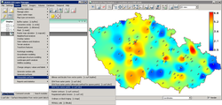
 GRASS graphical user interface | |
| 開発元 | GRASS Development Team |
|---|---|
| 初版 | 1984年 |
| 最新版 |
8.3.2[1] |
| リポジトリ | |
| プログラミング 言語 | |
| 対応OS | クロスプラットフォーム |
| 対応言語 | |
| サポート状況 | 開発中 |
| 種別 | 地理情報システム |
| ライセンス | GNU General Public License |
| 公式サイト |
grass |
GRASS GIS︵正式名称‥Geographic Resources Analysis Support System Geographical Information System︶は、ラスターイメージや位相空間ベクトル、画像処理などを行うフリーのオープンソースGISソフトウェアである[2]。
GNU General Public Licenseで提供されており、Mac OS XやMicrosoft Windows、Linuxを含むプラットフォームに対応している。また、GUIを通じてQGIS等の他のソフトウェアに接続し利用することができる。
Ver 6においてベクトルネットワーク解析機能や2D/3Dの位相空間エンジンの新機能が追加された。MySQLやPostgreSQL、PostGIS、SQLiteなどのデータベースファイルか、DBASEファイルによりデータが管理される。これにより3Dのベクタ形式やボクセルの量が視覚化可能になった。他のGISソフトウェアとの相互運用性があるGDALライブラリの利用により大容量のラスターグラフィックスやベクターフォーマットに対応している。
概要[編集]
ラスターと二三次元のベクトルデータに対応しており、ベクトルデータは地理情報の図心と境界面が明確な位相空間情報により構成されている。 300以上のコアモジュールと100以上のアドオンが公式及び有志により制作されている。コアモジュールとライブラリはCで書かれており、その他モジュールはCやC++、Python、UNIX shell、Tclなどのプログラミング言語で書かれている。これらモジュールはUNIX哲学に基づき、Cプログラミングの知識のないユーザーによりシェルスクリプトとモジュールを組み合わせ制作されている。 Ver 6.4においてPythonのコードとwxPythonの画像ライブラリを用いたwxGUIと呼ばれるGUIが採用された。 QGISと連携しており、Quantum GISの最新版ではGRASSの動作環境を利用することで、シェルベースのGRASSのインターフェースよりも利用しやすいGUIにてGRASSが操作できる。QGISの最新版では、インストールと同時に組み込まれている。 Javaで実装したJGRASSというプロジェクトが存在する。脚注[編集]
- ^ "Release 8.3.2"; 閲覧日: 2024年3月22日; 出版日: 2024年3月7日.
- ^ Neteler, M.; Mitasova, H. (2008). Open Source GIS: A GRASS GIS Approach (3rd ed.). New York: Springer. ISBN 978-0-387-35767-6
