出典: フリー百科事典『ウィキペディア(Wikipedia)』
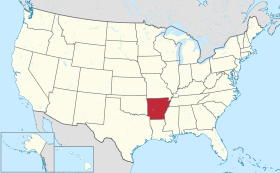
アーカンソー州
State of Arkansas
州の愛称 : 自然の州
州名の由来 [ 編集 ]
﹁ ア ー カ ン ソ ー ﹂ と い う 名 前 は カ ン ザ ス 州 と 語 源 を 同 じ く す る 。 カ ン ザ 族 ( コ ー 族 ) イ ン デ ィ ア ン は グ レ ー ト プ レ ー ン ズ の ス ー 族 と 密 接 な 関 係 が あ る 。 カ ン ザ 族 と 近 縁 の ク ア ポ ー 族 ( Q u a p a w ) の 言 葉 で ﹁ 下 流 の 人 々 の 土 地 ﹂ を 意 味 す る ﹁ ア カ カ ズ ﹂ ︵ a k a k a z e ︶ 、 あ る い は ス ー 族 の 言 葉 で ﹁ 南 風 の 人 々 ﹂ を 意 味 す る ﹁ ア カ カ ズ ﹂ ︵ a k a k a z e ︶ を フ ラ ン ス 語 風 に 発 音 し た の が ア ー カ ン ソ ー ︵ " A r c a n s a s " ︶ で あ る 。 な お 、 こ の 語 末 の ﹁ a + 子 音 字 ﹂ は 標 準 フ ラ ン ス 語 で は [ a ] と 発 音 す る た め 、 こ れ を [ ɔ ː ] と 発 音 す る の は ケ ベ ッ ク ・ フ ラ ン ス 語 な ど 北 ア メ リ カ の フ ラ ン ス 語 の 特 徴 と い え る 。 ア ー カ ン ソ ー の 発 音 に つ い て は 、 州 選 出 の 2 人 の ア メ リ カ 合 衆 国 上 院 議 員 の 間 で 、 片 方 が ﹁ ア ー カ ン ザ ス ﹂ ︵ a r - K A N - z ə s ︶ を 主 張 し た の に 対 し 、 も う 一 方 が ﹁ ア ー カ ン ソ ー ﹂ ︵ AR - k ə n - s a w ︶ を 主 張 す る と い う 論 争 が あ っ た ︵ 太 字 に 第 一 強 勢 ア ク セ ン ト ︶ [ 注 釈 1 ] 。 そ し て 1 8 8 1 年 の 州 議 会 立 法 で 公 式 に ﹁ ア ー カ ン ソ ー ﹂ と 決 め ら れ た 。
開 拓 初 期 に ク マ が 多 く 棲 息 し て い た た め ﹁ ク マ の 州 B e a r S t a t e ﹂ と い う 愛 称 が あ る 。 [ 4 ]
ア ー カ ン ソ ー 州 と な っ た 地 域 を 最 初 に 訪 れ た ヨ ー ロ ッ パ 人 は 、 フ ラ ン シ ス コ ・ ピ サ ロ が ペ ル ー を 征 服 し た 時 の 軍 人 で あ る ス ペ イ ン 人 探 検 家 エ ル ナ ン ド ・ デ ・ ソ ト で あ り 、 金 と 中 国 へ の 道 を 探 し て ほ ぼ 1 年 間 ア ー カ ン ソ ー 南 部 を 探 索 し た 後 、 1 5 4 2 年 に ミ シ シ ッ ピ 川 沿 い の 現 在 の ( レ イ ク ビ レ ッ ジ ) 近 く で 死 ん だ 。 ス ペ イ ン 人 あ る い は フ ラ ン ス 人 の 探 検 家 が 、 ミ シ シ ッ ピ 川 の 下 流 に 住 ん で い た ク ア ポ ー 族 イ ン デ ィ ア ン を イ リ ノ イ 族 ( I l l i n o i s C o n f e d e r a t i o n ) が 呼 ん で い た 言 葉 か ら 音 を 借 り て 、 ア ー カ ン ソ ー と い う 名 前 を 付 け た [ 5 ] 。 ア ー カ ン ソ ー 地 域 に 住 ん で い た イ ン デ ィ ア ン 部 族 と し て は 、 ク ア ポ ー 族 、 カ ド 族 、 オ ー セ ー ジ 族 ( O s a g e N a t i o n ) な ど が い た 。 彼 等 が 西 方 に 強 制 移 住 さ せ ら れ た 後 は 、 文 明 化 五 部 族 が 入 っ て き た 。
ア ー カ ン ソ ー は 、 1 8 0 3 年 に ア メ リ カ 合 衆 国 が ナ ポ レ オ ン ・ ボ ナ パ ル ト か ら 買 収 し た ル イ ジ ア ナ 領 土 の 一 部 だ っ た 。 1 8 1 9 年 7 月 4 日 に ア ー カ ン ソ ー 準 州 と な り 、 1 8 3 6 年 に 合 衆 国 25 番 目 の 州 、 13 番 目 の 奴 隷 州 と し て 州 昇 格 を 認 め ら れ た 。 農 園 経 営 者 が ア ー カ ン ソ ー ・ デ ル タ に 入 っ て 綿 花 を 栽 培 し 、 ア フ リ カ 人 奴 隷 が 最 も 多 い 地 域 と な っ た 。 他 の 地 域 は 自 作 農 が 多 く 、 作 物 も 多 種 に わ た っ た 。
ア ー カ ン ソ ー は 、 テ キ サ ス が メ キ シ コ か ら の 独 立 を 果 た し た 戦 争 で 、 部 隊 や 物 資 を 送 っ て 重 要 な 役 割 を 果 た し た 。 州 内 ( ワ シ ン ト ン 市 ) は テ キ サ ス 国 境 に 近 く 、 1 8 3 5 年 か ら 1 8 3 6 年 の テ キ サ ス 革 命 に 巻 き 込 ま れ た 。 1 8 3 4 年 に サ ミ ュ エ ル ・ ヒ ュ ー ス ト ン や そ の 同 調 者 が 、 ワ シ ン ト ン 市 の 酒 場 で 革 命 の 計 画 を 練 っ た と い う 証 拠 も あ る 。 戦 争 が 始 ま る と 、 ア ー カ ン ソ ー 州 な ど 南 東 部 州 の 志 願 兵 が こ の 町 を 通 っ て テ キ サ ス の 戦 場 に 向 か っ た 。
1 8 4 6 年 に 米 墨 戦 争 が 始 ま る と 、 ワ シ ン ト ン は 志 願 兵 の 集 合 地 点 に な っ た 。 州 知 事 の ト マ ス ・ S ・ ド ル ー ( T h o m a s S t e v e n s o n D r e w ) は 州 内 で 騎 兵 1 個 連 隊 と 砲 兵 1 個 大 隊 を 立 ち 上 げ 、 ア メ リ カ 陸 軍 に 加 え る と い う 声 明 を 発 し た 。 10 個 中 隊 が 纏 め ら れ 、 ア ー カ ン ソ ー 騎 兵 第 1 連 隊 に 繰 り 入 れ ら れ た 。
ミ シ シ ッ ピ ・ デ ル タ の 東 部 で は 綿 花 文 化 が 発 展 し 、 農 園 主 が 連 れ て く る か 、 ア ッ パ ー サ ウ ス の 諸 州 か ら 輸 入 し た 奴 隷 を 大 々 的 に 使 っ て い た 。 南 北 戦 争 開 戦 前 の 1 8 6 0 年 、 州 内 に は 1 1 1 , 1 1 5 人 の 奴 隷 が お り 、 州 人 口 の 2 5 % を 超 え て い た [ 6 ] 。
1 8 6 1 年 初 期 、 湾 岸 の 州 は 揃 っ て 合 衆 国 か ら 脱 退 し た が 、 ア ー カ ン ソ ー 州 が 脱 退 し た の は 、 サ ム タ ー 要 塞 の 戦 い に 続 い て エ イ ブ ラ ハ ム ・ リ ン カ ー ン 大 統 領 が 軍 隊 招 集 を 呼 び か け た 後 に な っ て か ら 、 1 8 6 1 年 5 月 6 日 だ っ た 。 大 規 模 会 戦 が 続 い た 東 部 戦 線 と は 異 な り 、 ア ー カ ン ソ ー 州 内 で は 多 く の 小 競 り 合 い や 小 規 模 戦 闘 が あ っ た 。 当 時 注 目 さ れ た の は 南 軍 の パ ト リ ッ ク ・ ク リ バ ー ン 少 将 だ っ た 。 多 く の 者 が 南 軍 師 団 長 の 中 で も 最 も 傑 出 し た 将 軍 と 見 な し 、 ﹁ 西 の ス ト ー ン ウ ォ ー ル ﹂ と 呼 ば れ る こ と も 多 か っ た 。 元 連 邦 議 会 議 員 だ っ た ト マ ス ・ ハ イ ン ド マ ン 少 将 が 、 州 北 西 部 で 起 き た ケ イ ン ヒ ル の 戦 い ( B a t t l e o f C a n e H i l l ) と プ レ ー リ ー グ ロ ー ブ の 戦 い で 南 軍 を 指 揮 し た 。
軍 政 の 布 か れ た レ コ ン ス ト ラ ク シ ョ ン 時 代 、 連 邦 議 会 は 1 8 6 8 年 6 月 に ア ー カ ン ソ ー 州 の 連 邦 復 帰 を 宣 言 し た 。 共 和 党 が 支 配 し た 州 議 会 で は 、 男 性 の 普 通 選 挙 ︵ た だ し 南 軍 協 力 者 、 そ の 大 半 は 民 主 党 員 は 選 挙 権 を 剥 奪 さ れ た ︶ や 公 共 教 育 制 度 を 導 入 し 、 州 内 の 問 題 を 解 決 し 人 口 を 増 や す た め の 方 策 を 定 め た 。 州 議 会 は 急 進 派 共 和 党 ︵ 北 部 か ら 入 っ て 来 た 政 治 家 た ち で 、 汚 職 を 噂 さ れ た た め ﹁ カ ー ペ ッ ト バ ッ ガ ー ﹂ と 呼 ば れ た ︶ の 圧 倒 的 支 配 下 に 入 り 、 パ ウ ェ ル ・ ク レ イ ト ン ( P o w e l l C l a y t o n ) 知 事 の 下 で 、 共 和 党 民 兵 と ク ー ・ ク ラ ッ ク ス ・ ク ラ ン と の 間 の 暴 動 と 人 種 間 暴 力 の 時 代 を 過 ご し た 。
1 8 7 4 年 、 2 年 前 の 州 知 事 選 の も つ れ か ら 共 和 党 の 派 閥 間 で の 政 争 で あ る ブ ル ッ ク ス ・ バ ク ス タ ー 戦 争 ( B r o o k s – B a x t e r W a r ) が 起 こ り 、 リ ト ル ロ ッ ク や 州 政 府 を 揺 り 動 か し た 。 こ れ は ユ リ シ ー ズ ・ グ ラ ン ト 大 統 領 が 州 知 事 候 補 の 一 人 だ っ た ジ ョ セ フ ・ ブ ル ッ ク ス ( J o s e p h B r o o k s ( p o l i t i c i a n ) ) に そ の 軍 事 的 支 持 者 を 解 散 さ せ る よ う 命 じ て や っ と 解 決 さ れ た [ 7 ] 。 そ の 後 新 州 憲 法 が 批 准 さ れ 、 元 南 軍 協 力 者 の 選 挙 権 が 回 復 さ れ た 。
1 8 8 1 年 の 州 議 会 立 法 で 公 式 に ﹁ ア ー カ ン ソ ー ﹂ と い う 発 音 が 決 定 さ れ 、 続 い て い た 州 名 の 発 音 に ま つ わ る 論 争 に ケ リ を 付 け た 。
レ コ ン ス ト ラ ク シ ョ ン 後 、 州 内 に は 国 内 外 か ら の 移 民 が 増 加 す る よ う に な っ た 。 中 国 人 、 イ タ リ ア 人 、 シ リ ア 人 な ど が 発 展 す る デ ル タ 地 帯 の 農 場 労 働 力 と し て 導 入 さ れ た 。 し か し 長 く 農 場 労 働 者 と し て 留 ま る 者 は い な か っ た 。 特 に 中 国 人 は 直 ぐ に デ ル タ 周 辺 の 町 の 小 商 人 に な っ た 。 20 世 紀 初 期 に 入 っ て き た の は 東 ヨ ー ロ ッ パ か ら の 移 民 が い た 。 デ ル タ 周 辺 は 他 の 地 域 よ り も 民 族 分 布 的 に 多 様 に な っ た 。 同 じ こ ろ に 黒 人 の 移 民 も 入 っ て き て お り 、 低 湿 地 を 開 発 し 自 ら の 資 産 を 持 つ 機 会 を 得 よ う と し て い た 。 多 く の 中 国 人 は 小 さ な 町 の 商 人 と し て 成 功 し 、 そ の 子 弟 を 大 学 で 学 ば せ る よ う に な っ た [ 8 ] 。
小 作 農 の 妻 と 子 供 達 、 ワ シ ン ト ン 郡 、 1 9 3 5 年 ご ろ 鉄 道 の 開 通 は 、 よ り 多 く の 農 民 が 作 物 を 市 場 に 送 る こ と を 可 能 に し た 。 ま た リ ゾ ー ト 地 と し て 開 発 さ れ た オ ザ ー ク 高 原 な ど 、 農 村 地 帯 以 外 の 発 展 に も つ な が っ た 。 例 え ば 、 19 世 紀 の 末 ご ろ 、 キ ャ ロ ル 郡 の ユ リ ー カ ス プ リ ン グ ス は 急 速 に 観 光 地 と し て 成 長 し 、 人 口 1 万 人 と 州 内 第 4 の 都 市 と な っ た 。 健 康 に 良 い と 考 え ら れ た 天 然 泉 周 辺 に 優 美 な リ ゾ ー ト ホ テ ル や 温 泉 が 新 築 さ れ た 。 こ の 町 の 呼 び 物 に は 競 馬 な ど 娯 楽 も あ っ た 。 こ の 町 は 様 々 な 階 層 に 受 け 、 州 内 ホ ッ ト ス プ リ ン グ ス と 同 じ く ら い の 人 気 が 出 た 。
1 8 8 0 年 代 後 半 、 農 業 の 景 気 が 悪 化 し て ポ ピ ュ リ ス ト な ど 第 三 政 党 が 生 ま れ 、 異 人 種 間 の 連 衡 に 繋 が っ た 。 南 部 の 他 州 と 同 様 、 民 主 党 は 権 力 を 保 持 す る た め に 議 会 立 法 や 憲 法 の 修 正 を 行 い 、 黒 人 や 白 人 低 所 得 層 の 選 挙 権 を 剥 奪 し た 。 民 主 党 は 彼 等 の 連 携 を 阻 止 し よ う と し た 。 1 8 9 1 年 、 黒 人 や 白 人 低 所 得 層 が 排 除 さ れ る こ と を 期 待 し て 、 議 会 は 識 字 能 力 テ ス ト を 求 め る 法 を 成 立 さ せ た 。 こ の こ ろ 人 口 の 2 5 % 以 上 が 読 み 書 き で き な か っ た 。 1 8 9 2 年 、 州 憲 法 を 改 正 し て 、 有 権 者 登 録 税 と さ ら に 複 雑 な 住 民 資 格 を 定 め 、 貧 民 や 小 作 農 な ど を 選 挙 か ら 閉 め 出 し た 。
1 9 0 0 年 、 民 主 党 は 郡 と 州 の 選 挙 で 白 人 予 備 選 挙 ( W h i t e p r i m a r i e s ) を 拡 大 し 、 黒 人 が 政 治 に 関 わ る こ と を 否 定 し た 。 予 備 選 挙 で 黒 人 が 候 補 者 に な れ た と し て も 、 民 主 党 が 権 力 の 全 て を 掌 握 し た 。 数 十 年 間 も 民 主 党 一 党 独 裁 が 継 続 し た が 、 1 9 6 4 年 の 公 民 権 法 と 1 9 6 5 年 の 選 挙 権 法 成 立 で 、 そ の 時 代 が 終 わ っ た 。
1 9 0 5 年 か ら 1 9 1 1 年 に か け て 、 ド イ ツ 人 、 ス ロ バ キ ア 人 、 ア イ ル ラ ン ド 人 移 民 が 少 数 な が ら 入 っ て く る よ う に な っ た 。 ド イ ツ 人 と ス ロ バ キ ア 人 は プ レ ー リ ー と 呼 ば れ た 州 東 部 に 入 り 、 ア イ ル ラ ン ド 人 移 民 は 南 東 部 に 小 さ な 地 域 社 会 を 作 っ た 。 ド イ ツ 人 は 大 半 が ル ー テ ル 教 会 員 で あ り 、 ス ロ バ キ ア 人 は カ ト リ ッ ク 教 徒 だ っ た 。 ア イ ル ラ ン ド 人 は ア ル ス タ ー の プ ロ テ ス タ ン ト が 多 か っ た 。
1 9 5 4 年 、 ﹁ ブ ラ ウ ン 対 ト ピ カ 教 育 委 員 会 事 件 ﹂ に 対 す る ア メ リ カ 合 衆 国 最 高 裁 判 所 判 決 が 出 た 後 、 州 都 リ ト ル ロ ッ ク で 高 校 で の 人 種 差 別 撤 廃 を 求 め た ア フ リ カ 系 ア メ リ カ 人 生 徒 を 保 護 す る た め に 連 邦 政 府 が 干 渉 し た 、 い わ ゆ る リ ト ル ロ ッ ク ・ ナ イ ン が 全 国 の 注 目 を 集 め さ せ た 。 オ ー バ ル ・ フ ォ ー バ ス 州 知 事 は 州 軍 に 命 じ て 、 9 人 の ア フ リ カ 系 ア メ リ カ 人 生 徒 が リ ト ル ロ ッ ク 中 央 高 校 に 入 る の を 阻 止 す る 人 種 分 離 主 義 者 を 助 け る よ う 仕 向 け た 。 ド ワ イ ト ・ D ・ ア イ ゼ ン ハ ワ ー 大 統 領 は フ ォ ー バ ス 州 知 事 と 3 度 接 触 を 試 み た 後 、 現 役 任 務 の 第 1 0 1 空 挺 師 団 か ら 1 , 0 0 0 名 を 派 遣 し て 、 9 人 の 生 徒 が 1 9 5 7 年 9 月 25 日 に 高 校 に 入 学 す る の を 護 衛 す る よ う 命 じ た 。 合 衆 国 裁 判 所 が 人 種 統 合 を 行 う よ う 命 令 を 出 し た こ と に 対 抗 し て 、 知 事 と リ ト ル ロ ッ ク 市 は 、 そ の 学 校 年 の 残 り 期 間 高 校 を 閉 鎖 す る こ と を 決 め た 。 1 9 5 9 年 秋 ま で に リ ト ル ロ ッ ク 市 の 高 校 は 完 全 に 人 種 差 別 を 撤 廃 し た [ 9 ] ︵ リ ト ル ロ ッ ク 高 校 事 件 ︶ 。
1 9 9 2 年 、 民 主 党 の ビ ル ・ ク リ ン ト ン が こ の 州 出 身 者 と し て 初 め て 大 統 領 に 選 出 さ れ た 。 ク リ ン ト ン は 州 内 ホ ー プ 市 の 生 ま れ で あ り 、 第 40 代 お よ び 第 42 代 州 知 事 を 合 計 12 年 間 務 め て い た 。
参 照 ‥ ア ー カ ン ソ ー 州 の 郡 一 覧 プ テ ィ ジ ャ ン 州 立 公 園 の プ テ ィ ジ ャ ン 山 か ら の 眺 め マ ギ ー ヒ ー 近 く ア ー カ ン ソ ー ・ デ ル タ の 平 坦 な 地 形 ワ シ タ 国 有 林 を 流 れ る ワ シ タ 川 ス ト ー ン 郡 に あ る ブ ラ ン チ ャ ー ド ・ ス プ リ ン グ ス 洞 窟 バ ッ フ ァ ロ ー 国 立 河 川 ワ シ タ 山 地 の フ ラ ッ ト サ イ ド 原 生 地 州 の 北 は ミ ズ ー リ 州 に 接 し 、 東 は テ ネ シ ー 州 と ミ シ シ ッ ピ 州 に 、 西 は オ ク ラ ホ マ 州 と テ キ サ ス 州 に 、 南 は ル イ ジ ア ナ 州 に 接 し て い る 。 ア メ リ カ 合 衆 国 国 勢 調 査 局 は ア ー カ ン ソ ー 州 を ア メ リ カ 合 衆 国 南 部 に 分 類 し 、 さ ら に 西 南 中 央 部 州 に 小 分 類 し て い る [ 1 ] 。 ミ シ シ ッ ピ 川 が 州 東 部 境 界 の 大 半 を 構 成 し て い る が 、 北 東 部 に あ る ク レ イ 郡 と グ リ ー ン 郡 あ る 部 分 は 、 ミ ズ ー リ 州 南 東 部 の 靴 の 踵 状 に 伸 び た 部 分 ( B o o t h e e l ) が あ り 、 セ ン ト フ ラ ン シ ス 川 が 州 境 に な っ て い る 。 ま た 州 境 が 法 律 で 決 め ら れ て 以 降 、 ミ シ シ ッ ピ 川 が 流 れ を 変 え た 場 所 が 多 く あ る 。 こ の た め に 東 の ミ シ シ ッ ピ 州 と の 境 界 は 確 定 で き な い 要 素 が あ る [ 1 0 ] 。
ア ー カ ン ソ ー 州 の 地 形 を 見 る と 、 北 西 部 の 高 地 と 南 東 部 の 低 地 に 二 分 で き る [ 1 1 ] 。 北 西 部 高 地 は 南 部 内 陸 高 原 の 一 部 で あ り 、 オ ザ ー ク 高 原 や ワ シ タ 山 地 が あ る 。 南 東 部 低 地 に は メ キ シ コ 湾 海 岸 平 原 と ア ー カ ン ソ ー ・ デ ル タ が 含 ま れ る [ 1 2 ] 。 こ の 2 地 域 に 分 け る や り 方 は 幾 ら か 単 純 化 し 過 ぎ た き ら い が あ り 、 州 を 北 西 部 、 南 西 部 、 北 東 部 、 南 東 部 お よ び 中 央 部 に 分 け る の が 通 常 の 分 類 方 法 で あ る が 、 明 確 な 境 界 が 設 定 さ れ て い る わ け で は な い 。 地 形 で は オ ザ ー ク 高 原 、 ワ シ タ 山 地 、 ア ー カ ン ザ ス 川 河 谷 、 メ キ シ コ 湾 海 岸 平 原 、 ク ロ ウ リ ー ズ リ ッ ジ お よ び ア ー カ ン ソ ー ・ デ ル タ 、 さ ら に は 他 地 域 と 重 な る 州 中 央 部 の 7 つ に 分 類 す る こ と も で き る [ 1 3 ] 。
ミ シ シ ッ ピ 沖 積 平 原 に 沿 っ た 南 東 部 は ア ー カ ン ソ ー ・ デ ル タ と 呼 ば れ る 。 こ の 地 域 は ミ シ シ ッ ピ 川 が 度 々 洪 水 を 起 こ し て 堆 積 さ れ た 肥 沃 な 沖 積 土 壌 に よ っ て 平 坦 で あ る 。 南 東 部 の 川 か ら 離 れ た 地 域 は う ね り の あ る グ ラ ン ド プ レ ー リ ー に な る 。 こ れ ら は ど ち ら も 肥 沃 な 農 業 地 帯 で あ る 。 ア ー カ ン ソ ー ・ デ ル タ は ク ロ ウ リ ー ズ リ ッ ジ と 呼 ば れ る 異 常 な 地 質 層 に よ っ て 二 分 さ れ て い る 。 ク ロ ウ リ ー ズ リ ッ ジ は う ね り の あ る 細 い 幅 の 丘 陵 線 で あ り 、 周 り の 沖 積 平 原 か ら は 2 5 0 な い し 5 0 0 フ ィ ー ト ( 7 5 - 1 5 0 m ) 立 ち 上 が っ て い る 。 州 東 部 の 主 要 な 町 の 多 く が こ の 丘 陵 線 に 沿 っ て あ る [ 1 4 ] 。
州 北 西 部 は オ ザ ー ク 山 地 を 含 む オ ザ ー ク 高 原 の 一 部 で あ り 、 南 に は ワ シ タ 山 地 が あ り 、 ア ー カ ン ザ ス 川 で 二 分 さ れ て い る 。 州 南 部 と 東 部 は 低 地 と 呼 ば れ て い る 。 こ れ ら の 山 地 は ア メ リ カ 内 陸 高 原 の 一 部 で あ り 、 ロ ッ キ ー 山 脈 と ア パ ラ チ ア 山 脈 の 間 で は 唯 一 の 高 原 地 帯 で あ る [ 1 5 ] 。 州 内 最 高 地 点 は ワ シ タ 山 地 に あ る マ ガ ジ ン 山 で あ り 、 標 高 は 2 , 7 5 3 フ ィ ー ト ( 8 3 9 m ) で あ る 。
州 内 お よ び 州 境 に は 多 く の 河 川 、 湖 、 貯 水 池 ︵ 人 造 湖 ︶ が あ る 。 ミ シ シ ッ ピ 川 の 主 要 な 支 流 と し て は 、 ア ー カ ン ザ ス 川 、 ホ ワ イ ト 川 、 セ ン ト フ ラ ン シ ス 川 が あ る 。 ア ー カ ン ザ ス 川 河 谷 で は マ ル ベ リ ー 川 と フ ー シ ュ ラ フ ェ イ 川 が ア ー カ ン ザ ス 川 に 注 ぎ 、 ダ ー ダ ネ ル 湖 も あ る 。 ホ ワ イ ト 川 に は 、 バ ッ フ ァ ロ ー 川 、 リ ト ル レ ッ ド 川 、 ブ ラ ッ ク 川 、 キ ャ ッ シ ュ 川 が 注 い で い る 。 州 南 部 の ワ シ タ 川 に は 、 セ イ リ ー ン 川 、 リ ト ル ミ ズ ー リ 川 、 バ イ ユ ー ・ バ ー ソ ロ ミ ュ ー 、 カ ド ー 川 が 注 い で い る 。 レ ッ ド 川 の 一 部 は テ キ サ ス 州 と の 州 境 に な っ て い る [ 1 6 ] 。 自 然 の 湖 は ほ と ん ど 無 い が 、 ブ ル シ ョ ー ル ズ 湖 、 ワ シ タ 湖 、 グ リ ア ー ズ フ ェ リ ー 湖 、 ミ ル ウ ッ ド 湖 、 ビ ー バ ー 湖 、 ノ ー フ ォ ー ク 湖 、 デ グ レ イ 湖 、 コ ン ウ ェ イ 湖 な ど ダ ム で 造 ら れ た 人 造 湖 は 多 い [ 1 7 ] 。
ア ー カ ン ソ ー 州 に は ブ ラ ン チ ャ ー ド ・ ス プ リ ン グ ス 洞 窟 な ど 、 多 く の 洞 窟 が 存 在 す る 。 州 内 の 考 古 学 者 に よ っ て 、 先 コ ロ ン ブ ス 期 に イ ン デ ィ ア ン が 住 み 、 狩 り を 行 い 、 道 具 を 作 っ た 場 所 、 4 3 , 0 0 0 か 所 以 上 が 登 録 さ れ て い る 。 そ の 多 く は 墳 丘 墓 や 岩 の く ぼ み の 住 居 で あ る 。 州 内 に は ホ ッ ト ス プ リ ン グ ス 国 立 公 園 及 び バ ッ フ ァ ロ ー 国 立 河 川 が あ る 。 ア ー カ ン ソ ー 州 は ダ イ ヤ モ ン ド が 自 然 に 埋 蔵 さ れ て い る 事 が 発 見 さ れ た 合 衆 国 内 で 唯 一 の 州 で あ る 。 た だ し 一 般 人 が 少 な い 日 給 で 原 始 的 な 掘 削 道 具 を 使 っ て 掘 り 出 す も の で あ り 、 商 業 ベ ー ス に は 乗 っ て い な い [ 1 8 ] [ 1 9 ] 。
州 内 に は 多 く の 原 生 林 が あ り 、 そ の 総 面 積 は 15 万 エ ー カ ー ( 6 0 0 km 2 ) ほ ど も あ る 。 ア ウ ト ド ア ・ レ ク リ エ ー シ ョ ン の た め の 地 域 が 指 定 さ れ 、 狩 猟 、 釣 り 、 ハ イ キ ン グ 、 キ ャ ン プ な ど に 開 放 さ れ て い る 。 自 動 車 の 進 入 が 禁 止 さ れ て い る 。
植 物 相 と 動 物 相 [ 編 集 ] 生 態 系 地 域 と し て は 、 ﹁ オ ザ ー ク ・ ワ シ タ ・ ア パ ラ チ ア 森 林 地 域 ﹂ 、 ﹁ ミ シ シ ッ ピ 沖 積 平 原 ・ 南 東 部 海 岸 平 原 ﹂ 、 ﹁ 南 東 部 平 原 ﹂ の 3 つ に 分 け ら れ て い る [ 2 0 ] 。 さ ら に ア ー カ ン ザ ス ・ バ レ ー 、 ボ ス ト ン 山 地 、 ミ シ シ ッ ピ 沖 積 平 原 、 ミ シ シ ッ ピ ・ バ レ ー 黄 土 平 原 、 オ ザ ー ク 高 原 、 ワ シ タ 山 地 、 南 中 部 平 原 の 7 つ に 小 区 分 さ れ て い る [ 2 1 ] 。 ア メ リ カ 合 衆 国 森 林 局 に よ る 2 0 1 0 年 調 査 に よ り 、 州 総 面 積 の 5 6 % 、 1 , 8 7 2 万 エ ー カ ー ( 7 5 , 0 0 0 k m 2 ) が 森 林 地 と さ れ た [ 2 2 ] 。 こ の 森 林 地 に 多 い 樹 種 は 、 オ ー ク 、 ヒ ッ コ リ ー ( C a r y a ) 、 短 葉 松 ( P i n u s e c h i n a t a ) 、 テ ー ダ マ ツ で あ る [ 2 3 ] [ 2 4 ] 。 オ ザ ー ク 高 原 や ワ シ タ 山 地 は 氷 河 期 に 氷 河 に 覆 わ れ な か っ た こ と か ら 、 固 有 種 の 動 植 物 が 比 較 的 多 い [ 2 5 ] 。
絶 滅 危 惧 種 ハ シ ジ ロ キ ツ ツ キ が 州 内 に 生 息 し て い る 可 能 性 が コ ー ネ ル 大 学 の 鳥 類 学 チ ー ム に よ っ て 発 表 さ れ て い る [ 2 6 ] 。
ア ー カ ン ソ ー 州 は 温 暖 湿 潤 気 候 ︵ ケ ッ ペ ン の 気 候 区 分 C f a ︶ に あ り 、 北 部 山 岳 地 で は 湿 潤 大 陸 性 気 候 で あ る 。 メ キ シ コ 湾 に 接 し て は い な い が 、 そ の 暖 か く 巨 大 な 水 域 に 近 い の で 、 州 内 の 気 候 に 影 響 を 受 け て い る 。 概 し て 暑 く 湿 潤 な 夏 と 、 冷 た く や や 乾 燥 し た 冬 が 特 徴 で あ る 。 リ ト ル ロ ッ ク の 7 月 で は 、 日 中 の 平 均 最 高 気 温 が 93 ° F ( 34 ℃ ) 、 最 低 気 温 は 73 ° F ( 23 ℃ ) と な る 。 1 月 で は 、 平 均 最 高 気 温 が 51 ° F ( 11 ℃ ) 、 最 低 気 温 が 32 ° F ( 0 ℃ ) と な る 。 州 北 西 部 の サ イ ロ ー ム ス プ リ ン グ ス の 7 月 で は 、 日 中 の 平 均 最 高 気 温 が 89 ° F ( 32 ℃ ) 、 最 低 気 温 は 67 ° F ( 19 ℃ ) と な る 。 1 月 で は 、 平 均 最 高 気 温 が 44 ° F ( 7 ℃ ) 、 最 低 気 温 が 23 ° F ( - 5 ℃ ) と な る 。 年 間 平 均 降 水 量 は 40 な い し 60 イ ン チ ( 1 , 0 0 0 - 1 , 5 0 0 m m ) で あ る 。 南 部 で 降 水 量 が 多 く 、 北 部 は 少 な い 。 降 雪 は 北 部 で 多 く 、 年 間 数 回 雪 が 降 る こ と が あ る 。 こ れ に は 平 原 州 に 接 し て い る こ と だ け で な く 、 オ ザ ー ク 高 原 や ワ シ タ 山 地 な ど 標 高 が 高 い こ と も 関 係 し て い る 。 リ ト ル ロ ッ ク よ り 南 部 で は 雪 が 少 な い が 、 氷 雨 を 伴 う 暴 風 に 襲 わ れ る こ と が あ る 。 冬 季 の み ぞ れ な ど 凍 る よ う な 雨 は 州 全 体 で 見 ら れ 、 交 通 や 日 々 の 暮 ら し に 影 響 し て い る 。 州 内 過 去 最 高 気 温 は 1 9 3 6 年 8 月 10 日 に オ ザ ー ク で 記 録 さ れ た 1 2 0 ° F ( 49 ℃ ) 、 過 去 最 低 気 温 は 1 9 0 5 年 2 月 13 日 に ラ ウ ン ド ポ ン ド で 記 録 さ れ た - 2 9 ° F ( - 3 4 ℃ ) で あ る 。
異 常 気 象 で も 知 ら れ て い る 。 通 常 年 に は 雷 雨 、 竜 巻 、 雹 、 雪 、 氷 雨 が み ら れ る 。 グ レ ー ト プ レ ー ン ズ と メ キ シ コ 湾 岸 の 間 に あ り 、 雷 雨 は 年 間 60 日 ほ ど 記 録 さ れ て い る 。 ア メ リ カ 史 の 中 で も 最 大 級 の 竜 巻 に 襲 わ れ た こ と も あ る 。 海 岸 か ら 離 れ て い る の で ハ リ ケ ー ン に 直 撃 さ れ る こ と は 少 な い が 、 熱 帯 低 気 圧 の 名 残 に よ っ て 短 時 間 に 多 量 の 雨 が 降 っ た り 、 小 さ な 竜 巻 を 生 む こ と も あ る 。
都市
1月
2月
3月
4月
5月
6月
7月
8月
9月
10月
11月
12月
Avg
フェイエットビル [27] 44/24
51/29
59/38
69/46
76/55
84/64
89/69
89/67
81/59
70/47
57/37
48/28
68/47
ジョーンズボロ [28] 45/26
51/30
61/40
71/49
80/58
88/67
92/71
91/69
84/61
74/49
60/39
49/30
71/49
リトルロック [29] 51/31
55/35
64/43
73/51
81/61
89/69
93/73
93/72
86/65
75/53
63/42
52/34
73/51
テクサーカナ [30] 53/31
58/34
67/42
75/50
82/60
89/68
93/72
93/71
86/64
76/52
64/41
55/33
74/52
モンティチェロ [31] 52/30
58/34
66/43
74/49
82/59
89/66
92/70
92/68
86/62
76/50
64/41
55/34
74/51
平均最高 °F/平均最低 °F (平均最高 °C/平均最低°C)
人口動態 [ 編集 ] 人口密度図
人口推移
年
人口
%±
1810 1,062 —
1820 14,273 1,244.0% 1830 30,388 112.9% 1840 97,574 221.1% 1850 209,897 115.1% 1860 435,450 107.5% 1870 484,471 11.3% 1880 802,525 65.6% 1890 1,128,211 40.6% 1900 1,311,564 16.3% 1910 1,574,449 20.0% 1920 1,752,204 11.3% 1930 1,854,482 5.8% 1940 1,949,387 5.1% 1950 1,909,511 −2.0% 1960 1,786,272 −6.5% 1970 1,923,295 7.7% 1980 2,286,435 18.9% 1990 2,350,725 2.8% 2000 2,673,400 13.7% 2010 2,915,918 9.1% 2020 3,011,524 3.3% Source:1910-2010[32]
2 0 2 0 年 国 勢 調 査 時 点 で の ア ー カ ン ソ ー 州 の 人 口 は 3 , 0 1 1 , 5 2 4 人 で 、 2 0 1 0 年 よ り 9 5 , 6 0 6 人 、 す な わ ち 3 . 2 8 % 増 加 し た [ 3 3 ] 。
ア ー カ ン ソ ー 州 の 人 口 は 1 8 2 0 年 で 1 5 , 0 0 0 人 に 満 た な か っ た が 、 1 8 3 5 年 の 特 別 国 政 調 査 時 に 5 2 , 2 4 0 人 に ま で 増 加 し 、 州 昇 格 に 必 要 と さ れ た 4 万 人 を 遙 か に 超 え て い た [ 3 4 ] 。 1 8 3 6 年 に 州 昇 格 を 果 た し た 後 、 1 8 7 0 年 ま で 人 口 は 倍 増 を 続 け た 。 そ の 後 も 成 長 を 続 け た が 1 9 5 0 年 と 1 9 6 0 年 に は 幾 ら か の 減 少 を 記 録 し た 。 こ れ に は 幾 つ か の 原 因 が あ っ た 。 農 業 の 機 械 化 に よ っ て 農 業 労 働 者 の 需 要 が 減 っ た こ と 、 教 育 を 受 け た 若 者 が 農 業 以 外 の 仕 事 を 求 め て 州 を 離 れ た こ と な ど だ っ た [ 3 5 ] 。 そ の 後 は 成 長 を 再 開 し 、 1 9 8 0 年 に は 2 0 0 万 人 を 超 え た [ 3 6 ] 。 現 在 の 成 長 率 、 年 齢 別 構 成 、 男 女 比 率 は 全 国 平 均 と 同 じ 水 準 に あ る 。 少 数 民 族 比 率 も ほ ぼ 全 国 平 均 並 み だ が 、 ヒ ス パ ニ ッ ク 系 の 構 成 比 率 は 全 国 平 均 よ り 約 10 ポ イ ン ト 低 い [ 3 7 ] 。
ア ー カ ン ソ ー 州 の 人 口 重 心 は ペ リ ー 郡 の 北 東 角 と な っ て い る [ 3 8 ] 。
人 種 及 び 祖 先 [ 編 集 ] 州 北 西 部 の オ ザ ー ク や 中 央 部 で は 、 圧 倒 的 に ヨ ー ロ ッ パ 系 ア メ リ カ 人 が 多 い 。 ミ ズ ー リ 州 と の 州 境 に 近 い 最 北 西 部 オ ザ ー ク で は 、 ド イ ツ 系 、 ア イ ル ラ ン ド 系 、 イ ン グ ラ ン ド 系 が 多 い 。 ア イ ル ラ ン ド 系 は 主 に 、 北 ア イ ル ラ ン ド 、 ス コ ッ ト ラ ン ド 低 地 、 お よ び 北 イ ン グ ラ ン ド か ら 来 た ス コ ッ ト ラ ン ド 系 ア イ ル ラ ン ド 人 プ ロ テ ス タ ン ト で あ り 、 ア メ リ カ 独 立 前 に 渡 っ て き た 者 達 の 子 孫 で あ る 。 イ ン グ ラ ン ド 系 と ス コ ッ ト ラ ン ド 系 ア イ ル ラ ン ド 人 移 民 は ア メ リ カ 南 部 の 田 園 部 や 山 岳 地 に 入 植 し た 。 イ ギ リ ス 系 ア メ リ カ 人 は 州 内 全 域 で 見 ら れ る [ 3 9 ] 。 ア フ リ カ 系 ア メ リ カ 人 は 主 に 南 部 と 東 部 に 住 ん で い る 。
人 種 的 な 構 成 比 は 以 下 の 通 り で あ る [ 4 0 ] 。
● 8 0 . 1 % ヒ ス パ ニ ッ ク 含 む 白 人 ︵ 7 4 . 2 % ヒ ス パ ニ ッ ク を 除 く ︶ ● 1 5 . 6 % 黒 人 ● 6 . 6 % ヒ ス パ ニ ッ ク ● 1 . 3 % ア ジ ア ● 0 . 9 % イ ン デ ィ ア ン ● 1 . 8 % 混 血 2 0 1 0 年 に 調 査 さ れ た 祖 先 に よ る 分 類 は 次 の よ う に な っ て い る [ 4 1 ] 。
● 2 0 . 7 % イ ギ リ ス 系 ● 1 5 . 6 % ア フ リ カ 系 ア メ リ カ 人 ● 1 2 . 5 % ア イ ル ラ ン ド 系 ● 1 1 . 2 % ド イ ツ 系 ● 2 . 1 % フ ラ ン ス 系 ● 1 . 7 % オ ラ ン ダ 系 ● 1 . 6 % イ タ リ ア 系 ● 1 . 6 % ス コ ッ ト ラ ン ド 系 ● 1 . 3 % ス コ ッ ト ラ ン ド ・ ア イ ル ラ ン ド 系 ア メ リ カ 人 の 祖 先 を 持 つ と 申 告 し て い る 者 の 多 く は 、 実 際 に は イ ギ リ ス 系 が 多 く 、 幾 ら か は ス コ ッ ト ラ ン ド ・ ア イ ル ラ ン ド 系 で あ る が 、 多 く の 場 合 州 昇 格 以 前 か ら 州 内 に 住 ん で お り 、 単 純 に ア メ リ カ 人 と 申 告 す る か 、 自 身 の 祖 先 を 知 ら な い か で あ る 。 そ の 祖 先 は 13 植 民 地 時 代 に 遡 り 、 そ の た め に ア メ リ カ 人 を 申 告 し て い る 。 ア イ ル ラ ン ド 系 を 申 告 す る 者 の 多 く は ス コ ッ ト ラ ン ド ・ ア イ ル ラ ン ド 系 で あ る [ 4 2 ] [ 4 3 ] [ 4 4 ] [ 4 5 ] 。
2 0 0 0 年 現 在 、 5 歳 以 上 の ア ー カ ン ソ ー 州 民 の 9 3 . 8 % は 自 宅 で 英 語 を 話 し 、 4 . 5 % は ス ペ イ ン 語 を 話 し て い る 。 0 . 7 % が そ の 他 の イ ン ド ・ ヨ ー ロ ッ パ 語 を 話 し 、 0 . 8 % が ア ジ ア 系 言 語 、 そ の 他 が 0 . 2 % で あ る 。
多 く の 他 の 南 部 州 と 同 じ く 、 ア ー カ ン ソ ー 州 は キ リ ス ト 教 プ ロ テ ス タ ン ト が 多 数 を 占 め る 。 住 民 の 宗 教 的 関 係 は 以 下 の よ う に な る ‥
● キ リ ス ト 教 – 8 6 %
● プ ロ テ ス タ ン ト – 7 8 %
● バ プ テ ス ト – 3 9 % ● メ ソ ジ ス ト – 9 % ● ペ ン テ コ ス テ 運 動 – 6 % ● キ リ ス ト 連 合 教 会 – 6 % ● ア ッ セ ン ブ リ ー ズ ・ オ ブ ・ ゴ ッ ド – 3 % ● 他 の プ ロ テ ス タ ン ト – 1 5 % ● ロ ー マ ・ カ ト リ ッ ク – 7 % ● 他 の キ リ ス ト 教 – 1 % ● 他 の 宗 教 – < 1 % ● 無 宗 教 – 1 4 % イ ン デ ィ ア ン 部 族 [ 編 集 ] エ ル ナ ン ド ・ デ ・ ソ ト が 遠 征 し た 16 世 紀 の ア ー カ ン ソ ー 周 辺 の イ ン デ ィ ア ン 集 落
ア ー カ ン ソ ー 州 に 残 る 、 イ ン デ ィ ア ン に よ る 先 史 時 代 の 墳 墓 集 落 遺 跡 ア ー カ ン ソ ー 州 を 通 る ﹁ 国 道 71 号 線 ﹂ は 、 か つ て チ ェ ロ キ ー 族 の オ ク ラ ホ マ 州 へ の 強 制 移 住 ︵ 涙 の 道 ︶ に 使 わ れ た 経 路 で あ る 。
16 世 紀 の カ ス ク ィ 村 の 復 元 図 カ ド ー 族 連 合 、 チ ェ ロ キ ー 族 、 チ カ ソ ー 族 、 チ ョ ク ト ー 族 、 イ リ ニ 族 、 カ ス キ ナ ン ポ 族 、 オ フ ォ 族 、 オ ー セ ー ジ 族 、 ク ア ポ ー 族 、 チ ュ ニ カ 族 、 ヤ ズ ー 族 な ど の イ ン デ ィ ア ン 部 族 が 農 耕 生 活 を 営 み 、 こ と に イ リ ニ 族 や 多 数 の 部 族 が 、 柵 で 囲 ま れ た 土 塁 建 築 に よ る 大 規 模 な 都 市 を 築 い て い た 。 17 ~ 18 世 紀 に 入 る と 、 白 人 入 植 者 に よ っ て 彼 ら の 社 会 は 完 全 に 破 壊 さ れ 、 ほ と ん ど の 部 族 は 滅 ぼ さ れ た 。
州 名 の 由 来 と な っ た ﹁ ア ー カ ン サ ス 族 ︵ ク ア ポ ー 族 ︶ ﹂ を は じ め 、 こ の 州 の イ ン デ ィ ア ン 部 族 の ほ と ん ど は 、 19 世 紀 に 他 州 へ 強 制 移 住 さ せ ら れ た 。 ア メ リ カ 連 邦 政 府 に よ っ て 公 式 に 認 定 さ れ 、 保 留 地 ︵ R e s e r v a t i o n ︶ を 領 有 す る イ ン デ ィ ア ン 部 族 は 一 つ も な い 。
な お も こ の 州 に 先 住 す る イ ン デ ィ ア ン 部 族 は 20 世 紀 に す べ て ﹁ 絶 滅 部 族 ﹂ と し て 認 定 を 取 り 消 さ れ 、 保 留 地 を 没 収 さ れ た 。 現 在 イ ン デ ィ ア ン 部 族 は 、 北 西 部 オ ザ ー ク 及 び こ の 州 の 中 央 部 に 強 力 に 存 在 し 、 ﹁ 復 活 し た ワ シ タ の イ ン デ ィ ア ン ・ ア ー カ ン ソ ー & ア メ リ カ ﹂ を 組 織 し て 部 族 の 再 認 定 と 保 留 地 の 返 還 を 求 め て い る 。
一 方 、 同 州 に 本 部 を 置 く ﹁ ア メ リ カ イ ン デ ィ ア ン の 生 得 権 の 支 援 セ ン タ ー ︵ T h e A m e r i c a n I n d i a n H e r i t a g e S u p p o r t C e n t e r ︶ ﹂ は 、 こ れ ら の 部 族 ・ 団 体 を ﹁ 身 元 の 怪 し い 詐 欺 集 団 ﹂ と 弾 劾 し て い て 、 事 の 正 否 は イ ン デ ィ ア ン に し か わ か ら な い も の と な っ て い る 。 支 援 セ ン タ ー は 、 こ れ ら の 団 体 の 活 動 に 多 数 の 白 人 ブ ロ ー カ ー や ﹁ プ ラ ス チ ッ ク ・ メ デ ィ ス ン マ ン ﹂ ︵ え せ 呪 い 師 ︶ の 介 在 を 指 摘 し 、 営 利 性 の 強 さ を 指 摘 し て い る 。 ア メ リ カ 連 邦 政 府 に 対 す る 、 絶 滅 扱 い さ れ た 非 公 認 イ ン デ ィ ア ン 団 体 の 公 式 認 定 要 求 で 、 資 金 集 め に 名 を 借 り た こ う い っ た ブ ロ ー カ ー の 暗 躍 は 、 イ ン デ ィ ア ン 社 会 で は し ば し ば 指 摘 さ れ て い る 問 題 で あ る 。
ア ー カ ン ソ ー 州 で は 、 州 下 の 学 校 の ク ラ ブ チ ー ム に 、 1 9 3 1 年 か ら オ ー セ ー ジ 族 に 因 ん で ﹁ イ ン デ ィ ア ン ・ マ ス コ ッ ト ﹂ の 応 援 キ ャ ラ ク タ ー が 使 わ れ て き た 。 同 州 は 、 2 0 0 8 年 2 月 28 日 に 、 バ ス ケ ッ ト ボ ー ル の ホ ー ム ゲ ー ム の 終 了 を 以 て 、 こ の ﹁ イ ン デ ィ ア ン ・ マ ス コ ッ ト ﹂ を 公 式 に 廃 止 し た 。 文 化 も 風 俗 も 無 視 し た ス テ レ オ タ イ プ な イ ン デ ィ ア ン の ス ポ ー ツ ・ マ ス コ ッ ト は 、 ﹁ イ ン デ ィ ア ン を お も ち ゃ 扱 い す る 人 種 差 別 で あ る ﹂ と し て 、 全 米 の イ ン デ ィ ア ン 団 体 が 根 絶 廃 止 を 求 め て い る 対 象 の ひ と つ で あ る 。
≪ ア メ リ カ 連 邦 政 府 に 公 式 認 定 を 要 求 中 の イ ン デ ィ ア ン 部 族 と 団 体 ≫
「チェロキー族 」
「アモンスクアース・バンド」
「北チェロキー族」
「北チェロキー族・旧ルイジアナ領土部族」
「北チェロキー族・旧ルイジアナ領土部族・アウィ・アクタ・バンド」
「北チェロキー族・旧ルイジアナ領土部族・アニ・ツィ・ナ・バンド」
「北チェロキー族・ミズーリ&アーサンサス」
「西チェロキー族・アーカンサス・バンド」
「西チェロキー族連邦・アーカンサス」
「アーカンサスとルイジアナ領土の西チェロキー族」
「東チェロキー族・南方バンド・ミズーリ&アーサンサス」
「チカマウガ・チェロキー族」
「チカマウガ・チェロキー族・ホワイトリバー・バンド」
「チカマウガ・チェロキー族・サックリバー&ホワイトリバー・バンド」
「アーカンサス・チェロキー族」
「中央部族会議」
「失われたチェロキー族・ミズーリ&アーサンサス」
「アーカンサス旧移民チェロキー族」
「オザーク山チェロキー族」
「チェロキー族の赤い国家」
「ネチェス・バンド」
「チェロキー・チョクトー族 」
「復活したクアチタ族 」
インディアン・カジノ [ 編集 ]
ア ー カ ン ソ ー 州 で は イ ン デ ィ ア ン 部 族 は 絶 滅 し た こ と に な っ て い る の で 、 部 族 が 運 営 す る ﹁ イ ン デ ィ ア ン ・ カ ジ ノ ﹂ は 現 在 の と こ ろ 一 軒 も な い 。
1 9 8 8 年 に 制 定 さ れ た ﹁ イ ン デ ィ ア ン 賭 博 規 制 法 ﹂ は 、 連 邦 公 認 さ れ て い る イ ン デ ィ ア ン 部 族 に 、 州 政 府 の 管 轄 権 の 及 ば な い 土 地 に 限 っ て カ ジ ノ 設 営 を 認 め る 連 邦 法 で あ る 。 こ の 場 合 の 土 地 は ﹁ R e s e r v a t i o n ︵ 保 留 地 ︶ ﹂ 、 つ ま り 連 邦 か 州 に 認 定 さ れ た 部 族 だ け が 領 有 で き る 土 地 、 ま た は 彼 ら が ﹁ 内 務 省 預 か り ﹂ と し た 土 地 を 言 う 。
隣 州 の オ ク ラ ホ マ 州 に 保 留 地 を 領 有 す る オ ク ラ ホ マ ・ チ ェ ロ キ ー 族 の 主 軸 組 織 ﹁ キ ー ト ゥ ー ワ ー ・ バ ン ド 連 合 ﹂ ( U n i t e d K e e t o o w a h B a n d o f C h e r o k e e I n d i a n s ) は 、 こ の 規 定 に 則 っ て ア ー カ ン ソ ー 州 フ ォ ー ト ス ミ ス に 、 部 族 カ ジ ノ の ﹁ 河 岸 の カ ジ ノ ﹂ を 計 画 、 10 エ ー カ ー ︵ 約 4 万 m 2 ︶ の 土 地 を 連 邦 信 託 の 保 留 地 ︵ R e s e r v a t i o n ︶ と す る 申 請 書 を 提 出 し た 。 こ の 計 画 が 実 現 す れ ば 、 オ ク ラ ホ マ の チ ェ ロ キ ー 族 の カ ジ ノ は ア ー カ ン ソ ー の チ ェ ロ キ ー 族 同 胞 の 雇 用 を 生 む こ と な り 、 彼 ら に 対 し 多 大 な 経 済 的 効 果 が 及 ぶ と み ら れ る 。
2 0 0 8 年 1 月 、 米 国 内 務 省 は こ の キ ー ト ゥ ー ワ ー 連 合 の 申 請 を 却 下 し 、 そ の 理 由 と し て ﹁ 彼 ら の 保 留 地 か ら カ ジ ノ ま で 距 離 が 遠 す ぎ る ﹂ と 説 明 し た 。 こ れ は 全 く の 新 方 針 で あ り 、 キ ー ト ゥ ー ワ ー 連 合 は こ れ を 驚 く べ き 方 針 変 化 と し て い る 。 予 定 地 は オ ク ラ ホ マ の 彼 ら の 保 留 地 か ら 90 マ イ ル ︵ 約 1 4 5 k m ︶ 離 れ て お り 、 19 世 紀 に ア メ リ カ 連 邦 国 家 に よ っ て 強 制 移 住 さ せ ら れ る 前 の 、 彼 ら の 本 来 の 故 郷 に 近 い 地 で あ る 。 こ の 距 離 基 準 に 基 づ き 、 内 務 省 は 他 州 の 10 部 族 か ら 同 州 に 出 さ れ た 同 様 の 申 請 書 を す べ て 却 下 し た 。
主 要 都 市 [ 編 集 ] 参 照 ‥ ア ー カ ン ソ ー 州 の 都 市 圏 の 一 覧 、 e n : L i s t o f c i t i e s i n A r k a n s a s 、 e n : L i s t o f A r k a n s a s t o w n s h i p s . 州 内 に は 、 人 口 2 0 , 0 0 0 人 以 上 の 都 市 が 22 あ る ︵ 以 下 の 一 覧 は ア ル フ ァ ベ ッ ト 順 ︶ 。
(上記、人口の数値はすべて2020年国勢調査による[33]
リ ト ル ロ ッ ク は 、 1 8 2 1 年 に ア ー カ ン ソ ー ・ ポ ス ト に 代 わ っ て ア ー カ ン ソ ー 準 州 の 州 都 と な っ て 以 来 、 州 都 で あ り 続 け て い る [ 4 6 ] 。 南 北 戦 争 の 1 8 6 2 年 、 北 軍 が リ ト ル ロ ッ ク 市 を 脅 か し た と き に 、 州 都 は ホ ッ ト ス プ リ ン グ ス に 、 続 い て ワ シ ン ト ン に 移 さ れ 、 戦 争 が 終 わ っ て か ら リ ト ル ロ ッ ク 市 に 戻 っ て き た 。 リ ト ル ロ ッ ク ・ ノ ー ス リ ト ル ロ ッ ク ・ コ ン ウ ェ イ 大 都 市 圏 は 人 口 7 4 8 , 0 3 1 人 を 抱 え 、 州 内 最 大 で あ る [ 3 3 ] 。
フ ェ イ エ ッ ト ビ ル ・ ス プ リ ン グ デ ー ル ・ ロ ジ ャ ー ズ 大 都 市 圏 が 人 口 5 4 6 , 7 2 5 人 [ 3 3 ] で 州 内 第 2 位 で あ り 、 企 業 の 進 出 と ア ー カ ン ソ ー 大 学 の 成 長 に よ っ て 、 成 長 速 度 の 高 さ を 維 持 し て い る [ 4 7 ] 。 人 口 5 万 人 以 上 の 都 市 が 8 つ あ る 。 第 3 位 の フ ォ ー ト ス ミ ス と 第 5 位 の ジ ョ ー ン ズ ボ ロ は 上 記 2 つ の 都 市 圏 に 属 し て い な い 。
政治と法律 [ 編集 ] 行政府 [ 編集 ] サラ・ハッカビー・サンダース
大統領選挙の結果
年
共和党
民主党
2012年
60.57% 647,744
36.88% 394,409
2008年
58.72% 638,017
38.86% 422,310
2004年
54.31% 572,898
44.55% 469,953
2000年
51.31% 472,940
45.86% 422,768
1996年
36.80% 325,416
53.74% 475,171
1992年
35.48% 337,324
53.21% 505,823
1988年
56.37% 466,578
42.19% 349,237
1984年
60.47% 534,774
38.29% 338,646
1980年
48.13% 403,164
47.52% 398,041
1976年
34.93% 268,753
64.94% 499,614
1972年
68.82% 445,751
30.71% 198,899
1968年 *
31.01% 189,062
30.33% 184,901
1964年
43.41% 243,264
56.06% 314,197
1960年
43.06% 184,508
50.19% 215,049
*アメリカ独立党 のジョージ・ウォレス が
立法府 [ 編集 ] アーカンソー州会議事堂
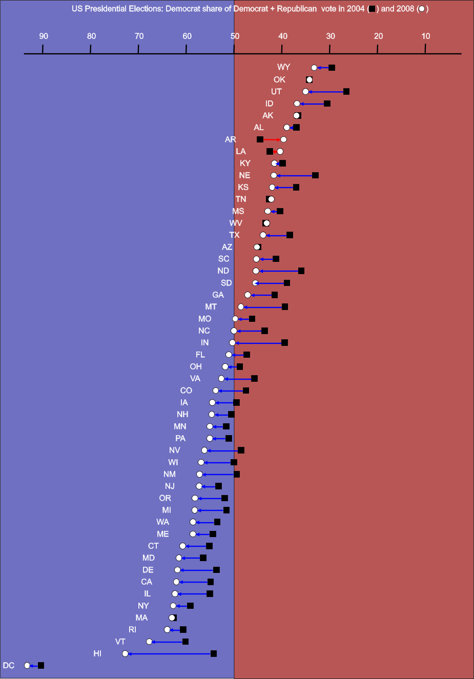
共 和 党 が 州 議 会 の 多 数 を 占 め て い る 。 地 方 や 州 の 役 人 も そ の 大 半 は 共 和 党 員 で あ る 。 た だ 、 1 9 9 2 年 の 大 統 領 選 挙 で は 、 ア ー カ ン ソ ー 州 生 ま れ で 州 知 事 も 経 験 し た 民 主 党 大 統 領 候 補 の ビ ル ・ ク リ ン ト ン に 過 半 数 の 票 を 投 じ た 。 他 の 州 が 3 人 の 候 補 者 の 中 か ら 相 対 多 数 で 選 挙 人 票 を 渡 す 者 を 選 ん で い た の に 対 し 、 ア ー カ ン ソ ー 州 は 特 異 な 存 在 に な っ た 。 近 年 の 大 統 領 選 挙 で ア ー カ ン ソ ー 州 は 共 和 党 へ の 傾 斜 を 強 め て い る 。 2 0 0 8 年 の 大 統 領 選 挙 で は ジ ョ ン ・ マ ケ イ ン が 20 ポ イ ン ト 差 で 州 を 制 し 、 2 0 0 4 年 よ り も 共 和 党 支 持 率 が 増 え た 数 少 な い 州 の 1 つ と な っ た ︵ 他 の 同 様 な 州 は ル イ ジ ア ナ 州 、 テ ネ シ ー 州 、 オ ク ラ ホ マ 州 、 ウ ェ ス ト バ ー ジ ニ ア 州 だ っ た ︶ [ 4 8 ] 。 バ ラ ク ・ オ バ マ が ア ー カ ン ソ ー 州 で 振 る わ な か っ た こ と は 、 ア ー カ ン ソ ー 州 出 身 と 解 釈 さ れ る 元 フ ァ ー ス ト レ デ ィ の ヒ ラ リ ー ・ ク リ ン ト ン が 民 主 党 の 候 補 指 名 を 得 ら れ な か っ た こ と か ら 、 州 民 主 党 か ら 熱 狂 的 な 支 持 を 得 ら れ な か っ た た め と す る 説 が あ る 。 オ バ マ は ま た 田 園 部 白 人 の 間 で も 支 持 率 が 低 か っ た 。
共 和 党 は 主 に 州 北 東 部 、 特 に フ ォ ー ト ス ミ ス や ベ ン ト ン ビ ル 、 さ ら に 北 中 部 の マ ウ ン テ ン ホ ー ム ( M o u n t a i n H o m e , A r k a n s a s ) 周 辺 で 強 い 。 北 中 部 で は 9 0 % 以 上 の 支 持 を 得 て き た 。 州 内 の 南 東 部 は 若 干 民 主 党 寄 り で あ る 。 レ コ ン ス ト ラ ク シ ョ ン 以 来 、 共 和 党 は ア メ リ カ 合 衆 国 上 院 の 2 議 席 共 独 占 し て き た が 、 20 世 紀 は 民 主 党 が 独 占 、 21 世 紀 以 降 は 再 び 共 和 党 が 独 占 し て い る 。 21 世 紀 最 初 の 10 年 間 に 、 民 主 党 が ア メ リ カ 合 衆 国 上 院 の 2 議 席 を 独 占 し た こ と で は 、 旧 ア メ リ カ 連 合 国 に 加 盟 し た 州 の 中 で 3 州 ︵ 他 に フ ロ リ ダ 州 と バ ー ジ ニ ア 州 ︶ し か な い も の の 1 つ に な っ て い る 。 ま た 、 共 和 党 は レ コ ン ス ト ラ ク シ ョ ン 以 降 2 0 1 0 年 代 前 半 ま で 州 議 会 を 制 し た こ と が な く 、 国 内 で も マ サ チ ュ ー セ ッ ツ 州 、 ハ ワ イ 州 、 コ ネ チ カ ッ ト 州 に 次 い で 、 民 主 党 優 勢 な 議 会 に な っ て い た 。
有 権 者 登 録 状 況 を 見 る と 共 和 党 と 民 主 党 が 拮 抗 し て い る が 、 ア ー カ ン ソ ー 州 の 民 主 党 は 特 に リ ト ル ロ ッ ク 市 以 外 で 、 全 国 と 比 較 し て 保 守 的 な 傾 向 が 強 く な っ て い る 。 州 議 会 の 民 主 党 員 は ブ ル ー ド ッ グ 連 衡 ( B l u e D o g C o a l i t i o n ) に 入 っ て お り 、 中 道 か ら 左 派 が 主 流 で あ る 民 主 党 本 流 と 比 較 し て 、 事 業 寄 り 、 軍 事 寄 り 、 か つ 社 会 的 に は 保 守 的 で あ る 。 州 内 に 福 音 主 義 プ ロ テ ス タ ン ト が 多 い こ と も あ っ て 、 社 会 的 に 強 い 保 守 色 を 示 し て い る 。 ア ー カ ン ソ ー 州 憲 法 の 下 で 働 く 権 利 の あ る 州 で あ り 、 有 権 者 は 同 性 結 婚 の 禁 止 に 7 5 % が 同 意 し 、 ﹁ ロ ー 対 ウ ェ イ ド 事 件 ﹂ 最 高 裁 判 決 が 覆 る と き に は 人 工 中 絶 を 再 び 禁 止 す る 法 を 持 つ 数 少 な い 州 の 1 つ で あ る 。
副 知 事 は 州 知 事 と は 別 に 選 出 さ れ る の で 、 両 者 の 所 属 政 党 が 異 な る 場 合 が あ る 。
州 役 人 の 任 期 は 4 年 間 で あ る 。 任 期 制 限 が あ り 、 2 期 プ ラ ス 第 1 期 前 の 部 分 的 な 任 期 と な っ て い る 。 知 事 の 任 期 は 住 民 投 票 で 延 長 が 認 め ら れ る ま で 2 年 間 だ っ た が 、 1 9 8 6 年 の 一 般 選 挙 か ら 4 年 間 に な っ た 。 州 レ ベ ル の 選 挙 は 大 統 領 選 挙 の 年 の 2 年 後 に 行 わ れ て い る 。
郡 内 75 の 郡 の う ち 10 郡 は 2 つ の 郡 庁 所 在 地 を 持 っ て い る 。 こ れ は 郡 内 の 移 動 が 極 め て 困 難 だ っ た 時 代 に 起 源 が あ る 。 郡 庁 所 在 地 は 郡 内 の 北 と 南 と い う ふ う に 対 称 的 な 位 置 に あ る の が 普 通 で あ る 。 移 動 が 容 易 に な っ て 2 つ の 郡 庁 所 在 地 と い う 仕 組 み を 排 除 し よ う と い う 動 き は あ っ た が 、 郡 庁 所 在 地 で あ る と い う こ と が 関 連 す る 町 の 自 負 心 に 繋 が っ て い る た め 、 現 在 も 消 え て い な い 。
ア ー カ ン ソ ー 州 憲 法 第 19 条 ︵ そ の 他 の 規 程 ︶ 第 1 項 は 、 ﹁ 役 職 に つ く 資 格 無 し と さ れ た 、 あ る い は 証 人 と し て 宣 誓 す る 資 格 無 し と さ れ た 無 神 論 者 ﹂ と い う 題 で あ り 、 ﹁ 神 の 存 在 を 否 定 す る 者 は 、 こ の 州 の 公 的 部 門 の 職 に 就 く こ と を 得 ず 、 い か な る 裁 判 所 で も 証 人 と し て 宣 誓 す る こ と が で き な い ﹂ と さ れ て い る 。 し か し 、 1 9 6 1 年 、 ﹁ ト ー カ ソ 対 ワ ト キ ン ス 事 件 ﹂ に つ い て ア メ リ カ 合 衆 国 最 高 裁 判 所 判 決 は 、 メ リ ー ラ ン ド 州 に あ る 同 様 な 要 求 事 項 が ア メ リ カ 合 衆 国 憲 法 修 正 第 1 条 と 同 第 14 条 に 違 背 す る の で 、 こ の 要 求 を 強 制 で き な い と 判 断 し た 。 ア メ リ カ 合 衆 国 憲 法 修 正 第 14 条 は 判 例 に よ っ て 、 修 正 第 1 条 を 含 む 権 利 章 典 が 各 州 を 拘 束 す る も の と し て い る 。 そ の 結 果 、 こ の 要 求 事 項 は 現 代 で は 強 制 で き な い と 見 な さ れ 、 裁 判 所 で 異 議 申 し 立 て が あ っ て も 却 下 さ れ る と 理 解 さ れ て い る 。
ア ー カ ン ソ ー 州 の 2 0 1 0 年 の 総 州 生 産 高 は 1 , 0 3 0 億 米 ド ル で あ り [ 4 9 ] 、 2 0 0 4 年 の 一 人 当 た り の 収 入 中 央 値 は 3 5 , 2 9 5 米 ド ル だ っ た [ 5 0 ] 。 農 業 州 で あ り 、 近 年 は 大 豆 、 モ ロ コ シ や 米 、 鶏 肉 と 鶏 卵 、 牛 、 豚 、 牛 乳 、 綿 花 な ど を 産 す る 。 製 造 業 と し て は 加 工 食 品 、 電 気 機 械 、 金 属 製 品 、 機 械 類 、 紙 製 品 が あ り 、 石 油 、 石 炭 、 ボ ー キ サ イ ト 、 臭 素 、 バ ナ ジ ウ ム な ど の 資 源 も あ る が 経 済 的 水 準 は 低 い 。
ア ー カ ン ソ ー 州 4 分 の 1 ド ル 硬 貨 2 0 1 1 年 8 月 時 点 で 州 内 失 業 率 は 8 . 3 % で あ る 。
州 北 西 隅 に は ウ ォ ル マ ー ト 、 J ・ B ・ ハ ン ト ︵ 輸 送 業 ︶ 、 タ イ ソ ン ・ フ ー ズ ︵ 食 品 加 工 業 ︶ な ど 世 界 的 企 業 数 社 が 本 社 を 置 い て い る [ 5 1 ] 。 世 界 最 大 の 流 通 小 売 業 者 ウ ォ ル マ ー ト は 州 北 西 部 の ベ ン ト ン ビ ル に 本 社 を 置 い て お り 、 同 市 を 企 業 城 下 町 と し て い る 。 こ の 地 域 は 1 9 7 0 年 代 か ら 好 景 気 を 経 験 し て い る 。
近 年 州 東 部 で は 自 動 車 部 品 産 業 の 工 場 が 開 設 さ れ 、 他 州 の 自 動 車 組 み 立 て 工 場 を 支 え て い る 。
観 光 業 も 大 変 重 要 に な っ て き た 。 州 の 公 式 の ニ ッ ク ネ ー ム ﹁ 自 然 の 州 ﹂ は 1 9 7 0 年 代 に 観 光 宣 伝 用 に 作 ら れ 、 今 日 で も 日 常 に 使 わ れ て い る 。 全 米 随 一 の 温 泉 都 市 で あ る ホ ッ ト ス プ リ ン グ ス が 知 ら れ 、 一 帯 は ホ ッ ト ス プ リ ン グ ス 国 立 公 園 と な っ て お り 、 年 間 3 0 0 万 人 が 訪 れ る 一 大 観 光 地 と な っ て い る 。
フ ォ ー ブ ス に 拠 れ ば 、 ア ー カ ン ソ ー 州 は 、 事 業 に 最 適 な 州 で 第 21 位 、 事 業 コ ス ト で 第 9 位 、 労 働 者 に と っ て 第 40 位 、 環 境 規 制 で 第 22 位 、 経 済 観 測 で 第 17 位 、 成 長 見 込 み で 第 9 位 、 州 総 生 産 で 第 34 位 、 経 済 成 長 率 は 3 . 8 % で 第 22 位 と な っ て い る [ 5 2 ] 。
主 要 雇 用 主 [ 編 集 ] ア ー カ ン ソ ー 州 経 済 開 発 委 員 会 に 拠 れ ば 、 2 0 1 0 年 の 雇 用 数 に よ る 企 業 ・ 団 体 順 位 は 以 下 の 通 り で あ る [ 5 3 ] 。
医 療 セ ン タ ー を 含 む ア ー カ ン ソ ー 医 学 大 学 は 上 記 ア ー カ ン ソ ー 州 に 含 ま れ て お り 、 こ れ を 分 離 す れ ば ベ ス ト テ ン に 入 る [ 5 3 ] 。
水 産 養 殖 [ 編 集 ] ア ー カ ン ソ ー 州 は ブ チ ナ マ ズ の 養 殖 で は 国 内 第 3 位 で あ り 、 2 0 1 0 年 時 点 で 約 1 9 , 2 0 0 エ ー カ ー ( 7 7 k m 2 ) が 養 殖 に 使 わ れ て い る 。 最 盛 期 の 2 0 0 2 年 に は 3 8 , 0 0 0 エ ー カ ー ( 1 5 2 k m 2 ) が 養 殖 に 使 わ れ て い た 。 2 0 0 7 年 の 売 り 上 げ は 7 , 1 5 0 万 ド ル と な り 、 国 内 市 場 の 1 6 % に 相 当 し た [ 5 4 ] 。 養 殖 を 始 め た の は 1 9 5 0 年 代 後 半 で あ り 、 国 内 で も 初 め て の こ と だ っ た 。 綿 花 や 大 豆 の 価 格 が 低 下 し た 時 代 に 新 し い 収 入 源 を 求 め た 農 家 が ナ マ ズ 養 殖 業 に 参 入 し 1 9 9 0 年 代 ま で 成 長 を 続 け た 。 銀 行 も 安 定 し た 収 入 源 と 見 な し て 融 資 を 行 っ た 。
ア ー カ ン ソ ー 州 の 郡 配 置 図 ア ー カ ン ソ ー 州 は 州 税 の 所 得 税 と し て 1 . 0 % か ら 7 . 0 % ま で 6 段 階 を 課 し て い る 。 従 軍 中 の 者 の 軍 か ら の 給 与 の う ち 9 , 0 0 0 ド ル は 非 課 税 で あ り 、 士 官 は 6 , 0 0 0 ド ル ま で 非 課 税 で あ る 。 退 職 者 は 社 会 保 障 費 に つ い て 無 税 で あ り 、 年 金 に つ い て は 基 礎 控 除 後 に 6 , 0 0 0 ド ル ま で 非 課 税 で あ る 。 テ キ サ ー カ ナ 市 住 民 は ア ー カ ン ソ ー 州 の 所 得 税 を 払 う 必 要 が な い 。 テ キ サ ス 州 の テ キ サ ー カ ナ 市 住 民 が こ こ で 得 た 賃 金 や 事 業 所 得 も 非 課 税 で あ る 。 消 費 税 と 使 用 税 は 現 在 6 % で あ る 。 様 々 な サ ー ビ ス も 消 費 税 の 対 象 に な っ て い る 。 こ の 中 に は レ ッ カ ー 牽 引 、 ド ラ イ ク リ ー ニ ン グ 、 ボ デ ィ ピ ア ス 、 刺 青 、 電 気 分 解 治 療 、 有 害 生 物 防 除 、 警 備 安 全 監 視 、 倉 庫 サ ー ビ ス 、 ボ ー ト の 保 管 と 修 理 、 ペ ッ ト ケ ア な ど が 含 ま れ て い る 。
州 税 の 消 費 税 に 加 え て 、 3 0 0 以 上 の 地 方 税 が あ る 。 都 市 や 郡 は 地 方 税 を 課 す 権 限 が あ り 、 ま た 有 権 者 の 承 認 で そ れ を 使 う こ と が で き る 。 こ れ ら 地 方 税 に は 上 限 が あ る 。 課 税 評 価 額 の 1 % に つ い て 25 ド ル を 超 え て は な ら な い 。 こ れ ら 地 方 税 は 州 が 徴 収 し 、 毎 月 地 方 政 府 に 配 分 さ れ る 。 世 帯 収 入 が 年 間 1 2 , 0 0 0 ド ル を 下 回 る 低 所 得 者 は 電 気 料 金 に つ い て 消 費 税 を 免 除 さ れ る 。
ア ル コ ー ル 飲 料 の 販 売 は 税 額 が 増 え る 。 レ ス ト ラ ン で ビ ー ル を 除 く ア ル コ ー ル 飲 料 を 販 売 す る と 1 0 % の 加 算 が 行 わ れ る 。 業 務 用 に 販 売 さ れ た 混 酒 ︵ ビ ー ル と ワ イ ン を 除 く ︶ に は 4 % が 付 加 さ れ る 。 業 務 用 の ビ ー ル に は 3 % が 付 加 さ れ る 。
資 産 税 は 個 人 の 不 動 産 に つ い て 評 価 さ れ る 。 評 価 額 の 2 0 % が 課 税 対 象 で あ る 。
2009年時点の道路網 州間高速道路 としては次の路線が州内を通っている
また以下の路線が建設中である
ベラビスタ からテキサーカナグリーンビル からエルドラードギルモア からジョーンズボロこのほかアメリカ国道 は20路線、アーカンソー州道は200以上の路線がある。
商業空港は4か所ある。リトルロック・ナショナル空港、ノースウエストアーカンソー地方空港 、フォートスミス地域空港、およびテキサーカナ地域空港である。他にも多くの小さな空港がある。
アムトラック の旅客列車「テキサス・イーグル号」は、州内のウォルナットリッジ、リトルロック、マルバーン、アーカデルフィア、テキサーカナで停車する。
アーカンソー交通協会に所属するセントラル・アーカンソー交通公社やオザーク地域交通などの機関が、高齢者や身体障害者のために公共輸送サービスを提供している。
教育及び研究センター [ 編集 ] 研究センター [ 編集 ] 単科及び総合大学 [ 編集 ] アーカンソー大学 アーカンソー州立大学 アーカンソー州立大学
Arkansas State University - Jonesboro Arkansas State University - Beebe
Arkansas State University - Mountain Home
Arkansas State University - Newport
Arkansas State University - Marked Tree
Arkansas State University - Heber Springs
Arkansas State University - Searcy その他 [ 編集 ] 同州出身の有名人 [ 編集 ] あ行
か行
さ行
た行
な行
は行
ま行
や行
ら行
わ行
^ The name Arkansas has been pronounced and spelled in a variety of fashions. The region was organized as the Territory of Arkansaw on July 4, 1819, but the territory was admitted to the United States as the state of Arkansas on June 15, 1836. The name was historically , , and several other variants. In 1881, the Arkansas General Assembly passed the following concurrent resolution, now Arkansas Code 1-4-105 (official text ):
Whereas, confusion of practice has arisen in the pronunciation of the name of our state and it is deemed important that the true pronunciation should be determined for use in oral official proceedings.
And, whereas, the matter has been thoroughly investigated by the State Historical Society and the Eclectic Society of Little Rock, which have agreed upon the correct pronunciation as derived from history, and the early usage of the American immigrants.
Be it therefore resolved by both houses of the General Assembly, that the only true pronunciation of the name of the state, in the opinion of this body, is that received by the French from the native Indians and committed to writing in the French word representing the sound. It should be pronounced in three (3) syllables, with the final "s" silent, the "a" in each syllable with the Italian sound, and the accent on the first and last syllables. The pronunciation with the accent on the second syllable with the sound of "a" in "man" and the sounding of the terminal "s" is an innovation to be discouraged.
Citizens of the state of Kansas often pronounce the Arkansas River as , in a manner similar to the common pronunciation of the name of their state.
(一) ^ a b “ C e n s u s R e g i o n s a n d D i v i s i o n s o f t h e U n i t e d S t a t e s ” . G e o g r a p h y D i v i s i o n , U n i t e d S t a t e s C e n s u s B u r e a u . 2 0 1 2 年 6 月 23 日 閲 覧 。 (二) ^ C a s h , M a r i e ( D e c e m b e r 1 9 4 3 ) . “ A r k a n s a s A c h i e v e s S t a t e h o o d ” . A r k a n s a s H i s t o r i c a l Q u a r t e r l y ( A r k a n s a s H i s t o r i c a l A s s o c i a t i o n ) 2 . (三) ^ M L A L a n g u a g e M a p D a t a C e n t e r " . M o d e r n L a n g u a g e A s s o c i a t i o n . (四) ^ 木 村 正 史 , 由 良 力 , 三 浦 常 司 、 ﹁ ア メ リ カ 合 衆 国 の 州 の ニ ッ ク ネ ー ム に つ い て ﹂ ﹃ 神 戸 大 学 医 学 部 保 健 学 科 紀 要 ﹄ 1 9 9 4 年 10 号 p . 1 - 2 6 , 神 戸 大 学 医 学 部 保 健 学 科 (五) ^ “ L i n g u i s t l i s t 1 4 . 4 ” . L i s t s e r v . l i n g u i s t l i s t . o r g ( 2 0 0 3 年 2 月 11 日 ) . 2 0 1 0 年 7 月 30 日 閲 覧 。 [ リ ン ク 切 れ ] (六) ^ H i s t o r i c a l C e n s u s B r o w s e r , 1 8 6 0 U S C e n s u s , U n i v e r s i t y o f V i r g i n i a . R e t r i e v e d M a r c h 2 1 , 2 0 0 8 . (七) ^ “ B r o o k s - B a x t e r W a r – E n c y c l o p e d i a o f A r k a n s a s ” . 2 0 0 7 年 9 月 29 日 時 点 の オ リ ジ ナ ル よ り ア ー カ イ ブ 。 2 0 0 7 年 8 月 24 日 閲 覧 。 (八) ^ W i l l i a m D . B a k e r , M i n o r i t y S e t t l e m e n t i n t h e M i s s i s s i p p i R i v e r C o u n t i e s o f t h e A r k a n s a s D e l t a , 1 8 7 0 – 1 9 3 0 , A r k a n s a s P r e s e r v a t i o n C o m m i s s i o n . R e t r i e v e d M a y 1 4 , 2 0 0 8 (九) ^ “ L i t t l e R o c k N i n e – E n c y c l o p e d i a o f A r k a n s a s ” . 2 0 0 7 年 9 月 29 日 時 点 の オ リ ジ ナ ル よ り ア ー カ イ ブ 。 2 0 0 7 年 8 月 24 日 閲 覧 。 (十) ^ A r k a n s a s A t l a s a n d G a z e t t e e r ( M a p ) ( S e c o n d e d . ) . D e L o r m e . (11) ^ S m i t h , R i c h a r d M . ( 1 9 8 9 ) . T h e A t l a s o f A r k a n s a s . T h e U n i v e r s i t y o f A r k a n s a s P r e s s . p . 1 5 . I S B N 1 5 5 7 2 8 0 4 7 9 (12) ^ S m i t h , R i c h a r d M . ( 1 9 8 9 ) . T h e A t l a s o f A r k a n s a s . T h e U n i v e r s i t y o f A r k a n s a s P r e s s . p p . 1 5 - 1 7 . I S B N 1 5 5 7 2 8 0 4 7 9 (13) ^ “ A r k a n s a s R e g i o n s ” . D i s c o v e r A r k a n s a s H i s t o r y . T h e D e p a r t m e n t o f A r k a n s a s H e r i t a g e . 2 0 1 2 年 6 月 28 日 閲 覧 。 (14) ^ S m i t h , R i c h a r d M . ( 1 9 8 9 ) . T h e A t l a s o f A r k a n s a s . T h e U n i v e r s i t y o f A r k a n s a s P r e s s . p . 1 9 . I S B N 1 5 5 7 2 8 0 4 7 9 (15) ^ O z a r k M o u n t a i n s . E n c y c l o p e d i a B r i t a n n i c a . (16) ^ S m i t h , R i c h a r d M . ( 1 9 8 9 ) . T h e A t l a s o f A r k a n s a s . T h e U n i v e r s i t y o f A r k a n s a s P r e s s . p . 2 4 . I S B N 1 5 5 7 2 8 0 4 7 9 (17) ^ S m i t h , R i c h a r d M . ( 1 9 8 9 ) . T h e A t l a s o f A r k a n s a s . T h e U n i v e r s i t y o f A r k a n s a s P r e s s . p . 2 5 . I S B N 1 5 5 7 2 8 0 4 7 9 (18) ^ “ C r a t e r o f D i a m o n d s : H i s t o r y o f d i a m o n d s , d i a m o n d m i n i n g i n A r k a n s a s ” . C r a t e r o f d i a m o n d s s t a t e p a r k . c o m . 2 0 1 0 年 8 月 21 日 時 点 の オ リ ジ ナ ル よ り ア ー カ イ ブ 。 2 0 1 0 年 7 月 30 日 閲 覧 。 (19) ^ “ U S D i a m o n d M i n e s – D i a m o n d M i n i n g i n t h e U n i t e d S t a t e s ” . G e o l o g y . c o m . 2 0 1 0 年 7 月 24 日 時 点 の オ リ ジ ナ ル よ り ア ー カ イ ブ 。 2 0 1 0 年 7 月 30 日 閲 覧 。 (20) ^ E c o l o g i c a l R e g i o n s o f N o r t h A m e r i c a ( P D F ) ( M a p ) . 1 : 1 0 0 0 0 0 0 0 . U n i t e d S t a t e s E n v i r o n m e n t a l P r o t e c t i o n A g e n c y . 2 0 1 2 年 7 月 5 日 閲 覧 。 (21) ^ E c o r e g i o n s o f A r k a n s a s ( P D F ) ( M a p ) . U n i t e d S t a t e s E n v i r o n m e n t a l P r o t e c t i o n A g e n c y . 2 0 1 2 年 7 月 5 日 閲 覧 。 (22) ^ “ F o r e s t I n v e n t o r y a n d A n a l y s i s ” ( X L S ) . U n i t e d S t a t e s F o r e s t S e r v i c e , S o u t h e r n R e s e a r c h S t a t i o n ( 2 0 1 0 年 ) . 2 0 1 2 年 7 月 5 日 閲 覧 。 (23) ^ P r o c e e d i n g s o f t h e S y m p o s i u m o n A r k a n s a s F o r e s t s : A C o n f e r e n c e o n t h e R e s u l t s o f t h e R e c e n t F o r e s t S u r v e y o f A r k a n s a s , U n i t e d S t a t e s F o r e s t S e r v i c e , M a y 3 0 – 3 1 , 1 9 9 7 , p a g e 7 4 (24) ^ D a l e , J r , E d w a r d E . ; W a r e , S t e w a r t ( A p r i l - J u n e , 2 0 0 4 ) . “ D i s t r i b u t i o n o f W e t l a n d T r e e S p e c i e s i n R e l a t i o n t o a F l o o d i n g G r a d i e n t a n d B a c k w a t e r v e r s u s S t r e a m s i d e L o c a t i o n i n A r k a n s a s , U . S . A . ” . J o u r n a l o f t h e T o r r e y B o t a n i c a l S o c i e t y ( T o r r e y B o t a n i c a l S o c i e t y ) 1 3 1 : 1 7 7 - 1 8 6 . (25) ^ L a n d s c o p e A m e r i c a : A r k a n s a s C o n s e r v a t i o n S u m m a r y (26) ^ F i t z p a t r i c k , J o h n W . ; L a m m e r t i n k , M a r t j a n ; L u n e a u , M . D a v i d J r . ; G a l l a g h e r , T i m W . ; H a r r i s o n , B o b b y R . ; S p a r l i n g , G e n e M . ; R o s e n b e r g , K e n n e t h V . ; R o h r b a u g h , R o n a l d W . ; S w a r t h o u t , E l l i o t t C . H . ; W r e g e , P e t e r H . ; S w a r t h o u t , S a r a B a r k e r ; D a n t z k e r , M a r c S . ; C h a r i f , R u s s e l l A . ; B a r k s d a l e , T i m o t h y R . ; R e m s e n , J . V . J r ; S i m o n , S c o t t D . & Z o l l n e r , D o u g l a s ( 2 0 0 5 ) : I v o r y - b i l l e d w o o d p e c k e r ( C a m p e p h i l u s p r i n c i p a l i s ) p e r s i s t s i n c o n t i n e n t a l N o r t h A m e r i c a . S c i e n c e 3 0 8 ( 5 7 2 7 ) : 1 4 6 0 - 1 4 6 2 . d o i : 1 0 . 1 1 2 6 / s c i e n c e . 1 1 1 4 1 0 3 P M I D 1 5 8 6 0 5 8 9 p r e p r i n t P D F f u l l t e x t S u p p o r t i n g O n l i n e M a t e r i a l (27) ^ “ C l i m a t e - F a y e t t e v i l l e - A r k a n s a s ” . U . S . C l i m a t e D a t a . 2 0 1 2 年 6 月 28 日 閲 覧 。 (28) ^ “ C l i m a t e - J o n e s b o r o - A r k a n s a s ” . U . S . C l i m a t e D a t a . 2 0 1 2 年 6 月 28 日 閲 覧 。 (29) ^ “ M o n t h l y A v e r a g e s f o r L i t t l e R o c k , A R ” . T h e W e a t h e r C h a n n e l . 2 0 1 2 年 6 月 28 日 閲 覧 。 (30) ^ “ C l i m a t e - T e x a r k a n a - T e x a s ” . U . S . C l i m a t e D a t a . 2 0 1 2 年 6 月 28 日 閲 覧 。 (31) ^ “ C l i m a t e - M o n t i c e l l o - A r k a n s a s ” . U . S . C l i m a t e D a t a . 2 0 1 2 年 6 月 28 日 閲 覧 。 (32) ^ R e s i d e n t P o p u l a t i o n D a t a . “ R e s i d e n t P o p u l a t i o n D a t a - 2 0 1 0 C e n s u s ” . 2 0 1 0 . c e n s u s . g o v . 2 0 1 2 年 2 月 18 日 閲 覧 。 (33) ^ a b c d Q u i c k F a c t s . U . S . C e n s u s B u r e a u . 2 0 2 0 年 . (34) ^ A r n o l d , M o r r i s S . ; D e B l a c k , T h o m a s A . ; S a b o I I I , G e o r g e ; W h a y n e , J e a n n i e M . ( 2 0 0 2 ) . “ T h e T u r b u l e n t P a t h t o S t a t e h o o d ” . A r k a n s a s : A n a r r a t i v e h i s t o r y ( 1 s t e d . ) . F a y e t t e v i l l e , A r k a n s a s : T h e U n i v e r s i t y o f A r k a n s a s P r e s s . p . 1 0 6 . I S B N 1 - 5 5 7 2 8 - 7 2 4 - 4 . O C L C 4 9 0 2 9 5 5 8 (35) ^ H o l l e y , D o n a l d ( A u t u m n 2 0 0 5 ) . “ L e a v i n g t h e L a n d o f O p p o r t u n i t y : A r k a n s a s a n d t h e G r e a t M i g r a t i o n ” . A r k a n s a s H i s t o r i c a l Q u a r t e r l y ( A r k a n s a s H i s t o r i c a l A s s o c i a t i o n ) 64 : 2 4 7 - 2 4 8 . (36) ^ “ R e s i d e n t P o p u l a t i o n D a t a ” . U n i t e d S t a t e s C e n s u s B u r e a u . 2 0 1 2 年 7 月 4 日 閲 覧 。 (37) ^ “ A r k a n s a s Q u i c k F a c t s ” . U n i t e d S t a t e s C e n s u s B u r e a u ( 2 0 1 2 年 6 月 7 日 ) . 2 0 1 2 年 7 月 4 日 閲 覧 。 (38) ^ “ A r k a n s a s 2 0 0 0 C e n s u s P o p u l a t i o n C e n t e r ” . N O A A . 2 0 1 2 年 7 月 4 日 閲 覧 。 (39) ^ D a v i d H a c k e t t F i s c h e r , A l b i o n ' s S e e d : F o u r B r i t i s h F o l k w a y s i n A m e r i c a , N e w Y o r k : O x f o r d U n i v e r s i t y P r e s s , 1 9 8 9 , p p . 6 3 3 – 6 3 9 (40) ^ “ A r k a n s a s Q u i c k F a c t s ” . U . S . C e n s u s B u r e a u . 2 0 1 2 年 8 月 4 日 閲 覧 。 (41) ^ A m e r i c a n F a c t F i n d e r , U n i t e d S t a t e s C e n s u s B u r e a u ( 2 0 1 0 年 ) . “ A r k a n s a s – S e l e c t e d S o c i a l C h a r a c t e r i s t i c s i n t h e U n i t e d S t a t e s ” . A m e r i c a n C o m m u n i t y S u r v e y . 2 0 1 2 年 7 月 4 日 閲 覧 。 (42) ^ S h a r i n g t h e D r e a m : W h i t e M a l e s i n a M u l t i c u l t u r a l A m e r i c a B y D o m i n i c J . P u l e r a . (43) ^ R e y n o l d s F a r l e y , ' T h e N e w C e n s u s Q u e s t i o n a b o u t A n c e s t r y : W h a t D i d I t T e l l U s ? ' , D e m o g r a p h y , V o l . 2 8 , N o . 3 ( A u g u s t 1 9 9 1 ) , p p . 4 1 4 , 4 2 1 . (44) ^ S t a n l e y L i e b e r s o n a n d L a w r e n c e S a n t i , ' T h e U s e o f N a t i v i t y D a t a t o E s t i m a t e E t h n i c C h a r a c t e r i s t i c s a n d P a t t e r n s ' , S o c i a l S c i e n c e R e s e a r c h , V o l . 1 4 , N o . 1 ( 1 9 8 5 ) , p p . 4 4 – 6 . (45) ^ S t a n l e y L i e b e r s o n a n d M a r y C . W a t e r s , ' E t h n i c G r o u p s i n F l u x : T h e C h a n g i n g E t h n i c R e s p o n s e s o f A m e r i c a n W h i t e s ' , A n n a l s o f t h e A m e r i c a n A c a d e m y o f P o l i t i c a l a n d S o c i a l S c i e n c e , V o l . 4 8 7 , N o . 7 9 ( S e p t e m b e r 1 9 8 6 ) , p p . 8 2 – 8 6 . (46) ^ S m i t h , D a r l e n e ( S p r i n g 1 9 5 4 ) . “ A r k a n s a s P o s t ” . A r k a n s a s H i s t o r i c a l Q u a r t e r l y ( A r k a n s a s H i s t o r i c a l A s s o c i a t i o n ) 13 : 1 2 0 . (47) ^ “ E s t i m a t e s o f P o p u l a t i o n C h a n g e f o r M e t r o p o l i t a n S t a t i s t i c a l A r e a s a n d R a n k i n g s ” ( X L S ) . U n i t e d S t a t e s C e n s u s B u r e a u ( J u l y 1 , 2 0 1 0 t o J u l y 1 , 2 0 1 1 ) . 2 0 1 2 年 7 月 8 日 閲 覧 。 (48) ^ h t t p : / / u p l o a d . w i k i m e d i a . o r g / w i k i p e d i a / c o m m o n s / 5 / 5 4 / E l e c t i o n - s t a t e - 0 4 - 0 8 . p n g (49) ^ “ G D P b y S t a t e ” . G r e y h i l l A d v i s o r s . 2 0 1 1 年 9 月 23 日 閲 覧 。 (50) ^ A r k a n s a s Q u i c k F a c t s f r o m t h e U S C e n s u s B u r e a u (51) ^ S t a f f W r i t e r . " F o r t u n e G l o b a l 5 0 0 . " C N N / F o r t u n e . 2 0 0 7 . R e t r i e v e d o n N o v e m b e r 8 , 2 0 0 7 . (52) ^ “ T a b l e : T h e B e s t S t a t e s F o r B u s i n e s s ” . F o r b e s . ( 2 0 0 7 年 7 月 11 日 ) . オ リ ジ ナ ル の 2 0 1 0 年 8 月 25 日 時 点 に お け る ア ー カ イ ブ 。 . https://web.archive.org/web/20100825164310/http://www.forbes.com/2007/07/10/washington-virginia-utah-biz-cz_kb_0711bizstates-table.html 2 0 1 0 年 7 月 30 日 閲 覧 。 (53) ^ a b " A r k a n s a s ’ L a r g e s t E m p l o y e r s – 2 0 1 0 " ( A u g u s t 2 0 1 0 ) . A r k a n s a s E c o n o m i c D e v e l o p m e n t C o m m i s s i o n , R e s e a r c h D i v i s i o n . (54) ^ h t t p : / / u s d a . m a n n l i b . c o r n e l l . e d u / u s d a / n a s s / C a t f P r o d / / 2 0 0 0 s / 2 0 0 2 / C a t f P r o d - 0 2 - 0 7 - 2 0 0 2 . p d f 参考文献 [ 編集 ]
Blair, Diane D. & Jay Barth Arkansas Politics & Government:Do the People Rule? (2005)
Deblack, Thomas A. With Fire and Sword:Arkansas, 1861–1874 (2003)
Donovan, Timothy P. and Willard B. Gatewood Jr., eds. The Governors of Arkansas (1981)
Dougan, Michael B. Confederate Arkansas (1982),
Duvall, Leland. ed., Arkansas:Colony and State (1973)
Fletcher, John Gould. Arkansas (1947)
Hamilton, Peter Joseph. The Reconstruction Period (1906), full length history of era;Dunning School approach;570 pp;ch 13 on ArkansasHanson, Gerald T. and Carl H. Moneyhon. Historical Atlas of Arkansas (1992)
Key, V. O. Southern Politics (1949)
Kirk, John A., Redefining the Color Line:Black Activism in Little Rock, Arkansas, 1940–1970 (2002).
McMath, Sidney S. Promises Kept (2003)
Moore, Waddy W. ed., Arkansas in the Gilded Age, 1874–1900 (1976).
Peirce, Neal R. The Deep South States of America:People, Politics, and Power in the Seven Deep South States (1974)\
Thompson, Brock. The Un-Natural State:Arkansas and the Queer South (2010)
Thompson, George H. Arkansas and Reconstruction (1976)
Whayne, Jeannie M. et al. Arkansas:A Narrative History (2002)
Whayne, Jeannie M. Arkansas Biography:A Collection of Notable Lives (2000)
White, Lonnie J. Politics on the Southwestern Frontier:Arkansas Territory, 1819–1836 (1964)
Williams, C. Fred. ed. A Documentary History Of Arkansas (2005)
WPA., Arkansas:A Guide to the State (1941)
関連項目 [ 編集 ] 外部リンク [ 編集 ]
ウィキメディア・コモンズには、
アーカンソー州 に関連するメディアがあります。
座標 : 北緯34度48分 西経92度12分 / 北緯34.8度 西経92.2度 / 34.8; -92.2


 州都リトルロックはアーカンソー州最大の都市でもある。
 州第2の都市フェイエットビル
 州第3の都市フォートスミス
 州第4の都市スプリングデール
 州第5の都市ジョーンズボロ


 州間高速道路30号線
 州間高速道路40号線
 州間高速道路55号線
 州間高速道路430号線 接続線
 州間高速道路440号線 接続線
 州間高速道路530号線 拡張線
 州間高速道路540号線 拡張線
 州間高速道路630号線 接続線
 州間高速道路49号線 ベラビスタからテキサーカナ
 州間高速道路69号線 ミシシッピ州グリーンビルからエルドラード
 州間高速道路130号線 テキサーカナ地域への接続線
 州間高速道路555号線 ギルモアからジョーンズボロ

 アーカンソー州に関連する地理データ - オープンストリートマップ