
ウォルサム・フォレスト区
| ウォルサム・フォレスト区 London Borough of Waltham Forest | |
|---|---|
| ロンドン自治区 | |
 グレーター・ロンドン内における区の位置 | |
| 地位 | ロンドン自治区 |
| 主権国家 | |
| 構成国 | |
| リージョン | ロンドン |
| 典礼カウンティ | グレーター・ロンドン |
| 設置 | 1965年4月1日 |
| 区役所所在地 | Walthamstow |
| 行政 | |
| • 種別 | ロンドン区 |
| • 議会 | ウォルサム・フォレスト・ロンドン区議会 |
| • 統治体制 | リーダーと内閣制 (労働党) |
| • 首長 | Peter Herrington |
| • ロンドン議会議員 | Jennette Arnold (Lab) (North East区選出) |
| • 英国議会下院議員 | John Cryer (Lab), Stella Creasy (Lab), Iain Duncan Smith (Con) |
| • 欧州議会 | ロンドン選挙区 |
| 面積 | |
| • 計 | 38.82 km2 |
| 域内順位 | 286位(全317地域中) |
| 人口(2018年中期推計値) | |
| • 計 | 276,700人 |
| • 順位 | 53位(全317地域中) |
| • 密度 | 7,100人/km2 |
| • 民族構成[1]人口密度 | 36% イギリス系白人 1.5% アイルランド系白人 0.1% ジプシー系白人又はアイリッシュ・トラベラー 14.5% その他の白人 1.8% 白人とカリブ系黒人の混血 0.9% 白人とアフリカ系黒人の混血 1% 白人とアジア系の混血 1.6% その他の混血 3.5% インド系 10.2% パキスタン系 1.8% バングラデシュ系 1% 中国系 4.5% その他のアジア系 7.3% アフリカ系黒人 7.3% カリブ系黒人 2.8% その他の黒人 1.5% アラブ系 2.6% その他の民族 |
| 等時帯 | GMT(UTC+0) |
| • 夏時間(DST) | BST(UTC+1) |
| 郵便コード | E, IG |
| 市外局番 | 020 |
| ONSコード | 00BH |
| GSSコード | E09000031 |
| 警察機関 | ロンドン警視庁 |
| 消防機関 | ロンドン消防局 |
| ウェブサイト | www |
ウォルサム・フォレスト・ロンドン自治区︵ウォルサム・フォレスト・ロンドンじちく、英: London Borough of Waltham Forest︶は、イングランドのロンドン︵グレーター・ロンドン︶北東部に位置するロンドン自治区で、アウター・ロンドンの一角をなす。1963年ロンドン政府法により設置された [2]:5 。
近年は宅地開発が進む一方で、東部のエッピングの森と西部を流れるリー川との間には森林、貯水池、オープン・スペース、公園、運動場などが整備されている。よくグレーター・ロンドンの外郭に位置するエッピング・フォレスト地区と混同される。

A map showing the wards of Walth am Forest since 2002
※以下、タウンないしエリア、地区︵district︶を示す。
歴史[編集]
この地では石器時代の史跡が多数発見されており、点在するローマの遺跡は往時この地が重要な拠点だったことを物語る。特別区自体は1963年に制定されたロンドン行政法に基づき、1965年にチングフォード︵エセックスからグレーター・ロンドンに編入︶、レイトン、ウォルサムストウの各自治都市が合併し誕生した。区名はエッピングの森の別名、ウォルサムの森︵Waltham Forest︶にちなむ。1878年にはエッピングの森法が制定されたが、その後も3自治都市周辺で開発が進んだ。現在ではシティ・オブ・ロンドンとエッピングの森の間に位置する区の大部分が開発され、都市部になっている。コミュニティ[編集]
人口は北部のチングフォード、行政機関や議会が置かれる中部のウォルサムストウ、南部のレイトンとレイトンストーンに集中している。 また、イングランドで5番目、ロンドンではニューアムとタワー・ハムレッツの各区に次ぐ3番目のムスリム人口を有する。文化[編集]
長年国内のチャートに入るイースト17やブレイジン・スクワッドの拠点で、グライム音楽の発祥地でもある。この特別区出身のグライムアーティストにはモア・ファイア・クルー、リザル・ビスル、ニーコ、ジャマー、オジーBなどがいる。ウィリアム・モリスのアート・アンド・クラフツ運動も盛んで、今でも多くの現代アーティストや芸術団体が支援を受けている。主な支援団体としてはルロイド・パークのチェンジング・ルーム・ギャラリーを拠点とする北東ロンドン独立アーティスト︵NELIA︶がいる。毎年E17アート・トレイルという大規模イベントが開かれ、オープンスタジオや展示会などが開かれる。スティッキズム芸術運動の始祖であるイーモン・エヴァラールは長年この地で暮らし、スタジオを一軒所有している。2005年に﹁今年のウェールズ人アーティスト﹂に選出されたサリー・ムーアもここの住人である。 ルロイド・パークのウォルサム・フォレスト・シアターは資金難のため近々取り壊される予定で、存続を求める住民運動が行われている[3]。 かつてはパスカル・プティ、ジャクリーヌ・ギャビタ、メリル・パフなどの詩人が暮らしたほか、アイスリング・フェイヒー、ロブ・オートン、デイヴ・ブライアント、ジョエル・タイラー、デイヴィッド・フロイド、エマ、ハモンドといった詩人もゆかりがある。オリンピック[編集]
ウォルサム・フォレスト区は、2012年ロンドンオリンピックで会場となるイースト・ロンドン︵en︶の4つの区の一つであった。レイトンのイートン・マナー︵Eton Manor, 現Lee Valley Hockey and Tennis Centre︶は、会場のクイーン・エリザベス・オリンピック・パーク︵en︶内の北部を構成する。既存のスイミングプールのうち、競泳が3ヵ所、シンクロが1ヶ所、水球が1ヶ所オリンピック用のトレーニングプールに用いられた。 同2012年ロンドンパラリンピックではイートン・マナーが1万500人を収容できる車いすテニス会場になった。教育[編集]
幼稚園・小学校[編集]
●エインズリー・ウッド小学校︵Ainslie Wood Primary School︶ ●バルクレー小学校︵Barclay Primary School︶ ●バーン・クロフト小学校︵Barn Croft Primary School︶ ●ボーモント小学校︵Beaumont Primary School︶ ●カン・ホール小学校︵Cann Hall Primary School︶ ●チャペル・エンド幼稚園︵Chapel End Infants' School︶ ●チャペル・エンド小学校︵Chapel End Junior School︶ ●チェイス・レーン小学校︵Chase Lane Primary School︶ ●チングフォード国教会系幼稚園︵Chingford CofE Infant School︶ ●チングフォード国教会系小学校︵Chingford CofE Junior School︶ ●チングフォード・ホール・コミュニティ小学校︵Chingford Hall Community Primary School︶ ●コッパーミル小学校︵Coppermill Primary School︶ ●デイヴィス・レーン小学校︵Davies Lane Primary School︶ ●ドーリッシュ小学校︵Dawlish Primary School︶ ●ダウンセル小学校︵Downsell Primary School︶ ●エディンバラ小学校︵Edinburgh Primary School︶ ●ジョージ・トンリンソン小学校︵George Tomlinson Primary School︶ ●グリーンリーフ小学校︵Greenleaf Primary School︶ ●グウィン・ジョーンズ小学校︵Gwyn Jones Primary School︶ ●ハンズワース小学校︵Handsworth Primary School︶ ●ヘンリー・メイナード幼稚園︵Henry Maynard Infants' School︶ ●ヘンリー・メイナード小学校︵Henry Maynard Junior School︶ ●ヒリーフィールド小学校︵Hillyfield Primary School︶ ●ジェニー・ハモンド・スクール︵Jenny Hammond School︶ ●ラークスウッド小学校︵Larkswood Primary School︶ ●ロングショウ小学校︵Longshaw Primary School︶ ●メイヴィル小学校︵Mayville Primary School︶ ●ミッション・グローヴ小学校︵Mission Grove Primary School︶ ●ニューポート・スクール︵Newport School︶ ●ノーマンハースト・スクール︵Normanhurst School︶ ●オークヒル小学校︵Oakhill Primary School︶ ●リヴァーリー小学校︵Riverley Primary School︶ ●ロジャー・アスチャム小学校︵Roger Ascham Primary School︶ ●セルウィン小学校︵Selwyn Primary School︶ ●サウス・グローヴ小学校︵South Grove Primary School︶ ●セント・ヘレンズ・カトリック系幼稚園︵St Helen's Catholic Infant School︶ ●セント・ジョゼフズ・カトリック系幼稚園︵St Joseph's Catholic Infant School︶ ●セント・ジョゼフズ・カトリック系小学校︵St Joseph's Catholic Junior School︶ ●セント・メアリーズ・カトリック系小学校︵St Mary's Catholic Junior School︶ ●セント・メアリーズ・カトリック系小学校︵St Mary's Catholic Primary School︶ ●セント・メアリーズ国教会系有志団体立補助小学校︵St Mary's CofE VA Primary School︶ ●セント・パトリックス・カトリック系小学校︵St Patrick's Catholic Primary School︶ ●セント・サヴィアーズ国教会系有志団体立補助小学校︵St Saviour's CofE Voluntary Aided Primary School︶ ●ストニーダウン・パーク小学校︵Stoneydown Park Primary School︶ ●シーバーン幼稚園︵Sybourn Infants' School︶ ●シーバーン小学校︵Sybourn Junior School︶ ●ザ・ウッドサイド・スクール︵The Woodside School︶ ●トーマス・ガムエル小学校︵Thomas Gamuel Primary School︶ ●ソープ・ホール小学校︵Thorpe Hall Primary School︶ ●ウェリントン小学校︵Wellington Primary School︶ ●ホワイトホール小学校︵Whitehall Primary School︶ ●ホイッティンガム・コミュニティ小学校︵Whittingham Community Primary School︶ ●ウィロウ・ブルック小学校︵Willow Brook Primary School︶ ●ウッドフォード・グリーン小学校︵Woodford Green Primary School︶ ●ヤードリー小学校︵Yardley Primary School︶中等学校[編集]
●フレデリック・ブレマー・スクール︵Frederick Bremer School、公立︶ ●チングフォード財団学校︵Chingford Foundation School、アカデミー[4]︶ ●コンノート女学校︵Connaught School for Girls、公立︶ ●フォレスト・スクール︵Forest School、パブリック・スクール︶ ●ジョージ・ミッチェル・スクール︵George Mitchell School、公立︶ ●ハースコート・スクール︵Heathcote School、公立︶ ●ヒッガムズ・パーク・スクール︵Highams Park School、公立︶ ●聖家族カトリック系カレッジ︵The Holy Family Catholic College、私立︶ ●ケルムスコット・スクール︵Kelmscott School、公立︶ ●ザ・ラマス・スクール︵The Lammas School、公立︶ ●レイトン6年制カレッジ︵Leyton Sixth Form College、公立︶ ●レイトンストーン・スクール︵Leytonstone School、または レイトンストーン商業・経営専門学校︵Leytonstone Business and Enterprise Specialist School、公立︶ ●ノーリントン男子校︵Norlington School for Boys、アカデミー︶ ●ノーマンハースト・スクール︵Normanhurst School、私立︶ ●ラッシュ・クロフト・スポーツ・カレッジ︵Rush Croft Sports College、公立︶ ●サー・ジョージ・モヌックス・カレッジ︵Sir George Monoux College、公立︶ ●トム・フッド・コミュニティ・サイエンス・カレッジ︵Tom Hood Community Science College、公立︶ ●ウォルサム・フォレスト・カレッジ︵Waltham Forest College、公立︶ ●ウォルサムストウ・アカデミー︵Walthamstow Academy、アカデミー︶ ●ウォルサムストウ女子校︵Walthamstow School for Girls、公立︶ ●ウィロウフィールド・スクール︵Willowfield School、公立︶地理[編集]
北部はエセックス州と接する。北西部はインフィールド区、西部はハーリンゲイ区、南西部はハックニー区とそれぞれ接する。 東部はレッドブリッジ区、南東部はニューアム区になる。地区[編集]

- ベイカーズ・アームズ(Bakers Arms)
- カーン・ホール(Cann Hall)
- チングフォード(Chingford)
- チングフォード・ハッチ(Chingford Hatch)
- フライデー・ヒル(Friday Hill)
- ヘイル・エンド(Hale End)
- ハイアムズ・パーク(Highams Park)
- レイトン(Leyton)
- カーン・ホールやレイトンストーンなどと共に区南端側にあり、イーストエンド・オブ・ロンドン界隈にあたる。
- レイトンストーン(Leytonstone)
- アッパー・ウォルサムストウ(Upper Walthamstow)
- ウォルサムストウ(Walthamstow)
- ウィップス・クロス(Whipps Cross)
- 大きくレイトンストーンとウォルサムストウの2地区に包含される地区になる。
下位行政地区[編集]
※ 以下、下位行政地区(Ward)を示す。
- カン・ホール(Cann Hall)
- カザル(Cathall)
- チャペル・エンド(Chapel End)
- チングフォード・グリーン(Chingford Green)
- エンドルバリー(Endlebury)
- フォレスト(Forest)
- グローヴ・グリーン(Grove Green)
- ヘール・エンドとヒッガムズ・パーク(Hale End and Highams Park)
- ハッチ・レーン(Hatch Lane)
- ハイ・ストリート(High Street)
- ヒッガム・ヒル(Higham Hill)
- ホー・ストリート(Hoe Street)
- ラークスウッド(Larkswood)
- リー・ブリッジ(Lea Bridge) - 区西部ハックニー区に跨がる。
- レイトン(Leyton)
- レイトンストーン(Leytonstone)
- マークハウス(Markhouse)
- ウィリアム・モリス(William Morris)
- ウッド・ストリート(Wood Street)
- ヴァレー(Valley)
郵便番号[編集]
- E4
- E5
- E7
- E10
- E11
- E15
- E17
- IG8
交通[編集]
A12号線に沿ってロンドン地下鉄のセントラル線が区の南部を通っており、レイトン駅とレイトンストーン駅が置かれている。区の中心部にはヴィクトリア線が通り、ウォルサムストウ・セントラル駅とブラックホース・ロード駅の二駅がある。ロンドン・オーヴァーグラウンドのゴスペル・オーク・トゥ・バーキング線も通り、ウォルサムストウ・クイーンズ・ロード、ブラックホース・ロード、レイトン・ミッドランド・ロード、レイトンストーン・ハイ・ロードの四駅がある。イギリス国鉄東アングリア社のリー・ヴァレー線も区内のジェイムズ・ストリート、ウォルサムストウ・セントラル、ウッド・ストリート、ヒッガムズ・パーク、チングフォードの各駅に停車する。
法執行[編集]
役所の隣に治安判事裁判所があるが、公費削減のため近々廃止される。チングフォード、レイトン、レイトンストーン、ウォルサムストウとウォルサムストウ中心街の5箇所に警察署があるほか、あちこちにパトロールセンターが置かれている。通りの警備強化も図られている。ゆかりの人物[編集]

「#文化」も参照
ロンドン北東部︵East London︶のウォルサム・フォレスト界隈は、イギリスのアーツ・アンド・クラフツ運動の主導者であるウィリアム・モリス生誕の地である︵ウォルサムストウ生まれ︶。アーツ・アンド・クラフツ以外でも、モリスは壁紙や織物のテキスタイルデザイナー、詩人、ファンタジー作家、社会主義者でもあった。
その他、この地にゆかりのある人物や団体は以下。元クリケットイングランド代表キャプテンのグラハム・グーチ︵en︶、元サッカーイングランド代表キャプテンのデイヴィッド・ベッカム、女優のリタ・シモンズ︵en︶らは、いずれもレイトンストーン︵ウィップス・クロス︶にあるウィップス・クロス大学病院︵en︶生まれ。映画監督・プロデューサーのアルフレッド・ヒッチコック、テレビドラマ﹃この私、クラウディウス﹄で知られるデレク・ジャコビらはレイトンストーン生まれ。
ヘヴィーメタルバンド﹃アイアン・メイデン﹄は1975年、区南端にありイーストエンドにあたるレイトンで結成された。T.S.エリオット詩文学賞を2度受賞した、仏パリ生まれの英国女性詩人のパスカル・プティ︵en︶はウォルサムストウで暮らした。
スポーツチーム[編集]
- レイトン・オリエントFC
- レイトンFC
- ウォルサム・フォレストFC
- リー・ヴァレー・ライオンズ
姉妹都市[編集]
- 姉妹都市[5]
- 区制以来の友好都市
ギャラリー[編集]
-
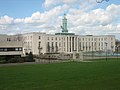 ウォルサムストウの役所
 -
 エリザベス女王の狩猟ロッジ
 -
 ウォルサムストウ競技場
 -
 レイトンの役所
 -
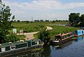 ウォルサムストウ湿地
 -
 レイトンストーン駅
 -
 ボーモント団地


脚注[編集]
(一)^ 2011 Census: Ethnic group, local authorities in England and Wales, Office for National Statistics (2012). 2011年の国勢調査に使われた設問などについては、英語版Classification of ethnicity in the United Kingdomを参照。
(二)^ 阿部孝夫 "先進諸国における地方自治システム" ﹃地域政策研究﹄第2巻 第1・2合併号 高崎経済大学地域政策学会 1999年10月 2018年6月21日閲覧
(三)^ ザ・ウォルサム・フォレスト・ガーディアン紙“Teenage twins in bid to take over theatre” サラー・コスグローヴ
(四)^ en。2000年代以降、特に2010年代以降のイギリスの中等教育政策において、国公立の私立化の過程で設置されたインデペンデント・スクールの一種。2022年1月現在、約80%の中等学校がアカデミーに転換している。
(五)^ Town twinning - ウォルサム・フォレスト議会ウェブサイト
外部リンク[編集]
| 全般 |
|
|---|---|
| 国立図書館 |
|
| 地理 |
|