エルサレム旧市街


エルサレム旧市街︵エルサレムきゅうしがい、英語: the Old City of Jerusalem; アラビア語: البلدة القديمة, al-Balda al-Qadimah; ヘブライ語: הָעִיר הָעַתִּיקָה, ha-ir ha-atiqah︶は、パレスチナ︵現在はイスラエル占領下のパレスチナ自治区・東エルサレム地区︶、エルサレム市中にある旧市街。面積は0.9km2で、城壁に囲まれている[1]。1860年代までは、この旧市街がエルサレムの全体であった。
エルサレムはアブラハム/イブラーヒームの宗教における重要な聖地・史跡を含んでいる。ユダヤ教徒にとっての神殿の丘と嘆きの壁、キリスト教徒にとっての聖墳墓教会、イスラム教徒︵ムスリム︶にとってのアル=アクサー・モスクと岩のドームなどである。これらのランドマークと旧市街全体は、1981年に﹃エルサレム旧市街とその城壁群﹄の名称で世界遺産として登録された[2]。
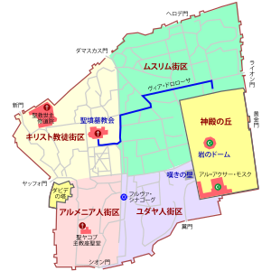
伝統的に、旧市街は19世紀になって導入された4つの区画に分けられている[3]。ムスリム街区、キリスト教徒街区、ユダヤ人街区、アルメニア人街区である。また、かつてはシリア人街区[注 1]もあったが、ユダヤ人街区に編入された。
市壁の歴史[編集]
紀元前11世紀にダビデ王がエルサレムを征服する以前には、この街はエブス人の本拠地だった。聖書は、この街が堅固な壁に守られた重厚な城塞都市であったと描写している。ダビデ王が支配したことで﹁ダビデの町﹂(ヘブライ語: עיר דוד、ラテン文字表記: Ir David) として知られた当時の街は、現在の糞門外側の旧市街の壁の南東にあったと考えられている。 ダビデの息子のソロモン王は都市の壁を拡大した。その後、アケメネス朝ペルシャ帝国領時代の紀元前440年頃、ネヘミヤがバビロンから戻り、市壁を再建した。西暦41年から44年にかけては、ユダヤの王アグリッパ1世が﹁第三の壁﹂として知られる壁を建造した。 1219年に、市壁はアイユーブ朝ダマスクスのクルド系アミールのアル=ムアッザム・イーサーによって完全に破壊された[4] 。1229年にはエジプトとの条約によって、エルサレムは神聖ローマ皇帝フリードリヒ2世の手に渡った。1239年には市壁の再建が始まったが、壁はイーサーの息子でケラクのアミール、アン=ナースィル・ダウドによって再び破壊された[5]。 1243年にエルサレムは再びキリスト教国エルサレム王国の勢力下に入り、市壁も修復された。しかし、翌年にはホラズムが都市を陥落し、市壁をまたも破壊した︵1244年のエルサレム攻囲戦︶。これによって、彼らは都市を無防備に置くという大打撃を与える形になった。 現存する旧市街の市壁は、オスマン帝国の皇帝スレイマン1世によって1538年に建造されたものである。長さは約4.5 km、高さは5 - 15 m、厚さ3mになる[6]。 全体では、旧市街の市壁は43の見張り塔、11の門︵うち7つは現在開放されている︶を含んでいる。街区[編集]


ムスリム街区[編集]
詳細は「en:Muslim Quarter (Jerusalem)」を参照
ムスリム街区は旧市街の北東端に位置し、4街区のなかで最も大きく、人口の多い街区である。ライオン門やヘロデ門があり、神殿の丘の北壁と接している。
他の3つの街区のように、ムスリム街区も1929年の嘆きの壁事件まではユダヤ人、キリスト教徒、ムスリムなどが混然と暮らしており、かつては「雑多な街区」と呼ばれていた。今日のムスリム街区には60世帯のユダヤ人家族が暮らしていて、Ateret Cohanimのようなイェシーバーもいくつかはある。
キリスト教徒街区[編集]
詳細は「en:Christian Quarter」を参照
キリスト教徒街区は、旧市街の北西端に位置している。ヤッフォ門でアルメニア人街区と接し、北の新門まで伸びている。このラインが東のダマスカス門まで延びており、ここがムスリム街区との境界になっている。
イエス・キリストが十字架を背負って歩いたとされる﹁悲しみの道﹂︵ラテン語: ヴィア・ドロローサ︶がある。キリスト教徒の巡礼者や修道士たちが、大きな木の十字架を背負いながら、イエスの受難の足取りを辿る﹁十字架の道行き﹂がしばしば行われる。イエスが十字架の重みに耐えかねてつまずいた場所、人ごみの中に聖母マリアの姿を見つけた場所、そしてイエスが手を突いた壁など、巡礼者はイエスの追体験をする。﹁悲しみの道﹂の終着点に、キリスト教徒たちにとって最大級の聖地のひとつ、聖墳墓教会がある。
「パレスチナのキリスト教」も参照
アルメニア人街区[編集]
詳細は「en:Armenian Quarter」を参照
アルメニア人街区は、旧市街の四つの街区の中では最小である。アルメニア人のほとんどはアルメニア使徒教会の+信徒を中心とするキリスト教徒ではあるが、キリスト教徒街区とは区別されている。この街区は面積・人口とも小さなものではあるけれども、アルメニア人とその総主教座は断固として独立を保ち、旧市街の中で力強い存在感を示している。
「聖ヤコブ主教座聖堂」も参照
1948年の第一次中東戦争以降、4つの街区はヨルダンの管轄下に置かれた。ヨルダンの法では、アルメニア人や他のキリスト教徒たちに、キリスト教系の私立学校において、聖書にもクルアーンにも均等な時間を割り当てることを要請し、かつ教会資産の拡大を制限した。
アルメニア人の修道院から2発の不発弾が見つかってからは、1967年の第三次中東戦争は、街区の住民たちから﹁奇跡﹂として思い起こされるようになった。
今日、エルサレムには3000人以上のアルメニア人が住んでいるが、そのうち500人が旧市街のアルメニア人街区で暮らしている。中には、神学校で学んだり、教会業務に従事するための一時的な居住者もいる。総主教座はこの街区に領地を持つとともに、西エルサレムなどに高価な財産を所有している。
1967年の第三次中東戦争の後に、イスラエル政府は戦争で損害を受けた教会や神聖視された遺跡の修復のために、その損害がどの陣営によるものかを問わず、修復のための補償を行った。
1975年にアルメニア人街区に神学校が建設された。
ユダヤ人街区[編集]
詳細は「en:Jewish Quarter (Jerusalem)」を参照
ユダヤ人街区︵ヘブライ語: הרובע היהודי, HaRova HaYehudi or the Rova︶は、旧市街の南東部に位置している。シオン門からのラインでアルメニア人街区と区切られており、嘆きの壁があり、神殿の丘の西に接している。
この街区は紀元前8世紀以来のユダヤ人たちの断続的な存在によって、実に豊かな歴史的経験を重ねてきた。
1948年にはおよそ2000人いたユダヤ人たちは包囲の上で集団退去を命じられ、歴史あるシナゴーグ群も破壊された。この街区はトランスヨルダンの支配下にあったが、1967年にイスラエル軍の落下傘部隊によって陥落した。その後、シリア人街区[注 1]の大部分を破壊してユダヤ人街区を拡張し、数百人のシリア系キリスト教徒︵アッシリア人︶を追放した[7]。
それ以降は再建も進み、2004年には2348人の住民を数えるまでになっており[1][リンク切れ]、多くの教育施設も設立されている。
再建される前にはヘブライ大学の考古学者Nahman Avigadの監督下で、発掘調査も行われた。考古学の遺物は一連の博物館に陳列されているほか、現在の市街よりも2、3階分低いところにある野外公園に陳列されており、世界的に見ても屈指のアクセスの容易さを誇る遺跡発掘現場となっている。
門[編集]
十字軍によって立てられたエルサレム王国時代には、旧市街には4つの門があった。スレイマン1世によって現存する市壁には、全部で11の門があるが、開いているのはそのうち7つのみである。1887年までは、どの門も日没前には閉じられ、日の出とともに開かれた。以下の表に示されているように、歴史的な時期や、共同体のグループごとに様々な異称がある。開いている門[編集]
| 日本語 (ヘブライ語) |
異称 | 建造年 | 位置 | |
|---|---|---|---|---|

|
新門 Sha'ar HeHadash |
Gate of Hammid, Al-Bab al-Jedid | 1887年 | 北側の西 |

|
ダマスカス門 Sha'ar Shkhem |
Sha'ar Damesek, Nablus Gate, Bab al'Amoud- Gate of the Pillar | 1537年 | 北側の中央 |

|
ヘロデ門 Sha'ar HaPerachim |
Flower Gate, Sha`ar Hordos, the Sheep Gate, Bab-a-Sahairad | 不明 | 北側の東 |

|
ライオン門 Sha'ar HaArayot |
Gate of Yehoshafat, St. Mary's Gate--Bab Sitt Maryam, St. Stephen's Gate, Gate of the Tribes | 1538年-1539年 | 東側の北 |
| 糞門 Sha'ar HaAshpot |
Gate of Silwan, Mograbi Gate, Sha`ar HaMugrabim, Bāb al-Maghāriba | 1538年-1540年 | 南側の東 | |

|
シオン門 Sha'ar Tzion |
Gate of the Prophet David, Gate to the Jewish Quarter | 1540年 | 南側の中央 |
| ヤッフォ門 Sha'ar Yaffo |
Bab al-halil--Hebron Gate, The Gate of David's Prayer Shrine, Porta Davidi | 1530年-1540年 | 西側の中央 | |
閉じられている門[編集]
| 日本語 (ヘブライ語のラテン文字表記) |
異称、説明 | 建造年 | 位置 | ||
|---|---|---|---|---|---|
| 黄金門 Sha'ar HaRahamim |
慈悲の門、永遠の命の門 | 6世紀 | 東側の中央 | ||
| Single Gate | この門は、神殿の丘の地下に繋がっている。 | ヘロデ王の時代 | 神殿の丘の南の壁 | ||
| フルダ門 Sha'arei Chuld |
三重門 | 東側の門。3つのアーチを持つ。 | |||
| 二重門 | 西側の門。2つのアーチを持つ。 | ||||
門の歴史[編集]
●ヤッフォ門 ヤッフォ門の隣の壁には裂け目がある。これは、ドイツ皇帝ヴィルヘルム2世の側近のために開けられたものである。側面に小さな門が付いている古代ローマ時代の大門は、ダマスカス門の通りよりも低いところで見ることが出来る。 ●ライオン門 スレイマン1世の夢見に因むという伝説がある。それによれば、彼はもし旧市街の市壁を再建しなければ、ライオンに食べられてしまうという夢を見たとされる。彼はこのことを記念して、門のひとつに二頭のライオンを刻むよう命じたという。これらの獅子は今日でも見ることが出来る。 ●新門 新門は1889年に遡るものである。この年に、フランス人のカトリック聖職者が、スルタンのアブデュルハミト2世に、キリスト教徒街区へのアクセスを容易にするために、聖母修道院の向かい側の壁を切り開くよう頼んだのである。 エルサレムが東西に分断されていた19年間は、新門はブロックされ、そこにヨルダンの軍事前哨拠点が築かれた。 ●フルダ門 フルダ門群と呼ばれる一連の閉鎖された門が南の壁の発掘現場から見ることができる。ヘロデ王の時代に遡るこれらの門︵単門、二重門、三重門︶は、第二神殿を訪れた巡礼者たちに使われた。 これらの門は十字軍の時代にまで市壁にあり、神殿の丘の地下に繋がっていた。その一つが神殿建造物に入るのに使われ、残りは出るのに使われた。 今日、神殿の丘にはBab el-Kattaninのような旧市街内部の門からもアクセスできる。世界遺産[編集]
| |||
|---|---|---|---|
 | |||
| 英名 | Old City of Jerusalem and its Walls | ||
| 仏名 | Vieille ville de Jérusalem et ses remparts | ||
| 登録区分 | 文化遺産 | ||
| 登録基準 | (2), (3), (6) | ||
| 登録年 | 1981年(第1回臨時委員会) | ||
| 危機遺産 | 1982年 - | ||
| 備考 | ヨルダンによる申請。 | ||
| 公式サイト | 世界遺産センター(英語) | ||
| 地図 | |||
| 使用方法・表示 | |||
﹁エルサレム旧市街とその城壁群﹂は、ユネスコの世界遺産登録物件のひとつ。周辺情勢の不安定さから保護が必要な物件である一方、エルサレムの帰属問題などのデリケートな問題をはらんでいることから、ヨルダンによる申請という変則的な手続きが認められた珍しい物件である。1981年の第1回臨時世界遺産委員会で登録が決定された。臨時委員会で登録が決定した物件は、第18回臨時委員会︵2023年︶でオデーサ歴史地区ほか2件が登録されるまで、他に見られなかった。1982年に危機遺産リストに加えられた。最も長い期間危機遺産リストに登録され続けている物件である。
登録基準[編集]
この世界遺産は世界遺産登録基準のうち、以下の条件を満たし、登録された︵以下の基準は世界遺産センター公表の登録基準からの翻訳、引用である︶。 ●(2) ある期間を通じてまたはある文化圏において、建築、技術、記念碑的芸術、都市計画、景観デザインの発展に関し、人類の価値の重要な交流を示すもの。 ●(3) 現存するまたは消滅した文化的伝統または文明の、唯一のまたは少なくとも稀な証拠。 ●(6) 顕著で普遍的な意義を有する出来事、現存する伝統、思想、信仰または芸術的、文学的作品と直接にまたは明白に関連するもの︵この基準は他の基準と組み合わせて用いるのが望ましいと世界遺産委員会は考えている︶。登録経緯[編集]
イスラエルはエルサレムを首都としているが、国際的には承認されていない。また、この物件の登録時点では、イスラエルは世界遺産条約を批准していなかった︵イスラエルの批准は1999年︶。そのため、この物件はエルサレムそれ自体の領有と切り離して、﹁ヨルダンによる申請﹂という注記で登録されることになった。 ユネスコ世界遺産センターの国別一覧[8]では、エルサレムは﹁エルサレム︵ヨルダンによる申請物件︶﹂として、どこの国にも属さない形で単独で扱われている。新世界の七不思議[編集]
アメリカのテレビ番組﹁グッド・モーニング・アメリカ﹂とUSAトゥディ紙が行った人気投票では、エルサレムの旧市街が﹁新・世界の七不思議﹂のひとつとして選ばれた。関連項目[編集]
脚注[編集]
注釈[編集]
(一)^ abここでいう﹁シリア人﹂とは、現在のシリア・アラブ共和国出身のアラブ人︵英: Syrian people︶という意味ではなく、アラム語系統の言語を用いるキリスト教徒である﹁アッシリア人﹂︵英: Syriac people, Syriacs︶のことを指している。
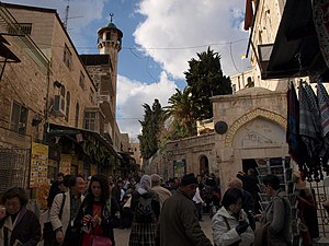
(二)^ 手前右の教会がアルメニア典礼カトリック教会のエルサレム=アンマン総大司教代理管区庁、手前左寄り・三日月印を冠したミナレット︵尖塔︶がイスラム教のモスク、中央遠方に見えるハヌッキーヤー︵八枝燭台︶の印がユダヤ教のシナゴーグ。ムスリム街区を貫通する﹁ヴィア・ドロローサ﹂の一角。
(三)^ アラビア語で預言者モーセという意味の地名、また同語源でムスリムによる祭礼と巡礼の名称。東方教会における聖金曜日の前の金曜日から1週間に亘って執り行われ、エルサレムから集団巡礼が出発する。
出典[編集]
(一)^ Kollek, Teddy (1977). “Afterword”. In John Phillips (英語). A Will to Survive - Israel: the Faces of the Terror 1948-the Faces of Hope Today. New York: Dial Press/James Wade. ISBN 978-0-8037-0176-2. "about 225 acres"
(二)^ “Old City of Jerusalem and its Walls” (英語). 世界遺産センター. ユネスコ. 2024年4月28日閲覧。
(三)^ Ben-Arieh, Yehoshua (1984). Jerusalem in the 19th Century, The Old City. Yad Izhak Ben Zvi & St. Martin's Press. pp. 14. ISBN 0312441878
(四)^ Grabar, Oleg; Ḳedar, B. Z. (2009). Where Heaven and Earth Meet: Jerusalem's Sacred Esplanade. University of Texas Press. pp. 163–171. ISBN 978-0-292-72272-9. "In 1198, al-‘Adil had his second son, al-Malik al-Mu'azzam ‘Isa, invested as ruler of Damascus, a position that included responsibility for Jerusalem."
(五)^ Hawari, Mahmoud (2013). “Capturing the Castle: Archaeology, Architectural History and Political Bias at the Citadel of Jerusalem” (英語) (PDF). Jerusalem Quarterly 55: 55.
(六)^ Zaun-Goshen, Heike. “Keys to the Treasure Trove - Jerusalem's Old City Gates”. Jerusalem Post. 2007年7月10日閲覧。[リンク切れ]
(七)^ Shams, Alex (2017年2月17日). “Yacoub Shaheen, the Assyrian singer from Palestine taking Arab Idol by storm”. Ajam Media Collective. 2021年9月27日閲覧。︵英語︶
(八)^ “UNESCO World Heritage Centre - World Heritage List” (英語). 世界遺産センター. ユネスコ. 2024年4月28日閲覧。

