
カーペンタリア湾
座標: 南緯13度45分 東経139度00分 / 南緯13.750度 東経139.000度
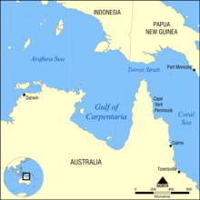
位置

カーペンタリア湾
カーペンタリア湾︵カーペンタリアわん、Gulf of Carpentaria︶とはオーストラリア北方にある湾。西はアーネムランド(Arnhem Land)、東はヨーク岬半島に挟まれており、北側はアラフラ海に繋がっている。広く浅い湾であり、東西の長さは湾口において590㎞、最大となる南緯15°付近では675㎞であって、湾口から湾奥までの長さはおよそ700㎞である。水深は概ね60m、最深部でも約80mほど[1]で、水域面積は約30万平方メートル。湾内の干満差は2メートルから3メートルである。


地理[編集]
湾内には、西部に最大のグルートアイランド島、サーエドワードペリュー諸島︵en:Sir Edward Pellew Group of Islands︶、南部にウェルズリー諸島などの島がみられる。また、ミッチェル川︵en:Mitchell River︶、ギルバート川︵en:Gilbert River︶、フリンダーズ川などが流入する。 湾周辺の気候は、4月から11月までの明瞭な乾季があるサバナ気候。乾季は、オーストラリア大陸内陸部の高気圧に起因する、乾燥した南東~東よりの風に特徴づけられる。12月から3月の雨季にはサイクロンによる被害を受けやすく、年間降雨の大部分が集中し、沿岸部に洪水を引き起こす。年に平均して3回のサイクロンの襲来によって、湾内の堆積物が時計回りに攪拌されていると考えられている[2]。 湾岸には大分水嶺山脈のような、降水の多い地域を狭い範囲に限定する山地が存在しないため、大陸の他の地域とは異なり、湾岸から内陸への降水量の変化は緩やかとなっている。 9月と10月には巨大な帯状の雲が空を横切るモーニング・グローリー︵en:Morning Glory cloud︶という気象現象が夜明け後しばらくして発生し、湾奥のバークタウン︵en:Burketown︶地域でよく観察される。 湾内の湿地帯には、マングローブが繁茂する。2017年には、広い面積で枯死していることが確認されている[3]。 1万8000年前の最終氷期の最盛期には、湾は大きく干上がり、中央部に湖が存在した[4]。また紀元536年には小惑星の衝突があったとの仮説が出されている[5]。歴史[編集]
初めて探検したヨーロッパ人はオランダのWillem Janszoon︵Janszとも︶で1606年のことである。1623年に仲間のJan Carstenszoonが訪れ、時の東インド会社総督に因んでカーペンタリア湾と名付けた。タスマニア島を発見したアベル・タスマンも2年後の1644年に探検している。 1860年から1861年にかけて、オーストラリア大陸縦断を初めて成功させたバーク・ウィルズ探検隊が内陸側から初めてカーペンタリア湾に達している。ただし、マングローブに覆われた湿地帯を突破できず、塩分を含んだ水と干満の差を確認して撤退している。脚注[編集]
- ^ http://permanent.access.gpo.gov/websites/pollux/pollux.nss.nima.mil/NAV_PUBS/SD/pub175/175sec01.pdf
- ^ David Hopley; Scott Smithers (2010). "Queensland". In Eric C.F. Bird (ed.). Encyclopedia of World's Coastal Landforms. Springer. p. 1255. ISBN 978-1-4020-8638-0。
- ^ 豪マングローブ林、7400ヘクタールが枯死 史上最大規模 AFP(2017年3月14日)2017年3月25日閲覧
- ^ Torgersen, T., Hutchinson, M.F., Searle, D.E., Nix, H.A., 1983. General bathymetry of the Gulf of Carpentaria and the Quaternary physiography of Lake Carpentaria. Palaeogeogr., Palaeoclimatol., Palaeoecol. 41, 207-225
- ^ Richard A. Lovett (3 February 2010). Giant Meteorites Slammed Earth Around A.D. 500?. National Geographic News. National Geographic Society. Retrieved 3 March 2013.
| 全般 |
|
|---|---|
| 国立図書館 |
|