
ファンディ湾

ファンディ湾

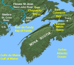
ファンディ湾の位置(カナダ ノバスコシア州)
ファンディ湾︵ファンディわん、英語: Bay of Fundy、フランス語: Baie de Fundy︶は、北アメリカの大西洋岸にある湾。
概要[編集]
メイン湾の北東端、カナダのニューブランズウィック州とノバスコシア州の間に位置し、ごく一部はアメリカ合衆国のメイン州にも面している。 ファンディ湾は潮の干満が激しいことで知られ、干満差世界一の座をケベック州のアンガヴァ湾やイギリスのセヴァーン川河口と競っている。名称[編集]
﹁ファンディ﹂という名称は、16世紀にポルトガル人たちがこの湾を Rio Fundo︵深い川︶と呼んだことに由来すると考えられている。 この湾はまた、探検家サミュエル・ド・シャンプランが1604年に訪れた際にフランス湾︵Baie Française︶と名付けられていた。潮汐[編集]
 |
 |
先住民のミクマク族の民間伝承では、ファンディ湾の潮の干満は、水の中で跳ね回る巨大なクジラによって起こされていると伝えられる。
海洋学者は、干満の原因を潮の共鳴によるものとしている。これは、大きな波が湾の入口から端まで移動してまた戻る時間と、潮の干満の時間が同じことに由来する。12.4時間の間に、1,150億tもの水が湾を出入りし[1]、干満差は15mにも及ぶ。
干満差の調査が進んだ結果、ファンディ湾奥部のミナス湾︵または﹁マイナス湾﹂、Minas Basin︶と、アンガヴァ湾奥部のリーフ湾︵Leaf Basin︶との間で、潮の干満差世界一を巡って競い合っている。
ファンディ湾周辺の地理

ノバスコシア半島から眺めたファンディ湾

5月初頭のファンディ湾
ファンディ湾の奥部は二股に分かれており、北東側がシグネクト湾︵Chignecto Bay︶、東側がミナス湾︵Minas Basin︶となっている。シグネクト湾はさらにカンバーランド湾︵Cumberland Basin︶とシェポディ湾︵Shepody Bay︶に分かれ、ミナス湾の最東部はコベクイド湾︵Cobequid Bay︶と呼ばれる。これら最奥部では赤い湾泥︵bay mud︶がむき出しになっていることがある。この湾泥の外見や生物学的生産性の面も注目されている。
シグネクト岬︵Cape Chignecto︶がシグネクト湾を、スプリット岬︵Cape Split︶がミナス湾の入口となるミナス海峡を区切っている。
ファンディ湾の湾口部にも4つの主要な支湾が存在する。ニューブランズウィック州の沿岸にパサマクウォディ湾︵Passamaquoddy Bay︶とバック湾︵Back Bay︶、メイン州沿岸にコブスクック湾︵Cobscook Bay︶、そしてノバスコシア州沿岸にアナポリス湾︵Annapolis Basin︶がある。
海嘯
湾の極端に大きな潮の干満差は、そこへ流れ込む多くの河川にいくつかの興味深い現象を引き起こしている。
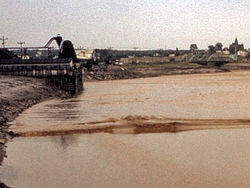
セント・ジョン川では満潮時に逆流が見られ、セント・ジョン市の中ほどで川が湾に流れ込む場所に存在する有名なリバーシング・フォールズ︵Reversing Falls︶で急流を起こしている。
ファンディ湾奥に位置する河川はセント・ジョン川よりも流れの規模が小さく、傾斜も浅くなっている。その結果、河川内の潮の届く範囲に広大な泥干潟が形成されている。
これら湾奥部の河川で起こるもうひとつの現象が﹁海嘯﹂で、これは上げ潮によって川の流れが完全に逆流する現象である。海嘯の顕著な例の一つはトゥルーロ︵Truro︶の町とメイトランド︵Maitland︶の村の近くを流れるシュブナカディー川で見られ、ここでは地元のエコツーリズムの企画者たちが逆流する波の上でのラフティングを経験する機会を提供している。もう1ヶ所海嘯がよく見られる可能性があるのが、トゥルーロの町中を流れるサーモン川である。かつては有名であったペティコーディアック川とエイヴォン川の海嘯は、1960年代から1970年代にかけて土手道︵causeway︶の建設が原因で沈泥が過度の堆積を起こし、きわめて小規模なものとなった。
潮力発電[編集]
ここ数十年間、ファンディ湾に潮力発電を建設する計画が進められた。主な内容は、湾内の小さな入り江を堰で仕切り、そこを通る水の力を発電に利用するというものである。 こうした設備のうち、現在唯一稼働中であるアナポリス・ロイヤル発電所︵Annapolis Royal Generating Station︶がノバスコシア州アナポリス・ロイヤルを流れるアナポリス川︵Annapolis River︶に堰と18メガワットの発電所を有しているが、これ以上の規模の計画は環境問題を含むさまざまな要因により進んでいない。地理[編集]
ファンディ湾は、約1億9千万年前に超大陸パンゲアが分裂し始めた頃に形成された地溝︵リフト・バレー︶である。リフト︵rift︶が北アメリカ大陸から分かれ始めるにつれて火山活動が起こり、火山や洪水玄武岩を形成した。この洪水玄武岩は、ノバスコシア州南部の大部分において、いたるところに露出している。洪水玄武岩の一部は侵食によって失われたが、現在もノース・マウンテン︵North Mountain︶という玄武岩質の山脈を形成している。結果として、湾の底部の大部分は褐色の色を示すソレアイト質玄武岩︵tholeiitic basalt︶で構成されている。地溝は、大西洋中央海嶺が北アメリカ・ヨーロッパ・アフリカを分裂させてゆくにつれて、最終的には失われた。 ファンディ湾周辺一帯にはアカディの混交林、複雑な海岸線、塩性湿地と干潟があり、内陸部には滝、急流、断崖と峡谷も見られる。湾付近の湿地一帯にはスパルティナ属などの植物が生え[2]、ハクトウワシ、カナダオオヤマネコ、ピューマ、シノリガモ、ハヤブサ[3]、海生端脚類のCorophium volutator、ヒレアシトウネン、アメリカヒバリシギなどの動物が生息している[4][5][6]。 湾奥西側のセントマーティンからタントラマー沼地まで至る一帯は2007年にユネスコの生物圏保護区に指定され[3]、2020年にミナス湾北岸一帯は﹁ファンディ・クリフユネスコ世界ジオパーク﹂に指定された[7][8]。また、﹁メアリーズ・ポイント﹂[4]﹁シェポディ湾﹂[5]﹁シグネクト湾﹂[2]と﹁ミナス湾﹂[6]の4カ所はラムサール条約登録地である。支湾[編集]


島[編集]
湾内にはいくつかの島が存在する。最も大きなものはメイン湾との境界に位置するグランド・マナン島︵Grand Manan Island︶である。ほかに主要な島としては、パサマクウォディ湾内にカンポベロ島︵Campobello Island︶、ムース島︵Moose Island︶、ディア島︵Deer Island︶がある。湾の南部にはブライアー島︵Brier Island︶やロング島︵Long Island︶があり、他方でシグネクト岬の奥にはオート島︵Isle Haute︶がある。さらに小さな小島はパサマクウォディ湾やバック湾、アナポリス湾などに存在する。ミナス湾内のファイブ・アイランズ︵Five Islands︶は特に景勝地として知られる。河川[編集]
ファンディ湾にはいくつかの河川が流入している。主なものとしては以下のものがある‥ ●ニューブランズウィック州 ●マッカーデイヴィック川︵Magaguadavic River︶ ●メムラムクック川︵Memramcook River︶ ●ペティコーディアック川︵Petitcodiac River︶ ●セント・ジョン川︵Saint John River︶ ●セント・クロア川︵St. Croix River︶ ●シェポディ川︵Shepody River︶ ●タントラマー川︵Tantramar River︶ ●ノバスコシア州 ●アナポリス川︵Annapolis River︶ ●エイヴォン川︵Avon River︶ ●コーンウォリス川︵Cornwallis River︶ ●ファレルス川︵Farrells River︶ ●サーモン川︵Salmon River︶ ●シュブナカディー川︵Shubenacadie River︶