ハドソン湾


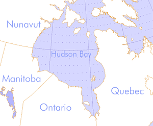
ハドソン湾︵ハドソンわん、英語: Hudson Bay、フランス語: baie d'Hudson︶は、カナダ北東にある面積123万平方kmにおよぶ大きな湾。その水深は比較的浅い。西経78度から95度、北緯51度から70度までの範囲に広がる。島が多く、多島海のひとつ。
湾内にはオタワ諸島、ベルチャー諸島、アキミスキ島などの島があり、全てヌナブト準州に属している。ハドソン湾の南部、オンタリオ州とケベック州の境に向かってジェームズ湾が切れ込んでいる。また東はハドソン海峡で大西洋に、北はフォックス海峡とローズウェルカム海峡からフォックス湾などを経て、北極海と繋がっている。国際水路機関︵IHO︶はハドソン湾を北極海の一部に分類している。
ハドソン湾に注ぐ河川のうち大きなものは東のケベック州から注ぐラ・グランド川および、ウィニペグ湖から発しマニトバ州を流れる西のネルソン川︵支流‥ノースサスカチュワン川、サウスサスカチュワン川、サスカチュワン川、ボウ川、レッド川︶、およびチャーチル川である。また南のオンタリオ州からはジェームズ湾にオールバニー川、ムース川などが流れ込んでいる。ハドソン湾に流れる水系の流域は北アメリカ大陸の中央部からハドソン湾を取り囲む島々に広がり、面積は390万平方kmに及ぶ。カナダ国土の半分ほど︵ケベック州とオンタリオ州の北側の大部分、マニトバ州とサスカチュワン州のほとんど、アルバータ州の南半分、ヌナブト準州の南東部︶とアメリカ合衆国の一部︵ノースダコタ州、ミネソタ州︶も含む。
ハドソン湾という名前は、1610年に湾を探検したヘンリー・ハドソン︵Henry Hudson︶にちなんでつけられた。先住民の東部クリー語ではハドソン湾を﹁泥の水﹂という意味の﹁Wînipekw﹂︵南部方言︶または﹁Wînipâkw﹂︵北部方言︶という。ウィニペグ湖︵Lake Winnipeg︶と語源は同様である。

ルパート・ランド
60年後の1668年にイギリス船ノンサッチ号︵Nonsuch︶が湾内に入り、沿岸のクリー系民族らとビーバーの毛皮を交易することに成功した︵それまでハドソン湾沿岸の良質の毛皮は、先住民同士の交易で南へ渡り、五大湖周辺で活動するフランス商人が独占的に扱っていた︶。これがきっかけで1670年にハドソン湾会社︵Hudson's Bay Company︶が成立した。ハドソン湾会社は、ハドソン湾および湾に流れ込む河川の流域全土︵ルパート・ランド Rupert's Land︶における交易の独占を勅許された。フランスはこれに対し何度も軍隊を送り対抗したが、1713年4月のユトレヒト条約でルパート・ランドに対する主張を放棄した。
ハドソン湾会社は多くの砦や交易所を、湾岸の大きな河川の河口付近に設けた︵オンタリオ州のフォート・セヴァーン Fort Severn、マニトバ州のヨーク・ファクトリー York Factory やチャーチル Churchill など︶。これらの戦略的要所に設けられた拠点はルパート・ランドの内陸探検の基地となり、また河川を伝って往来する先住民たちとの毛皮交易の場ともなった。ハドソン湾会社はこれら毛皮を、モントリオールなどを経由せず最短距離でヨーロッパへ直送し、巨利を得た。これらの交易所は20世紀初頭まで使用された。ハドソン湾会社は Hudson's Bay Company と表記されたが、ハドソン湾自体は Hudson Bay が正式名称となっている。このため、湾名や会社名はしばしば混同された上で誤記されている。
ルパート・ランドはハドソン湾会社と北西会社との合併によりさらに北極海方面へ拡大したが、1870年にハドソン湾会社の独占権は撤廃され、ルパート・ランドはカナダのノースウェスト準州の一部となった。

ハドソン湾は11月には凍結する。チャーチル川付近で氷を渡るホッキョ クグマ
オンタリオ州北部など、湾の西部沿岸は﹁ハドソン湾低地︵または、ジェームズ湾西方の低地も含めハドソン・ジェームズ低地︶﹂と呼ばれ、その面積は32万4,000平方kmにおよぶ。これら低地は多くの川が流れる湿地となっており、低木のほかトウヒやポプラが生えるマスケグ︵ムスケグ、muskeg︶と呼ばれる特異な泥炭地になっている。この泥炭地は、北のツンドラと南のタイガ︵針葉樹林︶との移行地域である。湾周辺の土地は長年の氷河による侵食や湾の縮小により削られた跡がある。内陸部には、かつて湾が広い時期の海岸線だった地形が多く残っている。こうした泥炭地は岩盤が地下深くにあり、地表はぬかるむ湿地や無数の湖沼が主で夏は大量の虫が舞うため、家屋・道路の建設に適さず手つかずの自然が残っている。
ハドソン湾低地にはオンタリオ州のポーラー・ベア州立公園、マニトバ州のワプスク国立公園︵wapusk とはクリー語で﹁ホッキョクグマ﹂の意味︶がある。この周辺の泥炭地は、ホッキョクグマが棲むほか、ムース、カリブー、ホッキョクギツネ、フクロウ、ハヤブサなどの多様な生物が生きる。海中にはワモンアザラシやセイウチ、ベルーガやイッカクやホッキョククジラなどがおり、とくにアザラシはホッキョクグマの貴重な食料となる。近年は、温暖化の影響からか流氷の量と凍結時間が減っており、たとえばザトウクジラやミンククジラ、シャチなどがより進出してきている。[1]
反対に、湾の東のケベック側海岸︵ラブラドル半島、およびその北部のアンガヴァ半島︶は、カナダ楯状地の縁に当たっており、岩が多く丘が連なっている。植生はタイガとなっており、さらに北はツンドラになっている。

氷床の消失によるリソスフェア上昇の割合︵2007年の調査︶
20~18億年前の原生代にこの地域でハドソン横断造山運動 (Trans-Hudson orogeny)と呼ぶ大規模な大陸衝突が生じた。その後カンブリア紀は陸地であったが、オルドビス紀に海となり、シルル紀に再び隆起運動が起こり、デボン紀には陸現物を多く含む浅海堆積物が形成された。
1960年代に地球の重力場を地図化し始めた時、ハドソン湾に広大な低重力が観測された。最終氷期のローレンタイド氷床による地殻の圧縮が続いているためと当初考えられたが、GRACE人工衛星による詳細な観測で、それだけが重力異常の原因でなく、マントル対流に起因することが分かった。現在の観測では、湾を中心とした地域は年間に17mmと、氷床消失による地殻の上昇が世界でも最も大きい地域となっている。
湾の南東部には半円形の海岸線︵ナスタポカ諸島弧︶と、それに沿うように湾内にベルチャー諸島が並んでいる。クレーターを想起させるこの地形の成因については、月面の危難の海との比較により先カンブリア時代に起きた地球外天体の衝突の衝撃によってハドソン湾が形成されたと主張する地質学者もいたが、現在においてなお地磁気や重力異常など地質学的に確実に衝突地形であるとされる証拠は発見されていない[2]。
歴史[編集]
ヘンリー・ハドソンは1610年8月、イギリス船ディスカバリー号︵Discovery︶でこの海域に達した。彼はイギリスやオランダの支援を受けながら三度にわたり北米大陸を迂回するアジアへの最短航路︵北西航路︶を見つけようとしたが、四度目の航海でついにグリーンランドの西海岸に出てハドソン湾まで達することができた。彼は湾内の地図製作や測量を行ったが、冬になると氷に閉じ込められ、ジェームズ湾で越冬した。春になって氷が解け始めると彼は西への航海を再開しようとしたが、厳しい航海と少ない備蓄に不満を募らせていた船員は1611年6月22日に反乱を起こし、ハドソンとその部下らは食料なしの小船で置き去りにされそのまま行方知れずとなった。
地理[編集]
気候[編集]
年間を通じ寒冷で、平均気温はマイナス5℃である。水温は西岸で夏に最高9℃で、12月から6月に湾は結氷しているが、最近100年間の気温上昇により、17世紀に4か月しかなかった融氷期間が延びてきた。水域[編集]
ハドソン湾は南北1,370km、東西1,050kmに広がり、最大水深270mである。世界の海洋に比べ、海水の塩分濃度が低い。これは、 (一)海水が余り蒸発しない︵年のほとんどの期間、海面が氷で覆われているため︶ (二)地表を通ってきた大量の水が湾に流れ込むため︵カナダの国土の相当部分の雨水はハドソン湾に流れる︶ (三)さらに毎年流氷が溶けるたびに、河川からの流入量の三倍の淡水が湾の表層に供給される (四)塩分濃度の高い大西洋との出入り口や海水のやり取りが少ない ことが理由に挙げられる。 表面が凍るのは12月中旬から6月中旬にかけて。海岸[編集]

島[編集]
ハドソン湾、特に東側の海岸付近には多くの島が浮かぶ。これらはすべてヌナブト準州の管轄に入っている。たとえば湾の南部、ケベック寄りにある比較的大きな群島、ベルチャー諸島︵Belcher Islands︶もその一つである。 湾の入り口は、世界有数の面積の大きな島々でふさがれている。主な島は、西から順にサウサンプトン島︵Southampton︶、コーツ島︵Coats︶、マンセル島︵Mancel︶があり、フォックス湾とハドソン湾を分けている。地質[編集]

湾岸の自治体[編集]
ハドソン湾岸にはほとんど住民がいない。町村の数はわずか1ダースほどであり、そのいくつかは17世紀末から18世紀にハドソン湾会社が設立した交易所が元になっている。ハドソン湾会社の交易所や経営する店舗が20世紀後半には閉鎖されており、住民の多くはクリー諸族やイヌイットである。 特に大きな町は以下の通り。 ●ケベック州プヴィルニトゥク︵Puvirnituq︶‥湾の北東部、イヌイットの1,300人弱の集落 ●ヌナブト準州ランキン・インレット︵Rankin Inlet︶‥湾の北西部、キヴァリク地域︵Kivalliq Region︶の中心 ●ヌナヴト準州アルヴィアット︵Arviat、旧名エスキモー・ポイント Eskimo Point︶‥湾の北西部、キヴァリク地域の町、人口2,060人︶ ●マニトバ州チャーチル︵Churchill︶‥湾の西部、チャーチル川河口。名はハドソン湾会社で17世紀末に総督を務めたマールバラ公ジョン・チャーチルにちなむ。軍事基地[編集]
東西冷戦が始まるまで、この地に軍事的重要性はなかった。1950年代、北極海を越えたソ連の攻撃に備え、ミッド・カナダ・ラインと呼ばれる防空レーダー網を構築するためレーダーサイトが北米大陸を横断するように設置され、この湾岸のいくつかの場所にもレーダーサイトがおかれた。注釈[編集]
- ^ Higdon W.J., Ferguson H.S., 2011 Reports of Humpback and Minke Whales in the Hudson Bay Region, Eastern Canadian Arctic. Northeastern Naturalist 18(3):370-377. BioOne Online Journals.
- ^ Eaton D. W. and F. Darbyshire, 2010, Lithospheric architecture and tectonic evolution of the Hudson Bay region. Tectonophysics. v. 480, pp. 1–22.
