
フィンランド多島海域
この項目﹁フィンランド多島海域﹂は翻訳されたばかりのものです。不自然あるいは曖昧な表現などが含まれる可能性があり、このままでは読みづらいかもしれません。︵原文‥英語版 "Archipelago Sea" 11:14, 3 April 2020 (UTC)︶
修正、加筆に協力し、現在の表現をより自然な表現にして下さる方を求めています。ノートページや履歴も参照してください。︵2020年5月︶ |
| フィンランド多島海域 Saaristomeri | |
|---|---|
| Skärgårdshavet、Archipelago Sea | |
 | |
 バルト海周辺におけるフィンランド多島海域の位置(赤枠)。ただし、この縮尺では島はほとんど見えない | |
| 位置 |
* * * |
| 座標 | 北緯60度18分 東経21度00分 / 北緯60.3度 東経21度座標: 北緯60度18分 東経21度00分 / 北緯60.3度 東経21度 |
| 種類 | 多島海 |
| 上位水域 | バルト海 |
| 国 |
|
| 面積 | 6,300平方キロメートル (2,432平方マイル) |
| 平均水深 | 23m[1] |
| 塩分濃度 | 0.6% |
| 島 | 約18,000[注釈 1] |
| 脚注 | [1] |
フィンランド多島海域︵フィンランドたとうかいいき、サーリストメリ︵フィンランド語: Saaristomeri︶、フェルゴールドシャーヴェット︵スウェーデン語: Skärgårdshavet︶、英語: Archipelago Sea︶は、ボスニア湾、フィンランド湾そしてオーランド海の間にある海域である。フィンランド領海に含まれる。いくつかの定義では、島の数においては世界で最多の多島海であるとされるが、多くの島々は非常に小さく密集している。フィンランド語やスウェーデン語を初め、英語などでも﹁多島海﹂や﹁群島海﹂を意味する名詞がこの海域を示す固有名詞として使用される。
海域内で大きな島は有人島であり、フェリーや橋で接続されている。海域の西側に位置するオーランド諸島は、この海域で最も大きな島を持つ諸島であり、フィンランド領であるが自治領として多くの権限を有している。残りの島のほとんどは南西スオミ県に属している。フィンランド多島海域は観光地としても著名である。
地理[編集]
フィンランド多島海域は大雑把に言って、マリエハムン︵オーランド諸島︶、ウーシカウプンキ︵南西スオミ県︶、ハンコ︵ウーシマー県︶を頂点とした三角形の海域の事を言う。この海域の群島は内と外の群島に分けることが出来、特に外群島の方が小さく無人の島が多い。この海域の面積は、8,300平方キロメートル (3,205平方マイル)であり、その内、2,000平方キロメートル (772平方マイル)が陸地である[2]。 この海域には非常に多くの島々が浮かんでいる。正確な数字は﹁島﹂の定義に依存するため、はっきりとしない。この海域には多彩な大きさの陸地が存在し、海から頭を出した岩から複数の小村や町を持つ大きなものまである。この海域内で、かつオーランド諸島と南西スオミ県内に所在する島の内、1km2以上の島々は257であり、これ以外に0.5haを超える陸地を持つ島々の数は約17,700になる[3]。もし人が住むことが不可能な岩や岩礁を含めた場合、50,000程度になるものと見積もられる[要出典]。他の海域の島の数と比較すると、北極諸島︵カナダ︶で36,563[要出典]、インドネシア海軍海洋観測局によればインドネシア全体で17,508[4]、フィリピンが7,107である[要出典]。 この島々の始まりは、最後の氷河時代の後に海から浮上し始めたものである。後氷期地殻均衡復元が未だに続いていることから、新たな岩礁や島が徐々に形作られており、古い島や岩礁は拡大し、場合によっては結合している。現在の島の隆起速度は1年間に4~10mmの間であるとされる[5]。島々はスヴェコフェニアン造山運動で形成された古代山脈の名残りであり、主に花崗岩と片麻岩から構成されており︵他には片岩と石灰岩もある︶、双方とも非常に硬い岩石であることから侵食は隆起の速度と比較してもかなり遅い[6]。しかしながら、フィンランド国内では南方に位置していることから、より北方にあるクヴァルケン群島︵スウェーデン語: Kvarken、メレンクルック群島︵フィンランド語: Merenkurkku︶︶の海域と比較すると地殻均衡復元の速度はゆっくりしたものとなっている。 この海域の水深は浅く平均水深は23m程度しかない[1]。そのため、ほとんどの海峡においては大きな船の航行は不可能である。 この海域内には3つのクレーター様の跡がある。その内の一つは、オーランド諸島のルンパルン湾︵スウェーデン語: Lumparn、フィンランド語: Lumpari︶であり、間違いなくクレーターであるとされる[7]。残りの2つは深成岩から構成されている。より大きなものは、ブレンド︵スウェーデン語: Brändö︶にあるオーヴァ︵スウェーデン語: Åva︶の痕跡であり、衛星写真や高解像度の地図でも見ることが出来る。もう一方の小さなものは、フーチェール︵スウェーデン語: Houtskär、ホウツカリ︵フィンランド語: Houtskari︶︶の主島とイニオ︵スウェーデン語: Iniö、フィンランド語: Iniö︶の間、フェルフェール︵スウェーデン語: Fjälskär︶に所在する[8]。行政[編集]
海域の島々は、南西スオミ県とオーランド自治県の間で分割されている。この分割線は、大雑把に言えばフィフテット︵スウェーデン語: Skiftet、キヒティ︵フィンランド語: Kihti︶︶に沿っている。スウェーデン沿岸に近い島々は、それらの沿岸地域とユーロリージョンを構成している。この海域のメインとなる本土側の港はトゥルクであり、オーランド諸島側はマリエハムンである。オーランド諸島[編集]
「オーランド諸島」も参照
オーランド諸島は、フィンランドの自治領︵オーランド自治県︶であり非武装化されている。独自の議会を持ち、スウェーデン語を唯一の公用語としている。この自治領の議会は、医療サービス、教育、環境、そして郵政を含む幅広い分野に対して決定権を持つ。財政や外交に関しては、フィンランド議会が権限を持っている。理論的には、フィンランドの大統領は、オーランド諸島の議会で可決された法律を拒否する権利を持っている[9]。
防衛[編集]
東側の群島の防衛は、かつてトゥルクに基地を構えるフィンランド多島海域海軍司令部︵フィンランド語: Saaristomeren meripuolustusalue︶が担っていた。主な防衛手段は、広域な機雷と沿岸砲によるものであった[10]。双方とも、小さな島々が高密度に存在するため、侵入してきた船舶の航路を大幅に制限することから、この海域では有効な防衛手法である。このフィンランド多島海域海軍司令部は2014年に組織再編にて消滅しており、現在この地域の防衛を担っているのはフィンランド海軍に新たに創設された沿岸艦隊である。一方で、オーランド自治県は非武装化されている。そのため、平時においてはフィンランド国防軍はオーランド自治県内への侵入を許されていない[注釈 2]。そのため、オーランド自治県の住民は徴兵制度のあるフィンランドでは例外的に兵役義務を免除されている。ただし、軍役に就くことを志願することは可能である。自治体[編集]
「フィンランドの地方自治体」も参照
この海域は、30の地方自治体に分割されており、それぞれオーランド自治県、南西スオミ県、ウーシマー県に属している。オーランド自治県の地方自治体は、かなり小規模なものになっている傾向が強く、例えばソットゥンガは、住民の数は約100人程度しかいない。
南西スオミ県の地方自治体︵島嶼部︶
●ケミオンサーリ︵フィンランド語: Kemiönsaari︶/キミトーン︵スウェーデン語: Kimitoön︶
●クスタヴィ︵フィンランド語: Kustavi︶/グスタフス︵スウェーデン語: Gustavs︶
●パライネン︵フィンランド語: Parainen︶/パルガス︵スウェーデン語: Pargas︶
南西スオミ県の本土側地方自治体の内、島嶼部を持つ自治体
●カーリナ︵フィンランド語: Kaarina︶/サント・カリンス︵スウェーデン語: S:t Karins︶
●マスク︵フィンランド語: Masku︶/マスコ︵スウェーデン語: Masko︶
●ナーンタリ︵フィンランド語: Naantali︶/ノーデンダル︵スウェーデン語: Nådendal︶
●ピュハランタ︵フィンランド語: Pyhäranta︶
●サロ︵フィンランド語: Salo︶
●サウヴォ︵フィンランド語: Sauvo︶
●タイヴァッサロ︵フィンランド語: Taivassalo︶
●トゥルク︵フィンランド語: Turku︶/オーボ︵スウェーデン語: Âbo︶
●ウーシカウプンキ︵フィンランド語: Uusikaupunki︶/ニュスタード︵スウェーデン語: Nystad︶
オーランド自治県の地方自治体
●ブランド︵スウェーデン語: Brändö︶
●エッケロー︵スウェーデン語: Eckerö︶
●フィンストロム︵スウェーデン語: Finström︶
●フォーグロー︵スウェーデン語: Föglö︶
●ゲタ︵スウェーデン語: Geta︶
●ハンマルランド︵スウェーデン語: Hammarland︶
●ユーマラ︵スウェーデン語: Jomala︶
●クムリンゲ︵スウェーデン語: Kumlinge︶
●コーカル︵スウェーデン語: Kökar︶
●レムランド︵スウェーデン語: Lemland︶
●ルンパルランド︵スウェーデン語: Lumparland︶
●マリエハムン︵スウェーデン語: Mariehamn︶
●サルトヴィーク︵スウェーデン語: Saltvik︶
●ソットゥンガ︵スウェーデン語: Sottunga︶
●スンド︵スウェーデン語: Sund︶
●ヴォールド︵スウェーデン語: Vårdö︶
ウーシマー県の本土側地方自治体の内、フィンランド多島海域の島嶼部を持つ自治体
●ハンコ︵フィンランド語: Hanko︶/ハンゲ︵スウェーデン語: Hangö︶
●ラーセポリ︵フィンランド語: Raasepori︶/ラーセボリ︵スウェーデン語: Raseborg︶
島々はウーシマー県東部へと更に続いていくが、ハンコが歴史的にフィンランド多島海域とフィンランド湾との境界となっている。
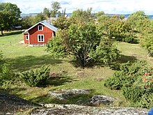
クロークフェール島は1956年まで有人島だった。この写真は201 0年に撮影したものである。小さな島々では、ある程度纏まって考えても多くて数世帯の家族しか生活することが出来なかった。また主な収入源も漁業しかなかった
この海域内の定住者の人口は約60,000人であり、内27,000人がオーランド諸島に居住している。オーランド諸島の領域外の地域においても幾分スウェーデン語が単一使用の地域が多いが、現在は公式にはスウェーデン語を母語とするバイリンガル地域となっている。その一方で、この地域の北部はフィンランド語の単一使用地域となっている。
フィンランド多島海域の人口は歴史の中で大幅に異なる。16世紀前半まではこの地域の人口は増加していた。しかし、この地域の環境の収容能力の限界に達したこと、戦争、疫病が原因となってこの地域の人口は減少に転じた。19世紀になると、新たにより効果的な漁業手法がもたらされたことで人口は顕著に増加した。20世紀に入ると人口は再び減少に転じた。これは特に小さな島々で顕著であり、急激な都市化が原因である。多くの小さな島々が完全な無人となった。最近10年の間に島々における夏季の間の滞在者人口は、いくつかの地域が活性化されたことにより増加している[11]。
この地域の自然の美しさが知られたことで、多くのフィンランド人がこの地域の島々で夏を過ごす様になった。これが原因となって、多くの島々の人口は夏季の間に限って元々の人口の2倍かそれ以上にも達することもある。スウェーデン語話者が多数の島々の中に別荘がある一方で、フィンランド本土ではスウェーデン語話者は少数派であり、この地域で夏季を過ごす人々の殆どがフィンランド語話者である。これはこの地域に定住している人々と対照的である。フィンランド大統領の公式別荘であるクルタランタは、この地域の島であるルオンノンマー島︵ナーンタリ市域︶に所在している[12]。
この地域の人口に関する他の特徴として、双子の数が挙げられる。二卵性双生児誕生の傾向が幾分遺伝しており、必要な遺伝子が島々の至る所にある。18世紀から19世紀において、双子誕生の傾向は他のヨーロッパの地域よりも強く、フィンランド本土と比較すると非常に強いものであった。この原因は漁業である。魚類はタンパク質と不飽和脂肪酸が豊富である。そして、農作物が不作であっても手に入れることが出来た。そのため、双子を持つことは生涯における繁殖の成功を最大化するものであった[13]。

冬季に航行するケーブル・フェリー
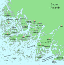
オーランド諸島東側のフィンランド多島海域の地図
この地域はフィンランド本土と比較して高い生活水準にある。漁業と水産加工業が主な産業である。この海域は、バルトニシンとニジマスの産地としてよく知られている。農業は、島々が小さいことと岩がちなことから限定的に行われている。しかしながら、気候に関してはフィンランド本土と比較して農業に向いていることから、リュマッチュラ島︵フィンランド語: Rymättylä、リミト島︵スウェーデン語: Rimito︶︶を含むいくつかの島々は、夏に最初の新ジャガイモを生産することでフィンランド本土側で有名である。この島々の経済の中で観光業の重要性は年々増してきている。
島々は橋かフェリーで結ばれており、オーランド諸島には小さな空港もある。フェリーは2つのカテゴリーに分けられる。1つは﹁ロードフェリー﹂︵フィンランド語: lautta, lossi、スウェーデン語: landsvägsfärja, färja︶であり、無料で利用可能で、ほとんどの場合近接した︵大きい︶島の間を短い航路でつないでいる。これらはいかだ様に作られており、通常は道路管理者によって運行されている。この中も小さいものの中にケーブル・フェリー︵フィンランド語: lossi、スウェーデン語: kabelfärja︶がある。そして、大きな規模になるとケーブルは使用しないフェリーとなる[注釈 3]。もう一方のフェリー︵フィンランド語: yhteysalus、スウェーデン語: förbindelsefartyg︶は、ロードフェリーと比較して、より船に近い形をしており、海事管理者によって運行され有料である。これらの船は小さく距離の離れた島々を結ぶ、より長い航路で運航されている。また、更に大きな営利目的のクルーズフェリーがフィンランド本土の都市、トゥルクとヘルシンキからオーランド諸島、そしてスウェーデン本土までを結んでいる。
寒い冬の間、いくつかの島々の間では公式にアイスロードが設置される。また、公式にアイスロードが設定されていな島へも氷上で車を運転して向かうことも一般的である。アイスロードはフィンランド本土から島々へ乗用車で移動することが出来るため、輸送が大幅に容易になる。年によるが、非常に氷が厚くなった場合、重いバンであっても通行することが可能である。一方で、春と秋の間に解氷期︵フィンランド語: kelirikko、スウェーデン語: menföre︶があり、この間の氷は徒歩移動も難しい程弱いにも関わらず、小さな舟での航行には厚すぎる状態となる。これにより、大型船が接岸できる桟橋を持たない島々が数日から数週間に渡って孤立することがある。この場合、ハイドロコプター、ホバークラフト、そしてヘリコプターでしか島にアクセスすることが出来なくなってしまう。
多くの重要な航路が、フィンランド多島海域の中に設定されている。航海は迷路の様に並ぶ島々や変化し続ける水深、数多の岩礁のため危険なものとなっている。このため、島々には様々な大きさの灯台や航海標識が点在している。水先案内人のサービスが行政によって維持されている。

メイポール︵ナグ︶
この群島の文化は、フィンランド沿岸部のスウェーデン語話者の物と類似している。サウナの様な典型的なフィンランドの文化の特徴の多くが、この島々の文化に根付いている。しかしながら微妙な違いもいくつか存在する。メイポールは、この島々の夏至祭で欠くことの出来ないものであるが、フィンランド本土側では不可欠なものでは無い。一方で、フィンランド本土側の夏至祭で伝統的な焚き火は、比較的最近になって島々へと持ち込まれた。
この群島で話される言語を基に、この群島は3つの部分に分割することが出来る。海域西側のオーランド諸島は、ほぼ完全にスウェーデン語圏に属する。トゥルンマー郡︵フィンランド語: Turunmaa、スウェーデン語: Åboland︶に属する南部の島々の人々は、多くが母語をスウェーデン語とする人々であるが、この地域はスウェーデン語とフィンランド語のバイリンガル地域である。そして北部の島々はフィンランド語の単一使用地域である。
フィンランド本土よりも前にキリスト教が島々に広まったため、大きな島に建てられた教会は比較的古いものが多い。13世紀から15世紀にかけてのものがあり、最も古いものはオーランド諸島に存在する。80%以上のフィンランド人がフィンランド福音ルター派教会の信者であり、この傾向は諸島内では幾分強く、正教会やカトリック教会の教区は存在しない。
この地域の料理文化は本土側のフィンランド料理に類似している。当然、バルトニシン、タイセイヨウサケ、そしてニジマスを主とする魚類は非常に重要である。またこの島々は、バターミルク、シロップ、麦芽を材料に使った伝統的な黒パンで著名である。クリスマスディナーのメインディッシュは通常ノーザンパイクであり、ハムが食べられるフィンランド本土とは対照的である。毎年のクリスマスでは、コルポの漁師がフィンランド大統領にパイクを届けている。

島々で生育するセイヨウネズ︵ビャクシン属︶。荒れた環境のため、高 さ15 cm (6 in)迄しか成長していない
この海域では独特で多様な生態系が形成されている。大きな島々の自然はフィンランド本土側の沿岸地域に類似しているものの、岩礁などの非常に小さな島々は根本的に異なる環境となっている。小さな島々では樹木はほとんど生えていないものの、入り江では豊かな植生がある。この環境は、日当たりが良く、比較的長い生育期を持ち、グアノで肥やされている。一方で、ほぼ常に吹いている風と、非常に薄い土壌、場合によっては土壌が全く無いため植物の生育は限定的である。バルト海の非常に低い塩分濃度のため、海水の飛沫は植物の生育には通常の海水と比較して害は少ない。殆どの島々が岩がちであるが、その内のいくつかはサルパウッセルカ分水嶺の延長に存在し、これらはモレーンの末端から構成されている。この中には、オロ島やユルモ島が含まれる。これらの島々における植物相及び動物相は、それら岩がちな近隣の島と比較して多様である。
この環境は1つの小さな島の中でさえ大きく変化する。これはこれらの島を形作る岩の特徴によるものである[15]。針葉樹林、ヒース[6]、小さな淡水沼、淡水池、汽水池、灌木林、草地、風化した岩々、風の吹きつける海岸、外洋から守られた小湾が直径数十メートルの小島に存在する。この環境のため多くの植物が表現型が変化している。例えば、小島に生えるビャクシン属は、高さ0.5メートル (1.6フィート)以下迄しか成長しないが、数平方メートルを覆う様に成長している。絶滅危惧種の植物にはイチョウシダ、テガタチドリが挙げられる[16]。
島々の陸地と沿岸の生態系とは対照的に、海の生態系においては生物多様性は幾分低いものとなっている。この理由として海水の塩分濃度が低いことが挙げられる。群島内の塩分濃度は僅か0.6%である[注釈 4]。現在の塩分濃度は過去の塩分濃度とは大きく変化しており、各生物種はこの環境変化に適応することが困難だったためである。しかしながら、特有の生物種が多いことは好ましい環境であることを示している。生息数の多い魚類は、バルトニシン、パイク、ホワイトフィッシュ、パーチ、カレイやヒラメである[17]。
この地域では、フィンランドの他の地域では見ることの出来ない多くの生物が生息している。ネズミイルカがそのような生物種の一例である。本種はバルト海北部で常に見ることの出来るクジラ目唯一の生物である。バルト海での現在の生息数は約600個体であると推計されており、推定1万から2万頭ほど生息していたとされる1世紀前と比較して、大きく生息数を減らしている[18]。他の例として、オジロワシが挙げられ、諸島内で重要な繁殖個体群である。諸島内において、珍しいもしくは絶滅寸前の鳥類や哺乳類としては、オニアジサシ、スズガモ、ハイイロアザラシ、ワモンアザラシ、ニシセグロカモメが挙げられる[17][16]。
この地域の島々は海鳥の停泊所でもある。この海鳥には、コケワタガモ、コオリガモ[19]、コブハクチョウ、ハジロウミバト、カンムリカイツブリ、そして様々な種類のカモメがある。近年カワウが群島内に進出しており、生息数を増やしている。しかしながらこのことは、カワウが密に生息し、彼らの排泄する糞が周囲の植物の生命を最終的に害するため自然愛好家には必ずしも好ましいものとは見做されていない。
この地域の環境に対する最も大きな脅威は、主に農業と養殖業が原因の富栄養化である[20]。このことは、バルト海では特に脅威となっている。これは、バルト海が非常に浅く、人類の活動の影響を薄め、拡散させる力が低いためである。富栄養化は、部分的にはフィンランドの制御下に置かれているが、バルト海の全体的な状況が悪化しているため、その影響全体は覆い隠されてしまっている。
この群島の多くの地域は、それらに近づくことが非常に難しいことから人間の活動から守られている。この海域の南部は、サーリストメリ国立公園︵フィンランド語: Saaristomeren kansallispuisto、スウェーデン語: Skärgårdshavets nationalpark︶に含まれており、数多の小さな自然保護地域が設定されている。そこには、春から夏の間に上陸することが禁止されている。
フィンランドの多島海域はユネスコの生物圏保護区に指定され[6]、うち﹁ビイェルケルとローグヒャル諸島﹂[19]および﹁シグニルヒャル・マルケット諸島﹂[16]はラムサール条約登録地である。
人口統計[編集]

経済と通信[編集]


群島周回道路[編集]
南西スオミ県に属する東側の島々においては、ほとんどの有人島が群島周回道路で接続されている。この道は、約160 to 190キロメートル (99–118マイル)の陸路と、30 to 50キロメートル (19–31マイル)の海上路で構成されている。通常、トゥルクの街がこの周回道路の起点であると考えられている。この道路は、下記の順番で町、村、島や諸島を辿る。 ●1. トゥルク︵フィンランド語: Turku︶/オーボ︵スウェーデン語: Åbo︶ ●2. ライシオ︵フィンランド語: Raisio︶/レソ︵スウェーデン語: Reso︶ ●3. ナーンタリ︵フィンランド語: Naantali︶/ノーデンダル︵スウェーデン語: Nådendal︶ ●4. メリマスク︵フィンランド語: Merimasku︶ ●5. アスカイネン︵フィンランド語: Askainen︶/ヴィルネス︵スウェーデン語: Villnäs︶ ●6. ミエトイネン︵フィンランド語: Mietoinen︶ ●7. タイヴァッサロ︵フィンランド語: Taivassalo︶ ●8. クスタヴィ︵フィンランド語: Kustavi︶ ●9. イニオ︵フィンランド語: Iniö︶/イニオ︵スウェーデン語: Iniö︶ ●10. ホウツカリ︵フィンランド語: Houtskari︶/フーチェール︵スウェーデン語: Houtskär︶ ●11. コルッポー︵フィンランド語: Korppoo︶/コルポ︵スウェーデン語: Korpo︶ ●12. ナウヴォ︵フィンランド語: Nauvo︶/ナグ︵スウェーデン語: Nagu︶ ●13. パライネン︵フィンランド語: Parainen︶/パルガス︵スウェーデン語: Pargas︶ ●14. カーリナ︵フィンランド語: Kaarina︶/サント・カリンス︵スウェーデン語: S:t Karins︶ ●15. トゥルク︵フィンランド語: Turku︶/オーボ︵スウェーデン語: Åbo︶ この周回道路には更に距離の短いものが存在しており、そちらは﹁小周回道路﹂と呼ばれる。こちらの周回道路では、ナーンタリのリュマッチュラ島からナウヴォの間をフェリーに乗り、上記の4から11までをスキップする。この﹁小周回道路﹂の長さは、約125kmである[14]。 この周回道路は通常自動車や自転車での旅行に使われる。この周回道路中のフェリーのほとんどが無料であるが、ホウツカリとイニオの間のフェリーは少額の乗船料が必要である。この周回道路は自動車であれば1日で回りきれるが、多くの旅行者が少なくともこの周回道路の周辺で1泊する。約20,000人の観光客が毎年この周回道路を訪れる。最も観光客が多いのは6月から8月の間である。主要な観光名所は周回道路中の風景と自然であるが、ロウヒサーリ荘園やいくつかの中世の教会も重要な観光地である。文化[編集]

自然と保全[編集]

歴史[編集]

詳細は「フィンランドの歴史」を参照
先史時代[編集]
島々は約1万年前に海中から隆起し始めた。この時期、デンマークの海峡は閉じており、現在のバルト海は淡水のアンキュルス湖であった。その後、現在の海峡が北海と繋がったことから、島々を囲む水が淡水から汽水へと変化したのは約7,600年前の事であるとされる[21]。最も古い考古学的発見は、ドラグスフェルドの凡そ紀元前4000年頃、櫛目文土器文化に関連するものである。この時期、外群島ではフーチェール︵ホウツカリ︶、コルポ︵コルッポー︶、ナグ︵ナウヴォ︶の主島の最高峰が形作られた。後氷期地殻均衡復元のため、全ての島々は当初から約25メートル (82フィート)隆起しており、元々存在した島々は面積が拡大し、新たな島々も形成された。
スウェーデン統治時代[編集]
12世紀から13世紀の間、この海域をスウェーデンが支配した。これと同じ時期、この海域の島々と沿岸部からフィンランドにキリスト教が広まった。この島々は、ストックホルムやトゥルク、そしてボスニア湾への侵攻に対する防衛に関して戦略上重要な位置にあった。このため、中世の間にスウェーデン・バルト帝国がこの島々を要塞化した。16世紀と17世紀の間、王室の郵便の輸送路は北の島々を経由するルートが設定されていた。 1808年、スウェーデン・バルト帝国とロシア帝国との間で第二次ロシア・スウェーデン戦争が勃発した。4月、ロシア帝国軍がオーランド諸島を含むこの海域の島々を占領した。船が没収されたため、地元住民の反乱が間もなく起こった。スウェーデンからの軍の助けで5月には島々はロシアの支配から解放された。スウェーデン軍はフィンランド本土側へ進出する拠点としてこの島々を使用した。この戦争が終わるまで、この海域の島々はスウェーデンの支配下にあった。しかし1809年のフレデリクスハムンの和約に続き、この海域の島々を他のフィンランドの地域と共に割譲させられた。そのためフィンランド多島海域は、ロシア帝国の影響下にあるフィンランド大公国領となった。フィンランド大公国統治時代[編集]
この節の加筆が望まれています。 |
クリミア戦争の間、英仏軍は、ボマルスンド城を攻撃し壊滅させた。1856年のパリ条約の結果、オーランド諸島は非武装地帯とされた。1916年にロシア軍がこの地域に再来し、この後5年間はロシア軍、後にフィンランド軍がオーランド諸島に駐留することとなった。
独立フィンランドの時代[編集]
1917年にフィンランドはロシア帝国から独立した。それから少しの後、この海域の西部に位置するオーランド諸島のスウェーデン語話者の住民たちが、オーランド諸島をスウェーデンに併合する様に主張した。この要望はスウェーデン側でも採り上げられ、様々な反応があったが結果としてオーランド危機が起こった。国際連盟はこの状況を解決するため、オーランド諸島住民の大多数の反対があったにも関わらず、1921年にこの海域の島々全てをフィンランド領とする裁定を行った。しかしながら、オーランドには広い自治権が与えられ、非武装地帯であることも再確認された。 1939年に勃発した冬戦争でソビエト連邦がフィンランドに侵攻した。この戦争の終わり、1940年、フィンランドはこの海域の東側に位置しているハンコを軍事基地として租借させるよう、ソビエト連邦から強要された。1941年になると継続戦争が勃発した。フィンランドは、ソビエト連邦からの侵攻に対して防衛を行うためオーランド諸島に軍を派遣したが、結果的に侵攻されることは無かった。またフィンランド軍はハンコを包囲攻撃し、この年の暮れにソビエト連邦軍は撤退した。フィンランド軍は1944年の終わりまでオーランド諸島に駐留した。 1995年、フィンランドは欧州連合に加入した。加入に関する国民投票については、オーランド諸島は個別に実施され、本土側とは別の結果になる可能性があった。もしオーランド諸島の住民が欧州連合への加入を否決すれば、デンマークの自治領でありながら欧州連合に加入していないグリーンランドと同じような状況となる可能性があった。しかしながら、双方の国民投票で欧州連合加入は可決された。ギャラリー[編集]
-

-

-
-
 ナグに属する内群島
 -
 ユルモ島の村
 -
 グルクロナに属する外群島の岩がちな島
 -
 イソカリ海事パイロット・ステーション。ウーシカウプンキの入り江へ船を案内する任に就いている。
 -
-
 フィンランド本土とオーランド諸島、スウェーデンを結ぶクルーズフェリーの中の1隻
 -
 主な島々を結ぶフェリーとして運行されているM/S アウラ
 -
 オーランド諸島に属する小島
 -
-
 国立公園内では、羊と牛が放し飼いにされている


関連項目[編集]
注釈[編集]
脚注[編集]
(一)^ abc“The website of Finland's environmental administration”. Ymparisto.fi (2005年7月18日). 2013年5月13日時点のオリジナルよりアーカイブ。2013年2月25日閲覧。
(二)^ “Vihreäpolku.info :: What kind of area is Archipelago sea”. Vihreapolku.info. 2009年10月10日閲覧。
(三)^ Saarten ja vetten maa Archived 5 December 2013 at the Wayback Machine.
(四)^ Geography of Indonesia (Asianinfo.org)
(五)^ “The website of Finland's environmental administration”. Ymparisto.fi (2005年7月18日). 2013年5月13日時点のオリジナルよりアーカイブ。2013年2月25日閲覧。
(六)^ abc“Archipelago Sea Area Biosphere Reserve, Finland” (英語). UNESCO (2018年12月). 2023年3月4日閲覧。
(七)^ “Lumparn in the Earth Impact Database”. Unb.ca. 2013年2月25日閲覧。
(八)^ “A study about the geology of the archipelago conducted by the Geological Survey of Finland” (PDF). 2013年2月25日閲覧。
(九)^ PBS Composer, www.pbs-composer.com. “The official pages of Åland”. Aland.ax. 2013年2月25日閲覧。
(十)^ “The Archipelao Sea Naval Command in Finnish” (フィンランド語). Mil.fi. 2008年10月22日時点のオリジナルよりアーカイブ。2013年2月25日閲覧。
(11)^ History of the archipelago at the website of the Archipelago Sea National Park in Finnish Archived 19 February 2009 at the Wayback Machine.
(12)^ The summer residence of the president of Finland Archived 28 September 2007 at the Wayback Machine.
(13)^ Lummaa, Virpi; Haukioja, Erkki; Lemmetyinen, Risto; Pikkola, Mirja (1998), “Natural selection on human twinning”, Nature 394 (6693): 533–534, Bibcode: 1998Natur.394..533L, doi:10.1038/28977, PMID 9707112
(14)^ “Map of the Small Ring Road”. Mapmytracks.com. 2013年2月25日閲覧。
(15)^ Special characteristics of the archipelago nature at the website of the Archipelago Sea National Park (in Finnish) Archived 18 February 2009 at the Wayback Machine.
(16)^ abc“Signilskär-Märket Archipelago | Ramsar Sites Information Service”. rsis.ramsar.org (2005年1月1日). 2023年3月4日閲覧。
(17)^ ab“The Archipelago Sea page at the website of the Natura 2000 programme”. Natura.org. 2013年2月25日閲覧。
(18)^ FIN. “Information about Harbour Porpoises in the Finnish-language website of the World Wide Fund for Nature”. Wwf.fi. 2011年5月4日時点のオリジナルよりアーカイブ。2013年2月25日閲覧。
(19)^ ab“Björkör and Lågskär Archipelago | Ramsar Sites Information Service”. rsis.ramsar.org (2005年1月1日). 2023年3月4日閲覧。
(20)^ Article about eutrophication in the website of Finland's environmental administration Archived 20 May 2011 at the Wayback Machine.
(21)^ 01.11.2011 08:30 Leena Laurila. “Geological history of the archipelago at the website of the Department of Geology at the University of Turku in Finnish”. Sci.utu.fi. 2013年2月25日閲覧。
外部リンク[編集]
![]() ウィキボヤージュには、フィンランド多島海域に関する旅行情報があります。
ウィキボヤージュには、フィンランド多島海域に関する旅行情報があります。
- Archipelago National Park
- Turku Archipelago
- Steamship s/s Ukkopekka cruise Naantali-Turku
- Interactive map of the ferries in Finland
- All guest harbors in the Archipelago of Turku and Aland
- Archipelago Research at University of Turku (In English)
- The official webpage of Åland (in English)
| 全般 |
|
|---|---|
| 国立図書館 |
|