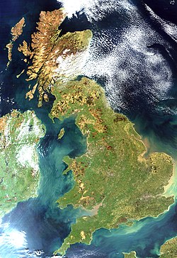
グレートブリテン島
| グレートブリテン島 | |
|---|---|
 ブリテン諸島 | |
| 所在地 |
|
| 所在海域 | 大西洋 |
| 所属諸島 | ブリテン諸島 |
| 座標 | 北緯53度0分0秒 西経2度0分0秒 / 北緯53.00000度 西経2.00000度座標: 北緯53度0分0秒 西経2度0分0秒 / 北緯53.00000度 西経2.00000度 |
| 面積 | 209,331 km² |
| 最高標高 | 1,344 m |
| 最高峰 | ベン・ネビス山 |
| 最大都市 | ロンドン |
グレートブリテン島︵グレートブリテンとう、英: Great Britain/羅: Britannia Maior[注釈 1]︶は、北大西洋に位置する島で、アイルランド島、マン島などとともにブリテン諸島を構成する。﹁グレートブリテン﹂という呼称は﹁リトルブリテン﹂との区別に基づいている[1]。ヨーロッパ大陸からみるとドーバー海峡を挟んで北西の方向にあたり、ヨーロッパ地域の一部である。面積は 209,331 km2で、世界で9番目に大きい島である︵島の一覧参照︶。グレートブリテン島は日本の本州より少し小さい。イギリスの国土の中心的な島で、同国の首都ロンドンをはじめとする多くの大都市を有する。大ブリテン島とも呼ばれる。
グレートブリテン島は、政治的に見ると、﹁グレートブリテンおよび北アイルランド連合王国﹂の構成要素であるイングランド、スコットランド、ウェールズの3つの﹁国︵カントリー︶﹂からなる。

イギリスとアイルランド

グレートブリテン島の位置


名前[編集]
﹁グレートブリテン﹂︵Great Britain︶という言葉は地名であり、ブリテン諸島︵イングランド、スコットランド、ウェールズ︶を指す[1]。これは﹁リトルブリテン﹂︵Little Britain ブルターニュ︶との区別で使われている[1][注釈 2]。由来[編集]
グレートブリテン島をさす最古の名前は、紀元前6世紀頃のカルタゴ人航海者の記録にある﹁アルビオン﹂である。その後、紀元前4世紀のギリシャ人商人の航海記にある﹁プレタニケ﹂から、現在のブリテン諸島を指す言葉として﹁ブリトニ﹂という呼び名が生まれ、次第に定着して、その最大の島であるこの島がラテン語で﹁ブリタンニア﹂と呼ばれるようになった。 ブリトン人[注釈 3]は前1世紀頃からローマ共和国、ローマ帝国、アングロ・サクソン人の相次ぐ侵攻を受けて、その一部がフランスに逃れる。フランスではブリトン人の住むようになった地域を﹁ブルターニュ﹂[注釈 4]と呼び、本来のブリタニアを﹁グランド・ブルターニュ﹂[注釈 5]と呼んで区別した。﹁古ブリテン島﹂[注釈 6]の意味である。これが英語に輸入され、英訳された形の﹁グレートブリテン﹂という地名が定着する。分類[編集]
●北部: スコットランド ●南部: イングランド ●西部: ウェールズ主要都市[編集]
●グラスゴー ●エディンバラ ●マンチェスター ●バーミンガム ●ロンドン ●カーディフ地形[編集]
古期造山帯に位置しているため、平坦な土地である。アイルランド島との間をアイリッシュ海、スカンディナビア半島およびユトランド半島との間を北海とよぶ。地質[編集]

詳細は「グレートブリテン島の地質」を参照
グレートブリテン島では太古代以降のほぼ全ての地質時代の岩石が産出する。地震学的研究によれば、グレートブリテン島を一帯とする地域では、地球の地殻は27 - 35 kmの厚みがある。最古の岩石はスコットランド北西部で発見されたルイス片麻岩で、推定で少なくとも27億年前の年代のものであり、これは地球の歴史の半分よりも古い。これらの岩石は、グレートブリテン島およびアイルランド島の地殻の大部分を占めるものと考えられているが、さらにブルターニュ半島やチャンネル諸島の地表まで広がっていると推定される。一方で、最も若い岩石はイングランド南東部で発見されている。
脚注[編集]
注釈[編集]
- ^ ブリタンニア・マーイヨル
- ^ 原文:
‘Great Britain’ is the geographical name of that island of the British Isles which comprises England, Scotland and Wales (so called to distinguish it from ‘Little Britain’ or Brittany).[1]
- ^ 英: Britons
- ^ 仏: Bretagne、ブリタニアのフランス語形
- ^ 仏: Grande-Bretagne、大ブリタニア
- ^ 仏: l'ancienne Bretagne insulaire
出典[編集]
- ^ a b c d Hunter 1995, p. 1305.
参照文献[編集]
- Hunter, Brian (1995). “United Kingdom of Great Britain and Northern Ireland”. The Statesman’s Year-Book. Palgrave Macmillan. pp. 1305-1385. ISBN 978-1-349-39297-1

