
リカンカブール山
| リカンカブール山 | |
|---|---|
 リカンカブール山の山頂 | |
| 標高 | 5,916[1] m |
| 所在地 |
アントファガスタ州エルロア県 ポトシ県 |
| 位置 | 南緯22度50分00秒 西経67度53分00秒 / 南緯22.83333度 西経67.88333度座標: 南緯22度50分00秒 西経67度53分00秒 / 南緯22.83333度 西経67.88333度[1] |
| 山系 | アンデス山脈 |
| 種類 | 成層火山 |
| 最新噴火 | 不明 |
 リカンカブール山  リカンカブール山 | |

リカンカブール山︵リカンカブールさん、スペイン語: Volcán Licancabur︶は、チリとボリビアとの国境の最南端にある非常に対称性の高い成層火山である。山はボリビアのベルデ湖のちょうど南西にある。火山はアタカマ塩原地域の景色を見下ろす。火山の北東斜面の下部3分の2、4,360 mの裾から5,400 mまでの広大な地域はボリビアに属し、残りの上部3分の1を含む火口と山頂はチリに属する[2][3]。
山頂と火口は全てチリにあり、国境から南西へ1 km強のわずかな距離にある。火口は400 mの幅があり70 x 90 mの火口湖、リカンカブール湖あって年間のほとんどを氷が覆っている。 世界で最も高い海抜高度にある湖の一つで、-30 ℃の気温になるのにもかかわらず動物プランクトンが生息する。
リカンカブール山の最近の火山活動は、北西と南西の裾野に6 kmも下り伸びる大規模な溶岩流を引き起こし、より古い溶岩流は15kmに到達し火砕流は山頂から12 kmの所まで堆積した。大規模なインカ帝国の遺址が山頂にあり、コロンブス以前の登頂の証拠としてだけでなく500から1000年以上の間大きな噴火活動が無かったことを裏付ける。
名前の由来
[編集]
リカンカブールという言葉は、火山を言い表すためにアタカメーニョ族︵リカンアンタイ族、Likan-antay︶が使っていたクンサ語の名前をカスティーリャ語化したものである。“lican - 人々”、“cabur - 山”を表し、“人々の山”を意味する。
ギャラリー
[編集]-
![前景はペニテンテの塊でできた氷の森[4]。](//upload.wikimedia.org/wikipedia/commons/thumb/e/e3/Iconic%2C_Conical_Licancabur_Watches_Over_Chajnantor.jpg/120px-Iconic%2C_Conical_Licancabur_Watches_Over_Chajnantor.jpg)
-
 サンペドロ・デ・アタカマから見たリカンカブール山の眺め。
 -
 ベルデ湖から見たリカンカブール山の眺め。
 -
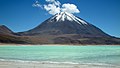 リカンカブール山とベルデ湖。
 -
 山頂から見た火口湖、リカンカブール湖。
 -
 火口湖の岸。


参考文献
[編集]- Biggar, John (2005). The Andes: A Guide for Climbers (3rd ed.). Andes Publishing (Scotland). p. 304 pp. ISBN 0-9536087-2-7
- González-Ferrán, Oscar (1995). Volcanes de Chile. Santiago, Chile: Instituto Geográfico Militar. p. 640 pp. ISBN 956-202-054-1 (in Spanish; also includes volcanoes of Argentina, Bolivia, and Peru)
- De Silva, Shanaka L.; Francis, Peter (1991). Volcanoes of the Central Andes. Springer-Verlag. p. 216 pp. ISBN 3-540-53706-6
- NASA Licancabur Expedition: Exploring the Highest Lakes on Earth
- ^ a b "リカンカブール山". Global Volcanism Program. Smithsonian Institution. 2012年11月1日閲覧。
- ^ Licancabur in Acme Mapper
- ^ Lago Licancabur in Google Maps
- ^ “Iconic, Conical Licancabur Watches Over Chajnantor”. ESO Picture of the Week 2012年10月3日閲覧。
関連項目
[編集]外部リンク
[編集]- Excursion al Volcán Licancabur
- Licancabur, tour 2003
- Highest Lakes on Earth
- Licancabur, cerca de Marte - Mercuria Calama article
この項目は、チリに関連した書きかけの項目です。この項目を加筆・訂正などしてくださる協力者を求めています(ウィキプロジェクト 国)。 |
この項目は、ボリビアに関連した書きかけの項目です。この項目を加筆・訂正などしてくださる協力者を求めています(ウィキプロジェクト 国)。 |
この項目は、山岳に関連した書きかけの項目です。この項目を加筆・訂正などしてくださる協力者を求めています(PJ山)。 |
| 国立図書館 |
|
|---|---|
| 地理 |
|