
LIDAR

LIDAR︵ライダー︶︵英語‥Light Detection and Ranging、Laser Imaging Detection and Ranging︶Lidar あるいは LiDAR とも表記される。﹁光検出と測距﹂ないし﹁レーザー画像検出と測距﹂︶は、光を用いたリモートセンシング技術の一つで、パルス状に発光するレーザー照射に対する散乱光を測定し、遠距離にある対象までの距離やその対象の性質を分析するものである。日本語ではライダー、ライダとカタカナ書きされることも多い。軍事領域ではしばしばアクロニム LADAR (Laser Detection and Ranging) が用いられる。
この技法はレーダー︵Radar、Radio Detecting and Ranging、電波探知測距︶に類似しており、レーダーの電波を光に置き換えたものである。対象までの距離は、発光後反射光を受光するまでの時間の差で求まる。そのため、レーザーレーダー (Laser radar) の語が用いられることもある。
ライダーは地質学、地震学、リモートセンシング、 大気物理学で用いられる。近年は自動運転車用センサーとしても注目されている[1][2]。
民間利用としてはAppleのiPhone 12 Pro以降やiPad Pro第2世代以降に搭載されており、﹁ナイトモード時の対象物測距﹂や﹁3Dスキャン﹂機能等もこの技術を用いて実現されている。

スターファイア光学実験場(en)において調整中の色素レーザー(en)。 LIDAR と レーザーガイド星(en) の実験のために用いられる。レーザーの波長は、大気上層のナトリウム原子を励起させるのに最適な、ナトリウムのフラウンホーファー線の波長に設定されている。
基本的なLIDAR システムの作動。変調されたレーザー光が回転す る鏡(上)で反射され、レーザー光が左右に首を振る事で走査され反射して戻ってきたレーザー光が検出器で捕らえられ一次元若しくは二次元的な寸法を得る。(中)、位相角のずれから対象物までの距離を得る。(下)
ライダーを用いるとこれらの問題は解決する。ライダーの光束は密度が高く、コヒーレンスも高い。それだけでなく、波長が極めて短い︵紫外光ではおよそ 10 μm から約 250 nm の範囲︶。このような電磁波は小さな物体によっても極めてよく﹁反射﹂︵後方散乱と呼ばれる︶される。ライダーの使用法によっては、別の種類の散乱が利用される。レイリー散乱、ミー散乱、ラマン散乱、蛍光である。ライダーの波長は煙などの大気によって運ばれる粒子︵エアロゾル︶、雲、大気の分子の測定に最適である。
レーザーの光束は通常極めて絞り込まれ、細いビームとなっているので、極めて高い光学的解像度を以て大気の特徴をマップすることができる。更に、多くの化学物質において、可視光はマイクロ波に比べ強く相互作用するので、それらを検出する感度が高い。各種波長のレーザーを上手に組み合わせれば、散乱光の強度と波長との関係から、大気の組成を離れた所から調べることができる。
ライダーは大気の研究と気象学に主に用いられてきたが、近年では航空機や人工衛星に﹁ルックダウン﹂ downward-looking 型のライダーを搭載して行う調査やマッピングの方法が開発されるようになった。
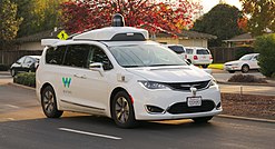
米Waymoの自動運転実証車。ナンバープレート上部、前輪上部、車 両天井の黒いドームの中にそれぞれLIDARが搭載されている。

自動運転バス側面に取り付けられた円筒形のLiDAR︵栃木県日光市 での実証実験車、2023年︶
自動運転技術 - 条件付き自動運転であるレベル3や、ドライバーによる運転を前提としないレベル4~5の対応になると、高速道路や一般道路を安全に自律走行する機能が必要となる。そのため、センシングの冗長性を担保する理由で、カメラやミリ波レーダーに加えて、ライダーが採用される。これはライダーは色の識別や悪天候時のセンシングを苦手とする代わりに、距離の計測においては他のセンサーの認識精度を凌駕するためである。このような事情から、矢野経済研究所の発表によると2030年にはライダーの市場規模は4,959億円になると見込まれている。世界初の自動運転レベル3を達成したホンダ・レジェンドや、トヨタ・ミライやレクサス・LSに採用されるAdvanced Driveなどでライダーが搭載されている。
地質学や地震学では、航空機搭載型ライダーとGPSを組み合わせ、断層や隆起・沈降に伴う地殻の変位を測定するのに極めて役立っている。このシステムを用いれば、地殻変動を樹木越しに測ることすらできる。ワシントンのシアトル断層を発見したシステムとして有名になった。2004年の噴火によって発生したセント・ヘレンズ山の隆起の程度も、噴火前後のデータを比較することで示すことができた。
航空機/衛星搭載型ライダーシステムは氷河の観測にも役立っている。ライダーであればわずかな消長をも測定できるためであり、アメリカ航空宇宙局(NASA)のICESat(en)には、この目的でライダーが搭載されている。
林業においてもライダーはさまざまに応用される。航空機/衛星搭載型ライダーによって、林冠の高さ、バイオマスの測定、leaf area の測定が行える。他の産業、例えばエネルギー産業、鉄道、運輸関連分野でも、手早いサーベイ法として用いられる。
宇宙船によって月面に設置された鏡を用いて︵月レーザー測距実験参照︶、月と地球の距離を観測する世界規模のネットワークがあり、ここでもライダーが用いられる。月との距離がミリメートル単位の精度で測定できるので、一般相対性理論の検証に有用である。
宇宙機に搭載されたLIDARとしては、1994年のSTS-64にLITEが搭載され、雲やエアロゾルを観測した。火星を回るNASAの探査機マーズ・グローバル・サーベイヤー(1996年打上げ)は、MOLA (the Mars Orbiting Laser Altimeter) と名付けられたライダーを搭載しており、目をみはる程正確な地形図をもたらしている。また、2003年に打ち上げられたNASAのICESat衛星にもGLASというLIDARが搭載され、氷床や大気の観測を行った。2006年に打ち上げられたNASAのCALIPSO衛星はCALIOPを搭載し、大気の観測を行っている。2014年にESAが打ち上げる予定のADM-Aeolusも風や大気を観測するLIDARが搭載されている。日本初の月周回衛星かぐやも、一種のライダーであるレーザー高度計LALT (Laser ALTimeterthe︶を搭載しており、月全面の正確な地形高度データを取得した。

車載ライダーを用いて生成された点群データ。18秒以上の撮影時間中に およそ2300万点の点が生成された。
大気物理学では、中層および上層部の大気に含まれるいくつかの物質の濃度を遠距離から測るのに用いられる。カリウム、ナトリウム、分子状の窒素及び酸素といった物質である。これらの濃度を測定することで、温度を計算することもできる。ライダーは風速の測定や、エアロゾル粒子の鉛直方向での分布を調べるためにも用いられる。
海洋学では、植物プランクトンの蛍光及び海洋表層の総合的なバイオマスの推定に用いられる。船舶による測定が困難な海域での海底探査にも航空機に搭載して用いられる。
また、上記以外にも速度超過に対する交通取締︵いわゆるネズミ捕り︶用としてレーダーの代わりに用いられることがある。レーダー取締り機は携帯するには大型であり、特定の車両を分離して測定することがしばしば困難であるが、ライダーを用いると小型のカメラ式取締機によって、沢山走っている車両の内一台を狙い撃ちにすることができる。レーダー取締機はドップラー効果を用いて対象の速さを直接測定するが、ライダーの場合、二点間を通過する時間から速さを計算する。
軍事応用を詳述するには時期尚早であるが、イメージングに関するかなりの研究が進んでいることが知られている。空間分解能が高いため、対象︵戦車など︶の細かな特徴を捉えることができる。軍事分野では LADAR のアクロニムで呼ばれることが多い。
立体イメージングが可能である。スウェーデン、デンマーク、アメリカ合衆国、イギリスで軍事応用が研究されており、数キロメートル先の対象の立体像を 10 cm 以下の誤差で描出することができる。
イギリスにある欧州トーラス共同研究施設 (JET) では、ライダーを用いたトムソン散乱の測定を行い、プラズマ中の電子密度、温度プロフィールを求めている[3]。
隠しカメラを検出する﹁Laser-Assisted Photography Detection﹂(LAPD) という技術の開発も進んでいる[4]。
概説[編集]
ライダーとレーダーの最も基本的な相違は、ライダーはレーダーよりも遥かに短い波長の電磁波を用いることである。典型的には紫外線、可視光線、近赤外線である。一般的に、検出できる物体や物体の特徴のサイズは、波長を下回ることができない。したがって、ライダーはレーダーよりもエアロゾルや雲の粒子の検出に向いており、大気の研究や気象学にとって有用である。 ある物体が検出されるには、伝導性に不連続性があり進行してきた波を反射する必要がある。レーダー波︵マイクロ波またはラジオ帯域︶は金属物によって効率よく反射されるが、雨滴や岩といった非金属は反射を起こしにくく、物質によってはまったく反射が検出できず、レーダーでは見つからない場合がある。エアロゾルや分子のような極めて小さな対象は特に不得手である。

構成[編集]
ライダーの構成は大きく二種類に分けられる。一つはマイクロパルスライダー (micropulse lidar) システム、もう一つは高エネルギー (high energy) システムである。 マイクロパルスライダーは、レーザー技術の進歩とコンピュータの演算能力の驚異的な向上とが組み合わされて可能となったものである。比較的低出力︵1ワットのオーダー︶のレーザーを用い、しばしば、﹁目に優しい﹂(eye-safe)システムと呼ばれる。目を防護し失明を回避するための予防措置をとらずに用いうるからである。 高エネルギーシステムは大気の研究では一般的である。雲の高さや層構造、雲の粒子の性質︵消失係数 extinction coefficient、後方散乱係数 backscatter coefficient、偏光解消度 depolarization︶、温度、圧力、風、湿度、微少な気体の濃度︵オゾン、メタン、窒素酸化物など︶などの大気のパラメタを測定することができる。 次に、ライダーを構成する要素を挙げる。 (一)レーザー — 科学研究以外の分野では波長 600-800 nmのレーザーが最も一般に用いられる。安価で大出力のものが得られるが、﹁目に優しく﹂はない︵失明の可能性がある︶。﹁目に優しい﹂ことは軍事利用ではしばしば必要となる。波長1550 nm のレーザーは﹁目に優しい﹂が、十分な出力のものを得るのが難しく、一般的ではない。航空機搭載型ライダーは一般的に 1064 nm のものを用いる。海底探査システムの中には水中透過性の高い 532 nm のレーザーを用いる場合がある。波長の他にも、発光間隔︵データ収集速度を決めることになる︶と発光時間︵距離方向の分解能に関係する︶も適当に設定しなければならない。 (二)スキャナと光学系 — データ収集速度は、システムのデータ走査速度にも影響される。走査は二次元的に行われるが、その方法は様々である。二枚の平面鏡を振動させるもの、多角形の鏡を用いるもの、スキャナが二軸をもつものなどである。光学系の性能は、角度方向の分解と、検出できる距離の限界に影響する。反射光の分離には、穴の開いた鏡を用いる方法とビームスプリッターを用いる方法がある。 (三)受光器と電子機器 — 受光器にはさまざまな物質が用いられる。ケイ素とインジウムガリウム砒素を用いたピンフォトダイオードやアバランシェフォトダイオードが一般的であるが、波長によっては光電子増倍管も使われる。受光器の感度は、ライダーの他の部分の設計とうまくバランスを取らなければいけない。 (四)ポジショニングとナビゲーション — ライダーを可動型のプラットフォーム︵航空機や人工衛星︶に搭載する場合は、センサの絶対的な位置と方向を決定する装置が必要である。GPSと慣性誘導装置が用いられる。応用[編集]


関連項目[編集]
- en:Atomic line filter
- en:Time domain reflectometry
- en:Optical time domain reflectometer
- en:Satellite laser ranging
- TOFカメラ
- 測域センサ
- 三次元測定機
- ソナー
- 補償光学
- 光ヘテロダイン
- ドップラーシフト
- 航空レーザー測量
- ドップラー・ライダー
- SLAM
- 齊藤保典
- 国際レーザー測距事業
脚注[編集]
(一)^ “Autonomous Vehicle Lidar: A Tutorial (English Edition) [プリント・レプリカ Kindle版]”. Amazon Services International, Inc. 2020年7月10日閲覧。
(二)^ 吉郎, 鶴原. “日経ビジネス電子版”. 日経ビジネス電子版. 2019年7月29日閲覧。
(三)^ “Lidar Thomson Scattering Diagnostic”. Focus On Articles. EFDA-JET. 2007年7月2日時点のオリジナルよりアーカイブ。2016年9月22日閲覧。
(四)^ “盗撮を一網打尽。iPhoneのLiDARセンサーを使って隠しカメラを発見する手法が開発される”. Impress. (2021年11月24日)