
フィリピン海プレート


フィリピン海プレート︵フィリピンかいプレート、英: Philippine Sea Plate︶は、東は小笠原海溝やマリアナ海溝、北から西にかけては南海トラフ・琉球海溝・ルソン海溝・フィリピン海溝などに囲まれた海洋プレートである。
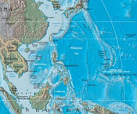
太平洋の北西部をしめるフィリピン海が主な領域。伊豆諸島・小笠原諸島・マリアナ諸島・ヤップ島・パラオと連なる島弧のほか、大東諸島、ルソン島の一部がこのプレート上にある。また、本州の中でも唯一伊豆半島だけがフィリピン海プレート上にある。
 東縁は伊豆・小笠原海溝やマリアナ海溝・ヤップ海溝などの沈み込み帯であり、北ほど相対速度が大きく、南東方向から年間5 - 1cmの速度で太平洋プレートが沈み込んでいる。この沈み込み運動により火山帯である伊豆・小笠原・マリアナ弧が形成され、現在も火山活動が継続している。背弧リフトとしてマリアナトラフやスミスリフトなどが形成されており、大陸地殻は薄い。ヤップ海溝の南側では発散型境界であるアユトラフが形成されている。このアユトラフは西パプア州北岸のマノクワリトラフでオーストラリアプレート下に沈み込み、フィリピン海プレートの南縁を成している。
北縁や西縁は南海トラフや琉球海溝、フィリピン変動帯であり、南ほど相対速度が大きく、南東方向から年間3 - 11cmで沈み込み帯が形成されている。
北縁付近から台湾付近にかけて、相模トラフ・伊豆半島・南海トラフ・琉球海溝を介してフィリピン海プレートが南東から陸側プレート︵北アメリカプレート及びユーラシアプレート︶下に沈み込んでいる。相模トラフの東端は太平洋プレートと重なり、世界的にも数少ないT-T-T型トリプルジャンクションとなっている[7]。伊豆弧の北端はフォッサマグナに激しく衝突付加し、御坂山地や丹沢山地を形成した。現在は、伊豆半島付近が変形前線となっている。南海トラフの島弧である西南日本弧では、新潟-神戸歪集中帯や右横ずれ断層の中央構造線断層帯が発達する。琉球海溝では背弧海盆運動として沖縄トラフが形成されている。
琉球海溝の西端である台湾付近からフィリピンを介してモルッカ海付近までは、島弧の東西両側に沈み込み帯が南北に伸び、その中軸に横ずれ断層帯が形成する幅広い変動帯︵en:Philippine Mobile Belt︶となっている。メイン︵より相対速度が大きい︶の収束境界は、台湾では花東縦谷断層、ルソン島より北側ではマニラ海溝、南側ではフィリピン海溝、及びモルッカ海衝突帯となっている。
この変動帯の北端である台湾では、台湾西部からユーラシアプレートが西から衝突・沈み込み、台湾山脈を形成している。一方、台湾東部では左横ずれ成分含む逆断層である花東縦谷断層が発達する。
台湾の南では、マニラ海溝を介してユーラシアプレートが西から沈み込み、ルソン島弧を形成している。このルソン島弧のバタネス付近では、マニラ海溝の斜め沈み込みに伴い、北東-南西走向の雁行山脈群が発達している。
マニラ島北東沖付近では、東ルソン海溝を介してフィリピン海プレートが東から沈み込み、マドレ山脈を形成している。ルソン島中部付近で、メインの沈み込み帯が南シナ海側のマニラ海溝からフィリピン海側のフィリピン海溝に偏移する。この偏移で、ルソン島側は西へ、ビサヤ諸島は東へ相対的に移動する運動が生じるため、ルバン断層、レガスピ断層などの左横ずれ断層が形成されている。また、フィリピン海溝が南南東に伸びるのに対し、相対運動は北西-南東方向で、斜めに沈み込んでいる。そのため、横ずれ成分を解消するためにフィリピン海溝の島弧である東フィリピン弧では、海溝に並行して左横ずれ断層であるフィリピン断層が発達し、ブロック運動をしている。
その一方で、マニラ海溝の南方延長上にも、ネグロス海溝・スールー海溝・コタバト海溝など介してユーラシアプレートが西から衝突・沈み込んでいる。
フィリピンの南では、タラウド諸島からモルッカ海中軸にかけて、モルッカ海衝突帯が南北に伸びている。このモルッカ衝突帯は、モルッカ海プレートが西のユーラシアプレートと、東のフィリピン海プレートの両側に沈み込み、海溝同士が衝突して形成された。そのため、地表には既にモルッカ海プレートは存在しておらず、スラブとして地下に存在している。
モルッカ海南部から東西走向の左横ずれ断層であるソロン断層が西パプア州へ伸び、マノクワリトラフに並行する形で合流する。インドネシア西部では、フィリピン海プレート・ユーラシアプレート・オーストラリアプレートの3つのプレートが衝突しあっており、複数のマイクロプレートが形成されている[8]。
東縁は伊豆・小笠原海溝やマリアナ海溝・ヤップ海溝などの沈み込み帯であり、北ほど相対速度が大きく、南東方向から年間5 - 1cmの速度で太平洋プレートが沈み込んでいる。この沈み込み運動により火山帯である伊豆・小笠原・マリアナ弧が形成され、現在も火山活動が継続している。背弧リフトとしてマリアナトラフやスミスリフトなどが形成されており、大陸地殻は薄い。ヤップ海溝の南側では発散型境界であるアユトラフが形成されている。このアユトラフは西パプア州北岸のマノクワリトラフでオーストラリアプレート下に沈み込み、フィリピン海プレートの南縁を成している。
北縁や西縁は南海トラフや琉球海溝、フィリピン変動帯であり、南ほど相対速度が大きく、南東方向から年間3 - 11cmで沈み込み帯が形成されている。
北縁付近から台湾付近にかけて、相模トラフ・伊豆半島・南海トラフ・琉球海溝を介してフィリピン海プレートが南東から陸側プレート︵北アメリカプレート及びユーラシアプレート︶下に沈み込んでいる。相模トラフの東端は太平洋プレートと重なり、世界的にも数少ないT-T-T型トリプルジャンクションとなっている[7]。伊豆弧の北端はフォッサマグナに激しく衝突付加し、御坂山地や丹沢山地を形成した。現在は、伊豆半島付近が変形前線となっている。南海トラフの島弧である西南日本弧では、新潟-神戸歪集中帯や右横ずれ断層の中央構造線断層帯が発達する。琉球海溝では背弧海盆運動として沖縄トラフが形成されている。
琉球海溝の西端である台湾付近からフィリピンを介してモルッカ海付近までは、島弧の東西両側に沈み込み帯が南北に伸び、その中軸に横ずれ断層帯が形成する幅広い変動帯︵en:Philippine Mobile Belt︶となっている。メイン︵より相対速度が大きい︶の収束境界は、台湾では花東縦谷断層、ルソン島より北側ではマニラ海溝、南側ではフィリピン海溝、及びモルッカ海衝突帯となっている。
この変動帯の北端である台湾では、台湾西部からユーラシアプレートが西から衝突・沈み込み、台湾山脈を形成している。一方、台湾東部では左横ずれ成分含む逆断層である花東縦谷断層が発達する。
台湾の南では、マニラ海溝を介してユーラシアプレートが西から沈み込み、ルソン島弧を形成している。このルソン島弧のバタネス付近では、マニラ海溝の斜め沈み込みに伴い、北東-南西走向の雁行山脈群が発達している。
マニラ島北東沖付近では、東ルソン海溝を介してフィリピン海プレートが東から沈み込み、マドレ山脈を形成している。ルソン島中部付近で、メインの沈み込み帯が南シナ海側のマニラ海溝からフィリピン海側のフィリピン海溝に偏移する。この偏移で、ルソン島側は西へ、ビサヤ諸島は東へ相対的に移動する運動が生じるため、ルバン断層、レガスピ断層などの左横ずれ断層が形成されている。また、フィリピン海溝が南南東に伸びるのに対し、相対運動は北西-南東方向で、斜めに沈み込んでいる。そのため、横ずれ成分を解消するためにフィリピン海溝の島弧である東フィリピン弧では、海溝に並行して左横ずれ断層であるフィリピン断層が発達し、ブロック運動をしている。
その一方で、マニラ海溝の南方延長上にも、ネグロス海溝・スールー海溝・コタバト海溝など介してユーラシアプレートが西から衝突・沈み込んでいる。
フィリピンの南では、タラウド諸島からモルッカ海中軸にかけて、モルッカ海衝突帯が南北に伸びている。このモルッカ衝突帯は、モルッカ海プレートが西のユーラシアプレートと、東のフィリピン海プレートの両側に沈み込み、海溝同士が衝突して形成された。そのため、地表には既にモルッカ海プレートは存在しておらず、スラブとして地下に存在している。
モルッカ海南部から東西走向の左横ずれ断層であるソロン断層が西パプア州へ伸び、マノクワリトラフに並行する形で合流する。インドネシア西部では、フィリピン海プレート・ユーラシアプレート・オーストラリアプレートの3つのプレートが衝突しあっており、複数のマイクロプレートが形成されている[8]。
概要[編集]
フィリピン海プレートがユーラシアプレートに沈み込むことで、海溝型地震である東海地震︵南関東~東海︶、東南海地震︵東海~南紀︶、南海地震︵南紀~四国︶が起きる。東海地震は静岡県の沖合、関東地震は神奈川県・千葉県の沖合が震源域となりうる巨大地震であり、防災上の重要性が高い。また、1923年の関東大震災をもたらした大正関東地震は、フィリピン海プレートが北アメリカプレートに沈み込む運動に伴う地震である。関東地方の地下には北アメリカ、フィリピン海、太平洋の3つのプレートが存在しており、このように2重にプレート間地震のリスクのある地域は世界的にも少ない。 伊豆半島と本州との衝突︵プレート同士の衝突︶は現在も続いている。丹沢山地は、フィリピン海プレート︵伊豆半島︶の北アメリカプレートへの衝突付加に伴う隆起によって形成された地形である。伊豆付近では地殻の浮揚性が高く、北西-南東走向の横ずれ断層が発達しているほか、この割れ目に沿って形成されたと考えられる火山群︵伊豆東部火山群︶がある。箱根火山、富士山などはこの伊豆孤の衝突の影響を受けている。また、このプレートの変形の影響を受けて、伊豆東方沖から小田原付近に西相模湾断裂と呼ばれるプレートの断裂帯があるとする学説もあるが、異論もある。 東京大学と防災科学技術研究所の研究グループは、2010年7月、フィリピン海プレートが、紀伊半島の西端から淡路島中部を通って鳥取市近辺へと至る地域の地下で、プレートが裂けている可能性が高いことを発表した。断裂の結果、近畿地方の下はプレートが深く沈み込み、支えのない状態になっている[1][2]。形成史[編集]
暁新世にフィリピン海プレートと太平洋プレートの収束型境界である伊豆・小笠原・マリアナ海溝が形成されたことによって誕生したプレート。現存する地表の大部分は誕生以後に形成されたマントルプルーム・背弧海盆運動による海洋性地殻で、島弧の他は白亜紀に形成された花東海盆と大東海嶺群がこの例外となっている。 約5000万年前にマントルプルーム運動によって西フィリピン海盆が形成を開始し、プレートが拡大し始めた。約4900万年前には太平洋プレートの沈み込みに伴う火成活動としてボニライトの形成を開始した。約4500万年前には太平洋スラブが地下深部に到達し、島弧として九州・パラオ海嶺︵Kyushu-Palau Ridge︶が形成、西フィリピン海盆が引き続き活動し拡大した。約3000万年前に新たに火山フロント付近でリフトが形成され始め、島弧が九州・パラオ海嶺と伊豆・小笠原・マリアナ島弧︵Izu-Bonin-Mariana (IBM) arc︶に分離、及び四国-パレスベラ海盆の形成が開始した。この背弧リフトの拡大は約1500万年前に停止した[注 1]。約2000万年前に太平洋プレートと接していたプレート北端の古琉球弧の海溝がユーラシア大陸に沈んでいた海溝と衝突[注 2]し、ユーラシアプレートとの境界に変わった︵南海トラフ・琉球海溝︶[注 3]。また、同時期にマニラ海溝の沈み込みが開始した。約600万年前から伊豆・小笠原・マリアナ島弧では再びリフトの活動が再開し、マリアナトラフが形成され、西マリアナ海嶺と東マリアナ海嶺が分裂した。約500万年前にパラワン島弧のマニラ海溝への衝突やモルッカ海衝突帯の形成、フィリピン海溝の沈み込みが開始した。また、マニラ海溝では台湾地塊が衝突し、急激な隆起が開始した[3]。プレート北端では1200万年前より伊豆・小笠原・マリアナ島弧の北アメリカプレートへの衝突が開始しており、約500万年前に丹沢地塊、約100万年前に伊豆地塊が衝突している[4]。約200万年前より沖縄トラフの拡大が開始した[5][6]。 これらの活動によってフィリピン海プレートは誕生時の5200万年前と比較すると、面積が拡大しつつ、90°時計回りに回転しながら北に移動した[3]。現在のプレート境界の地形[編集]
 東縁は伊豆・小笠原海溝やマリアナ海溝・ヤップ海溝などの沈み込み帯であり、北ほど相対速度が大きく、南東方向から年間5 - 1cmの速度で太平洋プレートが沈み込んでいる。この沈み込み運動により火山帯である伊豆・小笠原・マリアナ弧が形成され、現在も火山活動が継続している。背弧リフトとしてマリアナトラフやスミスリフトなどが形成されており、大陸地殻は薄い。ヤップ海溝の南側では発散型境界であるアユトラフが形成されている。このアユトラフは西パプア州北岸のマノクワリトラフでオーストラリアプレート下に沈み込み、フィリピン海プレートの南縁を成している。
北縁や西縁は南海トラフや琉球海溝、フィリピン変動帯であり、南ほど相対速度が大きく、南東方向から年間3 - 11cmで沈み込み帯が形成されている。
北縁付近から台湾付近にかけて、相模トラフ・伊豆半島・南海トラフ・琉球海溝を介してフィリピン海プレートが南東から陸側プレート︵北アメリカプレート及びユーラシアプレート︶下に沈み込んでいる。相模トラフの東端は太平洋プレートと重なり、世界的にも数少ないT-T-T型トリプルジャンクションとなっている[7]。伊豆弧の北端はフォッサマグナに激しく衝突付加し、御坂山地や丹沢山地を形成した。現在は、伊豆半島付近が変形前線となっている。南海トラフの島弧である西南日本弧では、新潟-神戸歪集中帯や右横ずれ断層の中央構造線断層帯が発達する。琉球海溝では背弧海盆運動として沖縄トラフが形成されている。
琉球海溝の西端である台湾付近からフィリピンを介してモルッカ海付近までは、島弧の東西両側に沈み込み帯が南北に伸び、その中軸に横ずれ断層帯が形成する幅広い変動帯︵en:Philippine Mobile Belt︶となっている。メイン︵より相対速度が大きい︶の収束境界は、台湾では花東縦谷断層、ルソン島より北側ではマニラ海溝、南側ではフィリピン海溝、及びモルッカ海衝突帯となっている。
この変動帯の北端である台湾では、台湾西部からユーラシアプレートが西から衝突・沈み込み、台湾山脈を形成している。一方、台湾東部では左横ずれ成分含む逆断層である花東縦谷断層が発達する。
台湾の南では、マニラ海溝を介してユーラシアプレートが西から沈み込み、ルソン島弧を形成している。このルソン島弧のバタネス付近では、マニラ海溝の斜め沈み込みに伴い、北東-南西走向の雁行山脈群が発達している。
マニラ島北東沖付近では、東ルソン海溝を介してフィリピン海プレートが東から沈み込み、マドレ山脈を形成している。ルソン島中部付近で、メインの沈み込み帯が南シナ海側のマニラ海溝からフィリピン海側のフィリピン海溝に偏移する。この偏移で、ルソン島側は西へ、ビサヤ諸島は東へ相対的に移動する運動が生じるため、ルバン断層、レガスピ断層などの左横ずれ断層が形成されている。また、フィリピン海溝が南南東に伸びるのに対し、相対運動は北西-南東方向で、斜めに沈み込んでいる。そのため、横ずれ成分を解消するためにフィリピン海溝の島弧である東フィリピン弧では、海溝に並行して左横ずれ断層であるフィリピン断層が発達し、ブロック運動をしている。
その一方で、マニラ海溝の南方延長上にも、ネグロス海溝・スールー海溝・コタバト海溝など介してユーラシアプレートが西から衝突・沈み込んでいる。
フィリピンの南では、タラウド諸島からモルッカ海中軸にかけて、モルッカ海衝突帯が南北に伸びている。このモルッカ衝突帯は、モルッカ海プレートが西のユーラシアプレートと、東のフィリピン海プレートの両側に沈み込み、海溝同士が衝突して形成された。そのため、地表には既にモルッカ海プレートは存在しておらず、スラブとして地下に存在している。
モルッカ海南部から東西走向の左横ずれ断層であるソロン断層が西パプア州へ伸び、マノクワリトラフに並行する形で合流する。インドネシア西部では、フィリピン海プレート・ユーラシアプレート・オーストラリアプレートの3つのプレートが衝突しあっており、複数のマイクロプレートが形成されている[8]。
東縁は伊豆・小笠原海溝やマリアナ海溝・ヤップ海溝などの沈み込み帯であり、北ほど相対速度が大きく、南東方向から年間5 - 1cmの速度で太平洋プレートが沈み込んでいる。この沈み込み運動により火山帯である伊豆・小笠原・マリアナ弧が形成され、現在も火山活動が継続している。背弧リフトとしてマリアナトラフやスミスリフトなどが形成されており、大陸地殻は薄い。ヤップ海溝の南側では発散型境界であるアユトラフが形成されている。このアユトラフは西パプア州北岸のマノクワリトラフでオーストラリアプレート下に沈み込み、フィリピン海プレートの南縁を成している。
北縁や西縁は南海トラフや琉球海溝、フィリピン変動帯であり、南ほど相対速度が大きく、南東方向から年間3 - 11cmで沈み込み帯が形成されている。
北縁付近から台湾付近にかけて、相模トラフ・伊豆半島・南海トラフ・琉球海溝を介してフィリピン海プレートが南東から陸側プレート︵北アメリカプレート及びユーラシアプレート︶下に沈み込んでいる。相模トラフの東端は太平洋プレートと重なり、世界的にも数少ないT-T-T型トリプルジャンクションとなっている[7]。伊豆弧の北端はフォッサマグナに激しく衝突付加し、御坂山地や丹沢山地を形成した。現在は、伊豆半島付近が変形前線となっている。南海トラフの島弧である西南日本弧では、新潟-神戸歪集中帯や右横ずれ断層の中央構造線断層帯が発達する。琉球海溝では背弧海盆運動として沖縄トラフが形成されている。
琉球海溝の西端である台湾付近からフィリピンを介してモルッカ海付近までは、島弧の東西両側に沈み込み帯が南北に伸び、その中軸に横ずれ断層帯が形成する幅広い変動帯︵en:Philippine Mobile Belt︶となっている。メイン︵より相対速度が大きい︶の収束境界は、台湾では花東縦谷断層、ルソン島より北側ではマニラ海溝、南側ではフィリピン海溝、及びモルッカ海衝突帯となっている。
この変動帯の北端である台湾では、台湾西部からユーラシアプレートが西から衝突・沈み込み、台湾山脈を形成している。一方、台湾東部では左横ずれ成分含む逆断層である花東縦谷断層が発達する。
台湾の南では、マニラ海溝を介してユーラシアプレートが西から沈み込み、ルソン島弧を形成している。このルソン島弧のバタネス付近では、マニラ海溝の斜め沈み込みに伴い、北東-南西走向の雁行山脈群が発達している。
マニラ島北東沖付近では、東ルソン海溝を介してフィリピン海プレートが東から沈み込み、マドレ山脈を形成している。ルソン島中部付近で、メインの沈み込み帯が南シナ海側のマニラ海溝からフィリピン海側のフィリピン海溝に偏移する。この偏移で、ルソン島側は西へ、ビサヤ諸島は東へ相対的に移動する運動が生じるため、ルバン断層、レガスピ断層などの左横ずれ断層が形成されている。また、フィリピン海溝が南南東に伸びるのに対し、相対運動は北西-南東方向で、斜めに沈み込んでいる。そのため、横ずれ成分を解消するためにフィリピン海溝の島弧である東フィリピン弧では、海溝に並行して左横ずれ断層であるフィリピン断層が発達し、ブロック運動をしている。
その一方で、マニラ海溝の南方延長上にも、ネグロス海溝・スールー海溝・コタバト海溝など介してユーラシアプレートが西から衝突・沈み込んでいる。
フィリピンの南では、タラウド諸島からモルッカ海中軸にかけて、モルッカ海衝突帯が南北に伸びている。このモルッカ衝突帯は、モルッカ海プレートが西のユーラシアプレートと、東のフィリピン海プレートの両側に沈み込み、海溝同士が衝突して形成された。そのため、地表には既にモルッカ海プレートは存在しておらず、スラブとして地下に存在している。
モルッカ海南部から東西走向の左横ずれ断層であるソロン断層が西パプア州へ伸び、マノクワリトラフに並行する形で合流する。インドネシア西部では、フィリピン海プレート・ユーラシアプレート・オーストラリアプレートの3つのプレートが衝突しあっており、複数のマイクロプレートが形成されている[8]。
主な災害リスク[編集]
フィリピン海プレートのプレート境界付近には、東京、大阪、台北、マニラなどの大都市が存在しており、東京では相模トラフ巨大地震、大阪では南海トラフ巨大地震や上町断層、台北では山脚断層、マニラではマニラ海溝の巨大地震やマリキナバレー断層系による地震で大きな震災のリスクを抱える。マニラ海溝の巨大地震では、津波によって香港や澳門、ダナンにも震災のリスクを抱える[9]。 また、東京では富士山、マニラではタール湖など、噴火災害リスクも抱える。脚注[編集]
注釈[編集]
出典[編集]
(一)^ 日本経済新聞 2010年7月9日
(二)^ 日本地震学会ニュースレター VOL.22 No.5 表紙 日本地震学会、2010年1月10日発行。
(三)^ abWu et al. (2016). “Philippine Sea and East Asian plate tectonics since 52 Ma constrained by new subducted slab reconstruction methods”. Journal of Geophysical Research 121 (6): 4670-4741. doi:10.1002/2016JB012923 2017年12月28日閲覧。.
(四)^ 天野一男; 松原典孝; 田切美智雄 (2007). “富士山の基盤‥丹沢山地の地質 -衝突付加した古海洋性島弧-” (PDF). 富士火山: 59-68 2017年12月28日閲覧。.
(五)^ 井上卓彦 (2007). “東シナ海における地質構造発達史 −研究レビュー−” (PDF). 地質ニュース 633: 37-44 2019年2月20日閲覧。.
(六)^ Suzanna H.A. van de Lagemaat; Douwe J.J. van Hinsbergen (2023). “Plate tectonic cross-roads: Reconstructing the Panthalassa-Neotethys Junction Region from Philippine Sea Plate and Australasian oceans and orogens”. Gondwana Research. doi:10.1016/j.gr.2023.09.013.
(七)^ ﹁関東・伊豆小笠原﹂, 貝塚ほか, 東京大学出版会 (2000), p.6
(八)^ Claude Rangin (1991). “The Philippine Mobile Belt: a complex plate boundary”. Journal of Southeast Asian Earth Sciences 6 (3-4): 209-220 2019年9月21日閲覧。.
(九)^ Wu, T; Huang, H (2009). “Modeling tsunami hazards from Manila trench to Taiwan”. Journal of Asian Earth Sciences 36 (1): 21–28. Bibcode: 2009JAESc..36...21W. doi:10.1016/j.jseaes.2008.12.006.
参考文献[編集]
- 伊豆半島をめぐる現在の地学的状況 小山真人、伊豆半島の火山―その生い立ち・現在・未来
- 「伊豆の衝突と神奈川県西部の地震・火山テクトニクス」講演要旨集 石橋克彦
- 台湾の地質構造
- 地学II 2-2-2 日本列島の歴史 啓林館
関連項目[編集]
外部リンク[編集]
- 丹沢皆瀬川フィールドワーク(神奈川県立生命の星・地球博物館主催観察会) - ウェイバックマシン(2012年5月19日アーカイブ分) - 神縄断層の写真と解説