Jump to content


Main menu


Navigation  


Main page
Contents
Current events
Random article
About Wikipedia
Contact us
Donate


Contribute  


Help
Learn to edit
Community portal
Recent changes
Upload file


Search  


Create account

Log in


Create account
 Log in


Pages for logged out editors learn more  


Contributions
Talk


Contents


(Top)


1 History  


1.1  British Mandate era  


1.2  1948, aftermath  


2 References  


3 Bibliography  


4 External links  


Al-Muwaylih


العربية
Bahasa Indonesia
Italiano
اردو
 

Edit links


Article
Talk


Read
Edit
View history


Tools


Actions  


Read
Edit
View history


General  


What links here
Related changes
Upload file
Special pages
Permanent link
Page information
Cite this page
Get shortened URL
Download QR code
Wikidata item


Print/export  


Download as PDF
Printable version


In other projects  


Wikimedia Commons


Appearance


Coordinates: 32°0717N 34°5527E / 32.12139°N 34.92417°E / 32.12139; 34.92417
 

From Wikipedia, the free encyclopedia


Al-Muwaylih
المويْلح
Village

1870s map

1940s map

modern map

1940s with modern overlay map

A series of historical maps of the area around Al-Muwaylih (click the buttons)
Al-Muwaylih is located in Mandatory Palestine
Al-Muwaylih

Al-Muwaylih

Location within Mandatory Palestine

Coordinates: 32°07′17N 34°55′27E / 32.12139°N 34.92417°E / 32.12139; 34.92417
Palestine grid142/169
Geopolitical entityMandatory Palestine
SubdistrictJaffa
Area
 • Total3,342 dunams (3.342 km2 or 1.290 sq mi)
Population
 (1945)
 • Total360[1][2]
Current LocalitiesNeve Yarak[3]

Al-Muwaylih (Arabic: المويْلح, El Muweilih) was a Palestinian village in the Jaffa Subdistrict. It was depopulated during the 1948 Palestine War.

History[edit]

British Mandate era[edit]

In the 1931 census of Palestine, conducted by the British Mandate authorities Malalha had 37 Muslim inhabitants.[4]

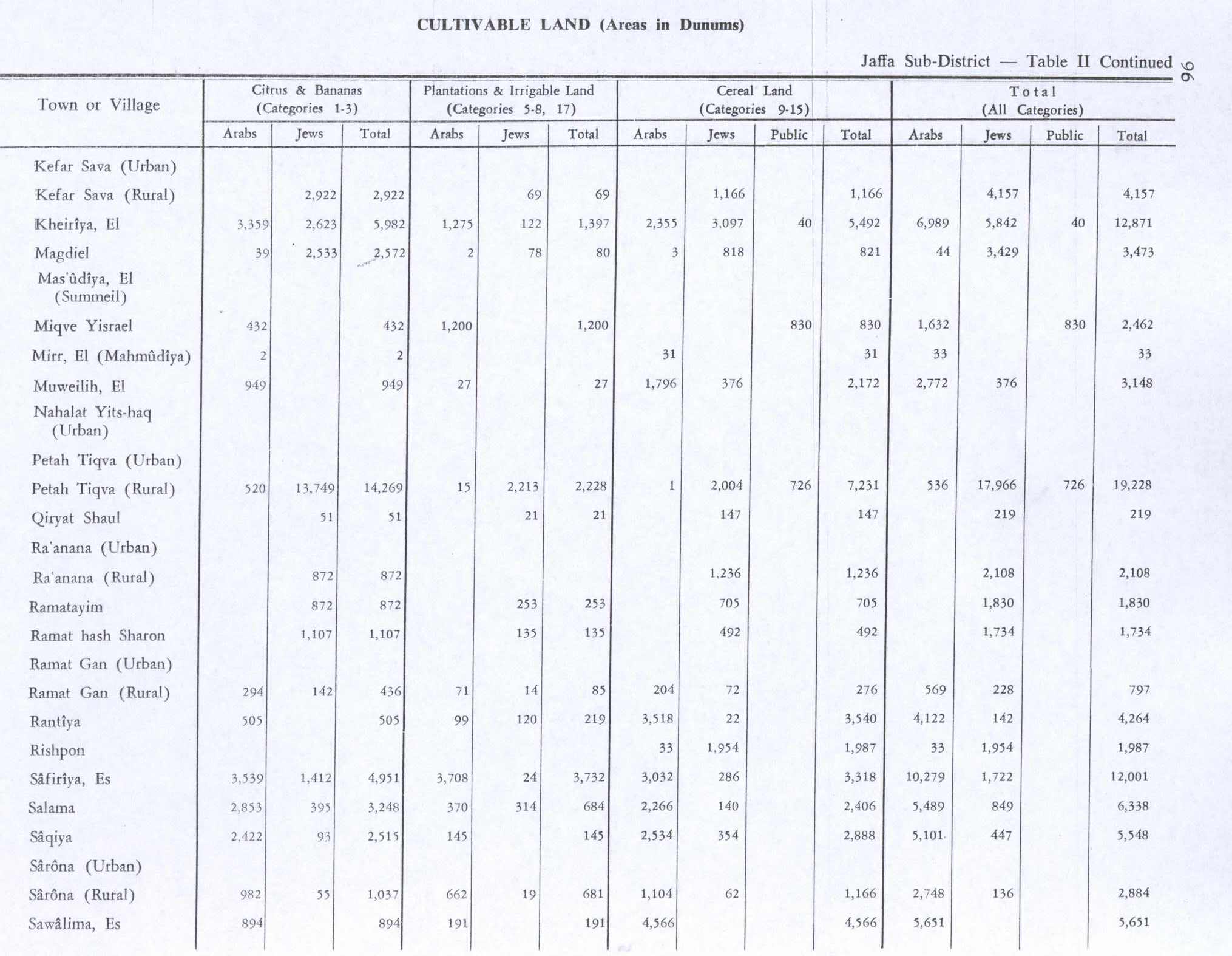
In the 1945 statistics the population numbered 360 Muslims,[1] who had a total of 3,342 dunams of land.[2] Of this, 949 dunums were planted with citrus and bananas, 27 dunums were plantations and irrigable land, 1,796 were for cereals,[5] while a total of 194 dunams were classified as non-cultivable areas.[6]

1948, aftermath[edit]

Neve Yarak is located, partly on Al-Muwaylih land, and partly on land formerly belonging to Jaljuliya.[3]

By 1992, it was described: "The site is very difficult to identify. Some of the houses still stand, deserted, amidst wild vegetation. One of them belonged to Hashim al-Jayyusi, who later became a Jordanian cabinet minister. It is a two-storey, concrete structure with rectangular doors and windows and a stairway in front that leads to the second storey. The other villas have been reduced to rubble. The land in the area is cultivated."[3]

References[edit]

  1. ^ a b Government of Palestine, Department of Statistics, 1945, p. 27
  • ^ a b c Government of Palestine, Department of Statistics. Village Statistics, April, 1945. Quoted in Hadawi, 1970, p. 52
  • ^ a b c Khalidi, 1992, p. 251
  • ^ Mills, 1932, p. 17
  • ^ Government of Palestine, Department of Statistics. Village Statistics, April, 1945. Quoted in Hadawi, 1970, p. 96
  • ^ Government of Palestine, Department of Statistics. Village Statistics, April, 1945. Quoted in Hadawi, 1970, p. 146
  • Bibliography[edit]

    • Government of Palestine, Department of Statistics (1945). Village Statistics, April, 1945.
  • Hadawi, S. (1970). Village Statistics of 1945: A Classification of Land and Area ownership in Palestine. Palestine Liberation Organization Research Center. Archived from the original on 2018-12-08. Retrieved 2009-08-18.
  • Khalidi, W. (1992). All That Remains: The Palestinian Villages Occupied and Depopulated by Israel in 1948. Washington D.C.: Institute for Palestine Studies. ISBN 0-88728-224-5.
  • Mills, E., ed. (1932). Census of Palestine 1931. Population of Villages, Towns and Administrative Areas. Jerusalem: Government of Palestine.
  • External links[edit]


    Retrieved from "https://en.wikipedia.org/w/index.php?title=Al-Muwaylih&oldid=1090345026"

    Categories: 
    Arab villages depopulated during the 1948 ArabIsraeli War
    District of Jaffa
    Hidden categories: 
    Pages using gadget WikiMiniAtlas
    Pages with non-numeric formatnum arguments
    Articles with short description
    Short description matches Wikidata
    Coordinates on Wikidata
    Articles containing Arabic-language text


    This page was last edited on 29 May 2022, at 00:55 (UTC).

    Text is available under the Creative Commons Attribution-ShareAlike License 4.0; additional terms may apply. By using this site, you agree to the Terms of Use and Privacy Policy. Wikipedia® is a registered trademark of the Wikimedia Foundation, Inc., a non-profit organization.


    Privacy policy

    About Wikipedia

    Disclaimers

    Contact Wikipedia

    Code of Conduct

    Developers

    Statistics

    Cookie statement

    Mobile view


    Wikimedia Foundation
    Powered by MediaWiki