Jump to content


Main menu


Navigation  


Main page
Contents
Current events
Random article
About Wikipedia
Contact us
Donate


Contribute  


Help
Learn to edit
Community portal
Recent changes
Upload file


Search  


Create account

Log in


Create account
 Log in


Pages for logged out editors learn more  


Contributions
Talk


Contents


(Top)


1 History  


1.1  British Mandate era  


1.2  1948, and after  


2 References  


3 Bibliography  


4 External links  


Qannir


العربية
Bahasa Indonesia
اردو
 

Edit links


Article
Talk


Read
Edit
View history


Tools


Actions  


Read
Edit
View history


General  


What links here
Related changes
Upload file
Special pages
Permanent link
Page information
Cite this page
Get shortened URL
Download QR code
Wikidata item


Print/export  


Download as PDF
Printable version


In other projects  


Wikimedia Commons


Appearance


Coordinates: 32°3142N 35°0151E / 32.52833°N 35.03083°E / 32.52833; 35.03083
 

From Wikipedia, the free encyclopedia


Qannir
قنْير
Kannir
Village
Etymology: from personal name[1]

1870s map

1940s map

modern map

1940s with modern overlay map

A series of historical maps of the area around Qannir (click the buttons)
Qannir is located in Mandatory Palestine
Qannir

Qannir

Location within Mandatory Palestine

Coordinates: 32°31′42N 35°01′51E / 32.52833°N 35.03083°E / 32.52833; 35.03083
Palestine grid153/214
Geopolitical entityMandatory Palestine
SubdistrictHaifa
Date of depopulation25 April 1948[4]
Area
 • Total10,826 dunams (10.826 km2 or 4.180 sq mi)
Population
 (1945)
 • Total750[2][3]
Cause(s) of depopulationInfluence of nearby town's fall
Secondary causeFear of being caught up in the fighting
Current LocalitiesRegavim[5]

Qannir (Arabic: قنْير) was a Palestinian village, located 35 kilometers south of Haifa. With 750 inhabitants in 1945, it was depopulated in the lead up to the 1948 Arab-Israeli war.

History[edit]

In the late Ottoman era, Qannir appears on sheet 45 of Jacotin's map drawn-up during Napoleon's invasion in 1799.[6][7]

In 1859, the English consul Rogers estimated the population to be 250, who cultivated 24 feddans of land. By 1882, PEF's Survey of Western Palestine described the place as a village of adobe of moderate size, with one well to the south, and another to the west.[8] By a later account, the village consisted of stone houses built side by side.[5]

A population list from about 1887 showed that el Kannir had about 665 inhabitants, all Muslim.[9]

British Mandate era[edit]

In the 1922 census of Palestine, conducted by the British Mandate authorities, Qannir had a population of 400; all Muslims,[10] increasing slightly in the 1931 census to 483, still all Muslims, in a total of 92 houses.[11]

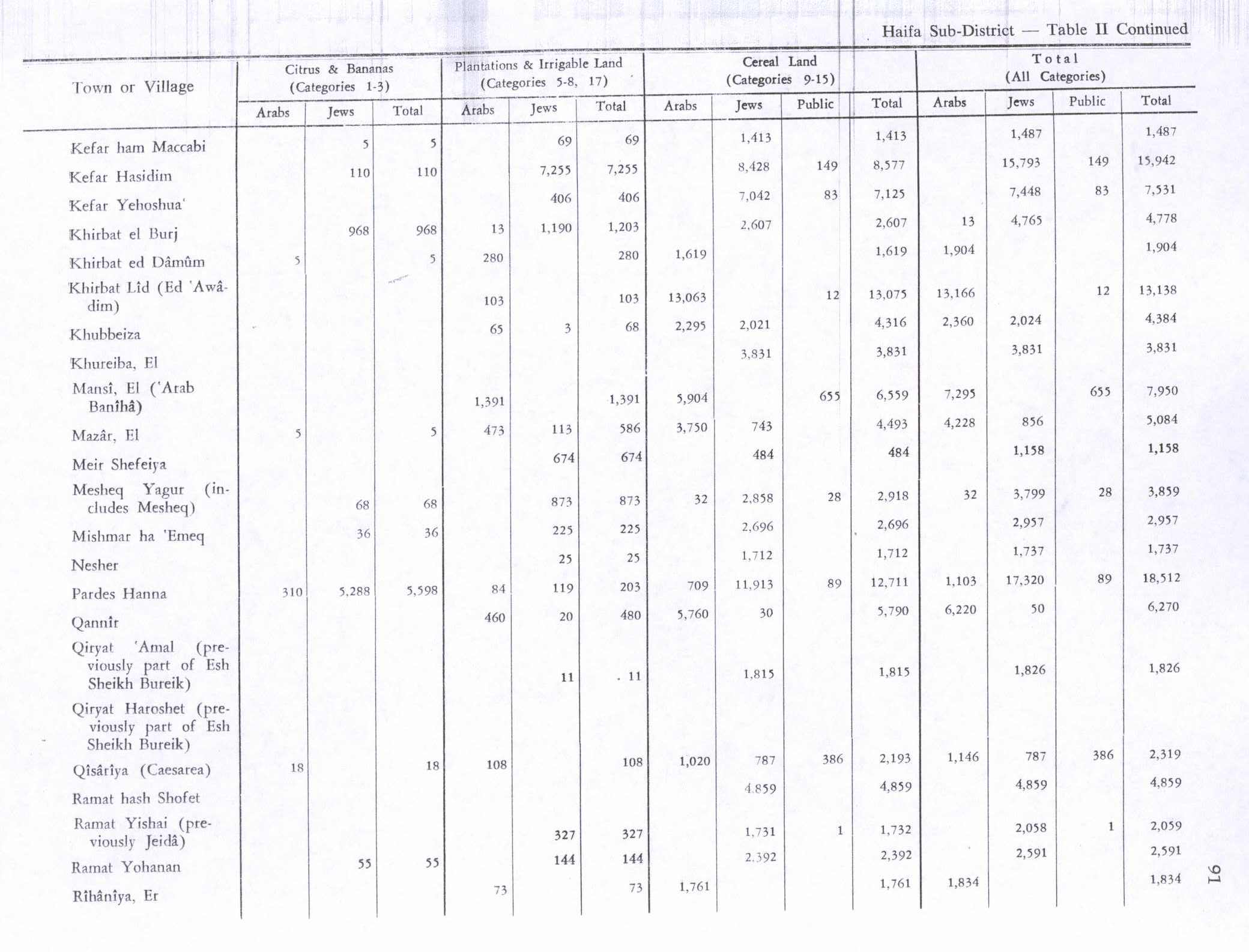
In the 1945 statistics the population was 750 Muslims[2] with 10,826 dunums of land.[3] Of this, a total of 5,760 dunums were used for cereals; while 460 dunums were irrigated or used for orchards,[5][12] while 22 dunams were built-up (urban) land.[13]

1948, and after[edit]

Between 22–24 April 1948, the women and children of Qannir started to evacuate the village, apparently on [Arab] "orders from on high".[14][15]

According to a dispatch sent by Fawzi al-Qawuqji to the [Arab] High Command, an enemy attack from Ein Hashofeit started on 0400 on 8 May towards Quannir and Kafr Quari. The attackers were supported by armored cars. According to al-Qawuqji the attack was "resisted and repelled", with a result of one killed and four wounded on the Palestinian side.[16]

However, according to Haganah sources, the forces of the Alexandroni Brigade "raided the village on 9 May 1948, killed four Arabs and blew up 55 houses".[17] According to Morris, the remaining villagers probably left at this time.[18] Following the war the area was incorporated into the State of Israel, with the kibbutzofRegavim established on the village's former lands in 1949.[5]

Khalidi described the place in 1992:

Stone rubble is strewn about the site, which is covered with thorns, fig trees, and cactus. Part of the adjacent land is used by Israelis as pasture and the other part is cultivated.[5]

References[edit]

  1. ^ Palmer, 1881, p. 147
  • ^ a b Government of Palestine, Department of Statistics, 1945, p. 14
  • ^ a b c Government of Palestine, Department of Statistics. Village Statistics, April, 1945. Quoted in Hadawi, 1970, p. 48
  • ^ Morris, 2004, p. xviii village #171. Also gives causes of depopulation
  • ^ a b c d e Khalidi, 1992, p.181
  • ^ Palestine Exploration Quarterly Jan-Apr 1944. Jacotin's Map of Palestine. D.H.Kellner. p. 161.
  • ^ Karmon, 1960, p. 169 Archived 22 December 2019 at the Wayback Machine
  • ^ Conder and Kitchener, 1882, SWP II, p.42. Cited in Khalidi, 1992, p. 181.
  • ^ Schumacher, 1888, p. 180
  • ^ Barron, 1923, Table XI, Sub-district of Haifa, p. 34
  • ^ Mills, 1932, p. 94
  • ^ Government of Palestine, Department of Statistics. Village Statistics, April, 1945. Quoted in Hadawi, 1970, p. 91
  • ^ Government of Palestine, Department of Statistics. Village Statistics, April, 1945. Quoted in Hadawi, 1970, p. 141
  • ^ Morris, 2004, p. 175, note 67: "Summary of Intelligence for Alexandroni Brigade" (11.5.48), No. 8´IDFA (=Israel Defense Forces and Defence Ministry Archive) 2506\49\\80.
  • ^ Morris, 2004, p. 244 note 623: Tiroshi (Eitan)´to HIS-AD, 29 Apr. 1948, HA 105\257; and HIS-AD (=Haganah Intelligence Service -Arab Department) Information 29.4.48. IDFA 922\75\\1205.
  • ^ al-Qawuqji, 1972, "Memoirs, 1948, Part II" Archived 18 July 2011 at the Wayback Machine, Dispatch 9/5 1948, Quoted in Khalidi, 1992, p. 181
  • ^ Morris, 2004, p. 244, note 624: Tiroshi (Eitan)´to HIS-AD, 3 May 1948, IDFA 6400\49\\66; and Logbook, entry for 9 May 1948, IDFA 665\51\\1.
  • ^ Morris, 2004, p. 244
  • Bibliography[edit]

    • Barron, J.B., ed. (1923). Palestine: Report and General Abstracts of the Census of 1922. Government of Palestine.
  • Conder, C.R.; Kitchener, H.H. (1882). The Survey of Western Palestine: Memoirs of the Topography, Orography, Hydrography, and Archaeology. Vol. 2. London: Committee of the Palestine Exploration Fund.
  • Government of Palestine, Department of Statistics (1945). Village Statistics, April, 1945.
  • Hadawi, S. (1970). Village Statistics of 1945: A Classification of Land and Area ownership in Palestine. Palestine Liberation Organization Research Center.
  • Kallner, D.H. (1944). "Jacotin's Map of Palestine". Quarterly Statement - Palestine Exploration Fund. 76: 157–163. doi:10.1179/peq.1944.76.1.157.
  • Karmon, Y. (1960). "An Analysis of Jacotin's Map of Palestine" (PDF). Israel Exploration Journal. 10 (3, 4): 155–173, 244–253. Archived from the original (PDF) on 22 December 2019. Retrieved 15 April 2015.
  • Khalidi, W. (1992). All That Remains: The Palestinian Villages Occupied and Depopulated by Israel in 1948. Washington D.C.: Institute for Palestine Studies. ISBN 0-88728-224-5.
  • Mills, E., ed. (1932). Census of Palestine 1931. Population of Villages, Towns and Administrative Areas. Jerusalem: Government of Palestine.
  • Morris, B. (2004). The Birth of the Palestinian Refugee Problem Revisited. Cambridge University Press. ISBN 978-0-521-00967-6.
  • Palmer, E.H. (1881). The Survey of Western Palestine: Arabic and English Name Lists Collected During the Survey by Lieutenants Conder and Kitchener, R. E. Transliterated and Explained by E.H. Palmer. Committee of the Palestine Exploration Fund.
  • al-Qawuqji, F. (1972): Memoirs of al-Qawuqji, FauziinJournal of Palestine Studies
  • Schumacher, G. (1888). "Population list of the Liwa of Akka". Quarterly Statement - Palestine Exploration Fund. 20: 169–191.
  • External links[edit]


    Retrieved from "https://en.wikipedia.org/w/index.php?title=Qannir&oldid=1207430068"

    Categories: 
    Arab villages depopulated prior to the 1948 ArabIsraeli War
    District of Haifa
    Hidden categories: 
    Pages using gadget WikiMiniAtlas
    Pages with non-numeric formatnum arguments
    Webarchive template wayback links
    Use dmy dates from April 2015
    Articles with short description
    Short description is different from Wikidata
    Coordinates on Wikidata
    Articles containing Arabic-language text


    This page was last edited on 14 February 2024, at 20:23 (UTC).

    Text is available under the Creative Commons Attribution-ShareAlike License 4.0; additional terms may apply. By using this site, you agree to the Terms of Use and Privacy Policy. Wikipedia® is a registered trademark of the Wikimedia Foundation, Inc., a non-profit organization.


    Privacy policy

    About Wikipedia

    Disclaimers

    Contact Wikipedia

    Code of Conduct

    Developers

    Statistics

    Cookie statement

    Mobile view


    Wikimedia Foundation
    Powered by MediaWiki