Jump to content


Main menu


Navigation  


Main page
Contents
Current events
Random article
About Wikipedia
Contact us
Donate


Contribute  


Help
Learn to edit
Community portal
Recent changes
Upload file


Search  


Create account

Log in


Create account
 Log in


Pages for logged out editors learn more  


Contributions
Talk


Contents


(Top)


1 History  


1.1  Ottoman period  


1.2  British Mandate era  


1.3  1948, and after  


2 Gallery  


3 See also  


4 References  


5 Bibliography  


6 External links  


Jarisha


العربية
Français
Bahasa Indonesia
עברית
مصرى
اردو
 

Edit links


Article
Talk


Read
Edit
View history


Tools


Actions  


Read
Edit
View history


General  


What links here
Related changes
Upload file
Special pages
Permanent link
Page information
Cite this page
Get shortened URL
Download QR code
Wikidata item


Print/export  


Download as PDF
Printable version


In other projects  


Wikimedia Commons


Appearance


Coordinates: 32°543N 34°4828E / 32.09528°N 34.80778°E / 32.09528; 34.80778
 

From Wikipedia, the free encyclopedia


Jarisha
جرِيشة
Jerisha, Jarush
Old mill at Jarisha, about 1917
Etymology: Jerisheh, from "to pound" or "grind"[1]

1870s map

1940s map

modern map

1940s with modern overlay map

A series of historical maps of the area around Jarisha (click the buttons)
Jarisha is located in Mandatory Palestine
Jarisha

Jarisha

Location within Mandatory Palestine

Coordinates: 32°5′43N 34°48′28E / 32.09528°N 34.80778°E / 32.09528; 34.80778
Palestine grid132/167
Geopolitical entityMandatory Palestine
SubdistrictJaffa
Area
 • Total555 dunams (55.5 ha or 137 acres)
Population
 (1945)
 • Total190[2][3]
Current LocalitiesYarkon Park, Tel Aviv,[4] Ramat Gan

Jarisha (Arabic: جرِيشة, also transliterated Jerisha; Hebrew: ג'רישה) was a Palestinian Arab village located 200 meters (660 ft) from the ancient site of Tell Jarisha (Tel Gerisa), on the south bank of Al-Awja (Yarkon River).[5][6] After the establishment of Tel Aviv, it was one of five Arab villages to fall within its municipal boundaries.[4] Jarisha was depopulated in the lead up to the 1948 Arab-Israeli war.[6]

History[edit]

Jarisha was located only 200 meters (660 ft) from Tel Gerisa, an archaeological site dating to the Early Bronze II period (2800-2600 BC). In the Middle Bronze period (2000-1500 BC) the site was a fortified Hyksos town. It was succeeded by a Philistine settlement around the 12th century BC.[7]

Ottoman period[edit]

In the 1596 tax records under the Ottoman Empire, it was a village in the nahiya ("subdistrict") of the Bani Sa'b, part of Nablus Sanjak. It had a population of 22 Muslim households; an estimated 121 persons, who paid taxes on buffalo, goats and beehives; a total of 2,150 akçe.[8]

In 1856 the village was named DarishahonKiepert's map of Palestine published that year.[9] An Ottoman village list from about 1870 showed that the village had a population of 76 in a total of 38 houses, though that population count included men, only. It was further noted that it was located 6000 meters NE of Jaffa.[10][11]

In 1882 the PEF's Survey of Western Palestine (SWP) described the village, transcribed as "Jerisheh", as being built of adobe bricks and flanked by an olive grove. It had a well and a mill.[12] South-east of the village was the ruins of a Khan, a graveyard and some caves, also a masonry dam and a small bridge, "apparently Saracenic".[13]

British Mandate era[edit]

In the 1922 census of Palestine conducted by the British Mandate authorities, Jerisheh had a population of 57, all Muslims[14] increasing by the 1931 census to 183, still all Muslims, in a total of 43 houses.[15]

Since May 1944, Jarisha was part of the municipality of Ramat Gan.[16]

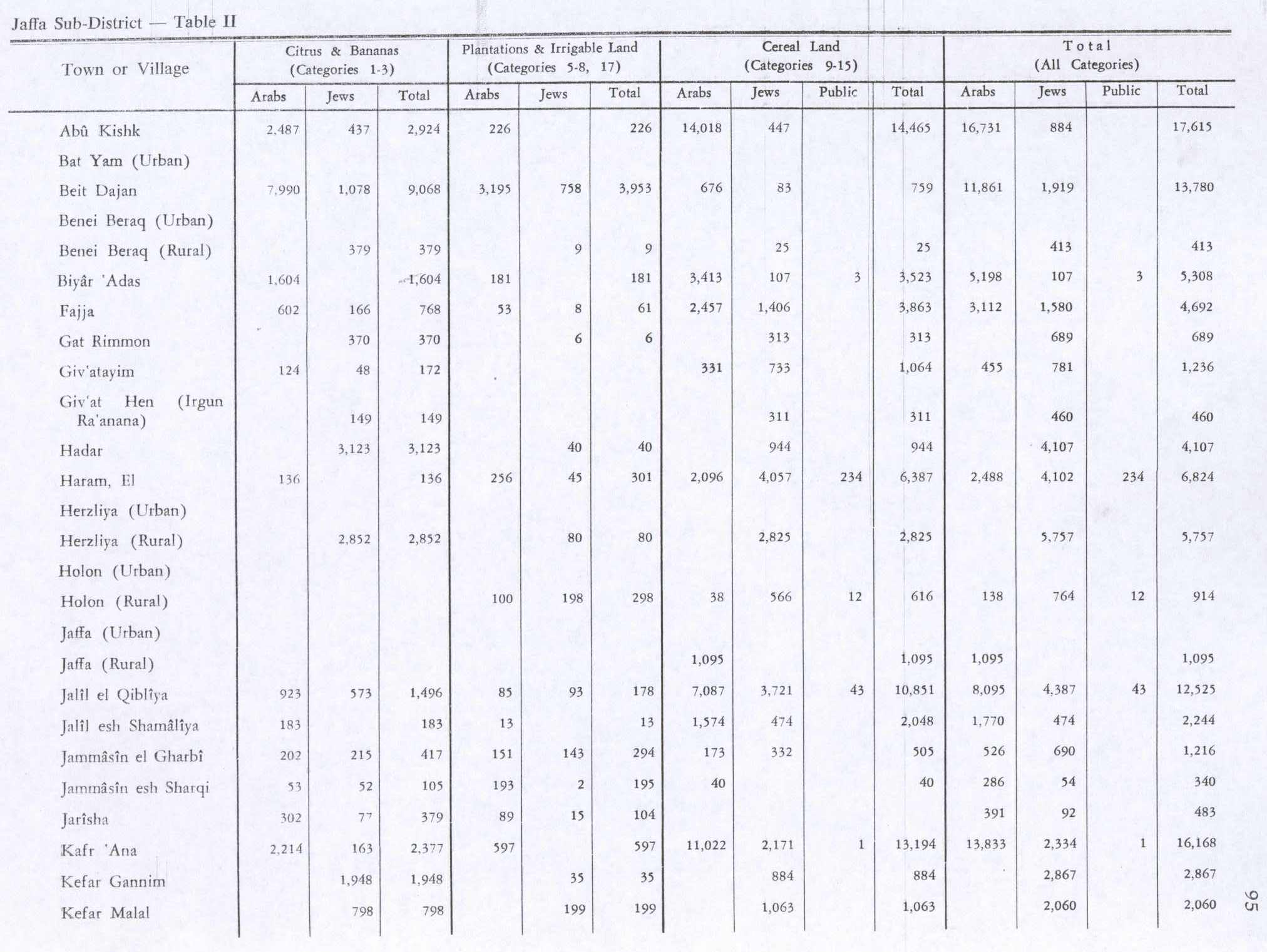
In the 1945 statistics it had a population of 190 Muslims,[3] with 555 dunams of land.[2] The villagers worked in the service industry, but some also grew fruits and vegetables; in 1944-45 a total of 302 dunums of village land was used for citrus and bananas, and 89 dunums were irrigated or used for orchards.[17] 3 dunams were classified as built-up areas.[18]

1948, and after[edit]

According to the Palestinian historian Walid Khalidi, the state of the village site in 1992 was as follows: "The site has been completely covered over by highways and suburban houses."[19]

Gallery[edit]

See also[edit]

References[edit]

  1. ^ Palmer, 1881, p. 215
  • ^ a b c Government of Palestine, Department of Statistics. Village Statistics, April, 1945. Quoted in Hadawi, 1970, p. 52
  • ^ a b Department of Statistics, 1945, p. 27
  • ^ a b Mann, 2006, p. 246.
  • ^ Ben-Tor and Greenberg, 1992, p. 246.
  • ^ a b Khalidi and Elmusa, 1992, p. 246.
  • ^ Khalidi, 1992, p. 246
  • ^ Hütteroth and Abdulfattah, 1977, p. 139; cited in Khalidi, 1992, p. 246
  • ^ Kiepert, 1856, Map of Southern Palestine
  • ^ Deschelscheh, in Socin, 1879, p. 152
  • ^ Hartmann, 1883, p. 137, also noted 38 houses at el−dscherische
  • ^ Conder and Kitchener, 1882, SWP II, p. 251. Quoted in Khalidi, 1992, p.246
  • ^ Conder and Kitchener, 1882, SWP II, p. 265
  • ^ Barron, 1923, Table VII, Sub-district of Jaffa, p. 20
  • ^ Mills, 1932, p. 14
  • ^ "⁨במושבות ⁩ | ⁨הארץ⁩ | 14 מאי 1944 | אוסף העיתונות | הספרייה הלאומית".
  • ^ Government of Palestine, Department of Statistics. Village Statistics, April, 1945. Quoted in Hadawi, 1970, p. 95 Also in Khalidi, 1992, p.246-247
  • ^ Government of Palestine, Department of Statistics. Village Statistics, April, 1945. Quoted in Hadawi, 1970, p. 145
  • ^ Khalidi, 1992, p. 247
  • Bibliography[edit]

    • Ben-Tor, Amnon; Greenberg, R. (1992). The archaeology of ancient Israel.
  • Barron, J.B., ed. (1923). Palestine: Report and General Abstracts of the Census of 1922. Government of Palestine.
  • Clermont-Ganneau, C.S. (1895). Études d'archéologie orientale (in French). Paris: E. Bouillon. (pp. 192−196: "Les Trois−Ponts, Jorgilia")
  • Conder, C.R.; Kitchener, H.H. (1882). The Survey of Western Palestine: Memoirs of the Topography, Orography, Hydrography, and Archaeology. Vol. 2. London: Committee of the Palestine Exploration Fund.
  • Department of Statistics (1945). Village Statistics, April, 1945. Government of Palestine.
  • Hadawi, S. (1970). Village Statistics of 1945: A Classification of Land and Area ownership in Palestine. Palestine Liberation Organization Research Center.
  • Hartmann, M. (1883). "Die Ortschaftenliste des Liwa Jerusalem in dem türkischen Staatskalender für Syrien auf das Jahr 1288 der Flucht (1871)". Zeitschrift des Deutschen Palästina-Vereins. 6: 102–149.
  • Hütteroth, Wolf-Dieter; Abdulfattah, Kamal (1977). Historical Geography of Palestine, Transjordan and Southern Syria in the Late 16th Century. Erlanger Geographische Arbeiten, Sonderband 5. Erlangen, Germany: Vorstand der Fränkischen Geographischen Gesellschaft. ISBN 3-920405-41-2.
  • Khalidi, W. (1992). All That Remains: The Palestinian Villages Occupied and Depopulated by Israel in 1948. Washington D.C.: Institute for Palestine Studies. ISBN 0-88728-224-5. ISBN 0-88728-224-5.
  • Mann, Barbara E. (2006). A Place in History: Modernism, Tel Aviv, and the Creation of Jewish Urban Space. Stanford University Press. ISBN 978-0-8047-5019-6. ISBN 0-8047-5019-X.
  • Mills, E., ed. (1932). Census of Palestine 1931. Population of Villages, Towns and Administrative Areas. Jerusalem: Government of Palestine.
  • Morris, B. (2004). The Birth of the Palestinian Refugee Problem Revisited. Cambridge University Press. ISBN 0-521-00967-7.
  • Palmer, E.H. (1881). The Survey of Western Palestine: Arabic and English Name Lists Collected During the Survey by Lieutenants Conder and Kitchener, R. E. Transliterated and Explained by E.H. Palmer. Committee of the Palestine Exploration Fund.
  • Socin, A. (1879). "Alphabetisches Verzeichniss von Ortschaften des Paschalik Jerusalem". Zeitschrift des Deutschen Palästina-Vereins. 2: 135–163.
  • External links[edit]


    Retrieved from "https://en.wikipedia.org/w/index.php?title=Jarisha&oldid=1230321083"

    Categories: 
    District of Jaffa
    Arab villages depopulated prior to the 1948 ArabIsraeli War
    Hidden categories: 
    Pages using gadget WikiMiniAtlas
    Pages with non-numeric formatnum arguments
    Articles with short description
    Short description is different from Wikidata
    Coordinates on Wikidata
    Articles containing Arabic-language text
    Articles containing Hebrew-language text
    CS1 French-language sources (fr)


    This page was last edited on 22 June 2024, at 01:43 (UTC).

    Text is available under the Creative Commons Attribution-ShareAlike License 4.0; additional terms may apply. By using this site, you agree to the Terms of Use and Privacy Policy. Wikipedia® is a registered trademark of the Wikimedia Foundation, Inc., a non-profit organization.


    Privacy policy

    About Wikipedia

    Disclaimers

    Contact Wikipedia

    Code of Conduct

    Developers

    Statistics

    Cookie statement

    Mobile view


    Wikimedia Foundation
    Powered by MediaWiki