Jump to content


Main menu


Navigation  


Main page
Contents
Current events
Random article
About Wikipedia
Contact us
Donate


Contribute  


Help
Learn to edit
Community portal
Recent changes
Upload file


Search  


Create account

Log in


Create account
 Log in


Pages for logged out editors learn more  


Contributions
Talk


Contents


(Top)


1 History  


1.1  British Mandate era  


1.2  1948, aftermath  


2 References  


3 Bibliography  


4 External links  


Khiyam al-Walid


العربية
فارسی
Bahasa Indonesia
اردو
 

Edit links


Article
Talk


Read
Edit
View history


Tools


Actions  


Read
Edit
View history


General  


What links here
Related changes
Upload file
Special pages
Permanent link
Page information
Cite this page
Get shortened URL
Download QR code
Wikidata item


Print/export  


Download as PDF
Printable version


Appearance


Coordinates: 33°0839N 35°3914E / 33.14417°N 35.65389°E / 33.14417; 35.65389
 

From Wikipedia, the free encyclopedia


Khiyam al-Walid
خيام الوليد
Village
Khiyam al-Walid was located on the eastern edge of the Hula Valley
Etymology: "the tents of al-Walid"

1870s map

1940s map

modern map

1940s with modern overlay map

A series of historical maps of the area around Khiyam al-Walid (click the buttons)
Khiyam al-Walid is located in Mandatory Palestine
Khiyam al-Walid

Khiyam al-Walid

Location within Mandatory Palestine

Coordinates: 33°08′39N 35°39′14E / 33.14417°N 35.65389°E / 33.14417; 35.65389
Palestine grid211/282
Geopolitical entityMandatory Palestine
SubdistrictSafad
Date of depopulationMay 1, 1948[3]
Area
 • Total4,215 dunams (4.215 km2 or 1.627 sq mi)
Population
 (1945)
 • Total280[1][2]
Cause(s) of depopulationFear of being caught up in the fighting
Current LocalitiesLehavot HaBashan[4]

Khiyam al-Walid (Arabic: خيام الوليد) was a Palestinian Arab village in the Safad Subdistrict located 25.5 kilometers (15.8 mi) northeast of Safad along the Syrian border. It was on situated on a hill 150 meters (490 ft) above sea level on the eastern edge of the Hula Valley. In 1945, there were 280 predominantly Muslim inhabitants. It was depopulated during the 1948 Palestine War.[4]

History[edit]

The name of the village in Arabic is translated as "the tents of al-Walid", which may refer to the Arab Muslim commander Khalid ibn al-Walid (d. 642).[4] According to local tradition, a shrine and the tomb of the sage Shaykh ibn al-Walid was located in the village mosque.[4]

British Mandate era[edit]

In the 1931 census of Palestine the population of Khiyam al-Walid was 181, all Muslims, in a total of 42 houses.[5]

Khiyam al Walid was classified as a hamlet by the Palestine Index Gazeteer. During the British Mandate period, many of the houses were situated along the road to the nearby village of az-Zawiya. There was a good water source to the east, and the village consequently expanded in that direction. In a 1945 survey, the village was made up of a total 4,215 dunams. Despite its entire population being Arab, 92% of its land was Jewish-owned.[4]

Types of land use in dunams in the village in the 1945 statistics:[6][7]

Land Usage Arab Jewish
Irrigated and plantation 153 2,599
Cereal 0 502
Cultivable 153 3,101
Urban
Non-cultivable 8 800

The land ownership of the village before occupation in dunams:[2]

Owner Dunams
Arab 161
Jewish 3,901
Public 153
Total 4,215
Khiyam al-Walid 1945
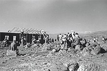
Lehavot HaBashan under construction on Khiyam al-Walid land 1945

1948, aftermath[edit]

According to an Israeli military report in June 1948, the residents fled on May 1 in anticipation of an attack by Israeli forces. It was occupied by the end of may in Operation Yiftach.[8]

Palestinian historian Walid Khalidi wrote of the remains of the village in 1992, saying "The site is deserted and overgrown with grass and thorns. There are a few carob trees, piles of stones, and crumbled terraces."[4]

References[edit]

  1. ^ Department of Statistics, 1945, p. 10
  • ^ a b Government of Palestine, Department of Statistics. Village Statistics, April, 1945. Quoted in Hadawi, Village Statistics, 1945. PLO Research Center, 1970, p.70
  • ^ Morris, 2004, p. xvi, village #22. Also gives cause of depopulation.
  • ^ a b c d e f Khalidi, 1992, p.466.
  • ^ Mills, 1932, p. 107
  • ^ Government of Palestine, Department of Statistics. Village Statistics, April, 1945. Quoted in Hadawi, 1970, p. 119
  • ^ Government of Palestine, Department of Statistics. Village Statistics, April, 1945. Quoted in Hadawi, 1970, p. 169
  • ^ Morris, 2004, pp. 132 note #542 on 160; 249 note #686 on 302
  • Bibliography[edit]

    • Department of Statistics (1945). Village Statistics, April, 1945. Government of Palestine.
  • Hadawi, S. (1970). Village Statistics of 1945: A Classification of Land and Area ownership in Palestine. Palestine Liberation Organization Research Center.
  • Khalidi, W. (1992). All That Remains:The Palestinian Villages Occupied and Depopulated by Israel in 1948. Washington D.C.: Institute for Palestine Studies. ISBN 0-88728-224-5.
  • Mills, E., ed. (1932). Census of Palestine 1931. Population of Villages, Towns and Administrative Areas. Jerusalem: Government of Palestine.
  • Morris, B. (2004). The Birth of the Palestinian Refugee Problem Revisited. Cambridge University Press. ISBN 978-0-521-00967-6.
  • External links[edit]


    Retrieved from "https://en.wikipedia.org/w/index.php?title=Khiyam_al-Walid&oldid=1052622587"

    Categories: 
    Arab villages depopulated during the 1948 ArabIsraeli War
    District of Safad
    Hidden categories: 
    Pages using gadget WikiMiniAtlas
    Pages with non-numeric formatnum arguments
    Articles with short description
    Short description matches Wikidata
    Coordinates on Wikidata
    Articles containing Arabic-language text


    This page was last edited on 30 October 2021, at 06:16 (UTC).

    Text is available under the Creative Commons Attribution-ShareAlike License 4.0; additional terms may apply. By using this site, you agree to the Terms of Use and Privacy Policy. Wikipedia® is a registered trademark of the Wikimedia Foundation, Inc., a non-profit organization.


    Privacy policy

    About Wikipedia

    Disclaimers

    Contact Wikipedia

    Code of Conduct

    Developers

    Statistics

    Cookie statement

    Mobile view


    Wikimedia Foundation
    Powered by MediaWiki