Jump to content


Main menu


Navigation  


Main page
Contents
Current events
Random article
About Wikipedia
Contact us
Donate


Contribute  


Help
Learn to edit
Community portal
Recent changes
Upload file


Search  


Create account

Log in


Create account
 Log in


Pages for logged out editors learn more  


Contributions
Talk


Contents


(Top)


1 History  


1.1  Ottoman Empire  


1.2  British Mandate era  


1.3  1948 and aftermath  


2 See also  


3 Footnotes  


4 Bibliography  


5 External links  


Biyar 'Adas


العربية
Bahasa Indonesia
עברית
مصرى
اردو
 

Edit links


Article
Talk


Read
Edit
View history


Tools


Actions  


Read
Edit
View history


General  


What links here
Related changes
Upload file
Special pages
Permanent link
Page information
Cite this page
Get shortened URL
Download QR code
Wikidata item


Print/export  


Download as PDF
Printable version


In other projects  


Wikimedia Commons


Appearance


Coordinates: 32°0927N 34°5515E / 32.15750°N 34.92083°E / 32.15750; 34.92083
 

From Wikipedia, the free encyclopedia


Biyar 'Adas
بِيار عدس
Bir Adas
"Shanti" house, ca 1948
Etymology: "The well of lentils"[1]

1870s map

1940s map

modern map

1940s with modern overlay map

A series of historical maps of the area around Biyar 'Adas (click the buttons)
Biyar 'Adas is located in Mandatory Palestine
Biyar 'Adas

Biyar 'Adas

Location within Mandatory Palestine

Coordinates: 32°09′27N 34°55′15E / 32.15750°N 34.92083°E / 32.15750; 34.92083
Palestine grid142/173
Geopolitical entityMandatory Palestine
SubdistrictJaffa
Date of depopulationApril 12, 1948[4]
Area
 • Total5,492 dunams (5.492 km2 or 2.120 sq mi)
Population
 (1945)
 • Total300[2][3]
Cause(s) of depopulationMilitary assault by Yishuv forces
Current LocalitiesAdanim,[5] Elishama[5]

Biyar 'Adas (Arabic: بِيار عدس) was a Palestinian Arab village located 19 km northeast of the city of Tel Aviv. In 1945 the village had a population of 300 and a total land area of 5,492 dunums.

History[edit]

Ottoman Empire[edit]

In 1856 the village was named Bir 'AdasonKiepert's map of Palestine published that year.[6]

In 1870 Victor Guérin noted it as located on a small height,[7] and an Ottoman village list from about the same year showed that Bijar 'Adas had a population of 198 in a total of 60 houses, though that population count included men, only. It was further noted that the name meant "The cisternoflentils".[8][9]

In 1882, the PEF's Survey of Western Palestine (SWP) described Biyar 'Adas as a village built of adobe bricks, with a well to the east.[10]

British Mandate era[edit]

In the 1922 census of Palestine, conducted by the British Mandate authorities, Biar Adas had a population of 87, all Muslims,[11] increasing in the 1931 census to 161, still all Muslim, in a total of 28 houses.[12]

In the early hours of May 29, 1939, 25 members of the Irgun led by Moshe Moldovsky attacked Biyar 'Adas on the grounds that its residents were harboring what they have seen as "gangs". The members of the unit were instructed to avoid harming women, children and the elderly.[13][14] They forced their way into two houses and shot dead one man and four women.[13] Two men and a girl were wounded.[13] In a letter, Ze'ev Jabotinsky ordered the Irgun command to punish those responsible for shooting women, and to report to him what the punishment was, if indeed those reports were true.[14] Nobody was punished.[14]

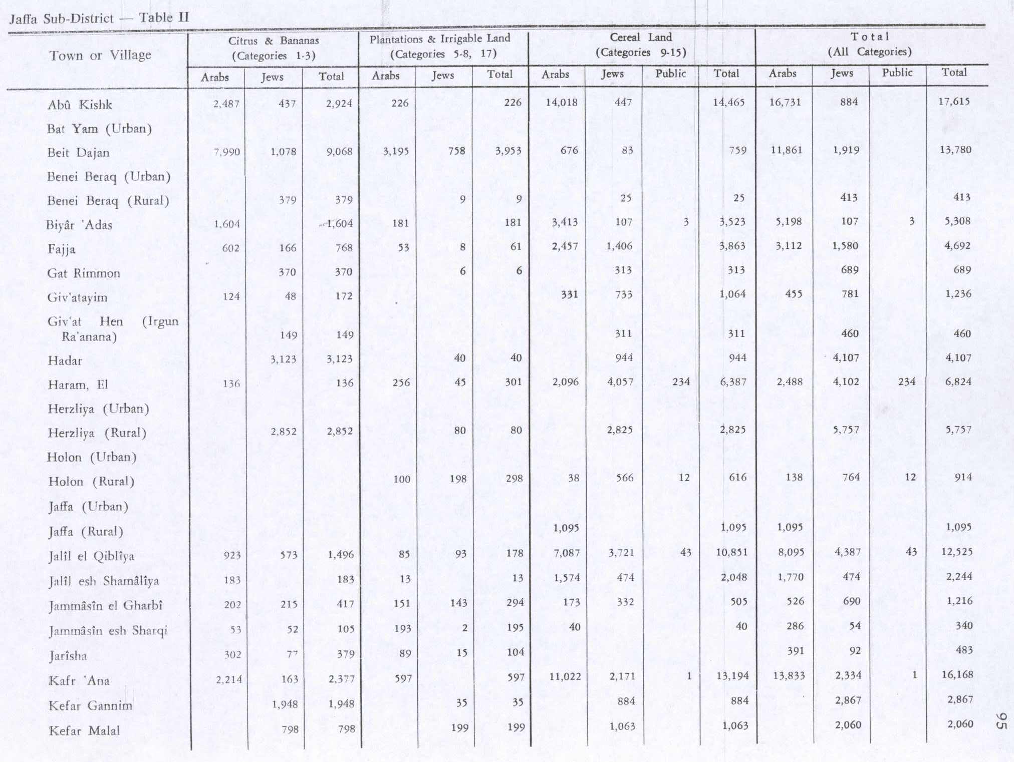
In the 1945 statistics the village had a total of 1,604 dunums of land used for citrus and bananas, 3,413 dunums to cereals, 181 dunums were irrigated or used for orchards,[5][15] while 14 dunams were classified as built-up areas.[16]

Biyar 'Adas 1942 1:20,000
Biyar 'Adas 1945 1:250,000

1948 and aftermath[edit]

On January 19, 1948, the elders of Biyar Adas warned the inhabitants of the nearby Jewish settlement of Magdiel to be on guard against assaults.[17] On February 27 that year, a farmer from Magdiel was killed in an ambush by Arab militants while working in fields near Magdiel. A Israel Defense Forces force from the 32nd Battalion of the Alexandroni Brigade arrived to the scene of the shooting, spotted militants retreating towards Bir Adas, and opened fire on the village. Following the shooting, on March 2 1948, Iraqi troops, who were headed by Fawzi al-Qawuqji, were called to Biyar Adas and attacked Magdiel. Fire and sniping took place daily for about a week. Company B of the 32nd Battalion of the Alexandroni Brigade attempted to hit Arab positions, as additional Arab forces were concentrated in Bir Adas. A prolonged battle ensued, which ended with withdrawal of the Arab troops[18] and a ceasefire, brokered on 9 March 1948 by the Arab notable Tawfiq Abu Kishk.[19][20][21][22]

The village became depopulated after an assault by the Lehi, an offshoot of the Irgun on April 12, 1948.[4][23][24] Later that year, Yosef Weitz set about levelling Biyar 'Adas.[25][26]

After the war the area was incorporated into the State of Israel. The moshavofAdanim was established on village land, southwest of the village site, in 1950. In 1951 another moshav, Elishama, was built on land that had belonged to Biyar 'Adas.[5]

Khalidi described the place in 1992:

The site is marked by cactuses, fig trees, palm trees, and the debris of houses. Some houses and sections of houses that were built among citrus groves still stand, deserted, amidst wild vegetation. All are made of concrete and possess a variety of architectural designs, ranging from the elaborate to the simple. Their roofs are flat, slanted, or gabled, and their doors and windows are rectangular. The land in the vicinity is cultivated and is covered in places by Israeli fruit orchards.[5]

See also[edit]

Footnotes[edit]

  1. ^ Palmer, 1881, p. 214
  • ^ Department of Statistics, 1945, p. 27
  • ^ a b Government of Palestine, Department of Statistics. Village Statistics, April, 1945. Quoted in Hadawi, 1970, p. 52
  • ^ a b Morris, 2004, p. xviii, village #194. Also gives cause of depopulation.
  • ^ a b c d e Khalidi, 1992, p.239
  • ^ Kiepert, 1856, Map of Southern Palestine
  • ^ Guérin, 1875, p. 369
  • ^ Socin, 1879, p. 148
  • ^ Hartmann, 1883, p. 136, also noted 60 houses at Bijar Ades
  • ^ Conder and Kitchener, 1882, SWP II, p. 251. Cited in Khalidi, 1992, p. 238.
  • ^ Barron, 1923, Table VII, Sub-district of Jaffa, p. 20
  • ^ Mills, 1932, p. 13
  • ^ a b c "5 Arabs dead in Outrage". Palestine Post. May 30, 1939. p. 1.
  • ^ a b c Ehud Ein-Gil (January 13, 2009). "'Punish those responsible'". Haaretz.
  • ^ Government of Palestine, Department of Statistics. Village Statistics, April, 1945. Quoted in Hadawi, 1970, p. 95
  • ^ Government of Palestine, Department of Statistics. Village Statistics, April, 1945. Quoted in Hadawi, 1970, p. 145
  • ^ Civil alliances – Palestine, 1947–1948
  • ^ Promise and Fulfilment - Palestine 1917-1949, By Arthur Koestler. Chapter XIV.
  • ^ The Birth of the Palestinian Refugee Problem Revisited. 2nd edition. p.127
  • ^ For the date of the truce, see: Israel: the First Hundred Years: Volume II: From War to Peace?, By Efraim Karsh. p.19, footnote 34.
  • ^ Jewish Telegraphic Agency, News Brief, March 9 1948
  • ^ Alexandroni Brigade in the War of Independence (Hebrew), Gershon Rivlin, Tsevi Sinai. 1992.
  • ^ Morris, 2004, p. 127, note #479, p. 158
  • ^ Morris, 2004, p. 246, notes #639-642, p. 298
  • ^ Morris, 2004, p. 314
  • ^ Morris, 2004, p. 350, note #55, p. 398
  • Bibliography[edit]

  • Conder, C.R.; Kitchener, H.H. (1882). The Survey of Western Palestine: Memoirs of the Topography, Orography, Hydrography, and Archaeology. Vol. 2. London: Committee of the Palestine Exploration Fund.
  • Department of Statistics (1945). Village Statistics, April, 1945. Government of Palestine.
  • Guérin, V. (1875). Description Géographique Historique et Archéologique de la Palestine (in French). Vol. 2: Samarie, pt. 2. Paris: L'Imprimerie Nationale.
  • Hadawi, S. (1970). Village Statistics of 1945: A Classification of Land and Area ownership in Palestine. Palestine Liberation Organization Research Center.
  • Hartmann, M. (1883). "Die Ortschaftenliste des Liwa Jerusalem in dem türkischen Staatskalender für Syrien auf das Jahr 1288 der Flucht (1871)". Zeitschrift des Deutschen Palästina-Vereins. 6: 102–149.
  • Khalidi, W. (1992). All That Remains: The Palestinian Villages Occupied and Depopulated by Israel in 1948. Washington D.C.: Institute for Palestine Studies. ISBN 0-88728-224-5.
  • Mills, E, ed. (1932). Census of Palestine 1931. Population of Villages, Towns and Administrative Areas. Jerusalem: Government of Palestine.
  • Morris, B. (2004). The Birth of the Palestinian Refugee Problem Revisited. Cambridge University Press. ISBN 978-0-521-00967-6.
  • Palmer, E.H. (1881). The Survey of Western Palestine: Arabic and English Name Lists Collected During the Survey by Lieutenants Conder and Kitchener, R. E. Transliterated and Explained by E.H. Palmer. Committee of the Palestine Exploration Fund.
  • Socin, A. (1879). "Alphabetisches Verzeichniss von Ortschaften des Paschalik Jerusalem". Zeitschrift des Deutschen Palästina-Vereins. 2: 135–163.
  • External links[edit]


    Retrieved from "https://en.wikipedia.org/w/index.php?title=Biyar_%27Adas&oldid=1163478710"

    Categories: 
    Arab villages depopulated prior to the 1948 ArabIsraeli War
    District of Jaffa
    Hidden categories: 
    Pages using gadget WikiMiniAtlas
    Pages with non-numeric formatnum arguments
    Articles with short description
    Short description is different from Wikidata
    Coordinates on Wikidata
    Articles containing Arabic-language text
    CS1: long volume value
    CS1 French-language sources (fr)


    This page was last edited on 5 July 2023, at 03:45 (UTC).

    Text is available under the Creative Commons Attribution-ShareAlike License 4.0; additional terms may apply. By using this site, you agree to the Terms of Use and Privacy Policy. Wikipedia® is a registered trademark of the Wikimedia Foundation, Inc., a non-profit organization.


    Privacy policy

    About Wikipedia

    Disclaimers

    Contact Wikipedia

    Code of Conduct

    Developers

    Statistics

    Cookie statement

    Mobile view


    Wikimedia Foundation
    Powered by MediaWiki