
ベンガル地方
(ベンガル州から転送)
| Bengal | |
|---|---|
| বঙ্গ | |
 ベンガル地方の地図 | |
| Coordinates | 北緯24度00分 東経88度00分 / 北緯24.000度 東経88.000度座標: 北緯24度00分 東経88度00分 / 北緯24.000度 東経88.000度 |
| 最大都市[1] |
北緯22度13分 東経91度29分 / 北緯22.22度 東経91.48度 |
| 公用語 | ベンガル語 |
| 面積 | 232,752 km² |
| 人口 (2001) | 245,598,679[2][3] |
| 人口密度 | 951.3/km²[2][3] |
| 乳児死亡率 |
バングラデシュ - 33人/1000人[4] 西ベンガル州 - 31人/1000人[5] |
| 宗教 |
イスラーム教 (68.9%) , ヒンドゥー教 (27.3%) , 仏教 (~3%) , キリスト教 (<1%) |
| 住民の呼称 | ベンガル人 |
| Websites | |
ベンガル地方︵ベンガルちほう、ベンガル語: বঙ্গ、英語: Bengal︶は、ガンジス川とブラマプトラ川の下流にあるデルタ一帯を占め、インドの西ベンガル州とバングラデシュが含まれる、南アジア北東部の地域。歴史的に古い地域で人口も多いが、宗教的対立によって今日ではインドとバングラデシュによって分断されている。世界有数の米とジュートの産地でもある。住民はベンガル人が多く、ベンガル語が話される。
名前の由来[編集]
詳細は「ベンガルの呼称」を参照
「ベンガル」の呼称は13世紀以降にアラブ人、ペルシャ人の間で使われるようになった言葉であり、それをヨーロッパからの植民地会社も使用するようになって広く定着した。それまで使われていたこの地域を示す言葉はベンガル地方の東部を指す「ヴァンガ」と西部の「ガウル」であり、『マハーバーラタ』でもその名が見える。また、その東西を合わせて呼称する時には「バングラ」という言葉が用いられ、それは後のバングラデシュという国名の由来になった[6]。
歴史[編集]
この節は英語版の対応するページを翻訳することにより充実させることができます。(2023年2月) 翻訳前に重要な指示を読むには右にある[表示]をクリックしてください。
●英語版記事を日本語へ機械翻訳したバージョン︵Google翻訳︶。
●万が一翻訳の手がかりとして機械翻訳を用いた場合、翻訳者は必ず翻訳元原文を参照して機械翻訳の誤りを訂正し、正確な翻訳にしなければなりません。これが成されていない場合、記事は削除の方針G-3に基づき、削除される可能性があります。
●信頼性が低いまたは低品質な文章を翻訳しないでください。もし可能ならば、文章を他言語版記事に示された文献で正しいかどうかを確認してください。
●履歴継承を行うため、要約欄に翻訳元となった記事のページ名・版について記述する必要があります。記述方法については、Wikipedia:翻訳のガイドライン#要約欄への記入を参照ください。
●翻訳後、 {{翻訳告知|en|Bengal|…}}をノートに追加することもできます。
●Wikipedia:翻訳のガイドラインに、より詳細な翻訳の手順・指針についての説明があります。
|
詳細は「ベンガル地方の歴史」を参照
古代[編集]


ベンガル地方内ではいくつかの先史時代の遺跡・遺構が見つかっている[7]。紀元前2千年紀頃には、米作を行う集落が域内に点在していた。紀元前11世紀には、ベンガルの人々は計画的にと整えられた住居群に住み、銅器や黒色土器、赤色土器を生産していた。ワリ・ベテシュワール遺跡を始めとした銅器時代の遺跡が見つかっている[8]。鉄器時代が訪れると、人々は鉄製の武器や道具、灌漑設備の使用を始めた[9]。紀元前600年頃からは、古代インドにおける都市化の第二波が北インドに拡がった。この都市化は、同地域における北方黒色磨研土器の定着の一端を担った[10]。この時代には、マハースターンガール、チャンドラケートゥガル、ワリ・ベテシュワールといった都市が築かれた[11]。ガンジス川、ブラマプトラ川、メグナ川は、情報や輸送の動脈として機能した[12]。ベンガル湾の三角州のおかげで、人々は東南アジアやその向こうといった遠方との海上交易を行なっていた[12]。
古代ベンガルには、ヴァレンドラ国、スーマ国、アンガ国、ヴァンガ国、サマタタ国、ハリケラ国といった国があった。これらの国々は、独立状態にあることもあれば、強大な帝国の支配下に置かれることもあった。マハースターン出土のブラーフミー文字の碑文[注釈 1]によれば、紀元前3世紀のベンガルはマウリヤ朝の支配下にあったようである[13]。この碑文は、困窮する住民への救済を指示する行政命令である[13]。また、この地域で発掘されている打刻印銀貨は、鉄器時代を通じ、この地域の通貨として流通していた[14][15]。ベンガルという名前の由来ともなったヴァンガ国は、強大な海軍力と海外での植民活動で知られていた。また、スリランカの歴史書﹃マハーワンサ﹄によれば、ベンガルの王子ウィジャヤはスリランカへと渡り、同地における最初の王国を打ち立てたとされる。 古代のベンガルを支配した帝国として、マウリヤ朝とグプタ帝国が挙げられる。

﹃エリュトゥラー海案内記﹄に記された、1世紀頃の海上交易ルート インド亜大陸東部に見える﹁ガンゲース﹂︵Ganges︶が現在のベンガル地方
ベンガル地方は、ギリシャ人やローマ人からはガンガリダイとして知られていた[16]。 セレウコス朝からの使節としてインドに赴いたギリシャ人、メガステネスは、ガンジス・デルタに覇を唱えたガンガリダイの軍勢について詳しく書き残している。紀元前325年、インドに侵入したアレクサンダー大王の軍勢は、騎兵や戦象を備えたガンガリダイ︵すなわちナンダ朝支配下のマガダ国︶の軍隊によってさらなる侵攻を断念させた[17]。後代のローマの文献、﹃エリュトゥラー海案内記﹄はベンガルとの海上交易ルートについての記録を残している。1世紀に鋳造された、ヘーラクレースの刻印がされたローマ貨幣がベンガル地方で発掘されているが、これは、同地域がローマ属州のエジプトとのあいだに紅海を通じた交易ルートが確立されていたことを示唆している[18]。ワリ・バテシュワール遺跡は、ローマの地理学者、プトレマイオスが﹁ソウナガウラ﹂︵Sounagaura︶として言及したエンポリウム︵交易拠点︶であろうと、現代の考古学者は考えている[19][20]。また、アエラナ︵現在のヨルダン、アカバ︶で4世紀から7世紀頃に製造されたローマ式のアンフォラが、西ベンガル州の東ミドナープル県で出土している[21]。
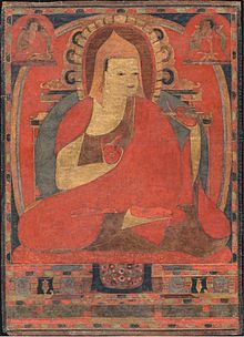
ビクラムプルのアティーシャ 11世紀に活躍
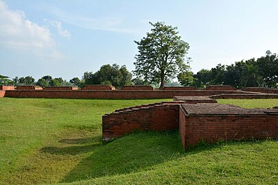
ベンガルを実体として初めて政治的に統一させたのは、ガウダ王国を起したシャシャーンカである。ベンガル暦の起源は、このシャシャーンカ王の時代に遡る。シャシャーンカの死後、ベンガルは﹁マンスヤンヤーヤム﹂、すなわち﹁魚則﹂[注釈 2]の名で知られる内戦の時代を迎えた[23]。古代都市ガウダ︵現在のガウル市、ラクシュマナヴァティーとも︶からは、仏教王朝のパーラ朝が生まれることとなる。パーラ朝の初代皇帝ゴーパーラ1世はガウダの長老たちによって推戴された。パーラ朝は拡大をつづけ、インド亜大陸に覇を争うほどの大帝国となった。パーラ朝の時代には、言語学、彫刻、絵画、学問の分野に発展が見られた。同王朝は、ダルマパーラとデーヴァパーラの時代にその最大版図を支配した。また、カナウジの支配をめぐり、プラティーハーラ朝やラーシュトラクータ朝と抗争を繰り広げた[24]。対外的には、仏教僧アティーシャの説法行脚によってチベットやスマトラ島へ影響が及んだ[25]。ナーランダ僧院のほか、当時インド亜大陸最大の精舎であったソーマプラ僧院が開かれたのもこの時代である。その後、パーラ朝は段階的に衰退した[26]。チャンドラ朝はベンガル南東部とアラカン地方を、ヴァルマン朝はベンガル北西部とアッサム地方を支配した。
11世紀には、パーラ朝に代わってヒンドゥー王朝のセーナ朝がベンガルを支配した。ベンガル地方の大半はセーナ朝の支配下に置かれたが、一部は小国デーヴァ朝が支配した。玄奘をはじめとした、中国からインドを訪れた人々は、ベンガルの諸都市や僧院・精舎について詳しく書き残している[27]。また、サーサーン朝の滅亡と、アラブ人がペルシャ貿易にとって代わったのち、ムスリム商人が貿易のためベンガル地方へと盛んに訪れるようになった。ベンガル地方を訪れた彼らは、ベンガル南東部、メグナ川の東側で交易をおこなった。初期のムスリムはおそらくベンガルを中国航路の経由地として利用していた。また、パハールプルやマイナマティの遺跡ではアッバース朝の貨幣が発掘されている[28]。バングラデシュ国立博物館は、同国で出土したサーサーン朝、ウマイヤ朝、アッバース朝の貨幣を収蔵している[29]。


- 古代のベンガル
-
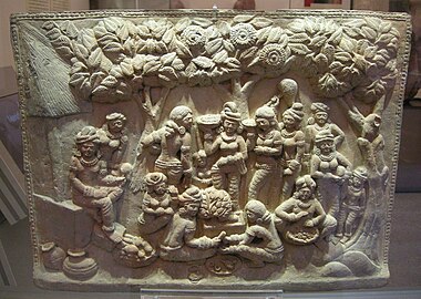 チャンドラケートゥガル出土の釈迦降誕を表したレリーフ
 -

-
-

-
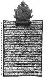 カーリンプル銅板書


デリー・スルターン朝時代[編集]
「ベンガル・スルターン朝」も参照


1204年、ゴール朝の将軍、ムハンマド・バフティヤール・ハルジーがベンガル地方に対する征服活動を開始した[30]。歴史家によれば、ラクナウティは1243年ごろに陥落した。この街は当時、セーナ朝の首都であった。記録によれば、ゴール朝の騎兵はヒンドゥスターン平野を席巻しながらベンガルを目指したという。彼らは馬商人を装ってベンガルの首都に入った。王宮へと入ったハルージーと配下の騎兵たちは、まさに食事を取ろうとして座ったセーナ王の衛兵たちを瞬く間に討ち取った。当の王は、配下の者をともなって森へと逃げ込んだという[31]。このクーデターとも称される政権転覆は、﹁500年以上にわたるムスリムの支配者の時代の幕開けであった。この間、ベンガル地方の大半はムスリムによる支配を受けることとなる。この支配体制自体は例外的なことではなかった。なぜなら、この時期[13世紀]から18世紀までの間、インド亜大陸の大部分はムスリムの君主によって支配されていたのである。しかし、特筆すべきは――おおよそイングランドとスコットランドを合わせたほどの広さを持つ地域である――ベンガル地方だけが、インドの内陸部の地方としては唯一先住民である多数派が支配階級の信仰であるイスラム教を受け入れたことであった﹂[31]。その後、ベンガル地方はデリー・スルターン朝の一地方となる。A coin featuring a horseman was issued to celebrate the Muslim conquest of Lakhnauti with inscriptions in Sanskrit and Arabic. An abortive Islamic invasion of Tibet was also mounted by Bakhtiyar. Bengal was under the formal rule of the Delhi Sultanate for approximately 150 years. Delhi struggled to consolidate control over Bengal. Rebel governors often sought to assert autonomy or independence. Sultan Iltutmish re-established control over Bengal in 1225 after suppressing the rebels. Due to the considerable overland distance, Delhi's authority in Bengal was relatively weak. It was left to local governors to expand territory and bring new areas under Muslim rule, such as through the Conquest of Sylhet in 1303.
In 1338, new rebellions sprung up in Bengal's three main towns. Governors in Lakhnauti, Satgaon and Sonargaon declared independence from Delhi. This allowed the ruler of Sonargaon, Fakhruddin Mubarak Shah, to annex Chittagong to the Islamic administration. By 1352, the ruler of Satgaon, Shamsuddin Ilyas Shah, unified the region into an independent state. Ilyas Shah established his capital in Pandua.[32] The new breakaway state emerged as the Bengal Sultanate, which developed into a territorial, mercantile and maritime empire. At the time, the Islamic world stretched from Muslim Spain in the west to Bengal in the east.
The initial raids of Ilyas Shah saw the first Muslim army enter Nepal and stretched from Varanasi in the west to Orissa in the south to Assam in the east.[33] The Delhi army continued to fend off the new Bengali army. The Bengal-Delhi War ended in 1359 when Delhi recognized the independence of Bengal. Ilyas Shah's son Sikandar Shah defeated Delhi Sultan Firuz Shah Tughluq during the Siege of Ekdala Fort. A subsequent peace treaty recognized Bengal's independence and Sikandar Shah was gifted a golden crown by the Sultan of Delhi.[34] The ruler of Arakan sought refuge in Bengal during the reign of Ghiyasuddin Azam Shah. Jalaluddin Muhammad Shah later helped the Arakanese king to regain control of his throne in exchange for becoming a tributary state of the Bengal Sultanate. Bengali influence in Arakan persisted for 300 years.[35] Bengal also helped the king of Tripura to regain control of his throne in exchange for becoming a tributary state. The ruler of the Jaunpur Sultanate also sought refuge in Bengal.[36] The vassal states of Bengal included Arakan, Tripura, Chandradwip and Pratapgarh. At its peak, the Bengal Sultanate's territory included parts of Arakan, Assam, Bihar, Orissa, and Tripura.[37] The Bengal Sultanate experienced its greatest military success under Alauddin Hussain Shah, who was proclaimed as the conqueror of Assam after his forces led by Shah Ismail Ghazi overthrew the Khen dynasty and annexed large parts of Assam. In maritime trade, the Bengal Sultanate benefited from Indian Ocean trade networks and emerged as a hub of re-exports. A giraffe was brought by African envoys from Malindi to Bengal's court and was later gifted to Imperial China. Ship-owing merchants acted as envoys of the Sultan while travelling to different regions in Asia and Africa. Many rich Bengali merchants lived in Malacca.[38] Bengali ships transported embassies from Brunei, Aceh and Malacca to China. Bengal and the Maldives had a vast trade in shell currency.[39] The Sultan of Bengal donated funds to build schools in the Hejaz region of Arabia.[40]
The five dynastic periods of the Bengal Sultanate spanned from the Ilyas Shahi dynasty, to a period of rule by Bengali converts, to the Hussain Shahi dynasty, to a period of rule by Abyssinian usurpers; an interruption by the Suri dynasty; and ended with the Karrani dynasty. The Battle of Raj Mahal and the capture of Daud Khan Karrani marked the end of the Bengal Sultanate during the reign of Mughal Emperor Akbar. In the late 16th-century, a confederation called the Baro-Bhuyan resisted Mughal invasions in eastern Bengal. The Baro-Bhuyan included twelve Muslim and Hindu leaders of the Zamindars of Bengal. They were led by Isa Khan, a former prime minister of the Bengal Sultanate. By the 17th century, the Mughals were able to fully absorb the region to their empire.
- Sultanate period
-
-
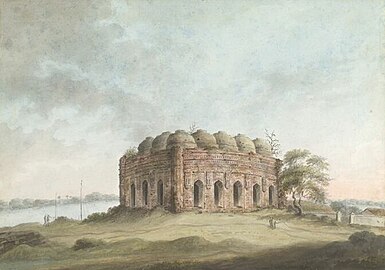 Mosque in the 15th century Bengal style by Sita Ram
 -
-


ムガル帝国時代[編集]
「ベンガル州 (ムガル帝国)」も参照
イギリス植民地時代 (1547年 - 1947年)[編集]
「ベンガル管区」も参照
ベンガル分割[編集]
詳細は「ベンガル分割」を参照
年譜[編集]
●紀元前600年頃 ●マガダ国をはじめとした十六大国が割拠。カーシー国、コーサラ国、ヴィデーハ国を併呑したマガダ国が、紀元前4世紀前半頃まで栄える。 ●紀元前5世紀頃 ●打刻印貨幣流通。 ●-前2世紀 - 都市文化の形成。 ●紀元前364年 - ナンダ朝、ガンジス川流域のほぼ全てを征服。 ●紀元前261年頃 - マウリヤ朝のアショーカ王、インド亜大陸の南端部を除く全域を支配。 ●350年頃 - グプタ朝のサムドラグプタ、ガンジス川流域全域から中部インドを支配。 ●375年頃 - グプタ朝のチャンドラグプタ2世︵- 414年頃︶、北インド全域を支配。 ●7世紀初頭 - ガウダ王国︵金耳国︶のシャシャーンカ王の治世︵- 620年頃︶。 ●623年頃-640年頃 - ヴァルダナ朝のハルシャ・ヴァルダナがベンガル、およびオリッサを征服。 ●672年-685年 - 唐の僧侶、義浄のインド滞在。 ●750年頃 ●パーラ朝興る︵-1170年頃︶。 ●パーラー朝のゴーパーラ1世即位。 ●8世紀後半以降 - ウッジャイニーを拠点とするプラティーハーラ朝が隆盛。パーラ朝・ラーシュトラクター朝と覇権を争う。 ●850年頃 - パーラ朝、デーヴァパーラ王の死後衰退を始める。 ●908年頃 - パーラ朝、ラージヤパーラ即位︵-940年頃︶。 ●992年頃 - パーラ朝、マヒーパーラ1世即位︵-1041年頃︶。パーラ朝が一時的に勢力を盛り返す。 ●10世紀末 - パーラ朝のもとで、貝葉に描く細密仏画がはじまる。 ●1023年頃 - チョーラ朝のラージェーンドラ1世、ガンジス川流域、およびベンガル地方に侵入。マヒーパーラ1世を破る。 ●1077年頃 - パーラ朝、ラーマパーラ即位︵-1120年頃︶。 ●1095年頃 - セーナ朝興る︵13世紀半ば︶。 ●1158年頃 - セーナ朝、バッラーラセーナ即位。都をナディアー︵ノディアとも、現在の西ベンガル︶におく。 ●1162年頃 - パーラ朝滅亡。セーナ朝によるベンガル統一。 ●1198年 - ゴール朝、セーナ朝を破る[41]。
ベンガル・スルターン朝︵1352年 - 1576年︶。
ムガル帝国 (1576年 - 1717年)。
ベンガル太守︵1717年 - 1880年︶、ムルシダーバード太守︵1882年 - 1947年︶。
ベンガル遠征︵1741年 - 1748年︶でマラーター同盟が侵攻してきた。l
イギリス領インド帝国時代にはベンガル管区(1765年 - 1919年)が置かれた。現在の西ベンガル州とバングラデシュの他、ビハール州、オリッサ州、 ジャールカンド州、アッサム州、メーガーラヤ州、ミゾラム州、ナガランド州を含んでいた。
ベンガル大飢饉、人口の3分の1の1千万人が死亡。︵1769年 – 1773年︶
1905年にベンガル分割令が出されたが、1911年にベンガル分割令は撤回された。
1919年、モンタギュー・チェルムスフォード改革。
1937年から1947年まではベンガル自由州が置かれた。(西側の境界は現在の西ベンガル州と若干異なる)
1947年にベンガル分割 (1947年)。イギリスからの独立交渉の際、パキスタン側のムハンマド・アリー・ジンナーはベンガルとパンジャーブ全域のパキスタンへの帰属を要求したが、完全な(インドとの連邦でない)独立と引き換えにベンガルとパンジャーブの分割を呑んで、東ベンガル(1947年 - 1955年)とパンジャーブ州 (パキスタン)がパキスタン領として成立し、西ベンガル州とパンジャーブ州 (インド)はインド領となった。
1955年、東パキスタン︵1955年 - 1971年︶。
1971年、バングラデシュ人民共和国臨時政府(1971年 - 1972年)。
1972年、バングラデシュ。
住民[編集]
66%がイスラーム教徒、33%がヒンドゥー教徒である。 ほぼ全員がベンガル語を話し、わずかな人口がヒンディー語、ウルドゥー語、チャクマ語などを話し、一部の少数民族がサンタル語やネパール語を話す。公式な場では英語もよく使われる。画像[編集]
-
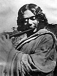
 ラビンドラナート・タゴール、ベンガル・ルネサンスを代表する詩人、小説家
 -

-
 ショヒド・ミナール(ダッカ)
 -
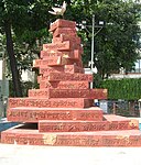 言語の記念碑(コルカタ)
 -
 カジ・ノズルル・イスラム、詩人
 -
 バイトゥル‐ムカロム(ダッカ)
 -
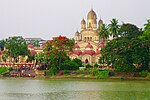 ダクシネーシュワル・カーリー寺院(コルカタ)
 -
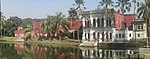 ソーナールガーオン(ナラヤンガンジ)
 -
 ベンガル倶楽部の建物(コルカタ)
 -
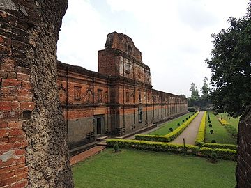
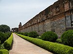 アディナ・モスク(西ベンガル州)
 -


脚注[編集]
注釈[編集]
出典[編集]
(一)^ “THE WORLD; Exiled Feminist Writer Tells Her Own Story”. The New York Times
(二)^ ab“Provisional Population Totals: West Bengal”. Census of India, 2001. Office of the Registrar General & Census Commissioner, India. 2006年8月26日閲覧。
(三)^ abWorld Bank Development Indicators Database, 2006.
(四)^ http://data.worldbank.org/indicator/SP.DYN.IMRT.IN
(五)^ “West Bengal - National Health Mission”. SRS 2011. Ministry of Health & Family Welfare (2011年). 2014年5月12日閲覧。
(六)^ 堀口(2009,35)
(七)^ “Prehistory - Banglapedia”. バングラペディア. 2023年2月10日閲覧。
(八)^ “Wari-Bateshwar: In search of origins” (英語) (2008年8月18日). 2023年2月10日閲覧。
(九)^ “The Rise of Islam and the Bengal Frontier, 1204–1760”. University of California Press (1993年). 2023年2月10日閲覧。
(十)^ 山崎&小西 2007, pp. 42–45.
(11)^ 山崎&小西 2007, p. 47.
(12)^ abEaton, R. M. (1996). The Rise of Islam and the Bengal Frontier, 1204–1760. University of California Press. ISBN 978-0-520-20507-9 2017年1月7日閲覧。
(13)^ abhttps://en.banglapedia.org/index.php/Mahasthan_Brahmi_Inscription
(14)^ “Punch Marked Coins - Banglapedia”. en.banglapedia.org. Banglapedia. 2023年2月11日閲覧。
(15)^ “About Taka Museum” (英語). www.bb.org.bd. バングラデシュ銀行. 2023年2月11日閲覧。
(16)^ Chowdhury, AM. “Gangaridai”. Banglapedia. Asiatic Society of Bangladesh. 2015年6月2日時点のオリジナルよりアーカイブ。2015年8月5日閲覧。
(17)^ 山崎&小西 2007, pp. 103–104.
(18)^ “A Family's Passion - Archaeology Magazine”. www.archaeology.org. 2023年2月15日閲覧。
(19)^ https://discovery.ucl.ac.uk/id/eprint/10081769/1/Man_and_Environment_Bangladesh_Archaeobotany_7_01_2019.pdf
(20)^ “Wari-Bateshwar one of earliest kingdoms”. The Daily Star (2008年3月19日). 2023年2月15日閲覧。
(21)^ Sarkar, Sebanti, "https://scroll.in/magazine/868330/in-rural-bengal-an-indefatigable-relic-hunter-has-uncovered-a-hidden-chapter-of-history Archived 20 February 2018 at the Wayback Machine.." Retrieved 4 August 2018
(22)^ 山崎&小西 2007, p. 202.
(23)^ Matsyanyayam - Banglapedia
(24)^ 山崎&小西 2007, p. 204.
(25)^ 山崎&小西 2007, p. 206.
(26)^ 山崎&小西 2007, pp. 208–211.
(27)^ Hiuen-Tsang - Banglapedia
(28)^ Coins – Banglapedia en.banglapedia.org.
(29)^ “Microsoft Word - 4_H_942 Revised_ Monir m.doc”. 2022年10月9日時点のオリジナルよりアーカイブ。2022年2月6日閲覧。
(30)^ "By the time Muhammad Bakhtiyar conquered northwestern Bengal in 1204"
(31)^ abThe Rise of Islam and the Bengal Frontier, 1204–1760
(32)^ |title=Iliyas Shah - Banglapedia
(33)^ “Iliyas Shah - Banglapedia”. Template:Cite webの呼び出しエラー‥引数 accessdate は必須です。
(34)^ Nitish K. Sengupta (2011). Land of Two Rivers: A History of Bengal from the Mahabharata to Mujib. Penguin Books India. p. 73. ISBN 978-0-14-341678-4.
(35)^ Chowdhury, Mohammed Ali (25 November 2004). Bengal-Arakan Relations, 1430-1666 A.D.. Firma K.L.M.. ISBN 9788171021185
(36)^ Perween Hasan (2007). Sultans and Mosques: The Early Muslim Architecture of Bangladesh. I.B.Tauris. pp. 16–17. ISBN 978-1-84511-381-0. ""[Husayn Shah pushed] its western frontier past Bihar up to Saran in Jaunpur ... when Sultan Husayn Shah Sharqi of Jaunpur fled to Bengal after being defeated in battle by Sultan Sikandar Lodhi of Delhi, the latter attacked Bengal in pursuit of the Jaunpur ruler. Unable to make any gains, Sikandar Lodhi returned home after concluding a peace treaty with the Bengal sultan.""
(37)^ David Lewis (31 October 2011). Bangladesh: Politics, Economy and Civil Society. Cambridge University Press. pp. 44–45. ISBN 978-1-139-50257-3.
(38)^ Irfan Habib (2011). Economic History of Medieval India, 1200-1500. Pearson Education India. p. 185. ISBN 978-81-317-2791-1.
(39)^ Boomgaard, P. (1 January 2008). Linking Destinies: Trade, Towns and Kin in Asian History. BRILL. ISBN 9789004253995. オリジナルの6 January 2017時点におけるアーカイブ。 2016年8月23日閲覧。
(40)^ “Ghiyasia Madrasa - Banglapedia”. en.banglapedia.org. Template:Cite webの呼び出しエラー‥引数 accessdate は必須です。
(41)^ 山崎&小西 2007, pp. L34–L55.
参考文献[編集]
- 堀口松城著『バングラデシュの歴史』(明石書店, 2009年8月31日, ISBN 978-4-7503-3040-2)
- 山崎元一・小西正捷 編『世界歴史大系 南アジア史1 ─先史・古代─』 1巻、山川出版社、2007年6月10日。ISBN 978-4634462083。
関連項目[編集]
この項目は、南アジアに関連した書きかけの項目です。この項目を加筆・訂正などしてくださる協力者を求めています(P:アジア / PJ:南アジア)。 |
| 全般 |
|
|---|---|
| 国立図書館 |
|
| 人物 |
|
| その他 |
|